
THIS FORECAST IS EXPIRED
CLICK HERE FOR THE LATEST OUTLOOKS
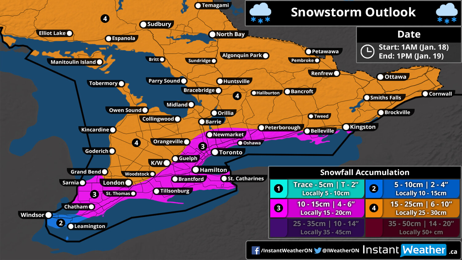
Snowstorm Outlook
Valid: Saturday, January 18, 2020 (1AM) - Sunday, January 19, 2020 (1PM)
Mobile Tip: You can zoom into the map by clicking on it. The map will open in a new tab that is easily zoomable.
Forecast Discussion
Issued: Thursday, January 16, 2020 - 5:40PM
Forecaster: Brennen Perry
A fairly strong snowstorm is expected to impact Southern Ontario this weekend bringing the season’s first widespread significant snowfall for many regions. It appears that weekends are a popular time for Mother Nature this year as the last few storms we’ve had to deal with have also occurred on the weekend. This time we’ll end up on the cold side of this system resulting in mostly snow across Southern Ontario instead of the messy mix of wintry precipitation that has dominated the forecast with the past few storms. We expect the storm to start predawn Saturday and continue throughout the day and into Sunday with the worst conditions during the afternoon and evening on Saturday. Wind gusts will also pick up on Saturday with gusts reaching between 60-80km/h which will likely cause blowing snow and reduced visibility out on the roads. Conditions will improve during the day on Sunday for most areas although lake effect snow may briefly develop around Lake Huron and Georgian Bay late Sunday morning leading to locally higher totals potentially up to 30cm.
The first flakes will begin to fly around 2-4 am starting with Extreme Southwestern Ontario such as Windsor and Sarnia where the snowfall will be quite heavy at times through the morning hours. By late morning, the bands of heavy snow will move into the rest of Southwestern Ontario and the GTA/Niagara region. For Extreme Southwestern Ontario and regions around Lake Erie, we expect some mixing with freezing rain, ice pellets or rain to occur as temperatures climb to near the freezing mark near noon. By the afternoon, the storm will be underway across all of Southern Ontario with heavy snow encompassing the entire area although the snow will become less intense towards the southwest as the bulk of the moisture moves to the northeast. There is some dissagreement among the models on how far north the mixing will get with some suggesting a breif switch over to rain around the Lake Ontario shoreline which would result in lower snow totals. Moderate to heavy snow will continue through Central and Eastern Ontario into the evening and past midnight before clearly overnight and early Sunday morning. As we previously mentioned, some regions mainly east of Georgian Bay and Lake Huron could continue seeing locally heavy snow due to snow squalls developing Sunday morning behind the storm as it exits the province.
When it comes to the expected accumulation, almost every location through Southern Ontario with a few exceptions can expect at least 10cm by the time this storm comes to an end late Saturday or Sunday morning. The highest totals will be found throughout Eastern, Central and parts of Southwestern Ontario where accumulation will range from 15 to 25cm (locally higher around Georgian Bay and Lake Huron where snow squalls on Sunday could push those totals near 30cm). Between 10-15cm of accumulation is expected for areas around the Lake Ontario and Erie shoreline where temperatures will be slightly lower leading to lower snow ratios (the amount of snow produced from 25mm/1” of precipitation) and even some rain mixing in close to the lakeshore. Right now, we expect the Windsor and Leamington area to be the sole area to not see at least 10cm from this storm as the latest data suggest a few hours of heavy snow early Saturday morning but will switch over to freezing rain, ice pellets and rain later in the morning and into Saturday afternoon. It’s still possible that the Windsor area sees over 10cm should the cold air hold on longer than expected so we’ll continue to monitor that and may adjust it in our final forecast to be released on Friday.
The standard disclaimer applies with this storm where it’s still several days away and the forecast could change although there is good agreement among the models at this time. We’ve outlined the potential snowfall from this storm, but it’s certainly not a guarantee. Stay with us over the next few days as we provide more updates on this upcoming snowstorm.
Your business could be here!
If you're interested in connecting your organization with our amazing community by sponsoring our forecasts, please visit: instantweatherinc.com/sponsor
