Potent Storm Brings Freezing Rain, Heavy Rainfall, and Severe Thunderstorm Risk to Southern Ontario on Wednesday
/Forecaster: Brennen Perry
Published: Tuesday, April 4, 2023
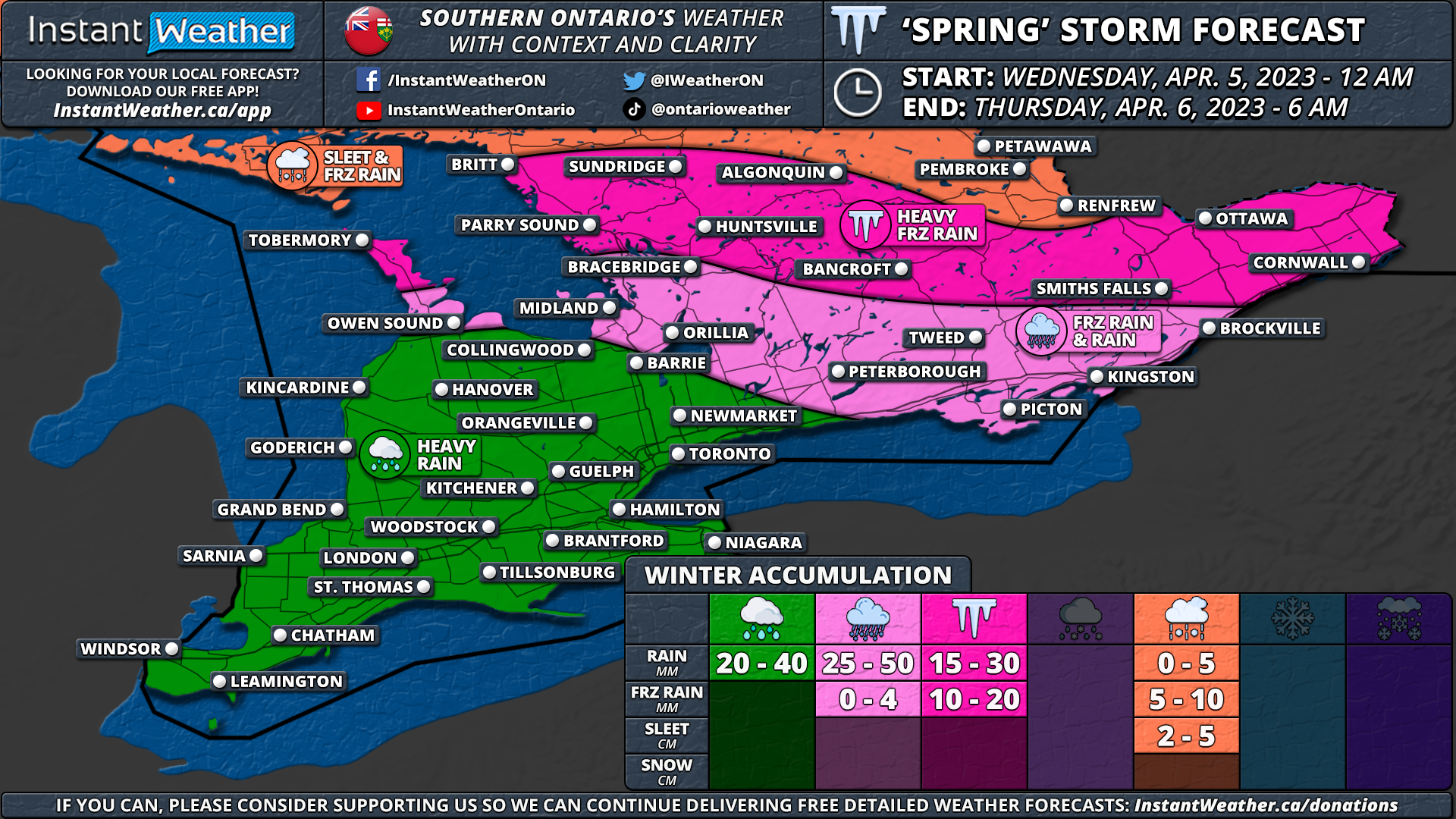
A powerful system arriving from the west is expected to deliver a variety of precipitation types and potential travel disruptions starting early Wednesday morning and lasting throughout the day in Southern Ontario. The strong storm system is expected to reach the region just after midnight, beginning around the Bruce Peninsula and Georgian Bay, before moving further eastward.
As the system encounters colder air over Central and Eastern Ontario, it will lead to the development of a widespread band of freezing rain during the morning hours. In the Ottawa Valley and Algonquin Park, precipitation may initially begin as ice pellets before transitioning to freezing rain. Heavy icing will impact regions such as Simcoe County, Muskoka, Kawartha Lakes, Haliburton, Peterborough, Bancroft, Brockville, Ottawa, Renfrew, Cornwall, and Pembroke.
Ice accretion in the hardest-hit regions could range from 10 to 20mm, and localized power outages cannot be ruled out. Travel conditions in the affected areas are expected to be hazardous due to ice accumulation on untreated surfaces. Consider postponing non-essential travel until late Wednesday and prepare for the likelihood of school bus cancellations throughout Central and Eastern Ontario.
Temperatures are forecast to rise gradually during the mid to late afternoon on Wednesday, which will change freezing rain to rain and help melt any ice accumulation. However, freezing rain may linger into the evening for the Ottawa Valley near the Quebec border.
In the meantime, the rest of Southern Ontario is expected to receive a soaking with 20 to 40mm of rainfall possible by the end of Wednesday. In some areas, particularly where thunderstorm activity occurs, rainfall amounts could be even higher, ranging from 50 to 75mm. This heavy rainfall may lead to localized flooding and ponding on roadways.
Additionally, there is potential for severe thunderstorms in Southwestern Ontario on Wednesday afternoon and early evening. While the strongest risk remains stateside, the possibility of storms crossing the border should not be overlooked, especially in areas like Windsor and Sarnia where the lakes have less influence. The main risks associated with these storms are strong wind gusts and even the chance of an isolated tornado can’t be ruled out. A thunderstorm risk map will be released later tonight and updated tomorrow as needed.
Be sure to stay informed and monitor weather updates as this potent storm system approaches. The impact of freezing rain, heavy rainfall, and possible severe thunderstorms, combined with significant ice accretion and potential power outages, could cause some disruptions to daily routines and travel plans.
Here is an advertisement so we can pay the bills:


