
Southern Ontario: Thunderstorm Outlook for Monday, June 28, 2021
/Forecast Discussion
Thunderstorms are currently not expected in the forecasted region on this day.

Thunderstorms are currently not expected in the forecasted region on this day.

Thunderstorms are currently not expected in the forecasted region on this day.

Non-severe thunderstorms from Saturday evening are expected to continue to affect regions east of Georgian Bay throughout the morning hours on Sunday bringing the threat of flooding since many locations have already seen significant rainfall over the past 24 hours. These storms will move out of the province by late morning.
Another round of storms will develop later in the day during the afternoon as isolated pop-up storms show up through Southwestern Ontario and up into areas around Georgian Bay. A few of these storms could have the potential to reach severe levels with strong wind gusts, large hail and of course very heavy downpours.
Like we saw on Saturday, there could be the risk for one or two tornadoes, but it’s not as strong as the setup on Saturday that produced the Chatsworth tornado. The tornado threat extends from Georgian Bay and east through Central Ontario including Simcoe County, Muskoka, Haliburton and Bancroft. These storms will track to the northeast towards Central and Eastern Ontario along with parts of the Ottawa Valley. The storms should clear out by midnight as they quickly weaken and fizzle out.
Thunderstorms are currently not expected in the forecasted region on this day.
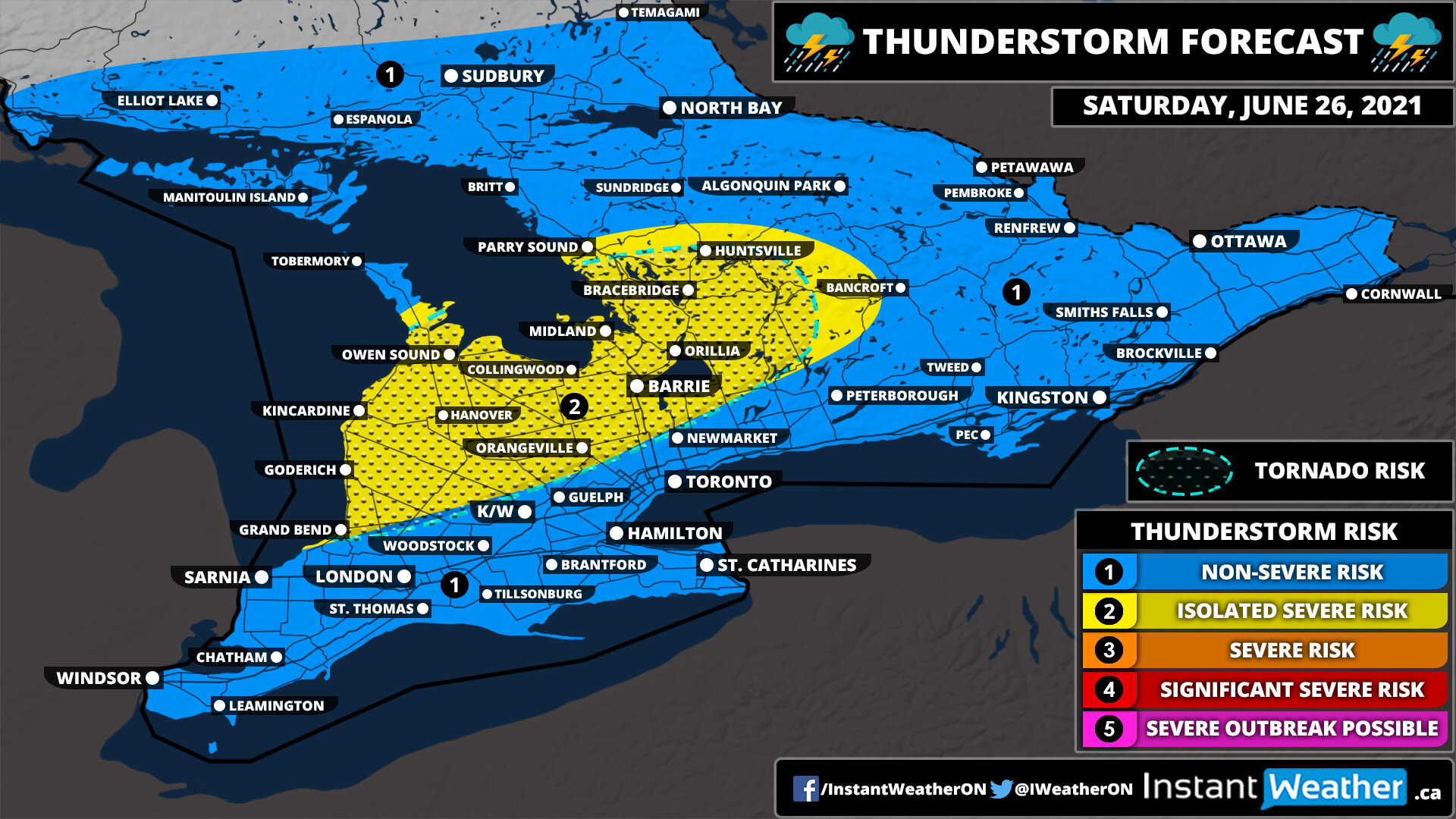
A constant stream of precipitation with embedded thunderstorms will pump into the region starting early Saturday afternoon. There is also the potential for strong thunderstorms to develop during the late afternoon and early evening on Saturday. The main threat will be intense rainfall rates plus strong winds and moderate-size hail. Storms are expected to develop over Lake Huron and track through regions northeast of Lake Huron and east of Georgian Bay. There are indications that a slight tornado risk could exist with these storms. The risk will come to an end by midnight although non-severe storms with a lot of rain will still continue overnight into Sunday morning.

Heavy rainfall and isolated embedded thunderstorms courtesy of a moisture-laden system are expected through southern parts of Northeastern Ontario just to the north of Georgian Bay throughout Friday. The main threat will be very heavy rainfall since the system will pump lots of moisture into the region with rainfall totals by the end of Friday potentially exceeding 50mm in some locations. Strong wind gusts and small hail are also possible in the strongest cells.

Heavy rainfall with embedded non-severe thunderstorms will affect Southern Ontario throughout the day on Friday. The main concern will be the constant stream of moisture being pumped into the region especially in locations that see the embedded thunderstorms so flooding could be an issue. Rainfall totals ranging from 15-30mm are possible around Lake Huron and Georgian Bay with locally as much as 50mm by the end of Friday. More rain is expected on Saturday as the system associated with this precipitation lingers into the weekend with some potentially stronger storms east of Georgian Bay late Saturday into early Sunday morning.
Thunderstorms are currently not expected in the forecasted region on this day.

Scattered non-severe thunderstorms are possible across Northeastern Ontario during the early morning on Thursday as a weakening line of storms from Wednesday evening tracks through the region. There is also the potential for some pop-up isolated storms especially along the Quebec border during the afternoon and evening although they’ll be extremely localized. The main risks will be heavy rainfall and some lightning, but some stronger wind gusts can’t be ruled out.

A line of storms is likely to develop over eastern Manitoba and further strengthen as it moves into Northwestern Ontario during the early evening on Wednesday. One or two of these storms could have the potential to reach severe levels with damaging wind gusts, large hail and heavy rainfall. The severe threat will end just before midnight as the storms weaken while tracking eastward towards Lake Superior. Some non-severe thunderstorms will linger well past midnight and into the overnight hours, but they shouldn’t post much of a threat.
Thunderstorms are currently not expected in the forecasted region on this day.
Thunderstorms are currently not expected in the forecasted region on this day.
Thunderstorms are currently not expected in the forecasted region on this day.
Thunderstorms are currently not expected in the forecasted region on this day.

A very stormy day is ahead for Southern Ontario with multiple waves of potentially severe thunderstorms track across the province. The first wave will come late Sunday evening just before midnight as some decaying storms from Michigan reach Southwestern Ontario around the Windsor area. There are some indications that these storms could bring damaging wind gusts with localized gusts over 100km/h along with small hail and heavy rainfall. The tornado risk appears to be fairly low especially since it’ll be very late in the evening when they reach the area, but it can’t be completely ruled out since there is a tornado risk on the other side of the border. These storms will track to the northeast during the early overnight hours and could bring isolated damaging wind gusts as far east as the KW and Hamilton/Burlington region.
Another cluster of storms is expected to track over Lake Huron and move into parts of Northeastern Ontario just to the north of Georgian Bay early Monday morning. There could be the potential for strong wind gusts and moderate-sized hail associated with these storms as they affect the Manitoulin Island, Sudbury and North Bay area through the morning and even early in the afternoon.
The second and what could be the strongest round of the day will come later on Monday as a line of storms develops during the mid-afternoon somewhere in Central or Eastern Ontario. This line of storms will track eastward into the Ottawa Valley with the ingredients in place for very strong severe storms including damaging wind gusts, large hail, heavy rainfall and even one or two tornadoes. There is still some uncertainty on where this line will develop and how fast it’ll strengthen - it’s possible that the storms may not blow up until they cross into Quebec and Upstate New York which would decrease the threat on the Ontario side of the border.
This main threat for severe storms will be mainly during the late afternoon and early evening although it may linger later into the evening until the storms move out of the region. We’ll continue to monitor this and issue an updated outlook tomorrow morning or early afternoon based on how the morning storms progress.
Thunderstorms are currently not expected in the forecasted region on this day.
Thunderstorms are currently not expected in the forecasted region on this day.
Thunderstorms are currently not expected in the forecasted region on this day.

Non-severe thunderstorms are possible throughout the afternoon and into the early evening hours of Saturday for areas around the Lake Erie shoreline including Extreme Southwestern Ontario. These storms could bring strong wind gusts, small hail and of course very heavy rainfall which could cause localized flooding. The storm threat will quickly come to an end after sunset.
Thunderstorms are currently not expected in the forecasted region on this day.
