Southern Ontario: Thunderstorm Outlook for Tuesday, July 13, 2021

SON-TStorm-Day1.jpg

Forecast Discussion

Widespread thunderstorm activity is expected across Southern Ontario during the day on Tuesday. There is the potential a few of these storms could reach severe levels extending from the Lake Huron shoreline through Central Ontario and including all of Eastern Ontario. The strongest risk will be during the afternoon and evening with the main threats being strong wind gusts and large hail. A tornado can’t be ruled out especially in parts of Eastern Ontario where the environment is favourable for isolated tornadoes, but it’s not extremely strong at this point. We’ll pinpoint the tornado risk (if it still exists) in our final map issued Monday evening.

Northern Ontario: Thunderstorm Outlook for Monday, July 5, 2021

NON_Low-Confidence.jpg

Forecast Discussion

Thunderstorms are possible during the afternoon and evening on Monday throughout Northeastern Ontario. These storms should be mainly non-severe although one or two near-severe storms can’t be ruled out. However, the confidence in this event is low at this time.

Southern Ontario: Thunderstorm Outlook for Monday, July 5, 2021

SON_Low-Confidence.jpg

Forecast Discussion

Thunderstorms are possible during the afternoon and evening on Monday. A few of these storms could be severe mainly through parts of Central and Eastern Ontario with flooding as the main threat. However, the confidence in this event is low at this time.

Southern Ontario: Thunderstorm Outlook for Tuesday, June 29, 2021

Forecast Discussion

Isolated thunderstorms are possible across much of Southern Ontario during the afternoon and evening on Tuesday. The exact strength of these storms is currently unclear although it appears that most should remain non-severe. There is a questionable severe risk through parts of Southwestern Ontario, but there are indications that storm development will be further to the north through Central and Eastern Ontario missing out on the prime environment to the south.

Southern Ontario: Thunderstorm Outlook for Sunday, June 27, 2021

Forecast Discussion

There could be the potential for non-severe thunderstorms across Southern Ontario on Sunday as the system that is bringing lots of rain to the region over the weekend continues into Sunday. How widespread these storms will be and the exact intensity remains unclear at this point.

Southern Ontario: Thunderstorm Outlook for Saturday, June 26, 2021

Forecast Discussion

Rainfall continues into Saturday with embedded non-severe thunderstorms possible across Southern Ontario. The strongest storms will be found through Central and Eastern Ontario during the late afternoon into the evening and could even come near severe levels, especially with the flood risk although for now, we’re sticking with the non-severe risk zone and not introducing any isolated severe risk zones. Rainfall totals could be quite significant in some areas with between 50-75mm possible by the end of Saturday. Strong wind gusts and small hail could also be found in some of the stronger storms.

Southern Ontario: Thunderstorm Outlook for Friday, June 25, 2021

Forecast Discussion

A strong system expected to bring very heavy rainfall to regions east of Lake Huron and around Georgian Bay could also have a few embedded non-severe thunderstorms throughout the day on Friday. These thunderstorms won’t be particularly strong except for some lightning and maybe stronger wind gusts. But some locations east of Georgian Bay could see these storms ‘train’ over the area for several hours with significant rainfall totals up to 50mm. Flash flooding will be a huge concern - a separate forecast for the rainfall will be issued closer to the event with the rain continuing into the weekend.

Northern Ontario: Thunderstorm Outlook for Thursday, June 24, 2021

NON_Low-Confidence.jpg

Forecast Discussion

A few non-severe storms are possible across Northeastern Ontario during the morning on Thursday as a decaying line of storms track across the region. There could also be some isolated storms later in the afternoon and evening for Northeastern Ontario although the strength and coverage of this event are currently uncertain.

Southern Ontario: Thunderstorm Outlook for Monday, June 21, 2021

Forecast Discussion

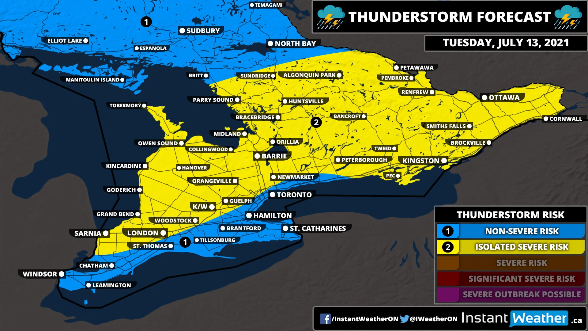
A line of thunderstorms may track into Southwestern Ontario and perhaps around Georgian Bay during the early morning hours on Monday. They should remain sub-severe although can’t rule out localized damaging wind gusts and some flash flooding due to the potential for ‘training’ storms. It’s possible that a few locations could see 2-4 hours of persistent thunderstorm activity with rainfall totals near 25-50mm/hour so it could quickly add up. The exact location and timing of this line of storms are still unclear so who sees the heaviest rainfall still needs to be narrowed down.

There is also a second round of storms could develop later in the afternoon and into the evening as a cold front sweeps across the region. The best chance for storm development appears to be over Eastern Ontario and into the Niagara region as storms pop up and track eastward across the American border. If the cold front is later than expected it could shift the risk further west into the GTA and areas around Lake Simcoe/Georgian Bay. The environment would be favourable for any storm that develops to quickly become severe with damaging wind gusts and large hail. The risk of a tornado is low, but can’t be ruled out. Storms will move out of the province by the late evening making for a quiet Monday night.

Southern Ontario: Thunderstorm Outlook for Friday, June 18, 2021

SON_Low-Confidence.jpg

Forecast Discussion

A decaying complex of thunderstorms could track into Southwestern Ontario during the early morning hours on Friday. Current data suggests it will survive overnight as it tracks across Michigan although it’s possible it could fizzle out before reaching the border. Thunderstorms are also possible across Southern Ontario later in the day and a few of these could pose an isolated severe risk. More details to come as the event draws closer.