
Northern Ontario: Thunderstorm Outlook for Sunday, June 27, 2021
/Forecast Discussion
Thunderstorms are currently not expected in the forecasted region on this day.

Thunderstorms are currently not expected in the forecasted region on this day.

Non-severe thunderstorms from Saturday evening are expected to continue to affect regions east of Georgian Bay throughout the morning hours on Sunday bringing the threat of flooding since many locations have already seen significant rainfall over the past 24 hours. These storms will move out of the province by late morning.
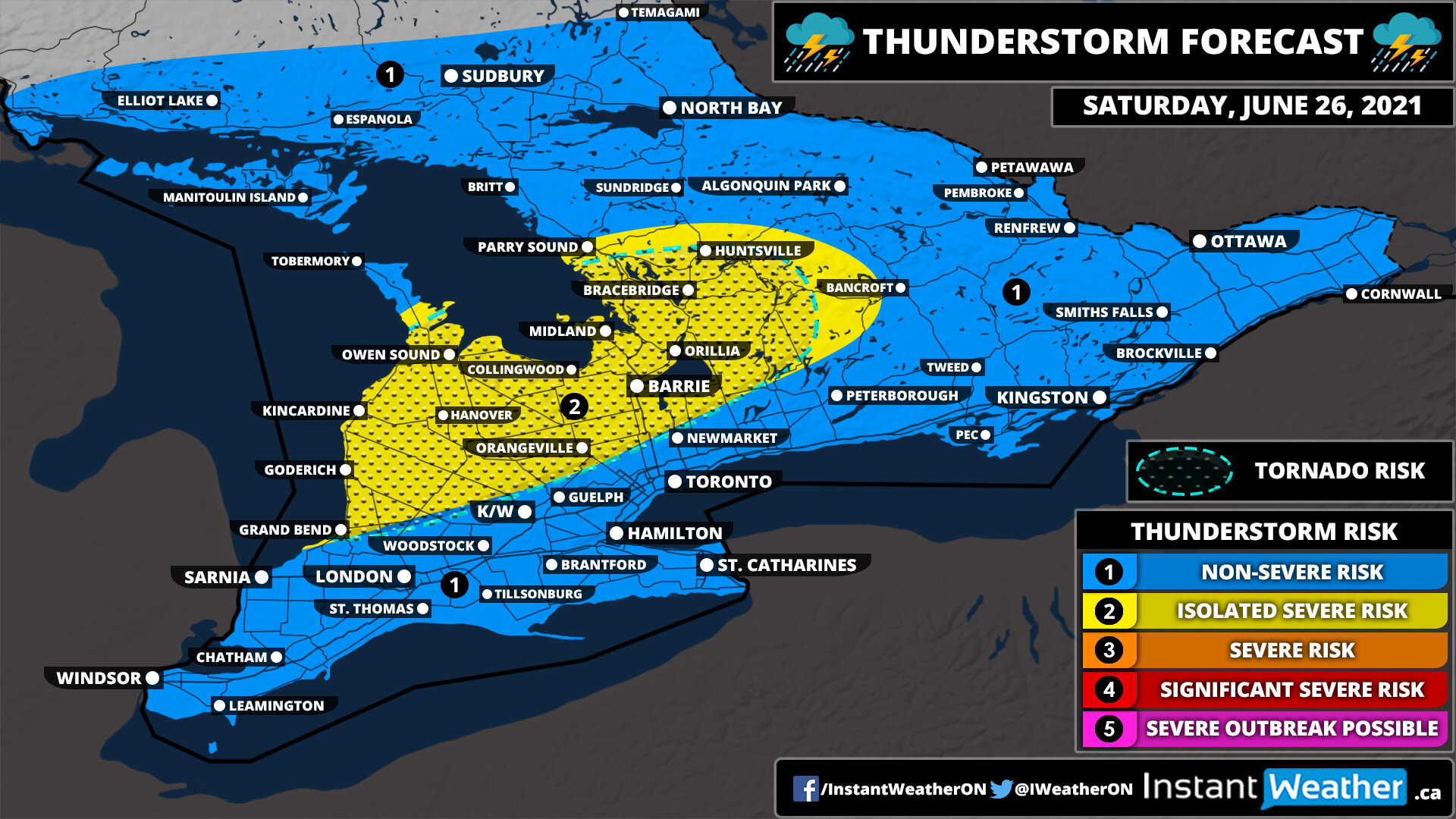
Another round of storms will develop later in the day during the afternoon as isolated pop-up storms show up through Southwestern Ontario and up into areas around Georgian Bay. A few of these storms could have the potential to reach severe levels with strong wind gusts, large hail and of course very heavy downpours.
Like we saw on Saturday, there could be the risk for one or two tornadoes, but it’s not as strong as the setup on Saturday that produced the Chatsworth tornado. The tornado threat extends from Georgian Bay and east through Central Ontario including Simcoe County, Muskoka, Haliburton and Bancroft. These storms will track to the northeast towards Central and Eastern Ontario along with parts of the Ottawa Valley. The storms should clear out by midnight as they quickly weaken and fizzle out.
Thunderstorms are currently not expected in the forecasted region on this day.

There could be the potential for non-severe thunderstorms across Southern Ontario on Sunday as the system that is bringing lots of rain to the region over the weekend continues into Sunday. How widespread these storms will be and the exact intensity remains unclear at this point.
A constant stream of precipitation with embedded thunderstorms will pump into the region starting early Saturday afternoon. There is also the potential for strong thunderstorms to develop during the late afternoon and early evening on Saturday. The main threat will be intense rainfall rates plus strong winds and moderate-size hail. Storms are expected to develop over Lake Huron and track through regions northeast of Lake Huron and east of Georgian Bay. There are indications that a slight tornado risk could exist with these storms. The risk will come to an end by midnight although non-severe storms with a lot of rain will still continue overnight into Sunday morning.

Don’t forget your umbrella if you plan to be outside this weekend! Mother Nature is planning on turning on the taps across Southern Ontario as an active storm track sets up across the region and pumps significant amounts of moisture over the next few days. There will also be the potential for embedded thunderstorms within all this moisture which will only further increase the rainfall totals over the next 72 hours.
By the end of the weekend, we could be talking about triple-digit rainfall totals with the hardest-hit regions seeing between 50-100mm and perhaps locally up to 125-150mm. The focus for the highest totals will be on the Lake Huron shoreline through Central Ontario and into parts of Eastern Ontario near the Quebec border with lower amounts the more south/east or north/west you go.
If you aren’t a fan of the rain, the good news is that this won’t make a mess of the entire weekend and there will be short dry slots between the multiple rounds of rain over the next few days. The rain has already started across Southern Ontario with moderate to heavy rainfall throughout the day on Friday. This is expected to linger into the overnight hours before tapering off somewhat early Saturday morning, but scattered showers may linger around especially through Eastern Ontario.
Although the break will be short-lived as more moisture builds in from the west by Saturday afternoon. This wound could bring some quite intense and potentially near-severe thunderstorms during the evening hours on Saturday for regions east of Georgian Bay. At a minimum, these storms will pack a punch with very intense rainfall rates and some ‘training’ potential where the storms line up for hours over a particular location. Some stronger wind gusts and moderate-sized hail could also be associated with some of the more intense storms, but the exact severity remains unclear. This will be covered in a separate thunderstorm outlook for Saturday to be issued late Friday.
This heavy rain will continue throughout the overnight hours on Saturday and into Sunday morning with the bulk of the precipitation to the north of the GTA affecting Central and Eastern Ontario. It should move out of the province by Sunday mid-morning and allow for a fairly dry day on Sunday with the exception of some scattered showers and pop-up thunderstorms near Lake Huron towards the evening on Sunday. More rain will continue on and off for the early part of next week although we’re not expecting anything widespread or intense so we won’t be including it in this forecast.
The map above should give a rough idea of how much rain to expect over the next 3 days including what has already fallen on Friday. It’s important to note that at first glance the numbers on the map may appear quite extreme as we usually see severe flooding with just 50-75mm from a thunderstorm let alone 100+mm. The thing to remember that all this rainfall will be spread out over 72 hours rather than just a few hours that we see with the major flooding events in the past.
Regardless, we haven’t really seen a lot of rain over the past few months so this will be a significant amount of rain for the ground to absorb and flooding will be quite likely to an extent. Since thunderstorms will be embedded within the precipitation over the next few days it will result in highly variable rainfall totals even within a small area. For example, one location may see 50mm while another gets 150mm. That’s why our forecast ranges are quite large since this event is very tricky to narrow down the exact amount of rain a location will see.

Heavy rainfall and isolated embedded thunderstorms courtesy of a moisture-laden system are expected through southern parts of Northeastern Ontario just to the north of Georgian Bay throughout Friday. The main threat will be very heavy rainfall since the system will pump lots of moisture into the region with rainfall totals by the end of Friday potentially exceeding 50mm in some locations. Strong wind gusts and small hail are also possible in the strongest cells.
Rainfall continues into Saturday with embedded non-severe thunderstorms possible across Southern Ontario. The strongest storms will be found through Central and Eastern Ontario during the late afternoon into the evening and could even come near severe levels, especially with the flood risk although for now, we’re sticking with the non-severe risk zone and not introducing any isolated severe risk zones. Rainfall totals could be quite significant in some areas with between 50-75mm possible by the end of Saturday. Strong wind gusts and small hail could also be found in some of the stronger storms.

Heavy rainfall with embedded non-severe thunderstorms will affect Southern Ontario throughout the day on Friday. The main concern will be the constant stream of moisture being pumped into the region especially in locations that see the embedded thunderstorms so flooding could be an issue. Rainfall totals ranging from 15-30mm are possible around Lake Huron and Georgian Bay with locally as much as 50mm by the end of Friday. More rain is expected on Saturday as the system associated with this precipitation lingers into the weekend with some potentially stronger storms east of Georgian Bay late Saturday into early Sunday morning.

A strong system expected to bring very heavy rainfall to regions east of Lake Huron and around Georgian Bay could also have a few embedded non-severe thunderstorms throughout the day on Friday. These thunderstorms won’t be particularly strong except for some lightning and maybe stronger wind gusts. But some locations east of Georgian Bay could see these storms ‘train’ over the area for several hours with significant rainfall totals up to 50mm. Flash flooding will be a huge concern - a separate forecast for the rainfall will be issued closer to the event with the rain continuing into the weekend.

Thunderstorms are currently not expected in the forecasted region on this day.

Scattered non-severe thunderstorms are possible across Northeastern Ontario during the early morning on Thursday as a weakening line of storms from Wednesday evening tracks through the region. There is also the potential for some pop-up isolated storms especially along the Quebec border during the afternoon and evening although they’ll be extremely localized. The main risks will be heavy rainfall and some lightning, but some stronger wind gusts can’t be ruled out.

A few non-severe storms are possible across Northeastern Ontario during the morning on Thursday as a decaying line of storms track across the region. There could also be some isolated storms later in the afternoon and evening for Northeastern Ontario although the strength and coverage of this event are currently uncertain.

A line of storms is likely to develop over eastern Manitoba and further strengthen as it moves into Northwestern Ontario during the early evening on Wednesday. One or two of these storms could have the potential to reach severe levels with damaging wind gusts, large hail and heavy rainfall. The severe threat will end just before midnight as the storms weaken while tracking eastward towards Lake Superior. Some non-severe thunderstorms will linger well past midnight and into the overnight hours, but they shouldn’t post much of a threat.
Thunderstorms are currently not expected in the forecasted region on this day.
Thunderstorms are currently not expected in the forecasted region on this day.
Thunderstorms are currently not expected in the forecasted region on this day.
Thunderstorms are currently not expected in the forecasted region on this day.

A very stormy day is ahead for Southern Ontario with multiple waves of potentially severe thunderstorms track across the province. The first wave will come late Sunday evening just before midnight as some decaying storms from Michigan reach Southwestern Ontario around the Windsor area. There are some indications that these storms could bring damaging wind gusts with localized gusts over 100km/h along with small hail and heavy rainfall. The tornado risk appears to be fairly low especially since it’ll be very late in the evening when they reach the area, but it can’t be completely ruled out since there is a tornado risk on the other side of the border. These storms will track to the northeast during the early overnight hours and could bring isolated damaging wind gusts as far east as the KW and Hamilton/Burlington region.
Another cluster of storms is expected to track over Lake Huron and move into parts of Northeastern Ontario just to the north of Georgian Bay early Monday morning. There could be the potential for strong wind gusts and moderate-sized hail associated with these storms as they affect the Manitoulin Island, Sudbury and North Bay area through the morning and even early in the afternoon.
The second and what could be the strongest round of the day will come later on Monday as a line of storms develops during the mid-afternoon somewhere in Central or Eastern Ontario. This line of storms will track eastward into the Ottawa Valley with the ingredients in place for very strong severe storms including damaging wind gusts, large hail, heavy rainfall and even one or two tornadoes. There is still some uncertainty on where this line will develop and how fast it’ll strengthen - it’s possible that the storms may not blow up until they cross into Quebec and Upstate New York which would decrease the threat on the Ontario side of the border.
This main threat for severe storms will be mainly during the late afternoon and early evening although it may linger later into the evening until the storms move out of the region. We’ll continue to monitor this and issue an updated outlook tomorrow morning or early afternoon based on how the morning storms progress.

A line of thunderstorms may track into Southwestern Ontario and perhaps around Georgian Bay during the early morning hours on Monday. They should remain sub-severe although can’t rule out localized damaging wind gusts and some flash flooding due to the potential for ‘training’ storms. It’s possible that a few locations could see 2-4 hours of persistent thunderstorm activity with rainfall totals near 25-50mm/hour so it could quickly add up. The exact location and timing of this line of storms are still unclear so who sees the heaviest rainfall still needs to be narrowed down.
There is also a second round of storms could develop later in the afternoon and into the evening as a cold front sweeps across the region. The best chance for storm development appears to be over Eastern Ontario and into the Niagara region as storms pop up and track eastward across the American border. If the cold front is later than expected it could shift the risk further west into the GTA and areas around Lake Simcoe/Georgian Bay. The environment would be favourable for any storm that develops to quickly become severe with damaging wind gusts and large hail. The risk of a tornado is low, but can’t be ruled out. Storms will move out of the province by the late evening making for a quiet Monday night.
