
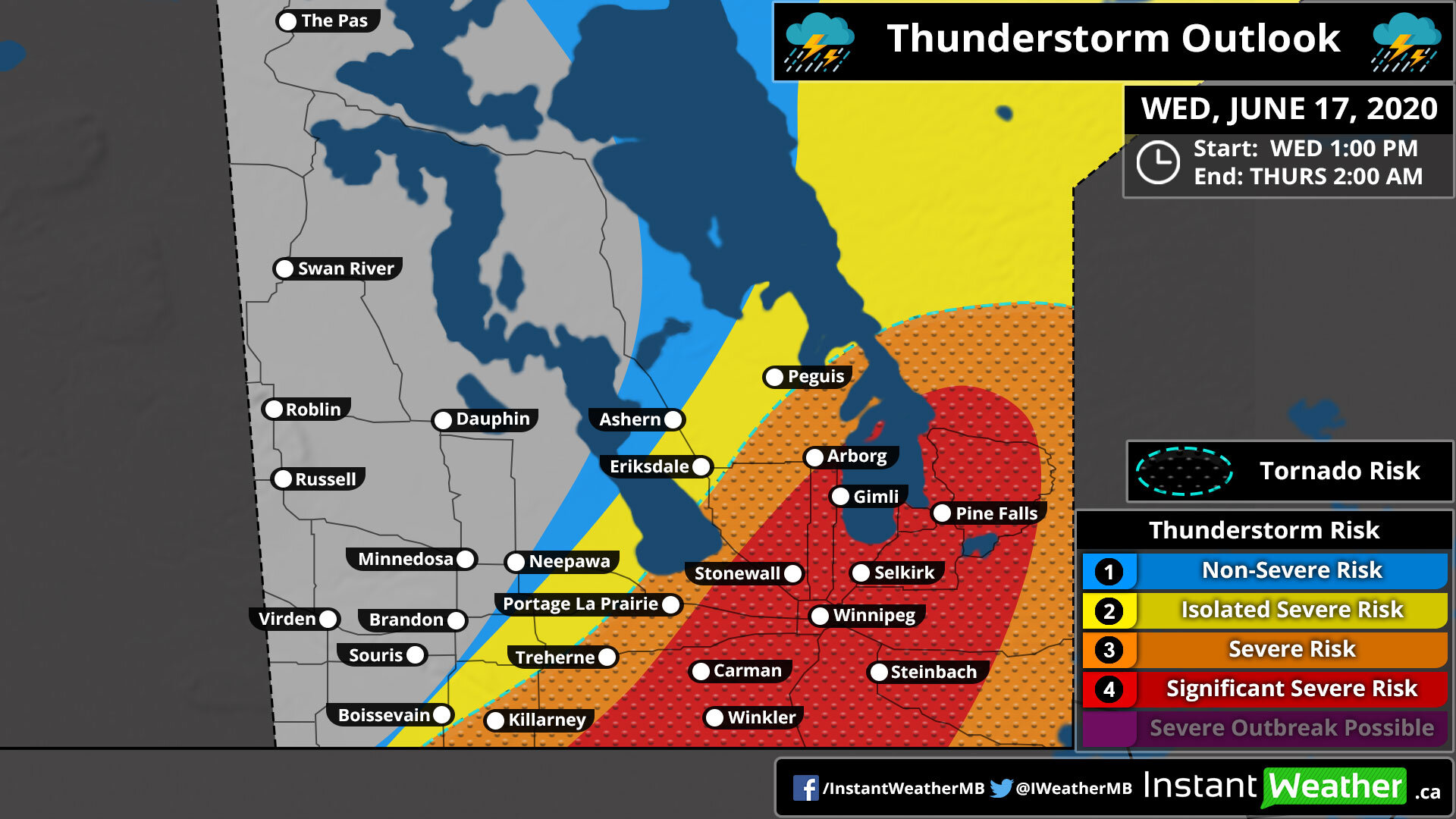
Thunderstorm Outlook
Valid: WEDNESDAY, JUNE 17, 2020
Forecaster: Adam Skinner
CLICK THE IMAGE TO SEE A LARGER IMAGE THAT YOU CAN ZOOM
NOTE: The tornado risk zone outlines the region with the highest probability of tornadoes, but tornadoes may occur outside of the zone.
|
Forecast Discussion
Issued: WEDNESDAY, JUNE 17, 2020 - 11:15AM
Another significant weather risk is upon some populated areas of Manitoba, especially for those in the southeast. Other areas besides the southeast that we have highlighted in yellow may see very isolated severe thunderstorms but it is possible that many areas to the west will be completely missed and may see zero activity today and tonight. These storms will bring with them the risk for damaging wind gusts 90km/h - 110km/h+, 2-5cm hail (golf ball), significant flooding, and the risk for one or two tornadoes with a significant tornado not entirely out of the question, especially in the red area on our map.
Isolated severe storms are possible this afternoon and eventually this will turn into a large clustered of severe thunderstorms towards the evening hours. This risk will continue late into the evening for some and possibly into overnight hours for areas closer to the Ontario border. The flooding risk is fairly substantial, especially for areas that see more than one storm in a row, and especially for areas in central Manitoba based on the model data showing several inches for some areas. Please be safe in the path of these storms folks! - Adam
Thunderstorm Threatcast
|
|
|
|
|
|
|
|
|
|
|
Long story short, please have a plan if you’re in the affected areas, especially in eastern Manitoba and we’ll be posting updates as soon as we begin to have storm development. Those updates will be on our social media pages and to receive alerts instantly on your mobile device, check storm arrival time for your exact location, and watch radar as they arrive, download our new FREE app Instant Weather:


Environment Canada has also created a forecast for today’s risk and they wrote:
Area(s): Southern into central Manitoba
Timing: Wednesday afternoon and evening
Threats: Southeast: Torrential rainfall with local accumulations of 50-100 mm, hail 3 to 5 cm, and winds gusts of 100 km/h or higher. Elsewhere: Hail 2 to 4 cm and wind gusts of 90 km/h.
A slow moving cold front will trigger thunderstorms in the afternoon over a very humid southeastern Manitoba. There is the threat of large hail and damaging wind gusts early in storm development, but as thunderstorms grow more widespread threats will shift more towards damaging wind gusts and torrential rainfall. Local rain amounts well in excess of 50 mm are possible in southeast Manitoba. Elsewhere over southern and central Manitoba, isolated thunderstorms may develop behind the front; while generally non-severe, a few strong thunderstorms will be possible.

CLICK THE IMAGE FOR A LARGER IMAGE YOU CAN ZOOM
PLEASE READ: For those wondering, these "prototype" maps are not yet available on EC's website. However, they will become operational soon and shared directly on their site. These forecasts and maps are issued by the same Environment Canada Meteorologists that issues all Watches and Warnings for the prairies. They're also temporarily hosted by the University of Manitoba here:
https://umanitoba.ca/faculties/environment/envirogeog/weather/conv_otlk/
Environment Canada's disclaimer says:
"Disclaimer: These products are part of an experimental initiative at Environment and Climate Change Canada (ECCC). These are not official ECCC products and therefore may not be available on a daily basis. Please continue to monitor weather forecasts as well as watches and warnings via http://www.weather.gc.ca/. Please address any questions, concerns and/or feedback regarding these products to the Decision Support Meteorologists at the Prairie and Arctic Storm Prediction Centre, available by email at ec.soutienmeteoouest-weathersupportwest.ec@canada.ca."
More details ASAP!
Adam
