
Thunderstorm Outlook
Valid: Wednesday, June 10, 2020 (2PM) - Thursday, June 11, 2020 (5AM)
Forecaster: Brennen Perry
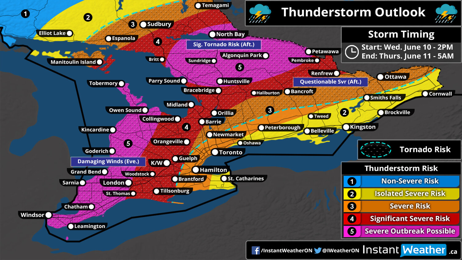
Thunderstorm outlook map
NOTE: The tornado risk zone outlines the region with the highest probability of tornadoes, but tornadoes may occur outside of the zone.
Southwestern: 6PM - 10PM
|
Not sure what region you are in? Click here for a map showing the regions across Southern Ontario. Northeastern Ontario is north of North Bay (not shown on map).
Thunderstorm Threatcast
Very High (90%) |
|
High (75%) |
|
Several (Strong Possible) |
|
120+ kmh | 75+ mph |
|
Walnut |
|
~75 mm | ~3" |
Forecast Discussion
Issued: Wednesday, June 10, 2020 - 3:20PM
A severe thunderstorm outbreak is looking increasingly likely for parts of Southern Ontario beginning this afternoon and lasting through the evening and early overnight hours. The main concern is with a line of intense storms developing over Michigan late this afternoon and tracking into Southwestern Ontario by the early evening. This line stretching from the Bruce Peninsula to Windsor has the potential to produce widespread damaging wind gusts over 100-120km/h along its path as it tracks to the east.
It will weaken somewhat throughout the evening hours so the worst conditions will likely be found in the most western part of the region such as areas around Lake Huron and into Extreme Southwestern Ontario. While damaging wind gusts are the main risk with this line, large hail up to walnut size and even one or two tornadoes can’t be ruled out. It’s expected to reach the GTA around 9-10 PM with some embedded wind gusts up to 100km/h although most of the line should be non-severe by this point as it reaches areas east of Lake Simcoe. After sunset, the lack of daylight heating will result in the line to quickly break apart and decay as it works its way into Eastern Ontario around midnight - isolated severe gusts still can’t be ruled out.
A secondary risk zone that we’re closely watching includes areas to the northeast of Georgian Bay and along the Quebec border where the environment is extremely favourable for any storms to quickly become severe this afternoon. This includes the risk for tornadoes (potentially a strong tornado) along with large hail and strong wind gusts. Now, this risk is more questionable because some data suggest that storms won’t develop to take advantage of the prime environment. This concern is starting to disappear though because the latest models do show several discrete cells developing between 3-6 PM somewhere near Parry Sound and Huntsville then track to the east towards Algonquin Park and Petawawa. There’s also some risk through the Ottawa Valley, but storm development is even more questionable in this area.
