
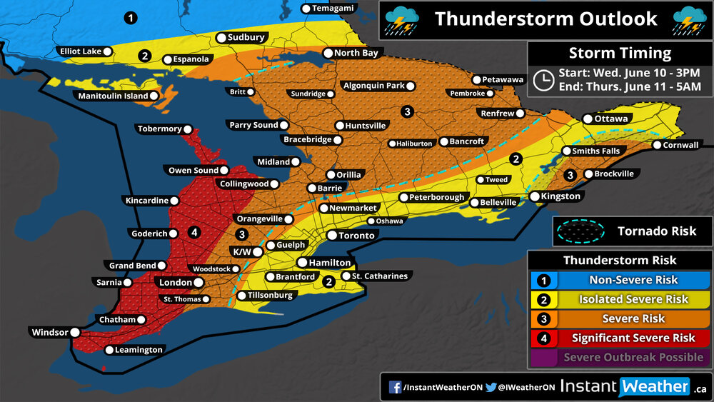
Thunderstorm Outlook
Valid: Wednesday, June 10, 2020 (3PM) - Thursday, June 11, 2020 (5AM)
Forecaster: Brennen Perry
Thunderstorm outlook map
NOTE: The tornado risk zone outlines the region with the highest probability of tornadoes, but tornadoes may occur outside of the zone.
Southwestern: 3PM - 1AM
|
Not sure what region you are in? Click here for a map showing the regions across Southern Ontario. Northeastern Ontario is north of North Bay (not shown on map).
Thunderstorm Threatcast
Very High (90%) |
|
Moderate (50%) |
|
One or Two |
|
110+ kmh | 68+ mph |
|
Toonie |
|
~50 mm | ~2" |
Forecast Discussion
Issued: Tuesday, June 10, 2020 - 6:30PM
A volatile day of active weather is ahead for Southern Ontario on Wednesday as the remnants of post-tropical depression Cristobal slowly strengthens as it approaches Northern Ontario and moves over Hudson Bay. Wednesday will start with a line of heavy rainfall and embedded non-severe thunderstorms sweeping across Southern Ontario during the morning hours. This will set the stage for a humid and unstable day as temperatures reach into the upper 20s and lower 30s by the afternoon. With the humidity, it could feel like the upper 30s in some areas so be sure to stay hydrated and avoid prolonged exposure to the extreme heat!
As we head into the late afternoon, the severe potential will begin to build in as storms build over Michigan and Ohio and track northeastward into Southwestern Ontario. This first round of storms is questionable and some models suggest that storm development is delayed until the evening hours. If these afternoon/early evening storms develop, they could pose a very significant and widespread damaging wind gust risk with the possibility of gusts over 110km/h. The areas at the highest risk of the strong wind gusts including Windsor, Sarnia, Grand Bend, London, Goderich, Kincardine and Owen Sound. The storms will track over Georgian Bay and affect the Muskoka and Algonquin Park region around the dinner hour. We’re also noticing the potential for some storm development during the early evening near Smiths Falls and Brockville which could become severe based on the environment. Large hail up to toonie size and heavy rainfall is also a concern although not the main threat. One or two tornadoes can’t be ruled out somewhere in our ‘tornado risk’ zone outlined on the forecast.
There’s more confidence in either the first or second line of storms (depending on if the earlier cluster develops) crossing into Southwestern Ontario towards the mid to late evening hours. This line will be likely in the form of a squall line with damaging wind gusts over 90-100km/h as the main threat. The hail and tornado risk isn’t zero but will be much lower compared to earlier in the day. This line will reach the GTA and areas around Lake Simcoe near midnight and should be mostly non-severe at this point, but isolated wind damage is still possible. The decaying squall line will continue to track towards the east during the overnight hours clearing out of the province by early Thursday morning.
