
Thunderstorm Outlook
Valid: Sunday, July 19, 2020
Forecaster: Brennen Perry
Issued: Sunday, July 19, 2020 - 1:30AM
UPDATED: Sunday, July 19, 2020 - 11:40AM
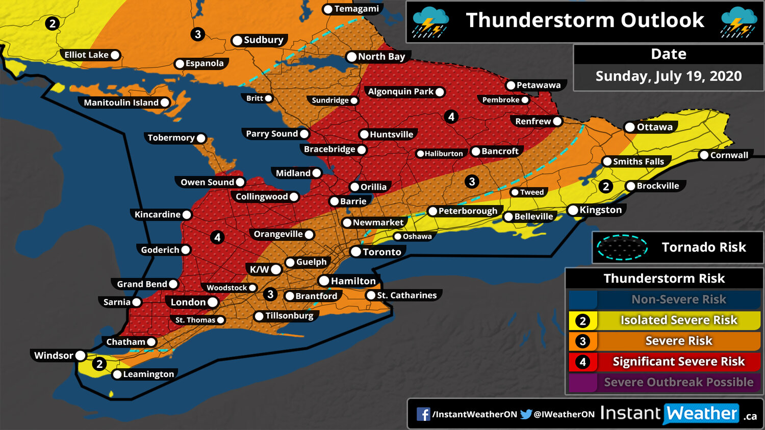
Thunderstorm outlook map
MOBILE TIP: YOU CAN ZOOM INTO THE MAP BY CLICKING ON IT. THE MAP WILL OPEN IN A NEW TAB THAT IS EASILY ZOOMABLE.
NOTE: The tornado risk zone outlines the region with the highest probability of tornadoes, but tornadoes may occur outside of the zone.
Southwestern: 9AM - 7PM
|
Not sure what region you are in? Click here for a map showing the regions across Southern Ontario. Northeastern Ontario is north of North Bay (not shown on map).
Thunderstorm Threatcast
Very High (90%) |
|
High (75%) |
|
Several |
|
110+ kmh | 68+ mph |
|
Golf Ball |
|
~75 mm | ~3" |
Forecast Discussion
UPDATE:
The first round of storms has arrived this morning prompting several tornado warnings and watches across parts of Southwestern Ontario. We continue to monitor the potential for the second round of storms later this afternoon and into the evening - the latest data indicates the threat has now expanded into Southwestern Ontario including similar locations being impacted by the tornado warned storms this morning. It’s important to note that we aren’t factoring in the current storms into this forecast for Southwestern Ontario, this is for a separate round of storms later today that will impact the same regions. The risk for significant severe storms now encompasses most of Central Ontario, around Georgian Bay and down into areas to the east of Lake Huron. This includes the threat of several tornadoes along with large hail, destructive wind gusts and heavy rainfall.
Original Discussion:
A very complex day with several rounds of severe storms is expected across Southern Ontario on Sunday. It will all start early Sunday morning as a line of storms with the potential to produce widespread wind gusts will develop during the overnight hours through Michigan and crossing over Lake Huron/Georgian Bay by mid to late morning. This will bring mainly a wind risk to parts of Southwestern and Central Ontario. There is also a pretty substantial tornado risk with this line and it could easily put down a few tornadoes. The first round should stay to the north of the GTA with a focus on cottage country.
We expected the second round of storms to bubble up towards the late afternoon somewhere just east of Lake Huron and extending up through Central Ontario and along the Quebec border. These storms will be more discrete and could see all modes of severe weather including very large hail up to golf ball size, 110km/h wind gusts and tornadoes. We're closely watching the corridor from Midland through Lake Simcoe and up into Bancroft where the highest threat for severe weather exists. The risk will come to an end during the evening as the storms weaken and track towards Eastern Ontario. Now this second round is highly dependant on the timing of the morning storms. If the morning storms show up much more later than expected than it would reduce the timeframe for daylight heating to build up the instability and could cause the second round to be much weaker or just not happen.
