
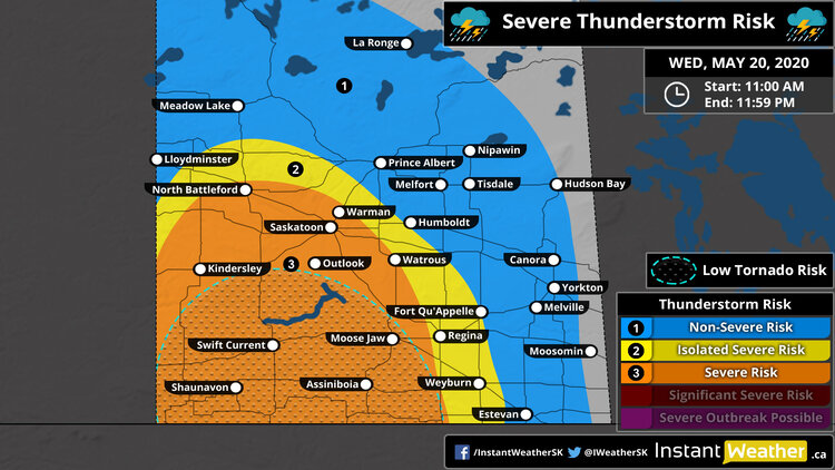
Severe Thunderstorm Outlook
Valid: Wednesday, May 20th, 2020 (11:00 AM - 11:59 PM)
Forecaster: Adam Skinner
NOTE: CLick the map to see a larger image that you can zoom
This afternoon into the evening and overnight hours in parts of southern and southwestern Saskatchewan. |
Thunderstorm Threatcast
Very High (90%) |
|
Moderate (50%) |
|
Isolated |
|
95+ kmh | 59+ mph |
|
Walnut |
|
~50 mm | ~2" |
Forecast Discussion
Issued: Wednesday, May 20th, 2020 at 2:00 PM
Severe thunderstorms this morning and early afternoon continue into the late afternoon and evening with the risk of 2-4cm hail, damaging wind gusts 95km/h+, torrential rain, frequent lightning, and an a low (questionable) risk for an isolated, brief tornado in deep southwestern Saskatchewan. Storms will continue to track north, northwest through the region this afternoon and evening and the main risk continues to be large hail and damaging wind gusts.
We’ll be posting all the updates to our social media pages and to receive alerts instantly on your mobile device, check storm arrival time for your exact location, and watch radar as they arrive, download our new free app Instant Weather:


Environment Canada has issued a Severe Thunderstorm Watch for this event (along with a few Severe Thunderstorm Warnings):

Here’s what they wrote:
11:14a SEVERE THUNDERSTORM WATCH ISSUED by Environment Canada
(Locations listed below description)
Conditions are favourable for the development of severe thunderstorms that may be capable of producing strong wind gusts, large hail and heavy rain.
A low pressure system over eastern montana moving northward into southern saskatchewan is triggering thunderstorms this afternoon. Some of these thunderstorms are expected to become severe later this afternoon and evening.
Be prepared for severe weather. Take cover immediately, if threatening weather approaches.
Severe thunderstorm watches are issued when atmospheric conditions are favourable for the development of thunderstorms that could produce one or more of the following: large hail, damaging winds, torrential rainfall.
Please continue to monitor alerts and forecasts issued by environment canada. To report severe weather, send an email to skstorm@canada.ca or tweet reports using #skstorm.
end/paspc
NEW:
- City of Moose Jaw
- R.M. of Arlington including Dollard
- R.M. of Auvergne including Ponteix and Aneroid
- R.M. of Baildon including Briercrest
- R.M. of Bengough including Bengough
- R.M. of Big Stick including Golden Prairie
- R.M. of Bone Creek including Simmie and Scotsguard
- R.M. of Canaan including Lucky Lake
- R.M. of Carmichael including Carmichael
- R.M. of Caron including Caronport and Caron
- R.M. of Chaplin including Chaplin
- R.M. of Clinworth including Sceptre Lemsford and Portreeve
- R.M. of Coulee including Neidpath and McMahon
- R.M. of Craik including Craik and Aylesbury
- R.M. of Deer Forks including Burstall and Estuary
- R.M. of Dufferin including Bethune and Findlater
- R.M. of Elmsthorpe including Avonlea and Truax
- R.M. of Enfield including Central Butte
- R.M. of Enterprise including Richmound
- R.M. of Excel including Viceroy Ormiston and Verwood
- R.M. of Excelsior including Waldeck Rush Lake and Main Centre
- R.M. of Eyebrow including Eyebrow and Brownlee
- R.M. of Fox Valley including Fox Valley
- R.M. of Frontier including Frontier and Claydon
- R.M. of Glen Bain including Glen Bain
- R.M. of Glen McPherson west of Mankota
- R.M. of Grassy Creek including Shaunavon
- R.M. of Gravelbourg including Gravelbourg and Bateman
- R.M. of Gull Lake including Gull Lake and Tompkins
- R.M. of Happy Valley including Big Beaver
- R.M. of Happyland including Leader Prelate and Mendham
- R.M. of Hart Butte including Coronach
- R.M. of Hillsborough including Crestwynd and Old Wives lake
- R.M. of Huron including Tugaske
- R.M. of Key West including Ogema and Kayville
- R.M. of Lac Pelletier including Blumenhof
- R.M. of Lacadena including Kyle Tyner and Sanctuary
- R.M. of Lake Johnson including Mossbank and Ardill
- R.M. of Lake of The Rivers including Assiniboia
- R.M. of Lawtonia including Hodgeville
- R.M. of Lone Tree including Climax and Bracken
- R.M. of Mankota including Mankota and Ferland
- R.M. of Maple Bush including Riverhurst and Douglas Prov. Park
- R.M. of Maple Creek including Cypress Hills Prov. Park
- R.M. of Maple Creek including Maple Creek
- R.M. of Marquis including Tuxford Keeler and Buffalo Pound
- R.M. of Miry Creek including Abbey Lancer and Shackleton
- R.M. of Moose Jaw including Pasqua and Bushell Park
- R.M. of Morse including Herbert Morse Ernfold and Gouldtown
- R.M. of Old Post including Wood Mountain and Killdeer
- R.M. of Pense including Pense Belle Plaine and Stony Beach
- R.M. of Piapot including Piapot
- R.M. of Pinto Creek including Kincaid and Hazenmore
- R.M. of Pittville including Hazlet
- R.M. of Poplar Valley including Rockglen and Fife Lake
- R.M. of Redburn including Rouleau and Hearne
- R.M. of Reno including Consul Robsart and Willow Creek
- R.M. of Riverside including Cabri Pennant and Success
- R.M. of Rodgers including Coderre and Courval
- R.M. of Sarnia including Holdfast Chamberlain and Dilke
- R.M. of Saskatchewan Landing including Stewart Valley
- R.M. of Shamrock including Shamrock and Kelstern
- R.M. of Stonehenge including Limerick and Congress
- R.M. of Surprise Valley including Minton and Regway
- R.M. of Sutton including Mazenod Palmer and Vantage
- R.M. of Swift Current including Swift Current and Wymark
- R.M. of Terrell including Spring Valley and Cardross
- R.M. of The Gap including Ceylon and Hardy
- R.M. of Val Marie including Val Marie Orkney and Monchy
- R.M. of Victory including Beechy
- R.M. of Waverley including Glentworth and Fir Mountain
- R.M. of Webb including Webb and Antelope lake
- R.M. of Wheatlands including Mortlach and Parkbeg
- R.M. of Whiska Creek including Vanguard Neville and Pambrun
- R.M. of White Valley including Eastend and Ravenscrag
- R.M. of Willow Bunch including Willow Bunch and St Victor
- R.M. of Wise Creek including Cadillac and Admiral
- R.M. of Wood River including Lafleche Woodrow and Melaval
Stay safe folks and we’ll have more updates as they’re available!
- Adam
