GROUNDBREAKING: AI Satellite Tool Detects Five New Tornadoes in Ontario
/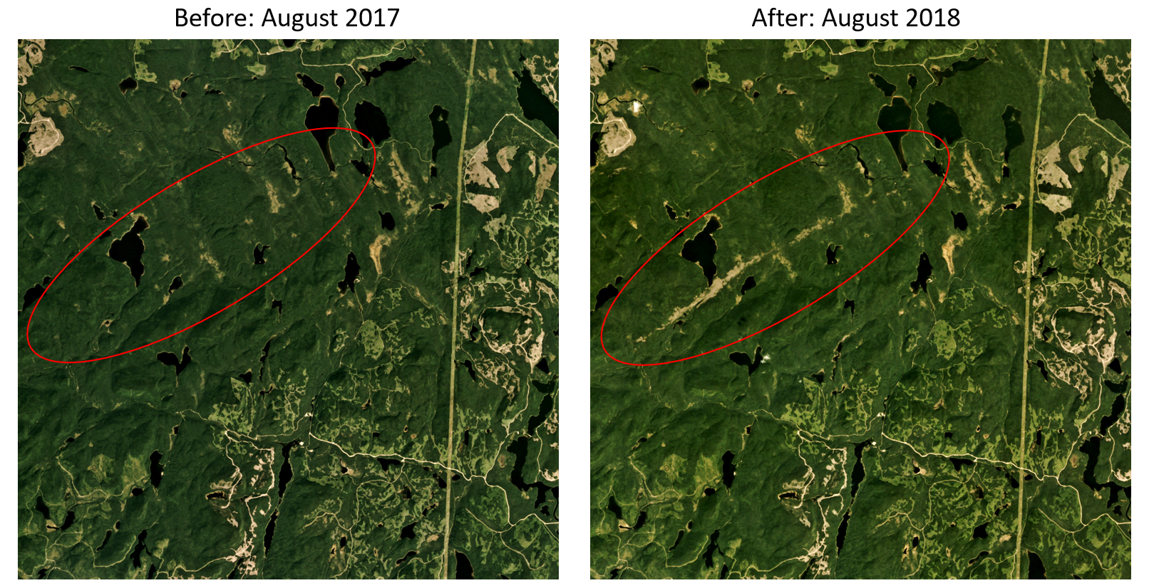
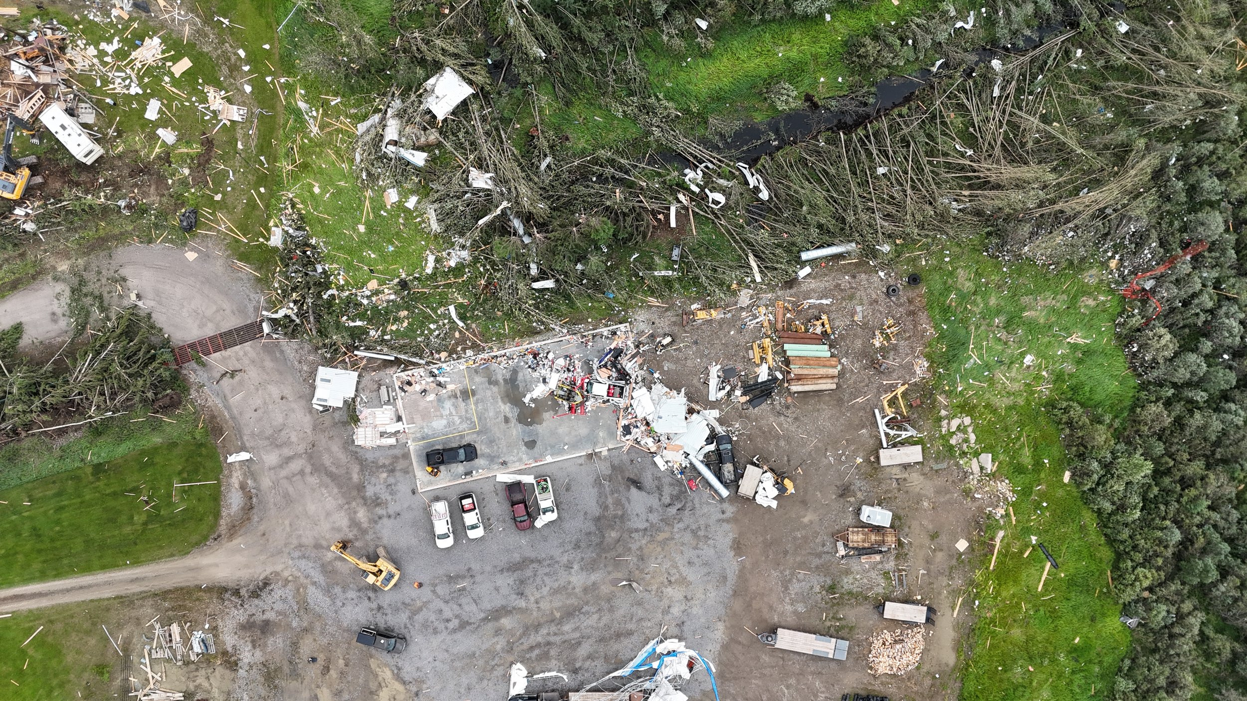
Before-and-after satellite images with the tornado’s damage path highlighted in red
The Northern Tornadoes Project (NTP) out of Western University has a clear mission: detect every tornado across Canada. However, due to Canada’s enormous size and extensive forest cover, tornado damage often happens in remote areas far from communities, where it may go unreported.
To find these undocumented tornadoes, researchers previously conducted endless hours of manual reviews of high‑resolution satellite images. In 2024, they combed through over 3.2 million km² of forested land, an effort that took roughly 300 person-hours. At present, NTP researchers need several months to finish this work as visual fatigue sets in after just 3-4 hours of scanning.
To accelerate the search, NTP researcher Daniel Butt, a PhD candidate in software engineering, developed an AI assisted satellite review tool. The system compares pairs of satellite images taken one year apart (Planet Labs August imagery) and uses machine learning to flag areas where trees have been damaged in a way consistent with tornadoes or downbursts.
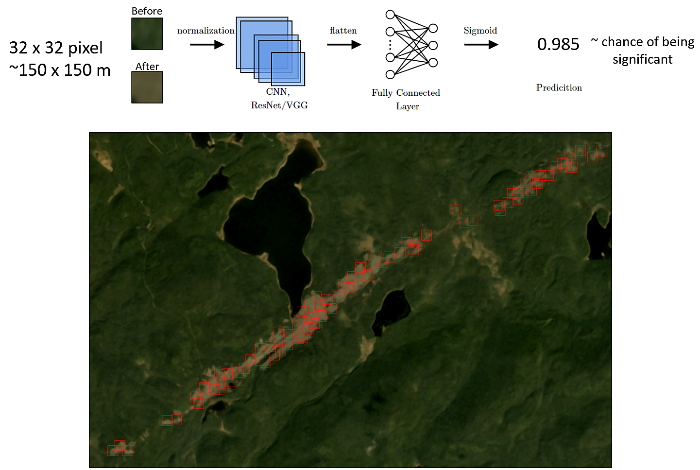
Diagram of a convolutional neural network model used to predict patches of tree damage.
First batch of Tornadoes:
A bit of history: these five newly confirmed NTP tornadoes mark the first cases identified using AI-assisted satellite scans of tree damage in forested regions. The tool was first tested in Northern Ontario, east of Lake Superior, where its findings were then manually confirmed and documented. Four of the tornadoes (one rated EF2) occurred on July 28, 2025, and the fifth on August 16, 2025.
Event summaries, a regional map, and satellite imagery highlighting the detected tree damage are included below.
Date: July 28, 2025 – 1:25 AM
Location: Whitefish Lake, ON (south of White River)
Rating: EF2
Details: Winds near 190 km/h. Track about 9.5 km long and up to 670 m wide.
Date: July 28, 2025 – 1:35 AM
Location: McMaster Lake, ON (south of White River)
Rating: EF1
Details: Winds up to 145 km/h. Track about 4.8 km long and 510 m wide.
Date: July 28, 2025 – 3:45 AM
Location: Hellyer Lake, ON (northeast of Chapleau)
Rating: EF1
Details: Winds up to 145 km/h. Track about 7.2 km long and 350 m wide. Same storm also spawned the Oscar Lake tornado.
Date: July 28, 2025 – 3:55 AM
Location: Ridley Lake, ON (northeast of Chapleau)
Rating: EF1
Details: Winds near 145 km/h. Track about 4 km long and 250 m wide.
Date: August 16, 2025 – 8:50 PM
Location: Abbott Lake, ON (northwest of Sudbury)
Rating: EF1
Details: Winds near 145 km/h. Track about 5 km long and 350 m wide.
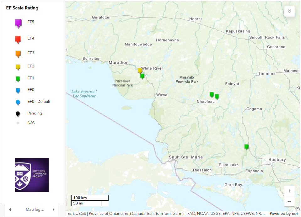
A regional map highlighting the five newly confirmed tornado locations identified using AI-assisted satellite review.
Key steps in the process include:
- Acquiring images: Obtain two sets of late‑summer satellite images over the same area, one year apart, from Planet Labs.
- Filter out noise: Use Government of Canada land‑cover maps to exclude non‑forested zones and Planet Labs’ cloud-masks to remove clouds from the imagery.
- Compare the difference: Analyze the red band of the “before” and “after” images to highlight where vegetation has changed.
- Run the model: Feed 32 × 32 pixel patches into a convolutional neural network trained to recognize tornado or downburst damage.
- Review flagged areas: Only review areas with a high probability of damage, dramatically reducing the time needed for manual scanning.
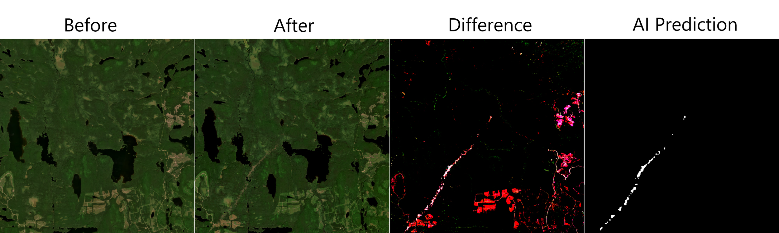
Before-and-after satellite images (Planet Labs, 4.7 m) of the Lac Pedro tornado. The “difference” image highlights changes caused by the storm, and the AI prediction shows areas where tree damage is most likely.
Early tests of this proof‑of‑concept tool have already revealed many potential tornado tracks across Canada that were missed by manual searches. NTP scientists are now verifying these candidates in the field and refining the model to reduce false alarms.
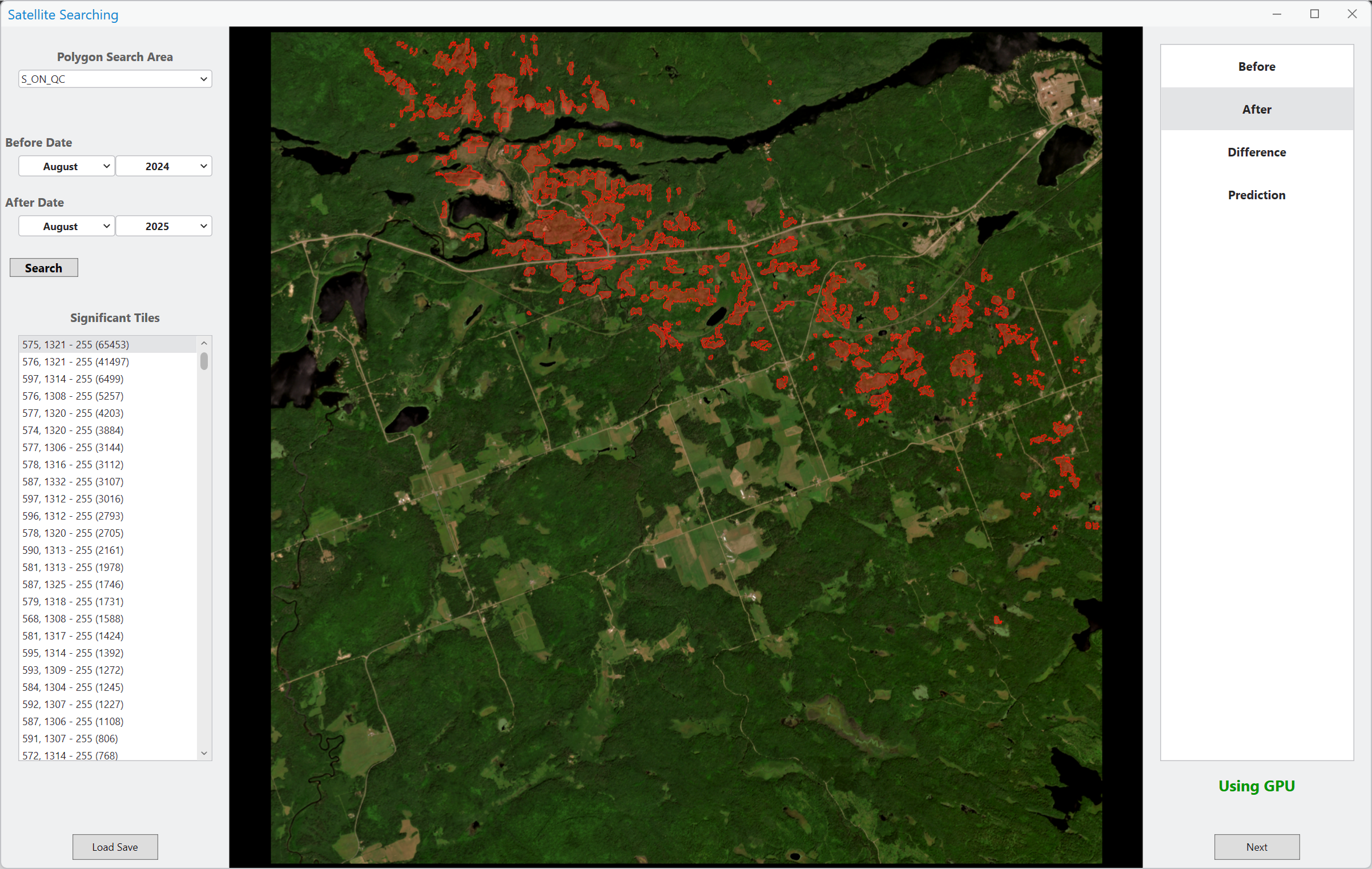
Screenshot of the satellite search software. Red highlighted areas show where the model detected significant tree damage with high confidence.
This AI assisted approach promises to help NTP achieve its goal of mapping every tornado, even those hidden in Canada’s vast forests. By automating much of the search, researchers can focus their efforts on the most promising locations and respond to severe weather reports more quickly.