Ontario: Environment Canada Forecasting Snow, Strong Winds, Cold, and Possible Freezing Rain Risk This Week
/Environment Canada meteorologists are forecasting the potential for accumulating snow, strong wind gusts, and significant cold for parts of Ontario on Tuesday. Additionally, they’re mentioning the potential for a fairly widespread freezing rain event on Friday. However, confidence is low regarding Friday at this point.
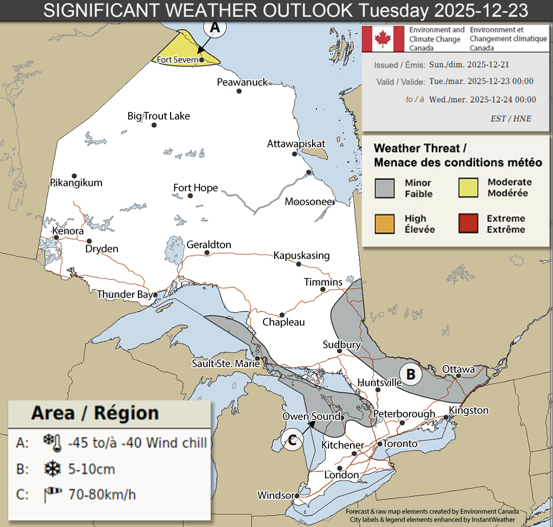
Tuesday, December 23rd, 2025
NOTE: CLICK OR TAP THE IMAGE TO OPEN A VERSION YOU CAN ZOOM
Location A: Fort Severn in Northwestern Ontario
Hazard: Cold (-40c to -45c wind chill)
Timing: Monday night into Tuesday morning
Impact(s): Risk of hypothermia and frostbite if outside for long periods without adequate protection.
Impact level: Moderate (2/4)
Confidence Level: High (3/4)
“Cold wind chill values between -40 and -45 are expected.”
Location B: Portions of northeastern, eastern, and central Ontario
Hazard: Snow (5-10cm)
Timing: Tuesday morning into the evening
Impact level: Moderate (2/4)
Confidence Level: Low (1/4)
“Snowfall amounts of 5 to 10 cm are possible. At this time, the track and timing of
the low passing through the area are still uncertain.
Possible difficult travel conditions. Snow covered and slippery surfaces such as roads and walkways.”
Location C: Areas east of Lake Superior, Lake Huron, and Georgian Bay
Hazard: Wind
Timing: Tuesday afternoon into the evening
Impact(s): Loose objects may be tossed
Impact level: Moderate (2/4)
Confidence Level: Moderate (2/4)
“Strong winds from the northwest gusting up to 80 km/h are possible.”
NOTE: CLICK OR TAP THE IMAGE TO OPEN A VERSION YOU CAN ZOOM
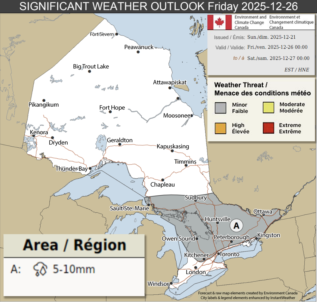
Friday, December 26th, 2025
NOTE: CLICK OR TAP THE IMAGE TO OPEN A VERSION YOU CAN ZOOM
Location A: Portions of northeastern and southern Ontario
Hazard: Ice
Timing: Friday
Impact(s): Possible icy surfaces such as roads and walkways. Broken tree branches from ice build-up.
“A low pressure system is expected to bring an area of freezing rain to portions of northeastern and southern Ontario. There may be 5 to 10 mm of ice accretion in areas affected by the main freezing rain band. However at this time, the track and timing of the low pressure system is quite uncertain.
Confidence is too low in the extended range to assign a weather threat level above minor. Impacts may reach moderate or greater. Watch for future updates.”
The exact track and timing of the low pressure system remain quite uncertain, meaning the freezing rain threat zone may shift in future forecasts.
NOTE: CLICK OR TAP THE IMAGE TO OPEN A VERSION YOU CAN ZOOM
In Summary
Snow and strong winds will impact much of southern, eastern, and central Ontario on Tuesday, with snowfall totals of 5-10 cm possible and winds gusts possibly reaching 70-80 km/h near Lake Huron and Georgian Bay.
Far northwestern Ontario will experience significant cold temperatures, with wind chills between -40c and -45c near Hudson Bay.
Friday brings an increasing risk of freezing rain across parts of south, eastern, and central Ontario, along with northeastern Ontario 5-10 mm of ice accretion will be possible. However, the forecast confidence remains fairly uncertain at this time as we’re several days away.
More details ASAP!


