
Pre-Christmas Major Snowstorm to Deliver a Wintery Blast to Saskatchewan With Up to 25-40cm and Blizzard Conditions Possible on Tuesday
/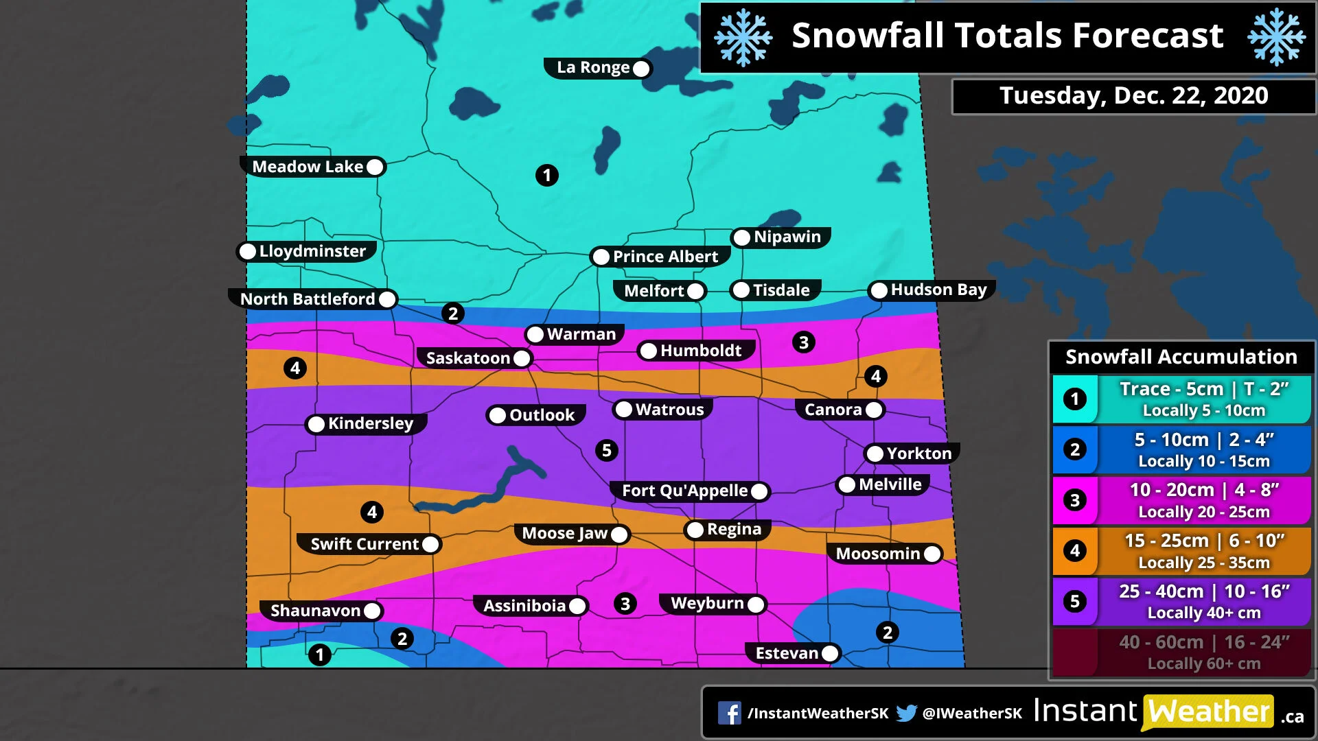
A significant winter storm is set to deliver a heavy dumping of snow to parts of Southern and Central Saskatchewan just a few days before Christmas. The hardest-hit regions from Kindersley through to Yorkton has the potential to pick up between 25-40cm of snowfall accumulation by the end of the day on Tuesday. Strong wind gusts between 60-80km/h will also be associated with this system which combined with the heavy snow, could result in blowing snow and blizzard conditions in some areas late Tuesday.
The first bands of snow will enter the western part of the province along the Alberta border just around midnight and spreading eastward through the morning on Tuesday. We expect the worst conditions will occur through Tuesday afternoon and early evening along with those strong wind gusts picking up and creating near-zero visibility out on the roads. Non-essential travel should be avoided during this time as highway closures are quite likely and you may become stranded.
Snowfall will continue late Tuesday and even into early Wednesday morning but most of the expected snowfall accumulation will be on the ground by the end of the day on Tuesday. Flurries will linger into Wednesday morning especially near the Manitoba border with conditions rapidly improving overnight Tuesday.
As we mentioned above, the heaviest snowfall totals will be found from the Alberta border around Kindersley, eastward through the Fort Qu’Appelle and Yorkton area. Current indications suggest that this area has the potential to see snow totals between 25-40cm by the time the snow tapers off late Tuesday or Wednesday morning.
Other areas including Swift Current, Moose Jaw and Regina can expect final snowfall accumulation between 15-25cm with localized amounts near 30cm. Lesser amounts are expected to the north and south with Saskatoon, Shaunavon and Weyburn seeing between 10-20cm of snowfall accumulation. The southeast and southwestern corners of the province will see less than 10cm of accumulation including Estevan.
In the wake of the storm, very cold air will flow into the province pushing temperatures to near or below -20°C across Saskatchewan by Wednesday morning. Wind chills will make it feel like -35°C or colder in some areas Wednesday morning and again on Christmas Eve morning near the Manitoba border. Temperatures will warm up as we head into Christmas morning with morning lows in the upper negative single digits or low teens. With these cold temperatures expected, it’s near-certain that Saskatchewan will see a White Christmas this year - our updated White Christmas outlook will be out on Tuesday.
