
Hurricane Teddy Update #1
/Forecast Updated at September 20th @ 10:20 AM
Forecast Valid September 20th @ 11 AM
Forecaster: James Follett

Good Sunday Morning! This is Instant Weather Tropical Update #1 on Hurricane Teddy as it heads for Bermuda and Atlantic Canada.
As of the 5 AM update on Hurricane Teddy, Winds have dropped to now 105 MPH making it a Strong Category 2 Hurricane and it is now jogging to the WNW at 12 MPH and is expected to turn more Northward later today. The pressure has risen substantially to 964mb up from 958 just 3 hours ago.
Teddy's evolution for the next few days appears to be a tale of 3 troughs. Upper-level westerly flow associated with the first upper-level trough, affecting the storm now, is the most likely reason why the hurricane's structure has degraded and has taken on a slightly sheared appearance. Teddy will begin to encounter the 2nd trough, a deep frontal system approaching from the west, later today and that should cause the hurricane to turn north. This interaction should steer the center of Teddy east of Bermuda, but tropical storm impacts from either the large hurricane, the frontal system, or both are still likely Sunday evening through Monday night.
All indications are that Teddy will then continue generally northward and merge with the frontal system, nearing Nova Scotia as an extratropical cyclone early Wednesday. Teddy's maximum winds will likely decrease sharply after it becomes post-tropical, as shown by all the intensity guidance, but its gale and storm-force wind radii will likely increase at the same time. The cyclone should turn northeastward as the 3rd trough, another mid-latitude system, approaches from the west. Teddy could be absorbed by that feature in as soon as 120 h, though this is not explicitly shown in the forecast at this time. The spread in the track and intensity guidance is quite low and confidence in both aspects of the forecast is high. There is a little more uncertainty in the wind radii evolution, but it is clear that Teddy will produce strong winds over a wide area of the northwest Atlantic during the next couple of days.
The extent of 12-foot or higher seas associated with Teddy continues to increase. See the Key Message below regarding swells caused by the hurricane.
We now know more on the highest most likely impacts it will have on the Province of Nova Scotia and the rest of Atlantic Canada.
Hurricane Teddy’s Impacts On Nova Scotia

Highest threat of Hurricane and/or Tropical Storm conditions are Flooding & Wind damage. Where in many areas of the province sustained Tropical Storm force winds of 60-70 km/h will Gust up to 100-110 km/h and with lot’s of foliage on the trees, that will put more stress on the trees and will then break and/or fall, and these can fall on cars, power lines creating power outages. But also flying debris such as roof shingles, house sidings, signs, flower pots, Patio furniture, trampolines the biggest one!.
If you have any small objects that are light that can blow away and create damage, you have until Tuesday Morning to get it done! Things that should be brought in or taken down includes Flower pots, Patio furniture, Trampolines, etc.
Along with objects, it is very important that you cut down any potential tree branches that are old or look weak that has the potential too fall down on the house, or car, this can be done up until Monday Night.
After noon time on Tuesday, time will be up and all bets are off, as Tropical Storm force winds arrive shortly after noon hour, Rain at times heavy begin over Eastern NS and South Shores Tuesday late Morning between 9 and 11 AM.
The next threat then is the flooding, which will be a very big threat for much of Eastern NS and Northern NS with up to 100 mm is expected, further South the amounts are less where only up to 30 mm will fall regardless of how much rain falls, torrential tropical downpours can cause flash flooding, as well as Street, coastal and urban flooding. It is very important that you clean up the storm drains on your street next to you, flooding becomes fast all the time when storm drains are clogged and water cant fall down. This must be done before Tomorrow Night.
Other types of flooding includes Coastal flooding, low lying areas near the water can get severe flooding from Storm surge, and to make things worst is that this storm comes on a night of Astronomical High Tide. Big waves of over 12ft, giant surfs, storm surge and the high heavy rain amounts will cause extreme flooding threats for communities near the water all up and down the coast of Nova Scotia, with exception to Bay of Fundy where land interaction and opposite wind direction will create a lower flooding threat.
Beach erosion is also very likely along all ocean facing Beaches.
Tornadoes… As with all Tropical Cyclones, there is the risk of Tornadoes because of the circulation. how ever the threat for Tornadoes are very low as there will not be much convection as storm weakens.
Hurricane Teddy Wind Field

Correction: Tues, Sept 22nd*
The current track of Teddy puts it heading for extreme Eastern Cape Breton, around Sydney. However as the Hurricane tracks North on it’s way over the next few days and transitions to Post-Tropical the Wind Radii begins to expand, so even though the center of storm may be far offshore, the Tropical Storm Force winds and Tropical Storm conditions will spread all through Southern, South Shores and Western Nova Scotia beginning Tuesday Morning into Wednesday Night.
For Northern Nova Scotia & Cape Breton, The storm will pass very close and will intensify just a little, producing Hurricane force winds that may reach the area, never the less the area will still see Tropical Storm force winds sustained.
Power outages very likely!
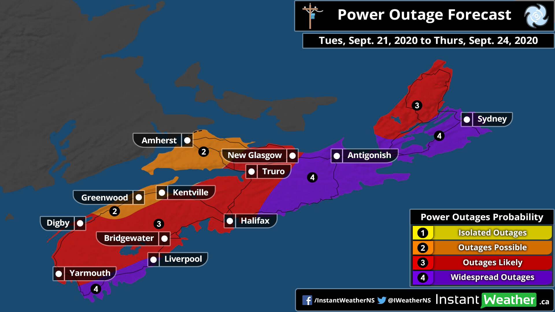
Correction: Tues, Sept 22nd*
Wide spread Outages can be expected through Southern Shores, Northern NS, & Eastern Cape Breton.
Outages that are likely or very likely covers a big area of the province. much of Tri-Counties up through Halifax and Northern NS into New Glascow as well as Western Cape Breton, for Eastern NS, and parts of Kings and Annapolis Valley will see some possible Outages through Wednesday Night.
Hurricane Teddy Rainfall Intensity Forecast

Rain will start Early to Mid Tuesday morning, Moderate rain will come from the East, a more lighter rainfall for Western side of the province, as well Cape Breton.

By the time we get into the Evening and Overnight hours, we’ll see Moderate to Heavy rain much of province except for Northern and Cape Breton, where very Heavy rainfall is expected, look at 20+ mm/hr rates

By Wednesday, the rain and heavy rain continues especially if in Eastern, Central & Northern parts of the province. By time we are at mid day Wednesday we will have very heavy rain that have rates of 30+ mm/hr, this is where you 70-100+ mm totals come from.

By Wednesday Evening into the Overnight, much of the province will see the rain shut off, however some light to Moderate rain continues over Western Cape Breton from Antigonish to Sydney.

As the system pulls away heading for the Island of Newfoundland, still will be a few left over showers over Eastern Cape Breton.
Thunder Storms Likely Tuesday & Wednesday!
Now with Heavy rain, and a lot of Energy and this is a tropical System.. How about Thunderstorms? yup they’re a possibility!
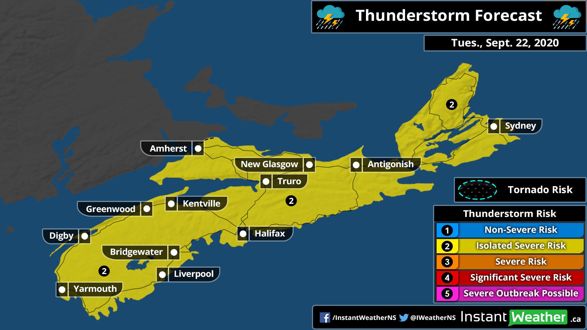
On Tuesday, the entire province has a Isolated Severe risk of Severe Thunderstorms.

Now on Wednesday, as the storm pulls North, we’ll see a Severe risk of Thunder storms and Isolated in Cape Breton!
Teddy’s Impacts!

Correction: Tues, Sept 22nd*
The biggest impacts will be in Cape Breton as that is where the center will track. but much of the province will see a big impact! From Yarmouth to Antigonish expect Significant Impact, This also includes Digby and Greenwood!
Then Kentville, Amherst, New Glascow, Truro will a lesser impact, but still a Moderate Impact to winds and rain, but not so much storm surge.
Teddy’s Rainfall Through Thursday Morning.

Correction: Tues, Sept 22nd*
For Southern, Southern Shores, Annapolis Valley, Kings counties, much of Eastern Cape Breton. You will see the least amount of rain, do to the fast speed, so a wind issue rather than rain. However that is not to say you won’t get anything!! 15 to 30 mm is in the forecast, and there could be some local amounts of 30-40 mm . For Halifax, Halifax Metro, Truro, Amherst. Look at 25 to 50 mm with locally 50 to 70 mm. This is where the Flooding threat is expected. For New Glascow and and surrounding areas, 40 to as much as 75 mm! and you could have locally some amounts approaching 100 mm. Antigonish and remaining areas, look for the heaviest rain, to create severe flood risk, 75 to 125 mm of rainfall with locally some amounts approaching 125 mm.
Teddy’s Winds Through Thursday

Correction: Tues, Sept 22nd*
A wide swath of the province will see winds between 80 and 100 km/h Gusts. Cape Breton is exception, where they will see the most winds! of Winds Gusting to 110+ km/h , least winds can be found in Western sections such as East of Kentville, Truro, Kentville. winds Gusting 80 to 95 km/h which is Tropical Storm force, anything over 60 km/h is Tropical Storm force.
Teddy’s Hazards

Damaging Wind risk is fairly high! along with Severe weather and Travel can be quite Significant. Flood risk is Moderate to High and the Confidence on the forecast is a bit better now at 75-100%, which is pretty good, however still a few things needs watching that can change the system.
What to do! and How to Prepare!
The Storm is now only about 48 hours away, and with the very high likely hood of a dangerous direct impact on the province. It’s time to prepare! and Go over the Emergency Preparations
What to do before the Hurricane arrives!:
Get water, Bread, can food that will last up to 3 days.
Buy a Generator!
take down old, weak large tree branches that has potential to fall down on your car or house.
clean up near the storm drains, make sure there is plenty of room for the water to flow down.
What to Have during the storm and what to go over:
. A flash light
Batteries
Weather Radio
canned food
An emergency kit
Gas ready in car
Money
Generator for long lasting Power Outages
You Should be going over the Hurricane kit and Emergency plan with the family.
Go over what to do before, During & After the Hurricane or Tropical Storm.
Have a Emergency Aid kit! and go over the items with the Family
Have an Evacuation Hurricane Plan!! For those living near the coast, where severe flooding and beach erosion is very likely, Coastal evacuations may be needed, Go over what to do in the case of an evacuation
AND MOST OF ALL….
Stay Calm!!!
Pandemic rules still apply!!
Keep a distance of 6ft!
Wear a Mask!!
Wash your hands frequently!
Be Safe! and have a great Sunday Morning
Next Update is at 4 PM
