
Destructive Wind Storm Possible Across Southern Ontario on Saturday With Gusts Up to 90-120 km/h; Risk of Freezing Rain for Ottawa Valley
/
A deepening low-pressure system from Colorado will move across Ontario on Saturday bringing with it the threat of potentially damaging to destructive wind gusts to much of Southern Ontario. On the bright side, this system will usher in a brief shot of mild air with temperatures reaching into double digits before a cold front sweeps across the region later in the day putting an end to this. There will also be the threat of freezing rain primarily through the Ottawa Valley and into Northeastern Ontario during the morning hours on Saturday.
We’re expecting the strongest wind gusts to start to pick up around the noon hour with Southwestern Ontario and continue eastward through the afternoon. There is some disagreement amongst the models on the exact strength of these gusts with conservative estimates of around 80-90km/h inland and near 95-100km/h along the shorelines. While more aggressive models point towards what could be the strongest wind storm we’ve seen in years for this region with widespread gusts from 90-105km/h and up to 120km/h for the northeastern shorelines of Lake Ontario and Erie. Regardless of what happens, the winds will be still quite strong and may result in many power outages across Southern Ontario. Be prepared for some wind damage and bring in anything that could be blown away. Secure your holiday decorations!
We have a particular concern for those regions right along the northeastern shoreline on Lake Ontario and Erie due to the very strong southwesterly winds which could gust up to 120km/h. Aside from the potential wind damage, this will likely cause very high waves on the lakes and result in some shoreline flooding. Locations such as Port Dover, Port Colborne and Prince Edward County should be prepared for flooding in areas that have a history of wind-related flooding.
The strong wind gusts will continue into the evening especially for Eastern Ontario. However, we should start to see them die down somewhat later in the evening and as we head into the overnight hours. In addition to the strong wind, we’re also expecting some heavy rainfall with the latest model data pointing to widespread totals between 10-20mm. There is currently a rainfall warning in effect for a wide swath of Southern Ontario, but we’re just not seeing the widespread potential for more than 20mm at this time. In fact, a few models point towards this system underperforming in terms of rainfall with less than 10mm in some areas. Now, there is the risk for some non-severe thunderstorms through Southwestern Ontario and into the Golden Horseshoe which could lead to localized higher rainfall total.
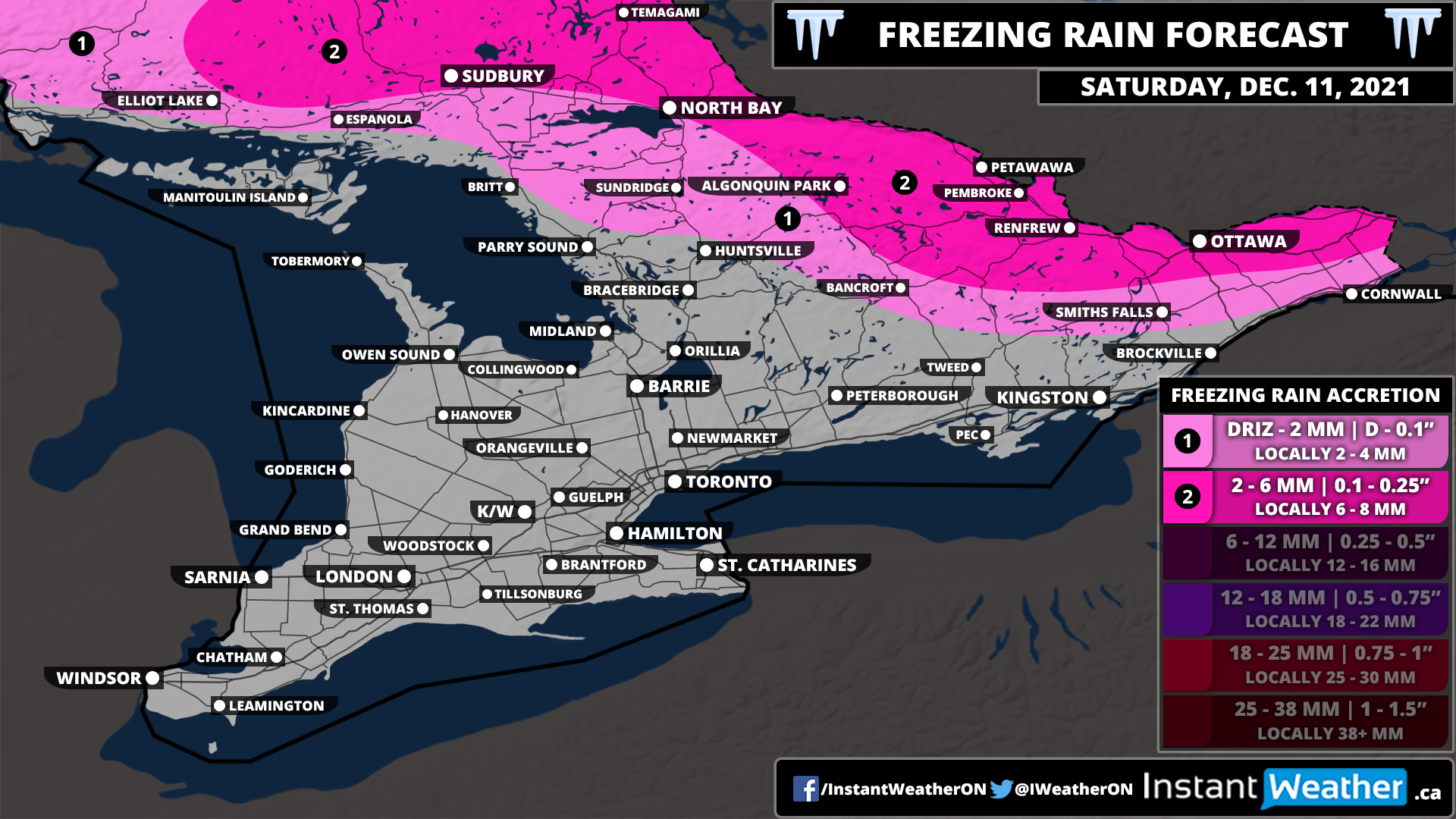
While most of Southern Ontario will see a rapid rise in temperatures overnight and early Saturday morning as a result of some milder air, the same can’t be said for Northeastern Ontario and parts of the Ottawa Valley. It appears that the cold air will be a little more stubborn in this area during the morning which will allow for the risk of freezing rain. It could linger for several hours before the warmer air finally wins over and is able to cause the temperature to rise above the freezing mark.
Ice accretion ranging from 2-6mm can’t be ruled out for locations such as Ottawa, Renfrew, Petawawa, North Bay and Sudbury which could lead to icy road conditions and some power outages. Depending on how fast an existing ice accretion is able to melt, this may add an additional variable to the power outages risk later in the afternoon as the strong wind gusts move in Eastern Ontario. The freezing rain risk will come to an end by the early afternoon hours as it switches over to regular rain.
