
Second Wind Storm in a Week for Southern Ontario on Thursday and Could Be Stronger Than Saturday’s Wind Storm
/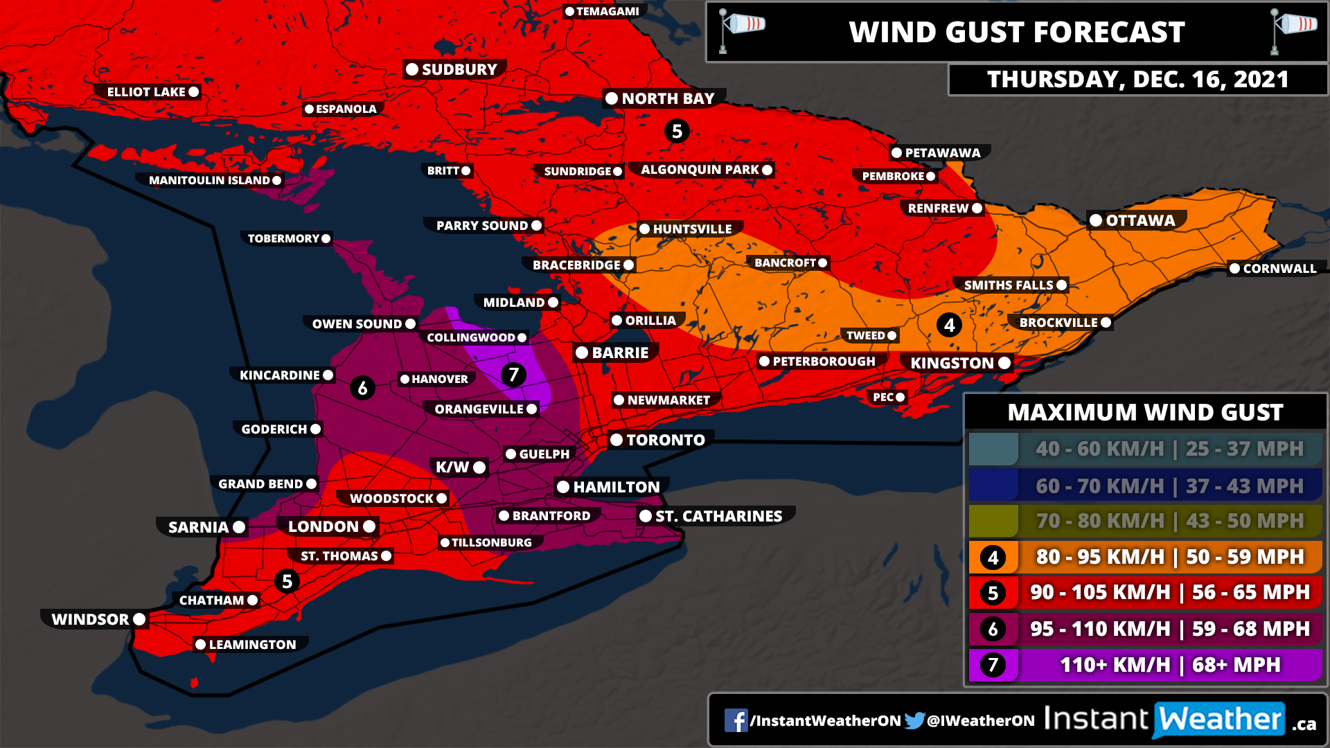
This has certainly been a weird start to winter across Southern Ontario as instead of snow and wintery weather, we’re tracking the potential for the second destructive wind storm in a week throughout much of Southern Ontario. The impacts of this second wind storm will vary depending on location, but it appears the damaging wind gusts will be way more widespread than Saturday and also affect parts of Central, Eastern and Northern Ontario which didn’t see the full brunt of the wind on Saturday. We’re quite concerned about the wind damage and power outage potential based on the latest data which has further increased the strength of the expected wind gusts.
The latest data shows widespread wind gusts exceeding 90km/h even further inland away from the shorelines. We could see gusts exceed 100km/h through the higher elevations northwest of the GTA, along Lake Huron and into the Hamilton and Niagara region. The Blue Mountains, Collingwood and Orangeville are consistently being highlighted in the data as seeing gusts potential exceed 110km/h. Wind gusts will be weakest through portions of Central and Eastern Ontario, but they’ll still see quite strong wind gusts ranging from 80-95km/h.
We will see the wind begin to pick up during the early morning hours of Thursday for Southwestern Ontario as the deepening low-pressure system that spawned a line of destructive storms across the US Midwest moves into Northern Ontario. The wind gusts will continue to get even stronger later in the morning with the worst conditions expected after sunrise on Thursday. For Eastern Ontario, the stronger gusts will occur during the late morning and early afternoon. We should see the wind gusts slowly die down later in the day however they will remain quite strong going into the evening ranging from 60-80km/h
Aside from the wind, we are looking at another unseasonably warm day with temperatures reaching into the low double digits. It’s possible some areas may break their temperature record. There is also a slight risk of some non-severe thunderstorms later on Thursday as a cold front sweeps across Southern Ontario. This will usher in some colder air bringing temperatures back to near or below the freezing mark overnight Thursday.

In Northern Ontario, the impact of the wind storm will be mostly focused on the Lake Superior shoreline and into Northeastern Ontario. Locations including Thunder Bay, Marathon, Wawa and Sault Ste. Marie may see gusts approach 100km/h during the morning hours. The southern portion of Northeastern Ontario will see gusts ranging from 90-105km/h with less of an impact the further northwest you go in the region. Northwestern Ontario isn’t expecting much in terms of wind gusts from this system. However, Northwestern Ontario will see some heavy rainfall with between 20-40mm possible by the end of Thursday in locations such as Atikokan, Sioux Lookout and Armstrong.
