
Significant Blizzard To Bring Up to 50cm of Snow and 90+km/h Wind Gusts to Nova Scotia Late Sunday Into Monday
/
A strengthening low-pressure system is set to track up the East Coast bringing widespread snowfall between 10-20cm on Sunday to the same areas that got pummeled by the powerful Nor’easter earlier in the week like New York and New England. This same system will also take aim at Nova Scotia with the system intensifying as it tracks just off the coast. As a result, we expect Nova Scotia to be on the cold side of this system and the predominant precipitation type will be snow. There might be some mixing along the coast with ice pellets and some freezing rain although that is very dependent on the system tracking closer to the coast and at the moment it looks unlikely.
Most of the precipitation will come down within a 12 hours timeframe across Nova Scotia mainly overnight into Monday morning. Rapid snowfall accumulation is expected during this time with hourly snowfall rates exceeding 5cm. Combined with strong wind gusts over 90km/h, this will likely create very hazardous conditions with near-zero visibility and drifting snow.
The first bands of precipitation will each the Yarmouth and Liverpool area starting around the dinner hour on Sunday and spreading northward throughout the evening. We expect the worst conditions will be found around midnight and into early Monday morning. The snow will begin to taper off from the south just after sunrise and continuing to move out throughout the day on Monday. Cape Breton will be the last to clear out with flurries lingering into the early evening on Monday. Everything should be done by the end of Monday as the system moves off into Newfoundland.
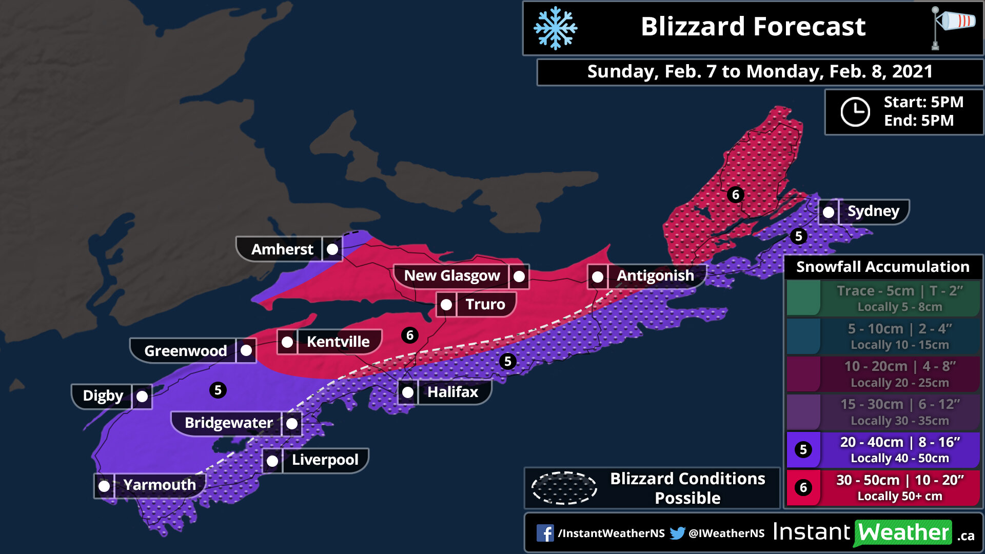
When it comes to total snowfall accumulation from this storm, we’re looking at widespread accumulation ranging from 20-40cm with locally up to 50cm. For those further inland, less precipitation is expected so generally, this would lead to lower snow totals, but colder temperatures (-1 to -2°C compared to -3 to -4°C inland) will also be found in these same areas. As a result, the slightly colder temperatures would mean a higher snow ratio (the amount of snow created from equivalent liquid precipitation; a higher ratio implies more snow for the same amount of precipitation) so further inland locations such as Kentville, Truro and New Glasgow could actually see between 30-50cm of accumulation. This may change should the system tracks further offshore than expected although it’s what the data currently shows.

The heavy snowfall will also be accompanied by very strong wind gusts, especially along the coast. Wind gusts in those areas including locations such as Liverpool, Halifax and Sydney could exceed 90km/h mainly during the early morning hours on Monday. Further inland, the wind will be weaker although gusts will still peak at over 70km/h (over 80km/h for Cape Breton). This will likely create blizzard conditions for several hours particularly closer to the coast although it may extend quite far inland with the potential for blowing snow for the rest of the province that doesn’t quite reach blizzard criteria. The strong wind gusts will end later in the morning on Monday around the noon hour, but gusts between 60-80km/h may continue across Cape Breton into Tuesday.
If you can, just stay home starting Sunday evening until midday Monday when conditions should begin to improve. Roads throughout the province will be snow-covered with strong wind gusts causing near-zero visibility so travel will become near impossible at the height of this storm. Stay safe!
