Messy End to the Beautiful Week Across Southern Ontario With Heavy Rain, Significant Freezing Rain and Strong Wind Gusts on Friday
/Mother Nature has given us quite the treat the past week with extremely mild temperatures that we normally see towards the end of spring or even early summer. Although as we end of the week we’re looking at quite the messy system to affect Southern Ontario with mainly heavy rainfall and strong wind gusts on Friday. For areas further north through parts of Central Ontario and Northeastern Ontario, the main concern will be the potential for significant freezing rain along with some wet snow starting early Friday morning and continuing throughout the day. This will result in icy driving and even the threat of power outages in the hardest-hit regions.
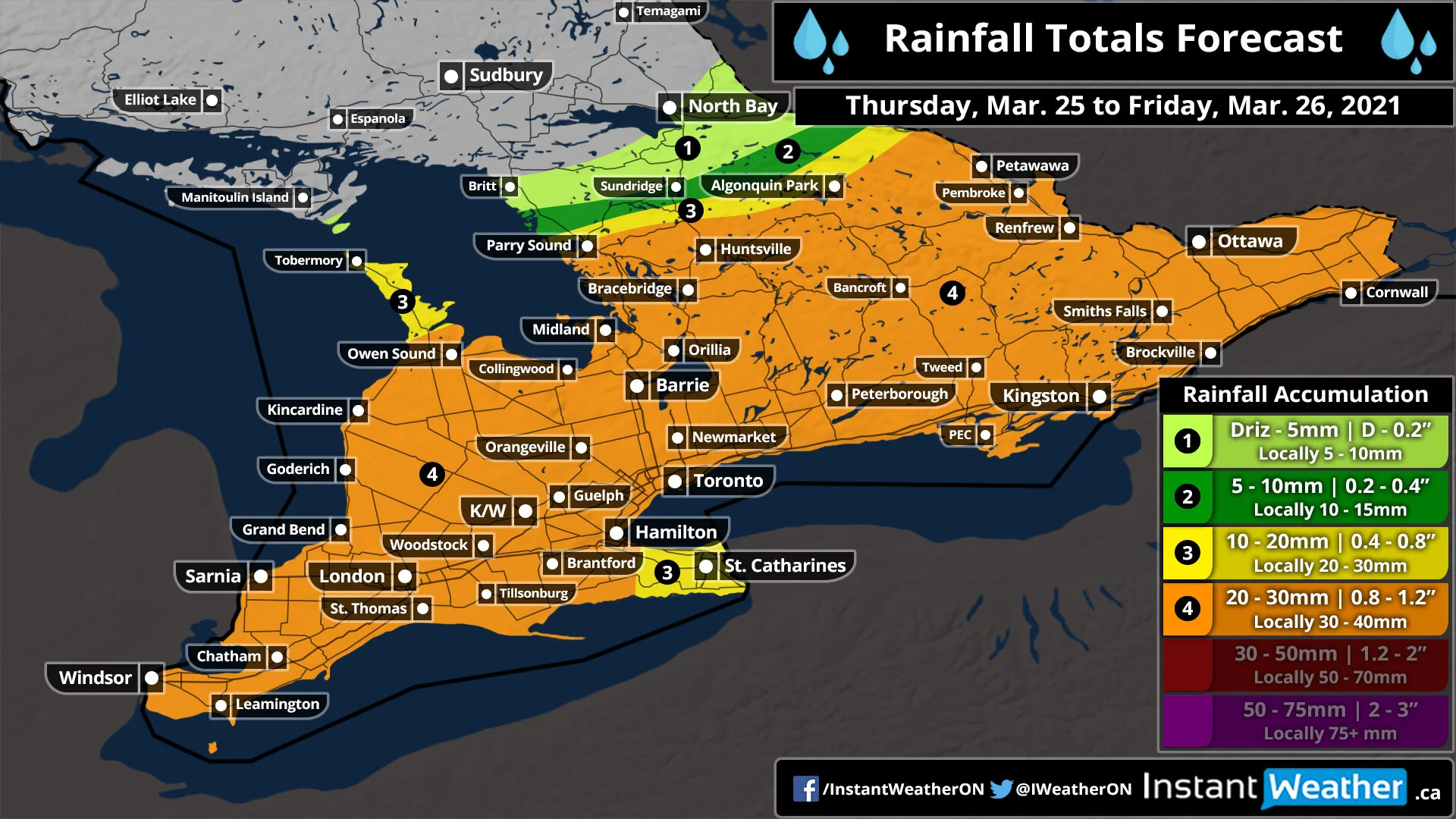
Precipitation will begin to work into the province just before the midnight hour starting as rain along the Lake Erie shoreline. The heaviest rain is expected through Friday morning and afternoon and will start to become less intense later in the day. We will also see colder air flood into the province during the evening on Friday which may result in a few hours of wet snow in some areas although no accumulation is expected outside of Central and Northeastern Ontario since the ground will still be quite wet and warm. We expect total rainfall accumulation to range from 20-30mm in most areas although localized amounts in the heavier bands of precipitation may approach 40-50mm.
Precipitation will come to an end by late Friday as the system moves out over Quebec. It should also be noted that the rain will be accompanied by strong to damaging wind gusts approaching 70-80km/h in much of Southern Ontario. Wind gusts over 90km/h are possible for the northeastern shoreline of Lake Ontario and Erie including the Niagara Region and Prince Edward County. A separate wind map will be issued tonight for Friday morning.
There will also be a wintery component to this system although that will be focused on far northern sections of Central Ontario extending into parts of Northeastern Ontario. A heavy band of freezing rain will develop early Friday morning stretching from the Bruce Peninsula through areas north of Muskoka and into Algonquin Park. The hardest-hit regions could see around 6-12mm of ice accretion although the limited timeframe of this event should keep overall impacts from being too significant. Surrounding regions including Parry Sound and North Bay could see a few hours of freezing rain although it will likely be more of a messy mix including snow, ice pellets and regular rain depending on the temperature. Later in the day, we expect a switch over to heavy wet snow particularly for the North Bay/Powassan area where it’s more elevated. Some data suggests accumulation of over 15cm although we believe this is overdone and much of it will likely come down as ice pellets or melt on contact. Still expecting around 6-12cm of accumulation in the hardest-hit regions, but again the exact amount is unclear and is highly dependent on precipitation type and temperature.
In the wake of this system, we expect temperatures will be much colder than we’ve seen the past week. Overnight temperatures on Friday could drop below the freezing mark in many areas through Southern Ontario. Daytime highs throughout the weekend won’t be super chilly staying within the mid to upper single digits although it’s unlikely we’ll see many double-digit highs (maybe for Extreme Southwestern Ontario).


