
Weekend Snow Squalls Could Bring Up to 15-30cm of Snow to Parts of Southern Ontario by Monday Morning
/
NOTE: You can click on the map to open a zoomable image which will be easier to read.
While we have been treated to a rather mild start to November, it was only inevitable that the word many in the traditional snowbelts of Southern Ontario dread will make its way into the weather conversation. The arrival of cold temperatures this weekend combined with the relatively warm waters of Lake Huron and Georgian Bay is expected to kick off the lake effect snow season.
Scattered precipitation is currently ongoing across parts of Southern Ontario coming down in the form of light rain along the shorelines and even wet flurries in areas that have already approached the freezing mark. As this disturbance exits the region in the coming hours, we expect to see the development of localized, but intense snow squalls off Lake Huron and Georgian Bay as early as the midnight hour.
Based on the northwesterly flow expected to dominate overnight and into Sunday, it appears the focus of the lake effect bands will be on the southeasterly shorelines of Lake Huron and Georgian Bay. The worst conditions will be found during the early morning hours of Sunday when the temperature will be the coldest resulting in optimized accumulation. Our focus will be on two main squalls with the Lake Huron one stretching from between Goderich to Grand Bend and inland to just north of London. The Georgian Bay squall is expected to stay closer to the shoreline affecting the Meaford, Collingwood, Wasaga Beach and perhaps the City of Barrie at times. Strong wind gusts ranging from 30-60km/h combined with the heavy snow will result in very poor road conditions and maybe even some road/highway closures in the hardest-hit regions. Consider postponing any non-essential travel on Sunday.
As we head into the late afternoon and early evening on Sunday, we expect to see a temporary shift in the wind direction to a more WNW flow which would push the squalls to the north. Regions like Kincardine, Listowel, Midland and Orillia will see some brief bursts of heavy snow as the squalls stall over the area for a few hours late Sunday. The squalls will retreat south overnight as they slowly weaken by Monday morning with flurries lingering throughout the early part of Monday, but should be mostly finished by the afternoon.
Here is an advertisement so we can pay the bills:

NOTE: You can click on the map to open a zoomable image which will be easier to read.
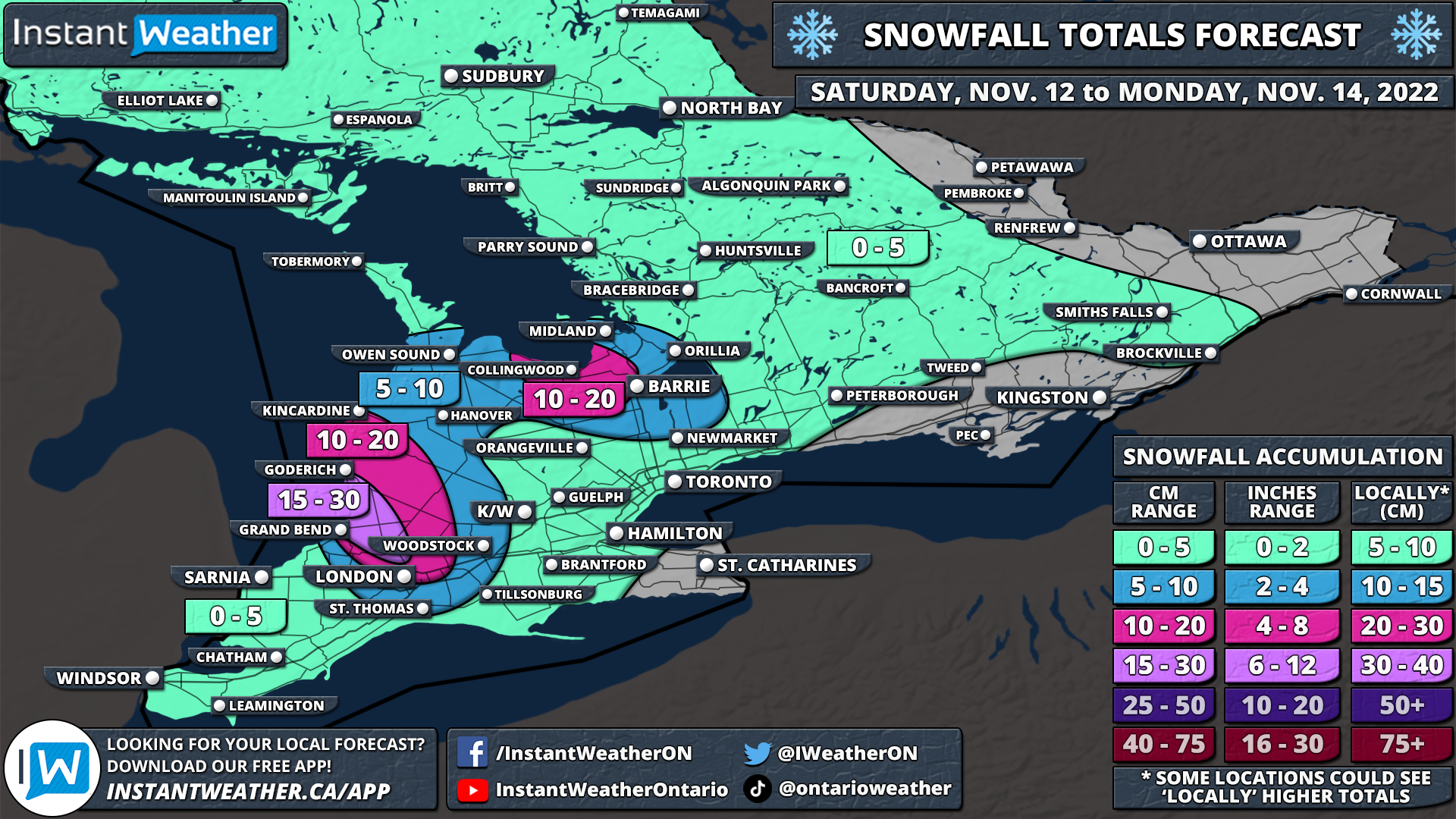
By Monday morning, we could be talking about some localized significant snowfall totals in parts of the snowbelts. It looks like the ‘winner’ (or loser, depending on your perspective) of this snow squall event will be a small zone to the northwest of London off the Lake Huron shoreline. Locations including Goderich, Clinton, Grand Bend, Exeter and Lucan could pick up between 15-30cm of snowfall accumulation over the next 36 hours. Keep in mind that lake effect snow is traditionally very localized and while one location can get dumped on, a location down the road may see just a dusting of snow so this isn’t guaranteed. Furthermore, temperatures are very close to the freezing mark and could even rise briefly above freezing during the day which could compress some of the accumulation and make it look like less has fallen.
Surrounding the hardest-hit region, we are looking at snowfall accumulation generally ranging from 10-20cm for locations east of Lake Huron and southeast of Georgian Bay including London, Wingham, Kincardine, Collingwood, Wasaga Beach, Angus and Barrie. A few locations, particularly around Georgian Bay could overachieve these amounts and pick up closer to 25-30cm, however, the confidence isn’t high enough to merit the addition of a 15-30cm zone on the forecast map. Even further away, we are expecting around 5-10cm of snow for regions including the rest of Simcoe County, into Northern York Region and much of Southwestern Ontario. Everyone else in Southern Ontario could see a few rounds of scattered flurries throughout the day on Sunday, but we aren’t expecting any accumulation, especially with temperatures right near the freezing mark
Here is another advertisement so we can pay other bills:
