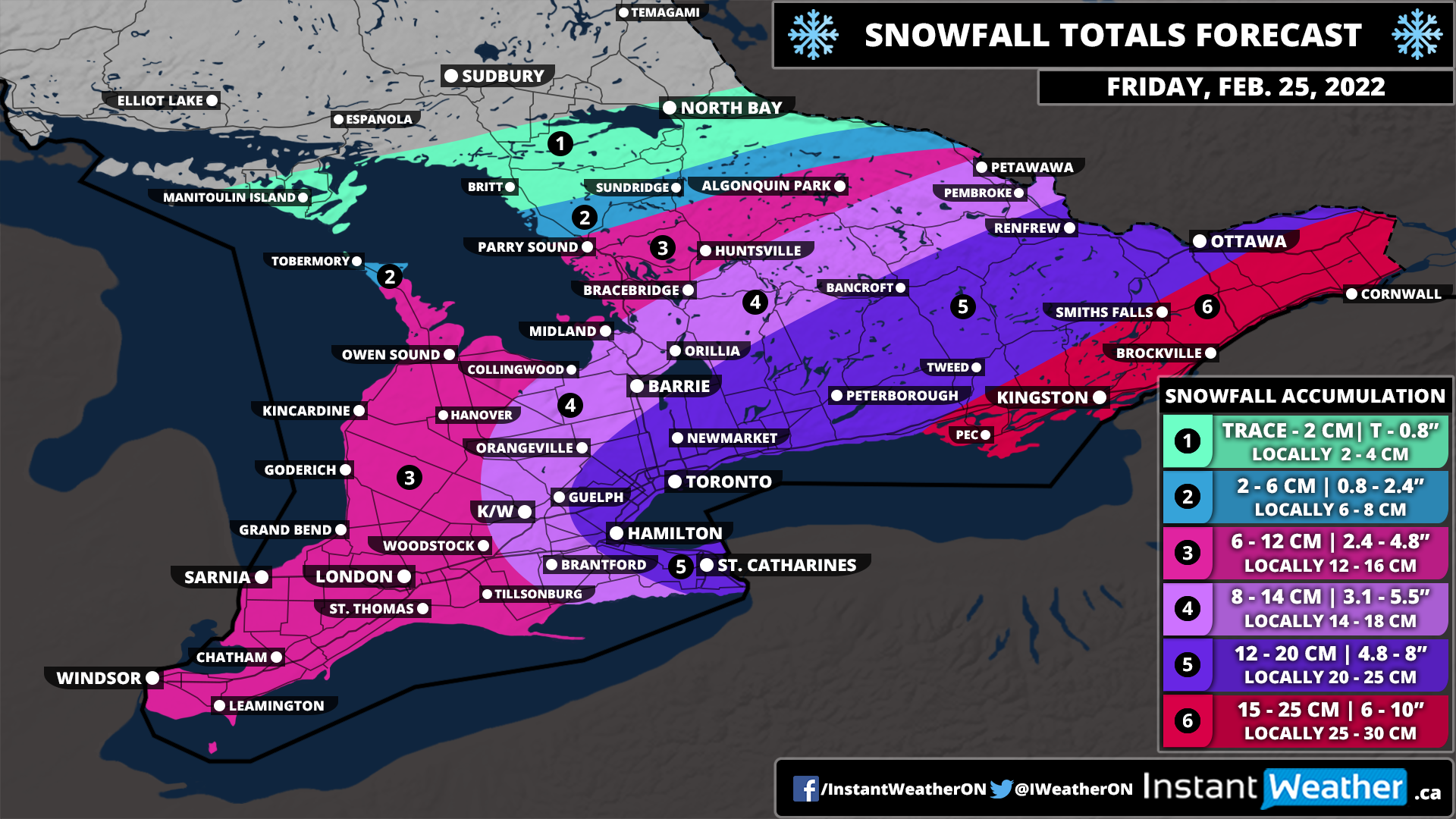
Southern Ontario: Snowfall Outlook for Friday, February 25, 2022
/Forecast Discussion
We are monitoring a system that now appears poised to bring more snowfall than previously indicated on Friday. The latest data has boosted the snow totals across Southern Ontario with widespread 10-15cm and even upwards of 20cm for parts of Eastern Ontario.
The first bands of precipitation have already reached the southwestern part of the province. Light to moderate snow will continue to spread to the northeast throughout the predawn hours on Friday and intensify through the GTA by 2-6 am and Central/Eastern Ontario by the late morning.
The timing of this event couldn’t be any worse for those commuting on Friday morning with the heaviest snow occurring around sunrise. This event will be more of a persistent moderate snowfall with hourly accumulation ranging from 1-3cm. As a result, travel will still be heavily impacted, but road crews should be able to keep up for the most part and shouldn’t be overwhelming.
Blowing snow could be an issue as 40-60km/h wind gusts combined with this light powdery snow are a recipe for reduced visibility. Based on the timing, school bus cancellations can’t be ruled out mainly in the more rural school boards as they tend to be more sensitive to weather conditions. See our snow day forecast here. Travel according to the conditions and if possible, delay any travel until later in the day. This will be a fairly fast-moving snowfall event as we expect it will taper off by the late morning for Southwestern Ontario and mid-afternoon in Eastern Ontario.
The biggest change compared to our initial forecast is the expected snowfall total. We have moved most regions up a level on our legend except for Southwestern Ontario. The highest totals will be found through Extreme Eastern Ontario including Kingston, Brockville and Cornwall with between 15-25cm of snow possible. The 12-20cm zone is now quite expansive including the rest of Eastern Ontario, parts of Central Ontario and around the Golden Horseshoe.
Lower amounts are expected for Southwestern Ontario which should top out at somewhere around 6-12cm. Totals will decrease even further to the northwest with Northeastern Ontario only expected to pick up a few centimetres of fresh snow if anything at all.
It should be mentioned that this event does appear to have a significant lake enhancement element associated with it. What does this mean? Well, snowfall accumulation with these events tends to have quite an uneven distribution. For example, one location could see 20+cm of snow while just down the road there is less than half of that. Don’t be surprised to see some locations overachieve the forecast, but we believe it’s more realistic to focus on the overall general totals.
Conditions will rapidly improve later in the day on Friday leading into what appears to be a quiet weekend. May see some scattered flurries on Sunday for Central and Eastern Ontario, but nothing more than a few centimetres.


