
Significant Severe Thunderstorm Risk (Wed, Jul 20, 2022)
/
NOTE: You can click on the map to open a zoomable image which will be easier to read.
Wednesday, July 20th, 2022:
Above is our preliminary forecast map, which could very well end up being the map we continue with later today. Widespread severe thunderstorms are expected to develop in southwestern Ontario beginning most likely in the late afternoon and evening hours. If storms develop early enough and get to full strength in southwestern Ontario by 5-6pm, several tornadoes would not be out of the question and perhaps even one or two strong tornadoes. Large hail (1-3cm), damaging wind gusts (110km/h+), frequent lightning, and isolated flooding are all on the table. Environment Canada has even issued a “High” risk and we talk more about that further down the page.
IMPORTANT: Please, take a deep breath. Please, do not panic. This isn’t the 1980’s where you didn’t find out about a tornado until hours after it happened. Our team will be live with you every step of the way on Wednesday via YouTube, Facebook, Twitter, and Twitch tracking every developing storm and notifying those in the path of any rotation, tornado reports, damaging winds, and large hail on our free app Instant Weather and via our premium Text Message Alerts (if you don’t have PayPal, you can also subscribe to our text messages directly on our website).
Here is another advertisement so we can pay other bills:
Environment Canada has posted a “High” risk forecast map with fairly similar regions to our forecast map and a mention of “Damaging wind gusts to 110 km/h and toonie sized hail are the main threats, however a few tornadoes are also possible. A significant tornado cannot be ruled out.”
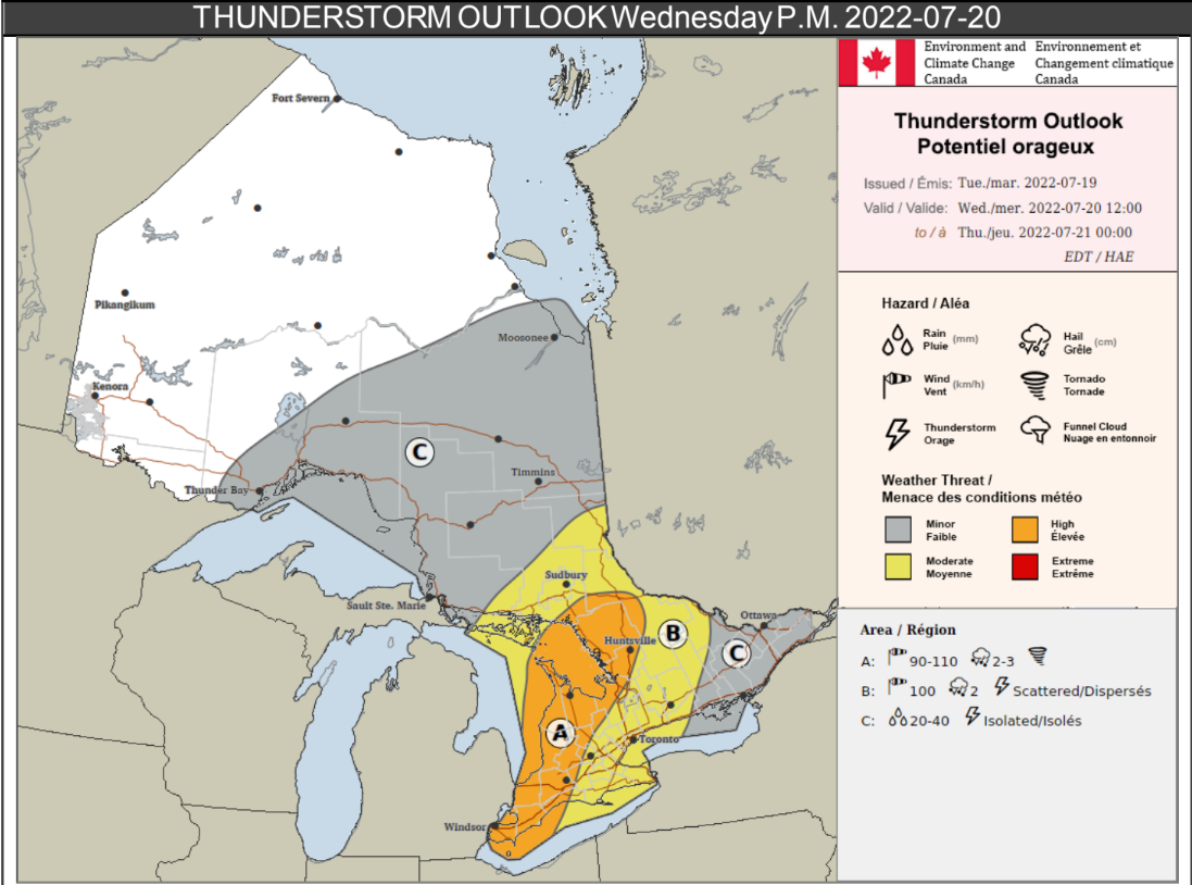
NOTE: You can click on the map to open a zoomable image which will be easier to read.
In their description they wrote:
Area A:
Location: Portions of southwestern and central Ontario, as far north as Lake Nipissing.
Impacts: Very strong wind gusts can damage buildings, down trees and blow large vehicles off the road. Power outages are likely. Large hail can damage property and cause injury.
Confidence: Medium.
Description: Severe thunderstorms are expected in the afternoon and will move west to east through the area. Damaging wind gusts to 110 km/h and toonie sized hail are the main threats, however a few tornadoes are also possible. A significant tornado cannot be ruled out.
Area B:
Location: Portions of southwestern, central and northeastern Ontario, as well as the GTA.
Impacts: High winds may toss loose objects or cause tree branches to break. Power outages are possible. Large hail can damage property and cause injury.
Confidence: Medium.
Description: Scattered severe thunderstorms are possible. The main threats with these storms will be wind gusts to 100 km/h and nickel sized hail. The eastern extent of this threat area is uncertain at this time.
Area C:
Location: Northeastern and eastern Ontario, as well as areas north of Lake Superior.
Impacts: Localized flooding in low-lying areas is possible. Isolated lightning strikes.
Confidence: Medium.
Description: Isolated thunderstorms with heavy downpours are possible.
Long story short slightly longer; please have a plan if you’re in the path of these storms. It could get quite dangerous and the more prepared you are, the less intimidating it will be. Be safe!
