
Northern Ontario: Snowfall Outlook for Friday, February 18, 2022
/Forecast Discussion
No heavy snowfall (10+cm) is expected in the forecast region on this day.

No heavy snowfall (10+cm) is expected in the forecast region on this day.

Inclement weather isn’t currently expected in the forecasted region on this day.

A snowstorm is currently ongoing across Southern Ontario and is expected to bring widespread snowfall accumulation of between 15-25cm by Friday morning. This will likely result in a big impact on the morning commute with widespread school bus cancellations or school closures expected.
Based on the timing of this event, the higher chance of a ‘snow day’ will be through Eastern Ontario as the snow will still be falling around 6 am which is when the decision to cancel school buses is made. It’s hard for us to see how any school buses will be able to safely operate in this region on Friday so there is a 90% chance of a snow day.
Further west, it will really come down to how fast road crews are able to clear up the snowfall accumulation from overnight. Blowing snow will also be a concern during the morning which would also factor into the decision. The more rural school boards outside of the GTA have a 75% chance as they are fairly likely to see bus cancellations, but it’s not guaranteed like in Eastern Ontario.
While conditions will be similar, we’ve given the GTA a 50% chance as these school boards tend to have a higher threshold for cancellations due to being less reliant on bussing. And Southwestern Ontario will see the snow come to an end several hours earlier so we aren’t as confident that road conditions will still be bad enough to prompt cancellations. As such, they also have a 50/50 chance of seeing cancellations on Friday.
NOTE: We are aware that some school boards have a PA Day on Friday. Based on feedback, we have decided to create our forecast without considering any PA days as not every school board even in the same region follows the same schedule. This ensures that no one is left out of our forecast. If you have a PA Day tomorrow, consider it a guaranteed snow day and enjoy the weather!
If there are any cancellations tomorrow morning, you can be sure we’ll be up bright and early beginning at 6 AM with our bus cancellations live blog to keep you updated.
Disclaimer: Instant Weather has zero authority when it comes to bus and school closures. It is completely up to the school boards, bus companies, and local authorities as well as being up to parents to decide what is best for their children. This is simply our best guess based on our forecast. Also note that due to the current pandemic, some school boards have changed their policies on school bus cancellations. Some will continue the school day in a virtual format should there be school bus cancellations - check with your local board for more details.
No heavy snowfall (10+cm) is expected in the forecast region on this day.
Inclement weather isn’t currently expected in the forecasted region on this day.

An impactful winter storm is set to affect Southern Ontario beginning Thursday. The main event doesn’t get underway until later in the day so that shouldn’t be an issue when it comes to school buses on Thursday. However, icy road conditions from the temperature drop and the risk of freezing rain during the morning and afternoon could be sufficient enough to merit some bus cancellations.
The best chance to see bus cancellations is the Sarnia and Windsor area where a Winter Storm Warning from Environment Canada talks about a freezing rain risk in the morning which is usually enough to result in cancellations. Not to mention that the freeze-over will occur during the morning too compared to later in the day for others. As such, there is a 90% chance of a snow (or ice) day in this zone. The London area has a similar warning so we’ve given them a 75% chance.
Outside of this region, we have fairly low confidence in exactly which boards will choose to cancel so we’ve gone with a widespread 50% chance of a snow day. The only exception to this is the more urban school boards including Toronto, Niagara and Ottawa which tend to have a higher threshold to cancel buses or close schools and have a 25% chance. The school boards that cover the Parry Sound/North Bay and Bancroft area tend to cancel buses more frequently so we’ve bumped those areas up to a 75% chance. This is simply based on the track record in these regions. We aren’t saying that conditions will be particularly worse compared to other regions. It’s just that we’re more confident in those boards to be more proactive and cancel school buses.
Bus cancellations and school closures are expected to be more widespread for Friday as the snowfall overnight will make for quite a mess for the Friday morning commute.
If there are any cancellations tomorrow morning, you can be sure we’ll be up bright and early beginning at 6 AM with our bus cancellations live blog to keep you updated.
Disclaimer: Instant Weather has zero authority when it comes to bus and school closures. It is completely up to the school boards, bus companies, and local authorities as well as being up to parents to decide what is best for their children. This is simply our best guess based on our forecast. Also note that due to the current pandemic, some school boards have changed their policies on school bus cancellations. Some will continue the school day in a virtual format should there be school bus cancellations - check with your local board for more details.

After a fairly mild day across Southern Ontario on Wednesday, that will be coming to an end as an impactful system is set to dump up to 15-30cm of snow between Thursday and Friday. Earlier data indicated a more northern track which would have resulted in a fairly expansive freezing rain and even an ice storm threat. It appears the storm will indeed track further south with the colder air encompassing more parts of our region and making this a snowstorm for most locations. The Niagara region along with Prince Edward County and Kingston are the only exceptions to this which is still on track to see several hours of freezing rain.
The worst conditions are expected during the late afternoon on Thursday starting in Southwestern Ontario and continuing through the evening and early Friday morning. A very intense band of snow will work its way through the Sarnia, London, K/W, GTA, Peterborough and Ottawa corridor late Thursday which could bring hourly snowfall rates between 4-8cm for several hours. As a result, rapid snowfall accumulation is expected and will feel very reminiscent of the blizzard that dumped over 50cm of snow in the span of 6-8 hours exactly one month ago to the data as of Thursday.
The moisture associated with this system won’t be as intense as what we saw a month ago so snowfall rates exceeding 10cm are unlikely. Along with mixing and ice pellets being more prevalent with this system will help reduce potential accumulation. However, the immediate impact of this storm probably won’t be that different from what we saw last month because it’s impossible for road crews to keep up with the rapid accumulation. The long-term impact shouldn’t be as significant since 15-30cm of snow is the maximum that we’re going with which is around half of what the last storm delivered for many areas. It should allow for a faster and more efficient cleanup.
There is also the threat of a few hours of blizzard conditions with 30-60km/h wind gusts and very intense snowfall rates. Now, it might not meet the official criteria for a blizzard according to Environment Canada which requires blizzard conditions that last 4 hours or longer, but a few hours can still make travel near impossible during that time. Travel should be avoided starting late Thursday and if you can, stay home on Friday as many roads will likely still remain snow-covered. School bus cancellations and school closures are almost certain for Friday and some areas could even see them on Thursday due to the risk of freezing rain early in the day.


TIP: You can click on either timeline graphic to open a zoomable version of the graphic.
We’ve already begun to feel the impacts of this system with heavy rainfall occurring Wednesday evening and will continue into Thursday morning. General rainfall totals will range from 10-25mm across Southern Ontario (Note: we have only included rainfall totals occurring after 6 am in the graphics above - although almost everyone will see heavy rain late Wednesday and overnight).
The first threat associated with this winter storm will play out just after sunrise on Thursday as cold air starts to flood into Southern Ontario from the northwest. This will push temperatures below the freezing rain starting with Central and Southwestern Ontario during the morning on Thursday. Due to the previous rainfall and melted snow, it’s quite likely that we see icy conditions developing on roads so be sure to drive very carefully on Thursday.
The cooldown thankfully appears to be more gradual over the span of 3-6 hours instead of a rapid drop so a traditional flash freeze is unlikely. This will continue to spread to the southeast throughout the day reaching the GTA by the early afternoon and Eastern Ontario by the mid to late afternoon.
As the cold air causes temperatures to drop, we will also see the rain slowly transition over to an hour or two of freezing rain and ice pellets before snow takes over. The exact switch over for each region is outlined in the regional graphics above, but it will occur sometime during the late morning and afternoon depending on your location.
The snow will likely start off quite light and there might even be a short break during the afternoon on Thursday before the second push of moisture moves into the region by the dinner hour. This second round will come in the form of snow as we expect most areas to have cooled down enough. A slower cool down could result in more ice pellets mixing in from Windsor, through the GTA and into the Ottawa Valley during the early evening. Depending on the extent of this slowdown, it could significantly reduce the potential snow totals in those regions so keep in mind the forecasted totals are conditional on that.
For the Niagara region and a small area around Kingston, it looks like the colder air could get stuck which would allow for the development of a fairly extensive band of freezing rain. Significant icing is possible for the aforementioned regions starting late in the afternoon and continuing past midnight. This of course will depend on the exact temperatures and if it’s slightly warmer it could come down as regular rain or slightly colder would mean more ice pellets or snow.
As mentioned, this wave of precipitation will bring very intense snowfall rates of 4-8cm per hour during the evening hours. That combined with the strong wind gusts will result in localized blizzard conditions and blowing snow. It will only last for 2-3 hours max, but during that time it will be almost impossible to travel anywhere so PLEASE stay home if you can late Thursday.
Conditions will improve overnight and early Friday morning as the snow becomes less intense and the system moves out of the region. We do expect a significant impact on the Friday morning commute as it’s unlikely that most roads will be cleared of snow by then so continue to stay home if you can.

By the time the snow tapers of early Friday, we are looking at widespread snowfall accumulation ranging from 15-30cm including Windsor, Sarnia, London, K/W, Toronto, Peterborough and Ottawa. A few localized totals could exceed the 30cm mark especially if temperatures end up slightly colder and allow for higher snow ratios. Mixing along the southern edge of this zone including Windsor and Hamilton could also decrease snowfall totals if the switchover is delayed.
For those along the Lake Erie shoreline and into the Niagara region, we are looking at between 5-15cm of snow along with the freezing rain threat with the snow coming predominantly early Friday morning after the switchover. Totals will also drop off further norther with between 10-20cm of snow extending from Goderich through Barrie, Southern Muskoka and Pembroke. The Bruce Peninsula and Parry Sound/Northern Muskoka are can expect around 5-15cm (likely closer to the lower end). Little to no impact is expected for Northeastern Ontario as this will be contained to Southern Ontario.
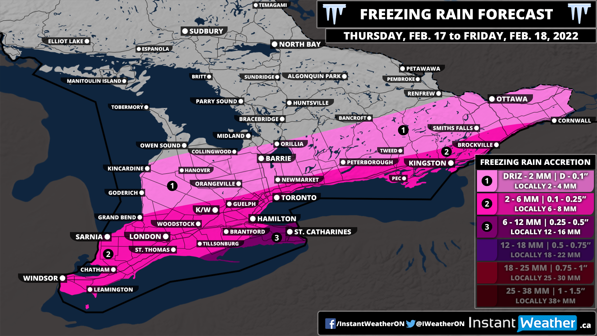
The focus of the freezing rain will be on the Niagara Region including St. Catharines and Niagara Falls late Thursday and Friday morning. Total accretion here could range from 6-12mm with locally as much as 15mm if it ends up lasting longer than expected. Kingston and Prince Edward County will likely end up somewhere around 4-8mm so we haven’t included them in the higher zone. The rest of the affected regions can expect a few millimetres of ice accretion during the switch over mid-day Thursday.
Keep in mind that this isn’t a typical freezing rain event which is usually followed by a warm-up and any ice to quickly melt. This event will be followed by another drop in temperature later on Friday and will stay below the freezing mark going into next week. Power outages are possible in the affected region and could even continue to linger into the weekend as the ice adds continued stress on power lines and trees. Be sure to charge up all your devices and be prepared for power outages.
No heavy snowfall (10+cm) is expected in the forecast region on this day.
Inclement weather isn’t currently expected in the forecasted region on this day.

No heavy snowfall (2+cm) is expected in the forecast region on this day.

We’re in for a wild rollercoaster ride over the next few days across Southern Ontario when it comes to the weather. This is thanks to a complex system that is expected to become even stronger as it pumps Gulf of Mexico moisture into our region between Wednesday and Friday.
It will all begin early Wednesday morning as we see a steady rise in the temperature bringing all of Southern Ontario well above the freezing mark throughout the day on Wednesday. We are talking about fairly unusual temperatures for this time of the year with daytime highs potentially approaching the upper single digits. It’s possible we may break some temperature records on Wednesday as the record high for most locations range from 3-9°C which is quite likely to be surpassed on Wednesday.
The rise in temperatures across the region will also be accompanied by some very strong wind gusts developing Wednesday morning and continuing into the afternoon. We expect the strongest gusts will be found along the Lake Huron shoreline and through the Niagara Escarpment stretching from Collingwood down into Hamilton. Damaging wind gusts ranging from 90-110km/h are possible in those regions which could result in power outages.
The rest of Southwestern Ontario, around the Golden Horseshoe and east of Georgian Bay can expect wind gusts to max out at around 85-95km/h with power outages also possible. Eastern Ontario and Central Ontario will see slightly lower wind gusts maxing out at somewhere between 80-90km/h, but that certainly isn’t weak so expect some minor wind damage even though they aren’t in the strongest zone.

The wind storm threat should die down as we head into the evening on Wednesday and the first wave of moisture from the system moves into Southern Ontario. This first round will predominately come down in the form of rain as temperatures will remain mild overnight. Those in Northeastern Ontario could see some snow instead of rain as the warmer air likely won’t reach that far north with 5-10cm of snow possible.
Overall we are looking at widespread rainfall accumulation by the Thursday morning/afternoon to range from 10-30mm across Southern Ontario. It appears that Southwestern Ontario and a pocket extending from Georgian Bay and southeastward into the Kingston area will see the highest totals between 15-25mm (locally up to 30mm).
There is some disagreement in the exact intensity and distribution of the moisture with this first round which would affect the overall rainfall totals. That’s why our map might look a little unusual with the random yellow zone including Barrie and Toronto in the middle of all the orange. Some models suggest that a ‘dry slot’ will develop over this region which would result in slightly lower rain totals.
We are looking at less rain through Northeastern Ontario along with Eastern Ontario along the Quebec border. Rainfall totals here will range from 5-15mm with less than 5mm further north where snow will be a bigger issue. This amount of rain combined with a melting snowpack could result in some localized flooding so be aware of that if you live in an area prone to flooding in the spring.
Heavy rain will continue into predawn Thursday, however, a sharp drop in temperature will occur during the morning hours on Thursday starting with Southwestern and Central Ontario. This will be the biggest concern associated with the rainfall as all the moisture on roads and other surfaces will begin to freeze and create icy driving conditions. Be very careful out on the roads during the morning and afternoon on Thursday as the temperature drops. The temperature drop appears to be more gradual so we likely won’t see an official ‘flash' freeze, but the previous rainfall will likely cause issues.

As the temperature drops, this will allow for a transition over to a messy mix of winter precipitation including freezing rain, ice pellets and heavy snow setting the stage for what could be a fairly impactful winter storm. A second push of moisture will move into Southern Ontario late Thursday and last into Friday. There is some uncertainty regarding the speed of the cooldown and track of the system. If the cooldown is faster and the system pushes further to the southeast as indicated by a few models this would make this a snowstorm for Southern Ontario with minimal freezing rain as it’ll stay south of the border.
At this moment, we are going with a more northern scenario with our preliminary forecast as there is more agreement and consistency between the models that show this outcome. Just keep in mind that this is subject to change and we may have to adjust our map southward if the southern trend wins over. To the north, we are looking at heavy snow ranging from 15-30cm which will include much of Southwestern and Central Ontario along with the Ottawa Valley. Again, we may have to reduce these totals on the northern edge of our map if the moisture tracks further south. This includes Muskoka, Simcoe County and Pembroke/Renfrew which may end up closer to 5-15cm if it tracks southward.
The biggest concern for this winter storm is the potential for prolonged freezing rain including Deep Southwestern Ontario, Niagara/Hamilton and Kingston region starting Thursday afternoon and continuing into Friday morning. This area may approach ice storm level with models indicating ice accretion up to 10-15mm and locally even higher. To make matters worse, temperatures will drop even further as we head into Friday so any ice accretion will stick around and continue to cause issues when it comes to travel and the power grid. Power outages are very likely in this zone so be prepared for outages that could linger into the weekend.
Remember that freezing rain is probably the most difficult precipitation type to forecast as it requires a very specific environment to occur. A slight change in the temperature either at the ground or further up in the air could result in the ice storm not happening as we see more ice pellet, snow or regular rain instead of the freezing rain. We want you to be aware of the risk, but hope that the dynamics just don’t align and we see less freezing rain than expected.
There is a tight zone that encompasses much of the Hwy 401 corridor including London, K/W and GTA that is right on the line of seeing freezing rain or snow. It could really go either way depending on the temperature, but we expect a few hours of freezing rain during the day on Thursday before ice pellets and snow mix in by the evening. Ice accretion may range from 2-5mm followed by up to 10-20cm of snow (ice pellets could reduce these totals depending on how fast the switch over occurs).
The precipitation will come to an end by Friday morning as the system moves out of Southern Ontario. It will be followed by another cooldown pushing temperatures well into the negative teens for Friday.
We can’t emphasize this enough: this forecast will likely change! We are providing this very preliminary forecast to help you prepare and have an idea of the potential impacts. However, there is still a lot to work out especially with rapidly changing temperatures that could affect what type of precipitation we see. A more detailed forecast including snowfall and freezing rain accumulation maps along with hour-by-hour timing will be published by Wednesday evening or Thursday morning (if there is still a lot of disagreement amongst the models).
No heavy snowfall (10+cm) is expected in the forecast region on this day.
Inclement weather isn’t currently expected in the forecasted region on this day.
No heavy snowfall (2+cm) is expected in the forecast region on this day.

Inclement weather isn’t currently expected in the forecasted region on this day.

Confidence is growing in a potentially major winter storm that could have an impact on much of Southern Ontario later this week. There is still a lot to be determined including the exact precipitation type and hardest-hit locations/regions which will come down to the track and mixing line.
What we do know is that this will be an expansive system affecting almost all of Southern Ontario with some form of wintery precipitation. We expect it will begin sometime late Wednesday starting with rain with mild temperatures well above the freezing mark throughout the overnight and into Thursday morning.
This won't last long as colder air will flood into the region by early Thursday allowing for the rain to transition over to freezing rain, ice pellets and heavy snow. How fast this cooldown occurs will be key in determining the exact impact on our region. There could also be the risk of a significant flash freeze with the earlier rainfall and a rapid drop in temperature.
A second push of moisture will make its way into Southern Ontario by late Thursday continuing into Friday. Again, the exact precipitation type is unclear as it will depend on those temperatures. The two main concerns we have with this setup are the heavy snow and prolonged freezing rain potential. Starting with the heavy snow, we are looking at a swath of 15-30cm snow possible which currently appears to extend from Lake Huron and to the northeast through Muskoka and into the Pembroke/Renfrew region. Some other models show this further south bringing it into Southwestern Ontario, GTA and Eastern Ontario.
Further south, we are seeing what could be a prime environment for many hours of freezing rain starting late Thursday and lasting into Friday morning. Exactly where this line of freezing rain sets up will likely shift around as we get closer to the event. Currently, it looks like Deep Southwestern Ontario, the GTA and Eastern Ontario are at the highest risk for freezing rain. But this certainly isn't set in stone - it's important to be aware of the risk.
The dynamics with the freezing rain risk are fairly unusual where we normally see freezing rain before a major warm-up which limits the ice accretion. This won't be the case as a sharp cooldown will follow the freezing rain with temperatures remaining below the freezing mark for days to come. Prolonged impacts including power outages may continue into the weekend if this materializes.
We may have to start talking about an 'ice storm' with this event if the current data is correct but too early to say for sure. Again, lots can change so let's hope this doesn't happen as it could be very damaging.
We will continue to closely follow this and post a more detailed preliminary forecast hopefully sometime Tuesday. Stay tuned!
No heavy snowfall (10+cm) is expected in the forecast region on this day.
Inclement weather isn’t currently expected in the forecasted region on this day.


