Hurricane Lee to Make Landfall in Atlantic Canada This Weekend With Significant Impacts Expected
/Hurricane Lee is finally on Atlantic Canada’s doorstep, and the region must brace itself for a formidable weather event. The cyclone's approach brings with it a variety of hazards that impact Nova Scotia, New Brunswick, and Prince Edward Island. As Lee makes its final approach overnight, the rain has been an early precursor. The relentless tropical storm-force winds, expected to commence after midnight along Nova Scotia's South Shore, will signify the storm's arrival.
This hurricane, on its northeastward trajectory, will weaken to a Tropical Storm in the early afternoon and it is expected to make landfall in the Yarmouth County area late in the afternoon to early evening. Despite being downgraded from a hurricane, winds and rains will relentlessly pound the Maritimes, persisting well into Sunday.
Winds will be one of the main concerns with Lee. Across the Maritimes, gusts exceeding 70 km/h will sweep across the landscape. The epicentre of this windstorm will likely materialize in Southwestern Nova Scotia and Southern New Brunswick, where gusts could roar at 120+ km/h, particularly in exposed coastal areas.
The prolonged duration of these high wind gusts, combined with trees still laden with leaves and saturated soil, will likely lead to widespread power outages in the hardest-hit areas. With trees retaining their foliage, they will act as obstacles tossed around by the relentless wind, potentially bringing down power lines in their wake.
Communities must be prepared for the possibility of extended periods without electricity.
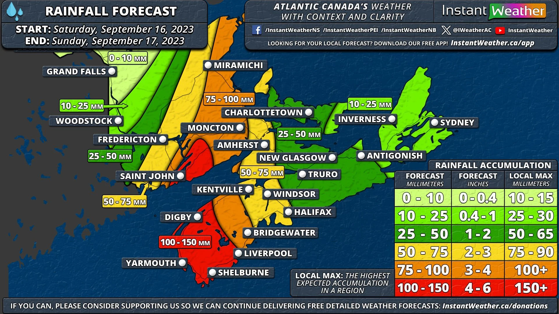
Heavy rainfall is another consequence of Hurricane Lee's arrival. The amount of precipitation varies, with the heaviest downpours concentrated around the storm's core. Closer to the center of the cyclone, rainfall totals may soar above 100 mm, exacerbating concerns about flooding. This impending deluge follows closely on the heels of heavy rains earlier in the week, amplifying the risk of flooding across the region.
The hurricane's unwelcome visit isn't limited to wind and rain. Coastal regions, especially along Nova Scotia's Southern Shore and the Bay of Fundy, face the peril of coastal flooding driven by storm surge. During high tides, waters could surge up to 2 meters above normal high tide levels, menacing coastal communities.
The Bay of Fundy, with its already dramatic tides, may witness waters surging 3 meters above the norm. Adding to the peril, wave heights along the South Shore could exceed 6 meters, exacerbating the coastal flooding situation.
In the face of Hurricane Lee's relentless onslaught, residents of Atlantic Canada must prioritize safety, heed official warnings, and prepare for a strong storm. While Lee is not as strong as Fiona from last year, it remains a storm that needs to be taken seriously.


