
Yet Another Messy Winter Storm & Damaging Wind Gusts on the Way for the Maritimes This Weekend
/
NOTE: YOU CAN CLICK ON THE MAP TO OPEN A ZOOMABLE IMAGE WHICH WILL BE EASIER TO READ.
Over the last few days, we’ve been tracking a potent low-pressure system that has been making its way through the United States and has been cutting through Southern Ontario Friday, bringing heavy snowfall, strong winds, and even some thundersnow!
From there, it will continue to track eastwards and will impact the Maritimes beginning late morning Saturday and continuing through to Sunday morning. In comparison to the storm earlier this week, this storm will track further north and bring less precipitation overall, but the wind gusts could be higher and there will be a much greater chance for widespread freezing rain and ice pellets.
Similarly to the previous storm, this storm will also feature a transition from snow to rain across a large portion of the Maritimes as temperatures rise and there is the risk of flash freeze across Northern New Brunswick as temperatures fall once again on Sunday.

NOTE: YOU CAN CLICK ON THE MAP TO OPEN A ZOOMABLE IMAGE WHICH WILL BE EASIER TO READ.
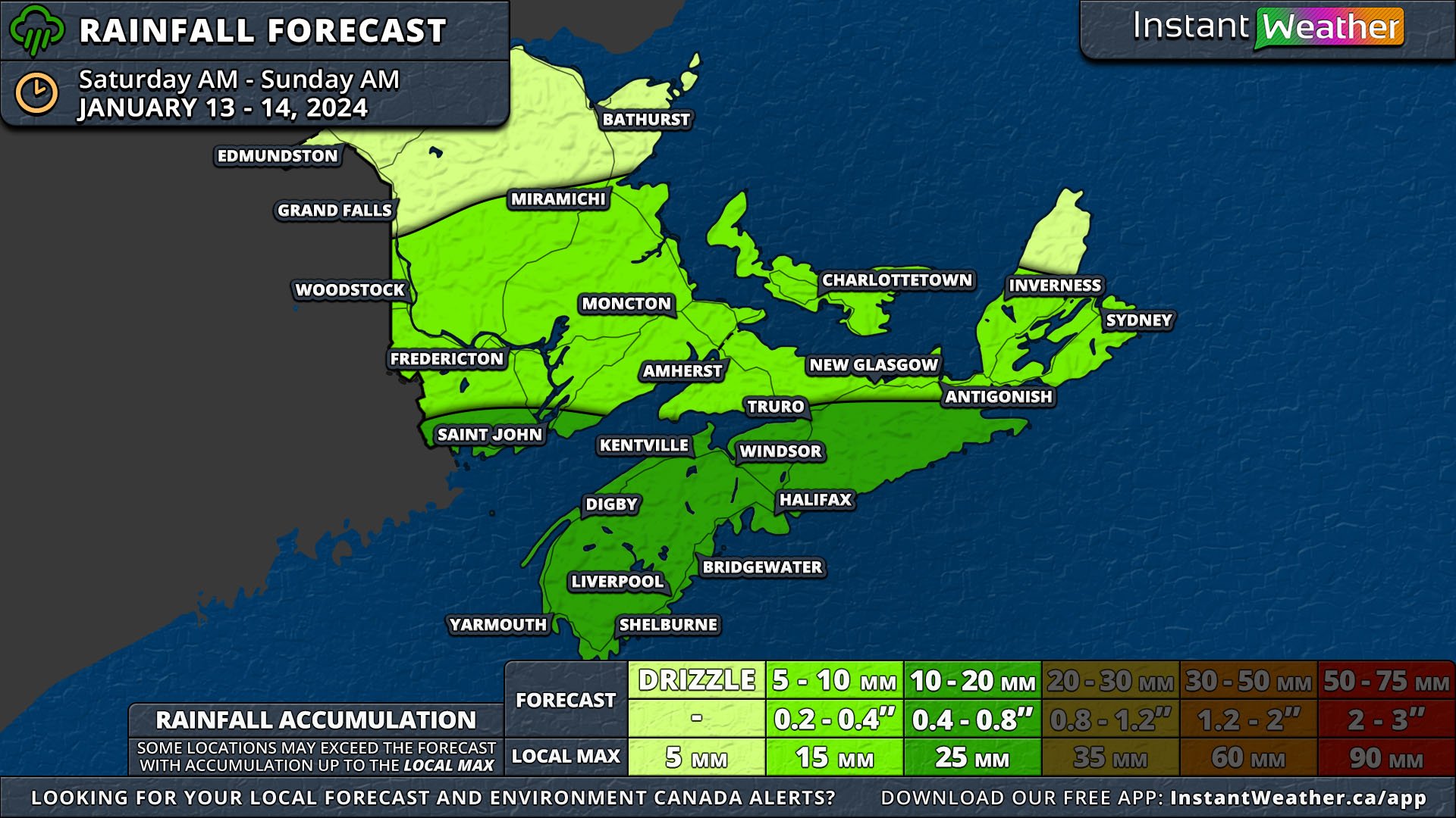
The precipitation is expected to hit Western Nova Scotia and New Brunswick in the late morning hours of Saturday and spread across the entirety of the Maritimes by the evening.
In Nova Scotia, it will begin as light snow or freezing rain before switching over and continuing as rain for the duration of the event. A majority of the province can expect 5-20mm of rain by Sunday afternoon.
Queens and Kings Counties in Prince Edward Island can also anticipate a bit of light snow to start in the early afternoon before it switches to rain and 5-10mm will fall.
These areas can expect to see a light dusting of less than 2cm of snow which will quickly be melted by the following rain and above freezing temperatures.
NOTE: YOU CAN CLICK ON THE MAP TO OPEN A ZOOMABLE IMAGE WHICH WILL BE EASIER TO READ.
Southeastern New Brunswick, including Moncton, and Prince’s County in PEI will start with some light snow (up to 5cm), followed by a couple of hours of freezing rain. Still, ice accretion will be limited to a couple of millimetres before the rain begins. Rainfall totals here are expected to be 5-10mm including freezing rain.
A bit further north and west, in a swath that includes Saint John and Fredericton, freezing rain remains a possibility, but more snow is expected before the changeover to rain. Upwards of 10cm should fall in this region and rainfall totals should cap out at 10mm, with the Saint John area approaching 15mm.
Moving northwards, much less rain, a maximum of 5mm, is expected and precipitation will fall mostly as sleet (ice pellets) and snow for most of the storm before a transition to rain towards the end of the event.
Across the northernmost part of New Brunswick, temperatures will climb overnight to hover around the freezing mark so it’s not expected that there will be a change from snow to rain, but it can’t be completely ruled out that there may be a few drops. This area is where snowfall totals will exceed 15cm.

Another major factor with the storm, as with the one on Wednesday, will be damaging wind gusts, however, the winds are expected to be much stronger in some areas. Along the Atlantic Coast in Nova Scotia and across PEI, gusts will be over 90km/h.
Southern New Brunswick and in the interior of Nova Scotia can expect wind gusts up to 90km/h, but there is the possibility of stronger gusts along the Fundy Coast.
The strength of the winds will diminish moving northwards through New Brunswick, apart from the Acadian Peninsula, which should limit hazardous driving conditions due to blowing snow and the likelihood of the blizzard conditions that have been associated with this storm in areas to the west.
The strongest wind gusts will be found along the coast of Digby and Yarmouth Counties where gusts will likely exceed 100km/h. The same also goes for the coast of Inverness County, however, there is the possibility that gusts could top out over 130km/h here.
Along with the issues caused by damaging winds such as downed trees and power lines, pounding surf and storm surge will be a threat with this storm as the timing will correlate with astronomical high tide Saturday afternoon and evening.
