Messy Commute Ahead: Prolonged Freezing Rain Risk in Parts of Southern Ontario Starting Wednesday Afternoon
/UPDATED FORECAST:
OLD FORECAST:
Ontario has seen an early onset of winter weather with multiple snowfalls, yet the first true ‘winter storm’ has been absent—until now. A complex wintery mix looms, set to deliver a blend of freezing rain, ice pellets, and heavy snow to parts of the province beginning Wednesday.
A system from the US Midwest will arrive in Ontario by Wednesday afternoon. As the initial bands of precipitation first reach Southwestern Ontario, the rain will meet a pocket of cold air at ground level, leading to the formation of freezing rain.
The higher terrain of Southwestern Ontario, just northwest of the Greater Toronto Area (GTA), could face extended periods of freezing rain, peaking during the evening rush hour.
Locations like Guelph, Kitchener, Hanover, and Orangeville might see freezing rain lasting throughout the late afternoon and early evening.
Areas around Lake Simcoe are also in the bullseye for a mix of freezing rain, ice pellets, and wet snow starting early in the evening.
Overnight, temperatures are predicted to climb, transitioning the freezing rain in Southwestern Ontario to plain rain, while Eastern and Central Ontario will likely see snow and ice pellets.
By Thursday morning, however, the southern portion of Central/Eastern Ontario—stretching from Muskoka through Bancroft to the Ottawa Valley—may experience some freezing rain.
Our forecast splits the difference, with up to 5-10mm of ice accumulation in the Dundalk Highlands and east of Lake Huron, with 2-5mm possible in the northern GTA, around Lake Simcoe, and towards Peterborough.
Light icing is likely across Central and Eastern Ontario with freezing drizzle during Thursday's early hours. Remember, ice accumulation will depend on the precise temperatures and how swiftly they rise past freezing. Given the short duration, the impact should be more limited.
Yet, even this amount of ice can cause treacherous roads and power outages, not to mention the potential for school bus cancellations, especially in Central and Eastern Ontario, where conditions will remain challenging into Thursday morning.
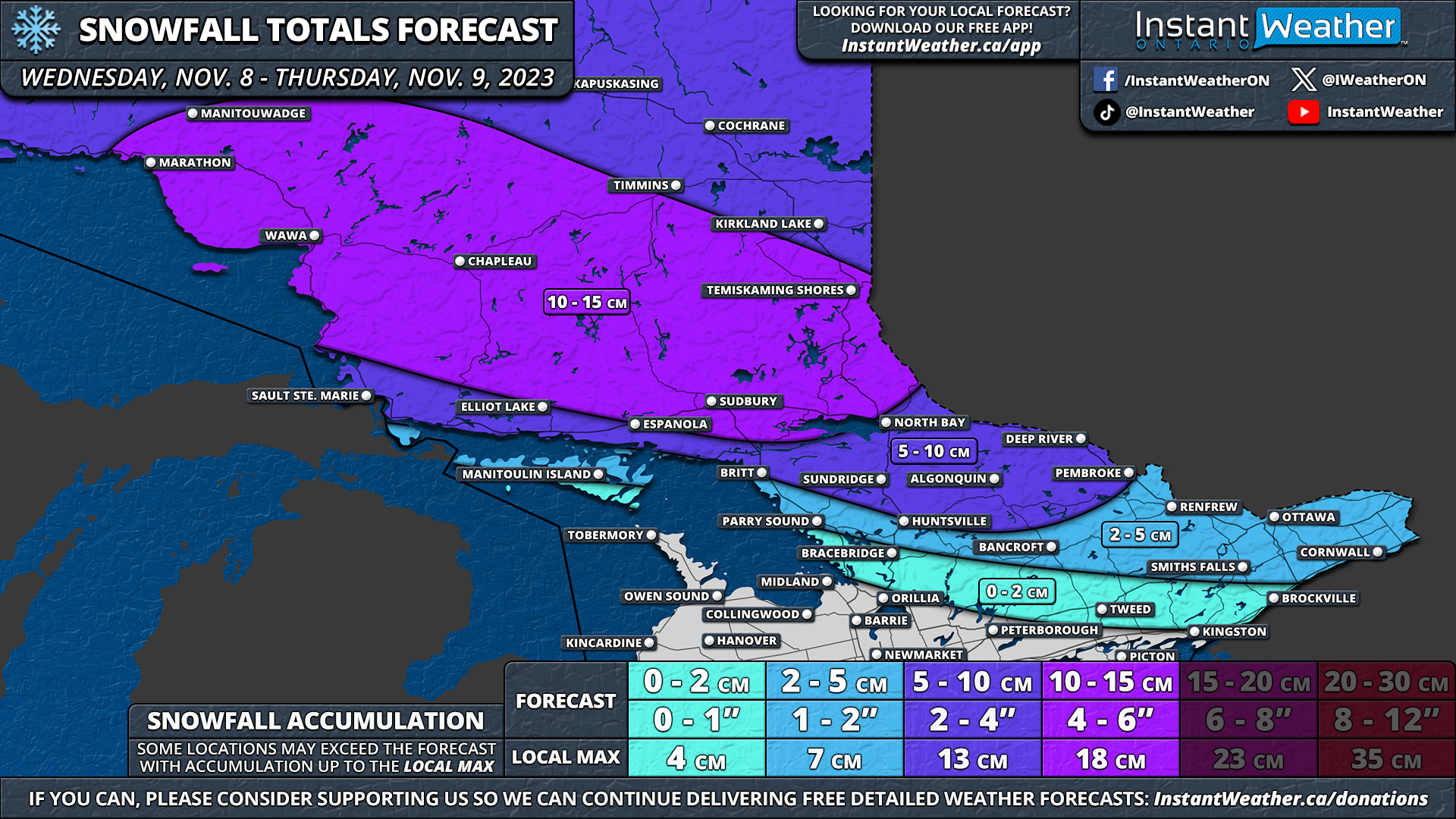
Northeastern Ontario is set to see primarily snowfall, with ice pellets likely near Sudbury and North Bay. Snowfall begins late Wednesday and continues into early Thursday, with the heaviest snow expected overnight at rates of 2-3cm per hour.
Initial data showed Northeastern Ontario could receive up to 30cm of snow, but recent updates suggest a more manageable 10-15cm for Sudbury, Chapleau, and Temiskaming Shores. Elsewhere in Northern Ontario, from Thunder Bay to the Manitoba border, 5-10cm is forecasted.
Moving south into Central and Eastern Ontario, less snow is anticipated. Algonquin Park and northern Central Ontario may still see a notable accumulation of 5-10cm with ice pellets, while less than 5cm is expected for the remainder of these regions.
Rain is on the menu for Windsor, Chatham, Sarnia, London, and the Golden Horseshoe, which will sidestep the winter conditions. Come Thursday, they can expect 10-20mm of rain, with potential for higher localized totals.


