Potential Snowstorm on the Horizon for Southern Ontario; Up to 20–30cm of Snow Possible on Thursday
/FORECAST UPDATE - FEB. 15 @ 10:55 AM
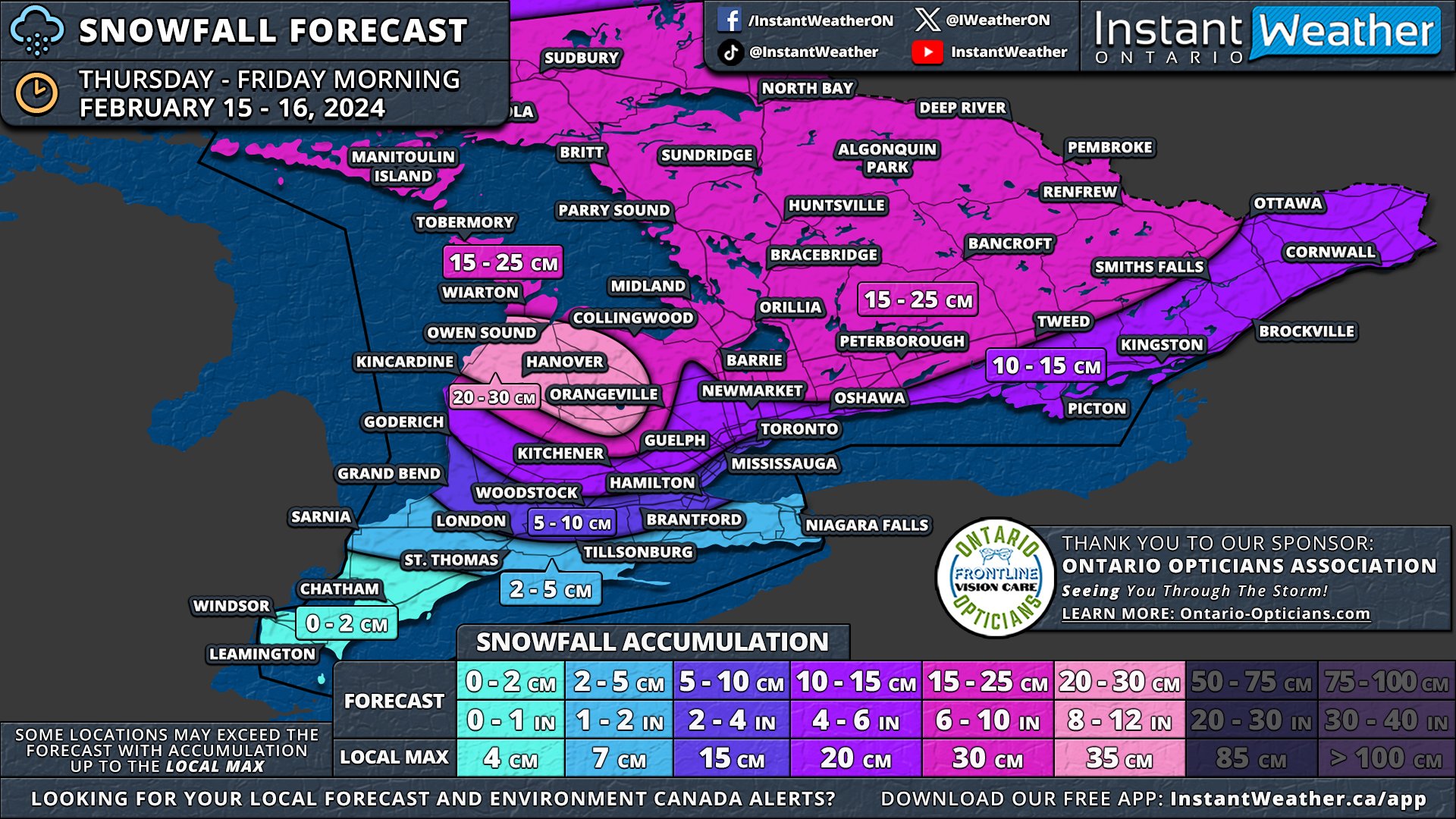
After reviewing the latest data, we've made several adjustments to our final forecast map for the snowfall set to begin later this morning and extend into the afternoon.
The worst conditions are expected during the afternoon hours with strong wind gusts leading to blowing snow and reduced visibility on the roads. Conditions will improve by the end of the day for most areas, but snow squalls will develop off Lake Huron and Georgian Bay later tonight.
The primary update is that we now anticipate the higher snowfall totals, exceeding 15cm, to be more localized to Central Ontario and the Grey-Bruce region. This is where lake effect snow is expected to enhance snowfall rates. Consequently, we've adjusted the forecast range from 15-25cm down to 15-20cm, as the higher end of the range no longer seems supported by current data. While some areas may still experience local amounts up to 25cm, such occurrences will be relatively isolated.
Areas including Port Elgin, Hanover, and Chatsworth are predicted to see around 20-30cm, combining system snow on Thursday with snow squall activity beginning late Thursday night into Friday. This zone has been narrowed as models provide greater clarity on the specific areas likely to be impacted by snow squall activity.
For locations such as Kitchener, Guelph, Barrie, Peterborough, Smiths Falls, and Ottawa, snowfall totals are projected to be around 10-15cm. In the stretch from the Greater Toronto Area through to Kingston and into Extreme Eastern Ontario, we are forecasting 5 to 10cm of snow. Totals are expected to lean towards the 10cm mark further from the Lake Ontario shoreline, with those in closer proximity likely receiving closer to 5cm.
In the south, anticipated snow amounts for London and Hamilton have been revised downwards from 5-10cm to 2-5cm. Along the Lake Erie shoreline and into Deep Southwestern Ontario, minimal accumulation is expected due to a mix with rain.
earlier forecast
The snow drought that has held Southern Ontario in its grip for most of February is about to come to an end this Thursday with the arrival of an intense snowmaker. This system is on track to deliver widespread snowfall, with totals ranging from 10 to 25cm, and in some areas, as much as 30cm, thanks to lake effect snow east of Lake Huron.
Accompanying the heavy snow, strong wind gusts of 40-60 km/h are anticipated throughout Thursday. These conditions are likely to cause blowing snow and poor driving visibility, significantly impacting the evening commute across the Golden Horseshoe as well as Central and Eastern Ontario.
The lake effect snow is expected to persist into the weekend, affecting the usual snowbelt areas around Lake Huron and Georgian Bay. It's possible that localized snowfall amounts (including Thursday’s storm) could reach up to 50cm by week's end, particularly in Grey and Bruce counties where lake effect snow is forecasted to be most intense.
The system will approach from the west during late Thursday morning, initially impacting areas around Lake Huron before spreading eastward through the afternoon. Deep Southwestern Ontario, including Windsor, Chatham, and the Lake Erie shoreline, might start the day with mixed precipitation, including freezing rain, before transitioning to rain as temperatures rise.
By the afternoon, heavy snow will extend across Central Ontario and into the Golden Horseshoe. There remains some uncertainty regarding the extent of mixed precipitation to the north. Consequently, areas closer to the shoreline, such as Hamilton, Burlington, Brampton, and Toronto, may see some mixed precipitation which would reduce the snowfall totals here.
Central and Eastern Ontario will continue to experience snowfall into Thursday evening. The most challenging conditions are expected during the late afternoon and early evening when both wind and snowfall rates will be at the strongest.
The system is anticipated to gradually exit the province shortly after midnight. However, lake effect snow may develop off Lake Huron and Georgian Bay, with a particularly strong squall likely between Owen Sound and Kincardine overnight. Although expected to weaken by Friday morning, lake-effect snow may still linger throughout the day, especially in Huron, Wellington, Grey, and Bruce counties.
A zone with 20-30cm of snow has been added to the map to cover much of Grey and Bruce counties, including Port Elgin, Hanover, Chatsworth, and Owen Sound, to account for additional lake effect snow following the main system. Localized totals could surpass 30cm, depending on the intensity of the snow squall.
Given the latest data, we have increased confidence to adjust some areas from the 10-20cm zone to the 15-25cm zone, as this system appears to carry more moisture than initially expected. This adjustment affects much of Central Ontario and parts of Eastern Ontario.
Areas like Goderich, Kitchener, the northern Greater Toronto Area, Kingston, and the Ottawa Valley are expected to receive 10 to 15cm of snow as indicated by our earlier forecast. The exact totals here are more uncertain, and isolated pockets may exceed 15cm, depending on moisture distribution.
Near the Lake Ontario shoreline, lower snowfall totals are expected due to potential mixing and temperatures near the freezing mark. Cities such as Toronto, Mississauga, Oakville, Burlington, Hamilton, Woodstock, and London are projected to see 5-10cm of snow, though some locations, especially along the lakeshore, might not reach the 5cm mark.
The Niagara region and Deep Southwestern Ontario, including Sarnia, Chatham, and Windsor, are forecasted to see less than 5cm of snow. While significant snow accumulation isn't expected in these areas, freezing rain could pose a concern during late Thursday morning and early afternoon.
This system will also impact southern parts of Northeastern Ontario, with Elliot Lake, Sudbury, and North Bay set to receive 15 to 25cm of snow. The rest of Northeastern Ontario, including Sault Ste. Marie, Chapleau, Timmins, and Cochrane, can anticipate 5 to 15cm. Northwestern Ontario, including Thunder Bay, is expected to see less than 5cm of snow.


