Widespread Strong Severe Threat on Thursday for Southern & Northeastern Ontario

NOTE: YOU CAN CLICK ON THE MAP TO OPEN A ZOOMABLE IMAGE

The arrival of Ontario’s first prolonged heatwave of the season will start with a bang as a potent severe threat is expected on Thursday. Temperatures are predicted to soar into the upper 20s or even low 30s, providing a preview of what next week will feel like.

This heat, combined with an approaching cold front, is expected to spark off some intense storms during the afternoon and evening hours across Southern and Northeastern Ontario. There is a widespread 'strong' risk for severe weather, covering much of Central, Southwestern, and Northeastern Ontario, where damaging wind gusts, large hail, and a few tornadoes are possible.


GOOGLE AD (NOT ENDORSED BY INSTANT WEATHER)

In our preliminary forecast, we included a 'significant' risk zone on our map. While this event still looks quite dangerous, we have decided to downgrade to a 'strong' risk for our highest level in this forecast. To be clear, severe storms still seem almost certain in a large swath of Southern Ontario into Northeastern Ontario during the afternoon and early evening hours.

This isn’t to downplay what could still be a dangerous event, but we are careful about only using the higher severe levels for the strongest severe risks. The data no longer supports the criteria for our significant risk category. We feel confident that the 'strong' risk will be sufficient to cover these storms today.

We are already seeing storm development across Northeastern Ontario with severe thunderstorm warnings issued by Environment Canada as of 12 PM. Based on the latest models, further storm development is expected in a line stretching from Elliot Lake, across Manitoulin Island, and over Lake Huron between 2-4 PM.

This line will slowly track east, coming onshore between the Bruce Peninsula and Goderich around 4-6 PM. There is some uncertainty in the exact timing, so this may be off by a few hours if it arrives earlier or later than expected.

Additionally, we may see some isolated storm development ahead of this line across Central Ontario, especially around Georgian Bay and Lake Simcoe, anytime between 4 to 8 PM. These isolated storms will have a strong environment to work with and could present severe hazards including hail up to the size of golf balls, damaging wind gusts, and tornadoes.


GOOGLE AD (NOT ENDORSED BY INSTANT WEATHER)

By the evening, the focus will shift towards more of a damaging wind threat, although an isolated tornado could still be possible. An organized line of strong to severe storms is expected to stretch from Algonquin Park through Lake Simcoe and to the southwest into London and Kitchener. This line will track east towards the Golden Horseshoe, Peterborough, and eventually the Ottawa Valley.

Again, the timing is still uncertain as some models indicate the line reaching the Greater Toronto Area and Ottawa Valley by early evening while others suggest it won’t arrive until closer to midnight. The later the storm arrives, the weaker it will likely be as the prime environment fueling these storms will quickly fade away after sunset.

Heavy rain and non-severe thunderstorms will continue throughout Eastern Ontario during the overnight hours and into Friday morning. However, the severe threat for all of Southern Ontario will come to an end by midnight.


GOOGLE AD (NOT ENDORSED BY INSTANT WEATHER)

thunderstorm risk checklist

NOTE: YOU CAN CLICK ON THE MAP TO OPEN A ZOOMABLE IMAGE

To help you better understand how we come up with our forecast, here’s a look at the checklist we used to determine the threat for today.

We expect that some of the storms could produce widespread wind damage along with hail up to the size of golf balls. This correlates to a 'strong' (level 3) risk according to our criteria.

Our previous forecast, where we had a 'significant' (level 4) risk, was due to the potential for destructive wind gusts. However, based on the latest data, we no longer have enough confidence that the wind gust threat will reach the threshold to be considered widespread and destructive.

The tornado threat remains the same as our preliminary forecast, which would be considered a 'slight' (level 2) risk. We don’t expect several tornadoes today as this is primarily a wind and hail-driven severe event, but one or two tornadoes somewhere in our strong and slight risk zones are possible.

The flooding threat with these storms is marginal as the line will be moving quite fast as it sweeps across the province. Most areas will see between 20 to 40 mm of rain with locally up to 50-75 mm.


GOOGLE AD (NOT ENDORSED BY INSTANT WEATHER)

NOTE: YOU CAN CLICK ON THE MAP TO OPEN A ZOOMABLE IMAGE

For Northeastern Ontario, there is a similar risk for strong severe storms in locations including Timmins, Kirkland Lake, and Temiskaming Shores. The tornado threat may actually be slightly higher in this area as we expect more isolated storm activity compared to the south.

Storms have already started to develop in parts of Northeastern Ontario and are expected to continue throughout the afternoon as they slowly track towards the Quebec border. Additional storms may develop during the evening hours, but the storm threat should diminish by 9 to 10 PM.

Potentially Significant Severe Threat in Southern Ontario on Thursday; Tornadoes, Destructive Wind Gusts and Large Hail Possible

THIS FORECAST HAS BEEN UPDATED


NOTE: YOU CAN CLICK ON THE MAP TO OPEN A ZOOMABLE IMAGE

Confidence is growing for what could be Southern Ontario’s strongest severe thunderstorm risk of the year so far. The latest model data points to a potent environment developing throughout the afternoon and evening on Thursday.

As a result, we have issued a significant (level 4/5) severe risk due to the widespread severe threat. Locations affected include Orangeville, Collingwood, Newmarket, Barrie, Orillia, Midland, Peterborough, Bracebridge, Huntsville, Parry Sound, Algonquin Park, and North Bay.


GOOGLE AD (NOT ENDORSED BY INSTANT WEATHER)

These threats could include destructive wind gusts over 100-110 km/h (potentially up to 125 km/h) and large hail up to the size of toonies or golf balls. Tornadoes are also likely, especially along the Barrie, Orillia to Muskoka corridor, where models show a strong agreement on this area featuring the most intense environment.

The surrounding region, including the Lake Huron shoreline extending through Kitchener and into the Greater Toronto Area, has a strong risk of severe thunderstorms. The environment remains quite favourable for severe weather here, though there is more uncertainty about storm development. If storms form, they will be able to take advantage of the strong environment.

Those in Eastern Ontario along the St. Lawrence and Deep Southwestern Ontario have a marginal severe risk. This is because the environment is weaker and likely won’t support any major severe weather threats.

More detailed timing information will be coming in an updated forecast on Wednesday or early Thursday.


NOTE: This is a preliminary forecast and is subject to change. Please check back for the latest updates so you can properly prepare as we get closer to the event.


GOOGLE AD (NOT ENDORSED BY INSTANT WEATHER)

Northern Ontario could also see some stormy weather on Thursday. We currently have a slight risk for a portion of Northeastern Ontario along the Quebec border and stretching southward towards Georgian Bay. North Bay likely has the strongest risk of anywhere else in Northern Ontario.

The risk will lessen further to the north and west. However, Northwestern Ontario could be dealing with quite an active day on Wednesday. The main threat will be large hail and possibly some tornadoes. More details on that will follow soon, including a full forecast.


GOOGLE AD (NOT ENDORSED BY INSTANT WEATHER)

Widespread Severe Thunderstorm Risk Across Southern & Northeastern Ontario on Wednesday

NOTE: YOU CAN CLICK ON THE MAP TO OPEN A ZOOMABLE IMAGE

As we welcome the first days of June across Southern Ontario, the warmer temperatures are a noticeable change from the end of May. Just last week, we were dealing with frost advisories in parts of the province. Now, temperatures are well into the 20s or even low 30s.

However, the bubbling heat will come at a cost with the return of thunderstorms, fueled by the hot temperatures. A line of storms, along with isolated cells ahead of it, is expected to extend from Northeastern Ontario southward into Southwestern Ontario sometime Wednesday afternoon or early evening.


GOOGLE AD (NOT ENDORSED BY INSTANT WEATHER)

Based on the predicted environment, these storms will have the potential to bring a ‘slight’ severe risk with damaging wind gusts up to 100 km/h as the primary threat. Hail up to the size of quarters and an isolated tornado threat can’t be ruled out.

There is some disagreement on exactly where this line will develop, which is associated with a cold front cutting across the region and bringing an end to the warmer temperatures. When this front arrives will be key to the overall storm threat. While storms could develop ahead of the line, the bulk of the severe threat will be concentrated with the squall line setup stretching from Lake Superior down into Michigan.

The latest data suggests that this line could form earlier in the day and start to cross over Lake Huron by the late afternoon or around the dinner hour. If it does end up arriving this early, the storms will be moving into a strong environment, allowing the squall line to potentially bring widespread damaging wind gusts as it tracks into Southwestern Ontario.


GOOGLE AD (NOT ENDORSED BY INSTANT WEATHER)

On the other hand, a later arrival in the evening would likely lead to the line of storms being weaker than expected and may only reach marginally severe levels. We do expect some gradual weakening in the line throughout the evening as it tracks into Central and Eastern Ontario by the mid to late evening hours. Non-severe thunderstorms could continue overnight and into early Thursday morning for Eastern Ontario.

As mentioned, we could see a few isolated cells pop up in Southwestern Ontario and maybe even around Lake Simcoe and Georgian Bay during the late afternoon ahead of the main line. If these storms can establish themselves, they could bring all severe hazards, including damaging wind gusts and up to toonie-sized hail. A tornado can’t be ruled out as these storms will have all the environment to themselves.

It should be noted that confidence in the isolated storms ahead of the line is questionable in Southern Ontario but could be more of a problem as we look at Northern Ontario.


For Northeastern Ontario, the confidence in isolated storms is much higher as we could see several cells develop along the Sudbury to Geraldton corridor during the afternoon and early evening. Similarly to Southern Ontario, these storms could bring damaging wind gusts and large hail, and the tornado risk is a little more elevated here due to a stronger environment.

This is also in addition to the squall line that will cross into the region from Lake Superior sometime around the dinner hour. At this point, the main threat will be damaging wind gusts up to 100 km/h, but we could still see some marginally severe hail and an isolated tornado. The squall line will gradually weaken as it tracks towards Quebec by the midnight hour.


GOOGLE AD (NOT ENDORSED BY INSTANT WEATHER)

There is a slight risk for severe storms stretching from Manitoulin Island through Elliot Lake and into Geraldton and Armstrong. This also includes the Lake Superior shoreline between Sault Ste. Marie and Marathon. The rest of Northeastern Ontario has a marginal severe risk.

For Northwestern Ontario, there could be a few pop-up storms during the afternoon and evening with a marginal risk around Thunder Bay. This risk will quickly diminish after sunset, which is providing the fuel to the pop-up cells.

Late Friday Wind Storm to Give Way to a Snowy Start to the Weekend in Parts of Ontario With Up to 10cm of Snow

NOTE: YOU CAN CLICK ON THE MAP TO OPEN A ZOOMABLE IMAGE

The weather across Southern Ontario has been largely characterized by spring-like conditions, with temperatures soaring into the 20s and the season’s first widespread severe weather event occurring on Tuesday. This pattern continued into Thursday and Friday with heavy rainfall, but a change is on the horizon for the weekend.

Persistent rain across Southern and Northern Ontario on Friday is expected to transition to snow overnight into Saturday morning. For most areas, the snow should melt upon contact, with limited accumulation. However, higher elevations around Georgian Bay and into Northeastern Ontario could see snow accumulations of 5-10cm by Saturday afternoon.


GOOGLE AD (NOT ENDORSED BY INSTANT WEATHER)

NOTE: YOU CAN CLICK ON THE MAP TO OPEN A ZOOMABLE IMAGE

Before the snow arrives, strong wind gusts are anticipated to develop by Friday afternoon, continuing overnight into Saturday morning.

The strongest gusts, possibly exceeding 90 km/h, are expected along the Lake Huron shoreline and the southeastern shoreline of Georgian Bay.

The hardest hit regions include Kincardine, Goderich, Grand Bend, and Collingwood which could experience wind strong enough to potentially cause damage, including power outages.

In Southwestern Ontario and the Golden Horseshoe, wind gusts are predicted to range from 70 to 90 km/h. Eastern Ontario will see less impact, with wind gusts expected to stay below 70 km/h. The wind is expected to subside by sunrise on Saturday.


GOOGLE AD (NOT ENDORSED BY INSTANT WEATHER)

Northeastern Ontario will also experience strong gusts from Friday afternoon into the evening, with the areas directly north of Georgian Bay like Elliot Lake, Manitoulin Island, and Sudbury seeing the strongest gusts, approaching 80-90 km/h.

Widespread gusts of 70-80 km/h are expected in the rest of Northeastern Ontario, with lower gusts further north and west.


GOOGLE AD (NOT ENDORSED BY INSTANT WEATHER)

As colder air sweeps into the region overnight, temperatures across Central Ontario and the Dundalk Highlands are likely to hover around the freezing mark into Saturday morning. This will cause the existing rain to transition into wet snow or flurries starting Friday evening.

With temperatures near freezing and recent rainfall, it’s questionable if the snow will stick or accumulate. The best chance for accumulation is in higher elevations such as Shelburne, Orangeville, and the Blue Mountains, where up to 5-10cm of snow could accumulate by Saturday morning.

Surrounding areas extending into Central Ontario, including Barrie, Orillia, Muskoka, and the Kawartha Lakes, might see minor accumulations of 2 to 5cm. This will vary based on local conditions, which could impact the snow's ability to accumulate. Regardless, the area is likely to experience sloppy conditions and icy roads as near-freezing temperatures cause existing rain on roads to freeze and create black ice.

The rest of Southern Ontario will see less than 2cm of snow or no snow at all, as will be the case in Deep Southwestern Ontario, the Golden Horseshoe, and Eastern Ontario.


GOOGLE AD (NOT ENDORSED BY INSTANT WEATHER)

NOTE: YOU CAN CLICK ON THE MAP TO OPEN A ZOOMABLE IMAGE

Colder temperatures in parts of Northeastern Ontario will allow for better snow accumulation, with areas like Timmins and Cochrane expecting up to 10cm of snow. The rest of Northeastern Ontario, except for regions north of the Georgian Bay shoreline, could see between 5-10cm of snow by Saturday afternoon. Less than 5cm is expected near the Georgian Bay shoreline due to warmer temperatures.

Snowfall is expected to cease across all parts of Ontario by early Saturday afternoon. The weekend will remain chilly for most areas, with temperatures stuck in the single digits on Saturday and Sunday, except in Deep Southwestern Ontario.

Windsor and Chatham may experience a pocket of warmer air, especially on Sunday, with temperatures potentially reaching the 20s and a risk of thunderstorms. The rest of Southern Ontario will see daytime highs in the mid to upper single digits on Sunday.

Severe Thunderstorm & Isolated Tornado Threat on Tuesday for Southern Ontario

NOTE: YOU CAN CLICK ON THE MAP TO OPEN A ZOOMABLE IMAGE

After experiencing a chilly start to April, Southern Ontario is finally feeling the warmth, bringing a more spring-like atmosphere to the region. This warmth will be especially noticeable on Tuesday as temperatures are expected to climb into the upper teens or even low 20s in some areas.

This warming, combined with an approaching cold front later on Tuesday, will set the stage for the development of thunderstorms.

A potent environment conducive to thunderstorm development is expected to materialize across Southwestern and Central Ontario during the afternoon, fueled by ample daylight heating from the warmer temperatures.


GOOGLE AD (NOT ENDORSED BY INSTANT WEATHER)

As the cold front sweeps through the province starting in the late afternoon, a line of storms is anticipated to form, extending from North Bay towards Georgian Bay and into regions east of Lake Huron. According to the latest model data, these storms have the potential to become severe, with all types of severe thunderstorm threats being possible.

A slight severe thunderstorm risk extends from Kitchener through Orangeville and Simcoe County into Central Ontario, with a particular emphasis on the corridor from Orangeville to Bracebridge, where models indicate the most conducive environment for severe storm development. The primary window for these storms is between 3 to 8 PM, varying with the arrival time of the cold front.

These storms could bring large hail, up to the size of quarters or ping pong balls, wind gusts of up to 100 km/h, and the possibility of an isolated tornado cannot be ruled out.


GOOGLE AD (NOT ENDORSED BY INSTANT WEATHER)

Areas within the isolated severe risk zone might experience a few storms, but the confidence is lower compared to those within the slight severe zone. As the evening progresses, the risk will evolve into a wind threat as the storms merge into a main squall line, advancing towards the Golden Horseshoe and Eastern Ontario.

In Eastern Ontario, non-severe thunderstorms are anticipated around midnight as the weakening line of storms moves through. Although the severe weather risk is expected to be low by the time the storms arrive, small hail and strong wind gusts are still possibilities.


GOOGLE AD (NOT ENDORSED BY INSTANT WEATHER)

NOTE: YOU CAN CLICK ON THE MAP TO OPEN A ZOOMABLE IMAGE

For Northeastern Ontario, an isolated severe storm threat is forecasted near the North Bay area as storms develop off Georgian Bay. The severity of the storms is expected to lessen further north, with non-severe thunderstorms predicted for the majority of Northeastern Ontario.


GOOGLE AD (NOT ENDORSED BY INSTANT WEATHER)

UPDATE: Clouds May Move Out Just in Time for the Solar Eclipse on Monday in Parts of Southern Ontario at the Expense of Eastern Ontario

NOTE: YOU CAN CLICK ON THE MAP TO OPEN A ZOOMABLE IMAGE

We are on the eve of the total solar eclipse set to dim the skies across Southern Ontario on Monday. With the event about 24 hours away, our confidence in the viewing conditions within our region is sharpening. Clear skies are crucial for those looking to fully experience the eclipse, a phenomenon eagerly awaited by many for years.

The experience of a total solar eclipse differs significantly under clear versus cloudy skies. Clear conditions allow observers to witness the dramatic dimming of daylight, a noticeable drop in temperature, and the visibility of stars and planets.

The eclipse's most breathtaking moment, the emergence of the sun's corona, is visible only during totality, revealing delicate, radiant strands extending from the moon's silhouette, an image no camera or telescope capturing partial phases can replicate.

Under cloudy conditions, while some cooling and dimming effects may still be perceptible, the visual spectacle is significantly diminished. Clouds mask the corona, stars, and planets, greatly reducing the visual impact of the eclipse.


GOOGLE AD (NOT ENDORSED BY INSTANT WEATHER)

SAFETY WARNING

To safely enjoy the eclipse, it's imperative to use ISO 12312-2 certified solar glasses. Directly observing the sun, even during an eclipse, can cause serious damage to your eyes. You can only view the eclipse without the glasses during the few minutes of totality. Solar glasses are designed to block harmful solar radiation and protect your eyes while allowing you to safely witness the event.

Never use makeshift viewing solutions like sunglasses or homemade filters, as they do not offer adequate protection against the sun's rays. Also, remember that the same rules apply to taking pictures with your phone. The sun can damage your camera’s sensors if you don’t have the proper solar filter (such as the same solar glasses for your eyes).


your guide to the eclipse:


Our initial forecast pointed to the possibility of clouds moving into Southern and Northern Ontario from late Sunday into Monday morning. This outlook holds, according to the latest models, albeit with slight adjustments in the anticipated locations of the densest cloud cover.

A key change concerns Eastern Ontario, where the front edge of the cloud cover is now forecasted to arrive several hours earlier than previously thought. Consequently, areas such as Kingston, Belleville, and Brockville might experience increasing cloudiness before the eclipse begins, potentially obscuring views of the later stages, including totality around 3 PM.

In the Ottawa Valley, cloud coverage remains a possibility, though a very narrow strip of Extreme Eastern Ontario, around Cornwall, is expected to maintain clear skies for the majority of the eclipse. While high-level clouds may still be present, they shouldn't hinder eclipse viewing, as the sun's light should penetrate through.

This shift in cloud movement toward the east spells good news for those in Deep Southwestern Ontario. We now have increased confidence that locations southwest of London, including Sarnia, Chatham, Leamington, and Windsor, will enjoy mostly clear skies at the eclipse's peak.

Even parts of Southwestern Ontario, extending from the southwestern shore of Lake Huron to the Kitchener/Waterloo region, might see clouds dissipate in time for the eclipse.


GOOGLE AD (NOT ENDORSED BY INSTANT WEATHER)

The outlook for the Golden Horseshoe, including the Greater Toronto Area and Niagara region, is more uncertain. Clouds are expected to obscure the early stages of the eclipse in the afternoon, but recent high-resolution models suggest possible breaks in the cloud cover around 3 PM, coinciding with the eclipse's maximum.

There's hope that this trend towards earlier cloud clearance continues, potentially offering clear views over the Niagara region right in time for totality. While not guaranteed, the possibility remains, so keep your fingers crossed.

In contrast, Central Ontario and the Georgian Bay shoreline are expected to be under thick clouds during the eclipse, likely obstructing views. Those in these areas hoping to witness the eclipse may need to consider travelling to clearer locations.


NOTE: YOU CAN CLICK ON THE MAP TO OPEN A ZOOMABLE IMAGE

In Northern Ontario, prospects for viewing the partial solar eclipse are less favourable, with extensive cloud cover predicted from Georgian Bay to the Lake Superior shoreline.

Locations such as Elliot Lake, Sault Ste. Marie, Wawa, and Marathon are unlikely to have a clear view of the eclipse. Cloud coverage in Northeastern Ontario is expected to be mostly dense, though it may become more scattered further north.


GOOGLE AD (NOT ENDORSED BY INSTANT WEATHER)

NOTE: YOU CAN CLICK ON THE MAP TO OPEN A ZOOMABLE IMAGE

As we look at Northwestern Ontario, the viewing conditions are quite poor, especially around the Lake Superior shoreline including Thunder Bay, Kenora and the Armstrong region. Thick clouds will likely make the eclipse hard to view.

Clouds Threaten to Spoil the Solar Eclipse on Monday in Parts of Ontario but Not for Everyone

CLICK HERE FOR THE UPDATED FORECAST

NOTE: YOU CAN CLICK ON THE MAP TO OPEN A ZOOMABLE IMAGE

The countdown is on for the total solar eclipse set to darken the skies across Southern Ontario on Monday. As the big day approaches, we're gaining a clearer understanding of the expected weather conditions during the eclipse. Clear skies are essential for experiencing the full marvel of the eclipse, an event eagerly anticipated by many for years.

Experiencing a total solar eclipse varies dramatically under clear versus cloudy skies. Clear skies allow you to witness the significant dimming of daylight, a noticeable drop in temperature, and the emergence of stars and planets.

The eclipse's crowning moment, the visibility of the sun's corona, occurs exclusively during totality. This presents the corona's delicate, luminous strands extending from the moon's silhouette in a spectacle unmatched by any camera or telescope viewing partial phases.

However, under cloudy skies, though you may still observe a cooling and dimming effect, the visual wonder is significantly obscured. Clouds conceal the corona, stars, and planets, greatly diminishing the eclipse's visual splendour.


GOOGLE AD (NOT ENDORSED BY INSTANT WEATHER)

SAFETY WARNING

To safely enjoy the eclipse, it's imperative to use ISO 12312-2 certified solar glasses. Directly observing the sun, even during an eclipse, can cause serious damage to your eyes. You can only view the eclipse without the glasses during the few minutes of totality. Solar glasses are designed to block harmful solar radiation and protect your eyes while allowing you to safely witness the event.

Never use makeshift viewing solutions like sunglasses or homemade filters, as they do not offer adequate protection against the sun's rays. Also, remember that the same rules apply to taking pictures with your phone. The sun can damage your camera’s sensors if you don’t have the proper solar filter (such as the same solar glasses for your eyes).


your guide to the eclipse:


The weather forecast offers a mix of optimism and caution. Some areas in the path of totality in Southern Ontario might face cloudy conditions, potentially obscuring the eclipse. Yet, certain regions in Eastern Ontario and along the Lake Erie shoreline are expected to enjoy clear skies, offering an unobstructed view of the eclipse.

The latest models predict clouds moving in from the southwest late Sunday, leading to overcast conditions in much of Southwestern, Central Ontario, and the Golden Horseshoe by Monday morning. These clouds are expected to spread eastward throughout the morning and early afternoon, with discrepancies among models regarding the extent and timing of the cloud cover.


GOOGLE AD (NOT ENDORSED BY INSTANT WEATHER)

By early afternoon, clearing is anticipated in Deep Southwestern Ontario, just in time for the eclipse's start around 2 PM. In contrast, from Niagara Falls through the GTA to Central Ontario, clouds are likely to persist, though intermittent breaks might still offer glimpses of the eclipse.

Eastern Ontario faces a race against time, with increasing cloudiness expected. The northeastern tip, including Cornwall, may remain clear until later in the afternoon, offering potentially favourable conditions for eclipse viewing. Kingston and Belleville should be mostly clear to start, but again, clouds will increase in coverage during the eclipse so hopefully it can hold off until after totality occurs.

NOTE: YOU CAN CLICK ON THE MAP TO OPEN A ZOOMABLE IMAGE

In Northern Ontario, prospects for viewing the partial solar eclipse are less favourable, with extensive cloud cover predicted from Georgian Bay to the Lake Superior shoreline.

Locations such as Elliot Lake, Sault Ste. Marie, Wawa, and Marathon are unlikely to have a clear view of the eclipse. Cloud coverage in Northeastern Ontario is expected to be mostly dense, though it may become more scattered further north and east.


GOOGLE AD (NOT ENDORSED BY INSTANT WEATHER)

NOTE: YOU CAN CLICK ON THE MAP TO OPEN A ZOOMABLE IMAGE

As we look at Northwestern Ontario, the viewing conditions are quite poor especially around the Lake Superior shoreline including Thunder Bay and into the Armstrong region. Thick clouds will likely make the eclipse hard to view. There is some chance that those closer to the Manitoba border may see some breaks in the clouds, but it’s unlikely.

Winter Storm Threat Looms for Ontario With Up to 30cm of Snow and 60mm of Rain by Thursday

NOTE: YOU CAN CLICK ON THE MAP TO OPEN A ZOOMABLE IMAGE

The beginning of April in Ontario is setting the stage for a dramatic shift in weather, as a moisture-laden system promises a variety of conditions across the region. This shift includes the potential for flooding rains, with predictions of 40 to 60mm of rain in parts of the Golden Horseshoe.

In addition, areas of Central, Eastern, and Northern Ontario are on track for significant snowfall, with totals ranging from 20 to 35cm in the most affected areas!

As outlined in our previous forecasts, this bout of active weather kicked off with strong wind gusts on Tuesday afternoon, expected to persist into the night.


GOOGLE AD (NOT ENDORSED BY INSTANT WEATHER)

With the wind gradually subsiding, our attention now shifts to the substantial moisture being pumped into our region from the Gulf of Mexico. Initially, this precipitation will begin as heavy rain, with intense downpours expected overnight and into Wednesday morning across the Greater Toronto Area, extending into Central and Eastern Ontario.

However, by late Wednesday, colder air from the northwest will sweep in, prompting a gradual transition from rain to wet snow by the late afternoon in parts of Central and Eastern Ontario. Northeastern Ontario, already under colder air by the morning, may experience snow for the duration of this event.

The challenge in forecasting this system lies in the temperatures hovering near the freezing point, significantly impacting snow accumulation. Additionally, model predictions vary on the timing of the transition from rain to snow, some suggesting it won't occur until late Wednesday evening, while others indicate it will occur around 2 to 5 PM.

By Wednesday night, most regions, including the Golden Horseshoe, are expected to have transitioned to wet snow, with light to moderate snowfall persisting into Thursday morning and afternoon, concluding by Thursday evening.


GOOGLE AD (NOT ENDORSED BY INSTANT WEATHER)

NOTE: YOU CAN CLICK ON THE MAP TO OPEN A ZOOMABLE IMAGE

Elevation will be a crucial determinant of snowfall totals, with the highest accumulations forecasted southwest of Ottawa in Eastern Ontario's elevated areas. This includes Bancroft, Barry’s Bay, Algonquin Park, and Renfrew, with expected snowfall totals ranging from 20 to 35cm by Thursday's end.

For the Ottawa Valley, including Ottawa, Cornwall, Brockville, and Pembroke, snowfall totals are more uncertain, ranging from 10 to 25cm. This variability will depend on local dynamics and the ability of snow to stick to the ground. There is the potential that some areas will exceed our forecast if the snow can stick more efficiently to the ground.

Further south and westward, snowfall totals are expected to range from 5 to 15cm, including Kingston, Peterborough, Huntsville, and Sundridge. Local areas north of the Greater Toronto Area, particularly along the higher elevations of the Oak Ridges Moraine and Dundalk Highlands, may also see up to 10 to 15cm. This forecast is heavily dependent on temperatures, which may not drop below freezing until Thursday morning, affecting accumulation.

Areas east of Georgian Bay and away from Lake Ontario's shoreline are likely to exceed 5cm but should remain under 10cm. Regions directly along the Lake Ontario shoreline and parts of Southwestern Ontario will experience less than 5cm of snow, as rain will dominate these areas.


GOOGLE AD (NOT ENDORSED BY INSTANT WEATHER)

In addition to significant snowfall in Central and Eastern Ontario, significant rainfall is anticipated along Lake Ontario's shoreline, including Prince Edward County, Oshawa, Toronto, Mississauga, Burlington, Hamilton, and Grimsby, with potential totals ranging from 40 to 60mm. This rapid accumulation, especially in urban areas prone to flash flooding, poses a substantial flooding risk.

Rainfall totals for the rest of the Golden Horseshoe, extending to the Dundalk Highlands and the Bruce Peninsula, are projected to range from between 30 to 50mm. Further north and east, where more snow is expected to mix in, rainfall totals of 20 to 40mm are likely.

Southwestern Ontario is expected to see lower rainfall totals of 10 to 30mm, with Deep Southwestern Ontario receiving less than 15mm.


GOOGLE AD (NOT ENDORSED BY INSTANT WEATHER)

NOTE: YOU CAN CLICK ON THE MAP TO OPEN A ZOOMABLE IMAGE

In Northern Ontario, heavy snow is the main concern, with the highest totals just north of Sudbury, anticipating 20 to 35cm of snow from Wednesday morning through Thursday afternoon.

For Sudbury and North Bay, snowfall predictions range from 10 to 25cm. Lower amounts are expected towards Georgian Bay due to rain mixing in, while totals will decrease sharply further north and west due to limited moisture.

Damaging Wind Storm Possible for Parts of Ontario Late Tuesday With 90+ KM/H Gusts

NOTE: YOU CAN CLICK ON THE MAP TO OPEN A ZOOMABLE IMAGE

March may have gone out like a lamb, but the beginning of April is roaring like a lion across Southern Ontario. This is thanks to a strong low-pressure system expected to track across the region. The system will bring a mix of weather conditions from severe winds and rain to the possibility of substantial snowfall as we advance into Wednesday and Thursday.

The immediate concern, however, arises from strong wind gusts anticipated to strengthen by Tuesday afternoon or evening and persisting into Wednesday morning. High-resolution models suggest that some of these gusts could reach damaging levels, surpassing 90km/h in Southwestern, Central, and Northeastern Ontario.


GOOGLE AD (NOT ENDORSED BY INSTANT WEATHER)

The initial wave of moisture linked to this system has begun in Deep Southwestern Ontario by Monday evening. Although most of this moisture is expected to remain south of the border, areas along the Lake Erie shoreline could see heavy rain through the early hours of Tuesday. Rainfall totals of 10-20mm are forecasted, with localized areas around Windsor potentially receiving up to 30mm by Tuesday afternoon.

Following this system's departure towards New England, a second system will make its way into the Lower Great Lakes, rapidly intensifying upon its approach. This swift strengthening is expected to generate powerful wind gusts stretching from Michigan into Southern Ontario by Tuesday evening.

Additionally, there's a notable severe thunderstorm risk south of Lake Erie including Ohio and Pennsylvania for Tuesday evening. It looks like the cool waters of Lake Erie will shield Southwestern Ontario from the brunt of the severe weather.

Nonetheless, we cannot entirely discount the chance of an isolated storm making its way into our area. Should this occur, it could bring the threat of large hail and strong wind gusts. While a tornado remains highly improbable, it is not entirely off the table if a storm does cross over.

We will keep a close eye on this development and may issue a thunderstorm forecast should our confidence grow.


GOOGLE AD (NOT ENDORSED BY INSTANT WEATHER)

Wind gusts are expected to gradually intensify through Tuesday afternoon, peaking late in the evening or shortly after midnight. Model predictions vary on the peak strength of these gusts, with the Canadian model being somewhat conservative, suggesting gusts may not surpass 80 km/h. Conversely, other models agree on the likelihood of damaging wind gusts exceeding 90 km/h, possibly nearing 100 km/h in some locales.

The areas most susceptible to the strongest wind gusts are to the east of Lake Huron, where gusts could reach between 100 to 115 km/h, affecting Goderich, Kincardine, Hanover, Owen Sound, and Wiarton.

Southwestern Ontario, extending to the Greater Toronto Area (GTA) and the Georgian Bay shoreline, might see wind gusts nearing 90 km/h, though variances are expected, and this represents a potential worst-case scenario. Some locations may fall short of the 90 km/h threshold.

In other parts of Southern Ontario, wind gusts ranging from 70 to 85 km/h are anticipated, with Eastern Ontario likely experiencing a lesser impact.

Power outages are a possibility in regions most affected, so it's wise to prepare for potential extended disruptions, particularly as the wind will accompany heavy rain overnight.


GOOGLE AD (NOT ENDORSED BY INSTANT WEATHER)

NOTE: YOU CAN CLICK ON THE MAP TO OPEN A ZOOMABLE IMAGE

In Northeastern Ontario, the strongest winds, possibly exceeding 100 km/h, will occur directly east of Lake Superior, including areas like Wawa and Sault Ste. Marie.

Gusts near 90 km/h are forecasted along the northern Georgian Bay shoreline, including Elliot Lake and Sudbury. The rest of Northern Ontario will generally see gusts below 85 km/h, with impacts diminishing further north and west.

The wind threat should subside by Wednesday morning in Southern Ontario but may linger into the early afternoon in Northeastern Ontario.

Following this wind event, attention shifts to the low-pressure system, which will stall over Michigan and draw in moisture from the Gulf of Mexico. This will funnel a significant volume of moisture into Southern Ontario through Wednesday and Thursday.

As colder air envelops Southern Ontario by late Wednesday, a transition from heavy rain to snow is anticipated, particularly in Northeastern, Central, and Eastern Ontario, potentially starting as early as late Wednesday afternoon. Some areas could see over 30cm of snow before it eases off late Thursday.

With the specifics of this transition and the extent of snow accumulation still uncertain, we are waiting to release our detailed forecast for rain and snow until Tuesday. What remains clear is that we are in for a deluge of precipitation over the coming days, with projections of 50-75 mm for certain parts of Southern Ontario. Flooding is a concern, regardless of whether the precipitation falls as rain or snow.


GOOGLE AD (NOT ENDORSED BY INSTANT WEATHER)

Ontario to Welcome the First Day of Astronomical Spring With Up to 15-25cm of Snow Between Tuesday & Wednesday

NOTE: YOU CAN CLICK ON THE MAP TO OPEN A ZOOMABLE IMAGE

As we close the chapter on winter with what seemed like an early spring, Ontario is being reminded that winter isn’t going out without a bang. The first day of astronomical of spring arrives on Tuesday, March 19, 2024, at 11:06 PM EDT, but it certainly won’t look like it…

Despite a month filled with unseasonably warm temperatures that saw many regions experience their first 20°C days of the year—quite unusual for this early in the season—the final hours of winter won’t let us forget the season isn’t finished just yet!


GOOGLE AD (NOT ENDORSED BY INSTANT WEATHER)

A weak system is set to track across Northern and Southern Ontario from Tuesday morning and persist throughout the day. Although this system lacks significant moisture, lake enhancement is expected to amplify snowfall totals in parts of Northeastern Ontario and the regions surrounding Lake Huron and Georgian Bay. We're anticipating overall snowfall accumulation of 10-20cm, with localized areas possibly seeing up to 25cm by Wednesday morning.

While the bulk of the snow will diminish by Wednesday, localized snow squalls could continue to dust the Grey-Bruce and Muskoka regions with an additional 5-15cm of snow by Wednesday's end. However, these higher amounts will be highly localized.

Snowfall has started in parts of Northwestern Ontario, with the system moving south and east overnight. Light snow is expected for most regions throughout Tuesday, except near Lake Superior, Georgian Bay, and Lake Huron, where lake enhancement will result in heavier snowfall.

Particularly northwest of Georgian Bay and east of Lake Superior, Tuesday morning and afternoon will see locally intense snow bands causing reduced visibility and rapid accumulation. These conditions will extend through parts of Northeastern Ontario and into Central Ontario.

By Tuesday night, we expect the system-induced snow to taper off shortly after midnight. However, with cold temperatures prevailing, lake effect snow is likely to continue into Wednesday. This includes a potentially strong snow squall in the Grey-Bruce area, reaching into parts of Simcoe County and the Northern GTA by Wednesday morning.

The snow squall is forecasted to be brief as a wind shift will cause it to move southward and gradually dissipate. Another bout of light snow is anticipated across Southern Ontario on Wednesday afternoon as lake-effect snow becomes more widespread due to the shifting wind direction.


GOOGLE AD (NOT ENDORSED BY INSTANT WEATHER)

The heaviest snowfall, primarily due to lake enhancement, is expected east of Lake Huron and Georgian Bay. Areas like Owen Sound, Wiarton, Parry Sound, Huntsville, and Sundridge could see totals of 15 to 25cm by Wednesday's end. Owen Sound, in particular, may receive upwards of 30cm, especially if the Wednesday morning squall intensifies as some models suggest.

Neighbouring areas such as Bracebridge, Orillia, Collingwood, Hanover, Kincardine, and Tobermory are projected to receive 10 to 20cm of snow. However, due to the variability introduced by lake enhancement, snowfall distribution will be highly unpredictable, with some locations potentially receiving less than 10cm.

Locations like Goderich, Orangeville, Barrie, Peterborough, and Kingston should brace for 5 to 10cm of snow. These areas will benefit from some lake enhancement, but limited overall moisture will keep totals below 10cm.

Eastern, Southwestern Ontario, and the Golden Horseshoe, including the Greater Toronto Area and Extreme Southwestern Ontario, are expected to see about 5cm of snow over the next two days, with some areas receiving only a few centimetres.


GOOGLE AD (NOT ENDORSED BY INSTANT WEATHER)

Northeastern Ontario, extending into Northwestern Ontario, could see 15cm to 25cm of snow by the end of Wednesday. This includes Sault Ste. Marie, Wawa, Marathon, Geraldton, Timmins, and Kirkland Lake.

The remainder of Northeastern Ontario will see totals between 10 to 20cm, though regions north of Georgian Bay like Elliot Lake and Sudbury may receive less than 10cm due to diminished lake enhancement.

Northwestern Ontario will experience lesser impacts, with Thunder Bay expecting 2 to 5cm of snow, while Kenora and Dryden will see less than 2cm.

Messy System Targets Ontario This Weekend With Significant Rain to the South and Heavy Snow to the North

NOTE: YOU CAN CLICK ON THE MAP TO OPEN A ZOOMABLE IMAGE

The opening week of March has been notably calm in Southern Ontario, with minimal active weather events and a generous serving of above-seasonal warmth and predominantly clear skies. A few rain spells have visited us over the last several days, with temperatures occasionally leaping into the 20s, setting records on Tuesday and Wednesday in some locations.

Yet, as we move towards the weekend, we anticipate a shift, with a looming system poised to bring substantial rainfall across Southern Ontario. In contrast, those in Northeastern Ontario should ready themselves for a considerable snowfall, with some areas potentially seeing up to 30cm.


GOOGLE AD (NOT ENDORSED BY INSTANT WEATHER)

Following the departure of this system by late Saturday, a period of sub-freezing temperatures will return to Southern Ontario on Sunday, extending into Monday. This shift sets the stage for the possibility of snow accumulation in parts of Central Ontario, particularly Eastern Ontario and near Lake Huron and Georgian Bay, at the onset of next week.

Southwestern Ontario has already begun to experience heavy rain on Friday evening, anticipated to last into Saturday. The heaviest downpours are expected overnight and into the morning hours. The rain will start around midnight for Eastern and Central Ontario and is likely to persist into early Saturday afternoon.

Accompanying the rain on Saturday will be a surge of mild air, with daytime highs expected to reach the upper single digits, and potentially the low teens throughout Southern Ontario. While the Northern parts of the province will see a more resilient cold air mass, resulting in snow rather than rain.

Northeastern Ontario will see the onset of snow around midnight, with the mixing line expected near Elliot Lake to slightly north of Sudbury. Areas north of the line, including Chapleau and Timmins, will experience significant snowfall overnight into Saturday morning, with intense snow at times throughout the day.

Both the rain in the south and snow in the north will diminish as the evening progresses, as the system departs our region. By Saturday evening, a switch from rain to snow is possible in the northern regions of Central and Eastern Ontario. However, with the ground still saturated from previous rains and temperatures hovering just above freezing, significant accumulation is not anticipated.

Overnight into Sunday, light to moderate snowfall may occur in regions traditionally affected by lake-effect snow around Lake Huron and Georgian Bay. Eastern Ontario might also receive some flurries from the lingering bands of system-related precipitation. Currently, we predict a few centimetres of snow at most, though certain areas along the Lake Huron shore and south of Georgian Bay could receive up to 5-10cm. A more detailed forecast for Sunday's snow will be released on Saturday.


GOOGLE AD (NOT ENDORSED BY INSTANT WEATHER)

NOTE: YOU CAN CLICK ON THE MAP TO OPEN A ZOOMABLE IMAGE

Regarding total rainfall, Central and Eastern Ontario are set to receive the highest totals, with 25 to 40mm expected by Saturday's end, which may cause localized flooding. Widespread totals of 15 to 30mm are projected across most of Southern Ontario. Areas near the Golden Horseshoe, along the southern Georgian Bay shoreline, and over Algonquin Park could see a dry pocket leading to slightly less rain, with 10 to 20mm anticipated.

As for Northeastern Ontario, snow will be the dominant story with snowfall totals of 20 to 30cm in a broad swath encompassing Timmins, Kirkland Lake, Cochrane, and Kapuskasing. A sharp drop-off in accumulation is forecasted closer to the rain-snow mix to the south and drier areas to the north.

The Chapleau area can expect 10 to 20cm of snow, while less than 10cm is predicted for North Bay, Sudbury, Elliot Lake, and Sault Ste. Marie, with rain as the primary form of precipitation for those regions.


GOOGLE AD (NOT ENDORSED BY INSTANT WEATHER)

From Record-Breaking Heat to Blizzard; Snow Squalls Could Dump Upwards of 15-30cm on Parts of Ontario by Thursday

NOTE: YOU CAN CLICK ON THE MAP TO OPEN A ZOOMABLE IMAGE

The last 48 hours have been a weather whirlwind across Southern Ontario, beginning with thunderstorms and the season's first 20°C temperature recorded in Windsor on Tuesday.

This brief 'heatwave' has abruptly ended, ushered out by a sharp cold front that sent temperatures tumbling on Wednesday. By overnight into Thursday morning, we're bracing for wind chills that could make it feel like it's in the -20s!

The return of Arctic air to Southern Ontario typically means one thing: Mother Nature is about to fire up the lake effect snow machine over the usual snowbelt regions. The upcoming day will be no exception as we anticipate intense snow squalls affecting the Lake Huron and Georgian Bay shorelines, potentially dumping 15 to 30cm of snow by Thursday's end. Accompanying the heavy snow will be strong wind gusts, leading to blowing snow and localized blizzard conditions over the next 24 hours.


GOOGLE AD (NOT ENDORSED BY INSTANT WEATHER)

The cold front in question has already made its way across our region as of early Wednesday afternoon, with temperatures in Southwestern and Central Ontario swiftly falling below freezing. This trend is expected to persist, bringing even colder air by evening.

Lake effect snow is set to begin this afternoon, initially starting off as disorganized and light. Expect light to moderate snowfall along the Lake Huron and Georgian Bay shorelines through the afternoon and evening. In Northeastern Ontario, snow squall activity is underway, focusing on the southeastern shoreline of Lake Superior between Wawa and Sault Ste. Marie.

As we move into Wednesday evening, models predict a more intense, focused squall developing between Wiarton and Kincardine, extending over Georgian Bay to come in land around Simcoe County. The Sault Ste. Marie region will also face relentless snow squall activity through the evening and overnight.

This squall is particularly noteworthy due to its significant moisture content, benefiting from an optimal fetch across Lake Superior, Lake Huron, and Georgian Bay. Consequently, we expect high snowfall rates, with the potential for the band to reach far inland, possibly affecting parts of the Northern GTA.

Driving conditions in Grey, Bruce, and Simcoe Counties, among other regions, will become treacherous overnight into Thursday morning. With wind gusts of 60 - 80 km/h, near-zero visibility and rapid snow accumulation are anticipated, raising the possibility of highway closures overnight.

Further south, areas away from Lake Huron like Listowel and Hanover may experience more scattered, less intense lake effect snow compared to the squall to the north.

By sunrise on Thursday, the main snow squall is expected to begin dissipating, although it will likely persist through the morning and early afternoon. The shifting wind direction may cause the squall to drift, dispersing snowfall over a broader area.

Lake effect snow activity off Lake Superior and Lake Huron/Georgian Bay is anticipated to wind down by mid to late afternoon on Thursday, as a slight temperature rise creates conditions less conducive to lake effect snow development.


GOOGLE AD (NOT ENDORSED BY INSTANT WEATHER)

NOTE: YOU CAN CLICK ON THE MAP TO OPEN A ZOOMABLE IMAGE

Snow Squall Accumulation Disclaimer

Forecasting the exact snowfall accumulation for a specific location in a lake-effect snow event is extremely challenging. This is because of the highly localized nature of snow bands, which can lead to significant variance in totals even over short distances.

Therefore, you may notice our forecast shows significantly more snow than your weather app (including our own app). App-based forecasts often struggle with lake effect snow events due to their localized nature and reliance on data focused on larger macro-level weather events. This results in a failure to accurately capture the squalls, which operate at a micro-level, leading to intense snowfall totals.

Our forecast may still be off if the wind direction varies slightly from what the models predict, causing the snow squall band to form further north or south. That's why our forecasts use broader zones to account for this variability, meaning not everyone within these zones will see the significant totals. Essentially, we're indicating that a location within this area could see the forecasted amount.


The areas hardest hit in Southern Ontario are expected to be Wiarton, Owen Sound, Chatsworth, Meaford, Collingwood, and Barrie, with 15 to 30cm of snow accumulation possible by Thursday's end.

It's important to note that models significantly diverge on the strength of these squalls, with some indicating potential for up to 50cm of snow in localized areas. Thus, there's a possibility for some regions, especially if the squall remains stationary overnight and into Thursday morning, to experience higher than anticipated snowfall totals.

Surrounding areas such as Port Elgin, Hanover, Keswick, and Orillia are generally expected to see 10 to 20cm, although the snow accumulation gradient will be extremely tight, meaning some areas may see little to no snow.

Less than 10cm of snow is forecasted for the rest of Southern Ontario, with accumulations above 5cm confined to regions east of Lake Huron and around Lake Simcoe. Durham region could approach 10cm of snow, depending on the inland reach of the Georgian Bay snow squall. Eastern Ontario and the Golden Horseshoe are expected to see less than 2cm of snow.


GOOGLE AD (NOT ENDORSED BY INSTANT WEATHER)

NOTE: YOU CAN CLICK ON THE MAP TO OPEN A ZOOMABLE IMAGE

In Northeastern Ontario, snow from a system will continue affecting the northern regions, including Timmins, Kapuskasing, and Cochrane, with 20 to 30cm of snow possible.

Lake effect snow will be more localized, with Sault Ste. Marie anticipated to receive 15 to 30cm of snow before the squalls taper off late Thursday. The rest of Northeastern Ontario can expect widespread totals of 5-15cm, with some areas seeing up to 20cm.


GOOGLE AD (NOT ENDORSED BY INSTANT WEATHER)

Possible ‘Heatwave’ to End February in Ontario?

NOTE: YOU CAN CLICK ON THE MAP TO OPEN A ZOOMABLE IMAGE. DATA FROM Weatherbell

Are you ready to feel the heat, Ontario? 🥵

Confidence is growing for another surge of warmer temperatures as we move into the final week of February. Despite many enjoying a taste of winter weather last week across Southern Ontario, it seems that was merely a brief pause in the mild winter we have been experiencing this season.

As of Tuesday, the shift towards milder temperatures is already noticeable, with parts of Southwestern Ontario experiencing mid to upper single-digit temperatures. This marks a significant change from just a few days ago when overnight lows plunged into the negative teens!


GOOGLE AD (NOT ENDORSED BY INSTANT WEATHER)

The rest of the week promises more of the same, with temperatures staying in the single digits, slightly above the seasonal average.

Additionally, we're anticipating some rain from late Wednesday into Thursday, with expected totals between 15-25mm. The heaviest rainfall is predicted along the Lake Erie and Lake Ontario shorelines as the center of the low-pressure system is forecasted to pass just south of the Great Lakes.

However, a brief cooldown is on the horizon for the weekend, leading to morning lows of -10 to -20°C throughout Central and Eastern Ontario on Saturday. Given the open state of the lakes, we might also see some lake effect snow in the usual snowbelt areas.

This cold snap will be short-lived, as temperatures above freezing are expected to return by Sunday, with even warmer air moving into the province for the last days of February.


GOOGLE AD (NOT ENDORSED BY INSTANT WEATHER)

While it's too early to specify exact temperatures, it appears many areas will experience temperatures 15 to 20°C above the norm.

Typically, daytime temperatures around this time of year hover around 0°C, suggesting that by mid-next week, temperatures could reach the mid to upper teens, depending on your location.

The warmest air is anticipated in the southwestern region, including Sarnia, Windsor, and Chatham. For instance, our app is currently forecasting a high of 16°C in Windsor next Tuesday.

While not a certainty, there are indications of a possible thunderstorm risk around the middle of next week. Though unlikely to be severe, it's certainly something we'll be monitoring.

If you were hoping for winter to linger and compensate for the mild season we've experienced so far, it seems that won't be the case.


GOOGLE AD (NOT ENDORSED BY INSTANT WEATHER)

Snow Squalls Could Dump Up to 20-40cm of Snow on Parts of Ontario’s Snowbelt This Weekend

NOTE: YOU CAN CLICK ON THE MAP TO OPEN A ZOOMABLE IMAGE

Southern Ontario is starting to feel and look a lot more like winter after a mild beginning to February, which led to the melting of the existing snowpack in many areas. Thanks to a recent system that brought our first widespread snowfall in several weeks, we've seen the return of a snowy landscape.

This system also brought in colder air, kicking the lake effect snow machine back into gear across the typical snowbelt regions in Southern and Northern Ontario.

It's quite unusual to be discussing lake effect snow into February, as the lakes are usually mostly frozen over, reducing the source for snow squalls. However, due to the abnormally mild winter we've had, the lakes remain wide open with very little ice coverage.

As a result, snow squalls are expected throughout the weekend, especially east of Lake Huron, Lake Superior, and Georgian Bay. Snowfall totals could be significant, ranging from 15-30cm, with the potential for up to 40-50cm in the hardest-hit regions by the end of Sunday.


GOOGLE AD (NOT ENDORSED BY INSTANT WEATHER)

Lake Huron and the southeastern shoreline of Georgian Bay have already been affected by lake effect snow for much of Friday, including areas like Kincardine, Port Elgin, Owen Sound, Collingwood, Wasaga Beach, and Barrie. Although the activity has lessened somewhat heading into the overnight hours and Saturday morning, it is expected to reorganize by the pre-dawn hours.

By Saturday morning, two main areas of heavy snow are expected: the first coming onshore around Port Elgin and affecting the southern portions of both Bruce and Grey counties, potentially extending into the northern sections of Huron and Perth counties.

Organized lake effect snow activity along the southern shorelines of Georgian Bay, including Collingwood and Wasaga Beach, may also bring heavy snow into the Barrie and Angus area at times throughout the morning.

A brief pause in the lake effect activity is anticipated as winds shift around by late Saturday morning, leading to a mostly snow-free afternoon, although some flurries may still linger near the lakes. As evening approaches on Saturday, a strong southwesterly flow will lead to the return of snow squalls off the lakes.

This time, the focus will shift to regions northeast of the lakes, placing the Muskoka and Parry Sound regions in the bullseye for the heaviest snowfall. Brief lake effect activity off Lake Erie and Lake Ontario could also bring a few hours of heavy snow to the southern parts of the Niagara region and extend into the Picton and Kingston regions.


GOOGLE AD (NOT ENDORSED BY INSTANT WEATHER)

Lake effect snow will persist throughout the overnight and into Sunday. The bands are expected to fluctuate between a southwesterly to westerly flow during Sunday, affecting a larger area from Southern Muskoka northward into Parry Sound and Sundridge. Lake effect snow off Lake Huron is also expected during this time, with the Bruce Peninsula, Owen Sound, Kincardine, and Hanover regions seeing the heaviest snow.

Winds will shift again by Sunday afternoon, causing the remaining snow squalls to move southward and gradually weaken. There is some indication that these squalls could still be quite intense as they sweep across the Golden Horseshoe late Sunday afternoon or early evening, potentially bringing a quick burst of snow to the Greater Toronto Area and significantly reducing visibility. If you plan to travel during this time, be prepared for possible sudden whiteouts.

This will mark the end of the weekend snow squall activity. However, lake effect snow may return next week, but it's too early to discuss the exact impacts.


GOOGLE AD (NOT ENDORSED BY INSTANT WEATHER)

Snow Squall Accumulation Disclaimer

Forecasting the exact snowfall accumulation for a specific location in a lake-effect snow event is extremely challenging. This is because of the highly localized nature of snow bands, which can lead to significant variance in totals even over short distances.

Therefore, you may notice our forecast shows significantly more snow than your weather app (including our own app). App-based forecasts often struggle with lake effect snow events due to their localized nature and reliance on data focused on larger macro-level weather events. This results in a failure to accurately capture the squalls, which operate at a micro-level, leading to intense snowfall totals.

Our forecast may still be off if the wind direction varies slightly from what the models predict, causing the snow squall band to form further north or south. That's why our forecasts use broader zones to account for this variability, meaning not everyone within these zones will see the significant totals. Essentially, we're indicating that a location within this area could see the forecasted amount.


Current data suggest the heaviest snowfall accumulation will focus on two zones: one encompassing the Port Elgin, Chatsworth, and Hanover region, and another east of Georgian Bay, including Parry Sound and much of Northern Muskoka. These areas could see around 20-40cm of snow over the next two days, with local amounts possibly exceeding 40cm and approaching 50cm.

Surrounding areas, including the Bruce Peninsula, Owen Sound, Meaford, Wingham, Kincardine, Bracebridge, and Sundridge, can expect between 15 to 30cm, with local amounts exceeding 30cm.

As is typical with lake-driven events, snowfall totals will decrease rapidly outside of the hardest-hit regions. Locations including Goderich, Shelburne, Collingwood, Wasaga Beach, Midland, Gravenhurst, Minden, and Algonquin Park could see 10-20cm of snow. Some of these regions may receive very little snow, depending on the positioning of the bands.

The 5-15cm zone extends not only around the Lake Huron and Georgian Bay snowbelt areas, including Fergus, Angus, Barrie, and Orillia but also covers the southern tip of the Niagara region and the Kingston area. This is due to brief snow squall activity expected off Lake Erie and Lake Ontario on Sunday morning.

For the rest of Southern Ontario, less than 5cm of snow is anticipated, although locally higher amounts could occur due to the snow squalls passing through late Sunday.


GOOGLE AD (NOT ENDORSED BY INSTANT WEATHER)

Regions east of Lake Superior are also expected to see persistent snow squall activity starting Saturday afternoon and continuing throughout Sunday, concluding by Sunday afternoon as the lake effect activity shifts south.

The most significant accumulation is expected along the shorelines of Lake Superior, with 20 to 40cm forecasted for the Wawa area extending southward to north of Sault Ste. Marie.

Further from Lake Superior, lower amounts are anticipated, although most of Northeastern Ontario should receive at least 5cm of snow as a weak system moves through early Sunday morning, enhanced by the lake.

Potential Snowstorm on the Horizon for Southern Ontario; Up to 20–30cm of Snow Possible on Thursday

NOTE: YOU CAN CLICK ON THE MAP TO OPEN A ZOOMABLE IMAGE

FORECAST UPDATE - FEB. 15 @ 10:55 AM

After reviewing the latest data, we've made several adjustments to our final forecast map for the snowfall set to begin later this morning and extend into the afternoon.

The worst conditions are expected during the afternoon hours with strong wind gusts leading to blowing snow and reduced visibility on the roads. Conditions will improve by the end of the day for most areas, but snow squalls will develop off Lake Huron and Georgian Bay later tonight.

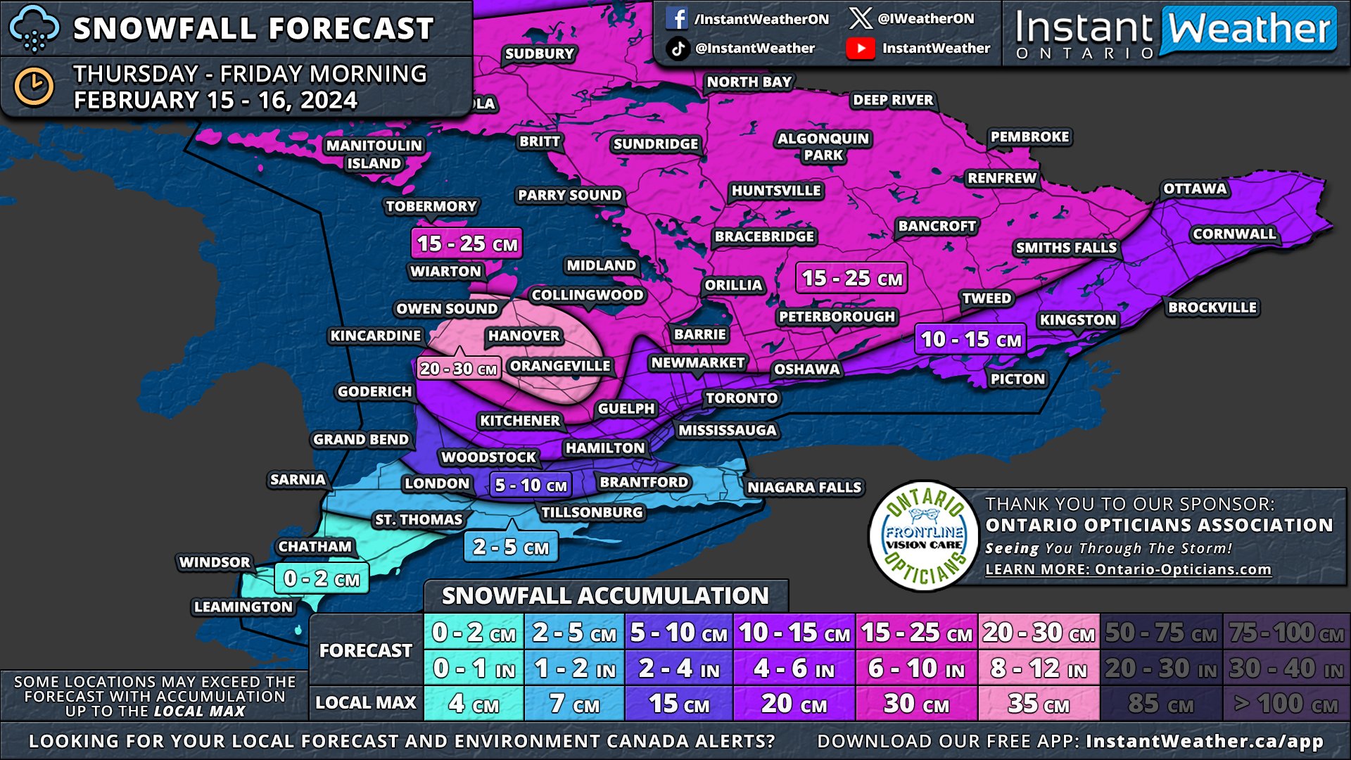
The primary update is that we now anticipate the higher snowfall totals, exceeding 15cm, to be more localized to Central Ontario and the Grey-Bruce region. This is where lake effect snow is expected to enhance snowfall rates. Consequently, we've adjusted the forecast range from 15-25cm down to 15-20cm, as the higher end of the range no longer seems supported by current data. While some areas may still experience local amounts up to 25cm, such occurrences will be relatively isolated.

Areas including Port Elgin, Hanover, and Chatsworth are predicted to see around 20-30cm, combining system snow on Thursday with snow squall activity beginning late Thursday night into Friday. This zone has been narrowed as models provide greater clarity on the specific areas likely to be impacted by snow squall activity.


GOOGLE AD (NOT ENDORSED BY INSTANT WEATHER)

NOTE: YOU CAN CLICK ON THE MAP TO OPEN A ZOOMABLE IMAGE

For locations such as Kitchener, Guelph, Barrie, Peterborough, Smiths Falls, and Ottawa, snowfall totals are projected to be around 10-15cm. In the stretch from the Greater Toronto Area through to Kingston and into Extreme Eastern Ontario, we are forecasting 5 to 10cm of snow. Totals are expected to lean towards the 10cm mark further from the Lake Ontario shoreline, with those in closer proximity likely receiving closer to 5cm.

In the south, anticipated snow amounts for London and Hamilton have been revised downwards from 5-10cm to 2-5cm. Along the Lake Erie shoreline and into Deep Southwestern Ontario, minimal accumulation is expected due to a mix with rain.


earlier forecast

NOTE: YOU CAN CLICK ON THE MAP TO OPEN A ZOOMABLE IMAGE

The snow drought that has held Southern Ontario in its grip for most of February is about to come to an end this Thursday with the arrival of an intense snowmaker. This system is on track to deliver widespread snowfall, with totals ranging from 10 to 25cm, and in some areas, as much as 30cm, thanks to lake effect snow east of Lake Huron.

Accompanying the heavy snow, strong wind gusts of 40-60 km/h are anticipated throughout Thursday. These conditions are likely to cause blowing snow and poor driving visibility, significantly impacting the evening commute across the Golden Horseshoe as well as Central and Eastern Ontario.

The lake effect snow is expected to persist into the weekend, affecting the usual snowbelt areas around Lake Huron and Georgian Bay. It's possible that localized snowfall amounts (including Thursday’s storm) could reach up to 50cm by week's end, particularly in Grey and Bruce counties where lake effect snow is forecasted to be most intense.


GOOGLE AD (NOT ENDORSED BY INSTANT WEATHER)

The system will approach from the west during late Thursday morning, initially impacting areas around Lake Huron before spreading eastward through the afternoon. Deep Southwestern Ontario, including Windsor, Chatham, and the Lake Erie shoreline, might start the day with mixed precipitation, including freezing rain, before transitioning to rain as temperatures rise.

By the afternoon, heavy snow will extend across Central Ontario and into the Golden Horseshoe. There remains some uncertainty regarding the extent of mixed precipitation to the north. Consequently, areas closer to the shoreline, such as Hamilton, Burlington, Brampton, and Toronto, may see some mixed precipitation which would reduce the snowfall totals here.

Central and Eastern Ontario will continue to experience snowfall into Thursday evening. The most challenging conditions are expected during the late afternoon and early evening when both wind and snowfall rates will be at the strongest.

The system is anticipated to gradually exit the province shortly after midnight. However, lake effect snow may develop off Lake Huron and Georgian Bay, with a particularly strong squall likely between Owen Sound and Kincardine overnight. Although expected to weaken by Friday morning, lake-effect snow may still linger throughout the day, especially in Huron, Wellington, Grey, and Bruce counties.


GOOGLE AD (NOT ENDORSED BY INSTANT WEATHER)

NOTE: YOU CAN CLICK ON THE MAP TO OPEN A ZOOMABLE IMAGE

A zone with 20-30cm of snow has been added to the map to cover much of Grey and Bruce counties, including Port Elgin, Hanover, Chatsworth, and Owen Sound, to account for additional lake effect snow following the main system. Localized totals could surpass 30cm, depending on the intensity of the snow squall.

Given the latest data, we have increased confidence to adjust some areas from the 10-20cm zone to the 15-25cm zone, as this system appears to carry more moisture than initially expected. This adjustment affects much of Central Ontario and parts of Eastern Ontario.

Areas like Goderich, Kitchener, the northern Greater Toronto Area, Kingston, and the Ottawa Valley are expected to receive 10 to 15cm of snow as indicated by our earlier forecast. The exact totals here are more uncertain, and isolated pockets may exceed 15cm, depending on moisture distribution.

Near the Lake Ontario shoreline, lower snowfall totals are expected due to potential mixing and temperatures near the freezing mark. Cities such as Toronto, Mississauga, Oakville, Burlington, Hamilton, Woodstock, and London are projected to see 5-10cm of snow, though some locations, especially along the lakeshore, might not reach the 5cm mark.

The Niagara region and Deep Southwestern Ontario, including Sarnia, Chatham, and Windsor, are forecasted to see less than 5cm of snow. While significant snow accumulation isn't expected in these areas, freezing rain could pose a concern during late Thursday morning and early afternoon.


GOOGLE AD (NOT ENDORSED BY INSTANT WEATHER)

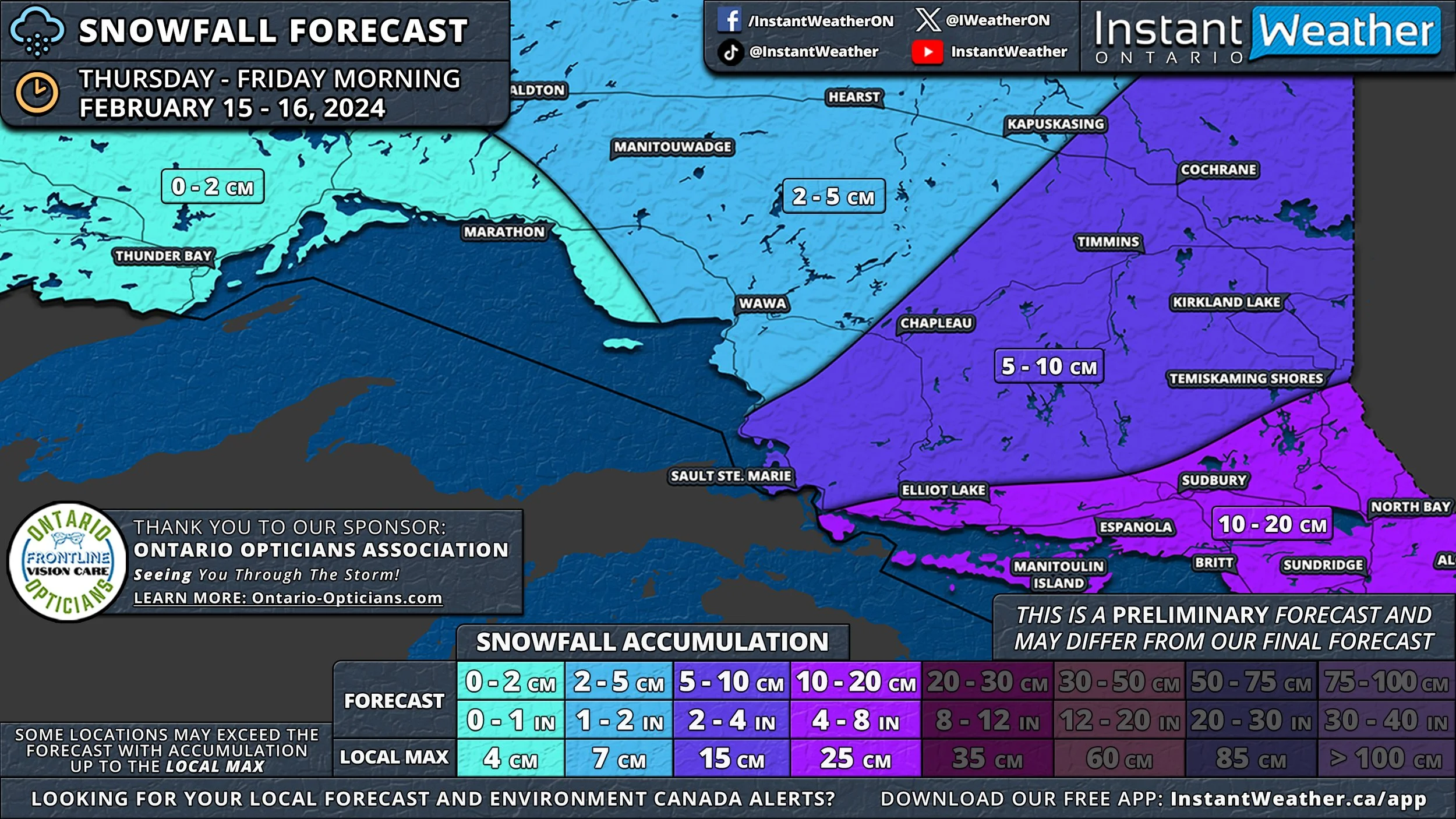
This system will also impact southern parts of Northeastern Ontario, with Elliot Lake, Sudbury, and North Bay set to receive 15 to 25cm of snow. The rest of Northeastern Ontario, including Sault Ste. Marie, Chapleau, Timmins, and Cochrane, can anticipate 5 to 15cm. Northwestern Ontario, including Thunder Bay, is expected to see less than 5cm of snow.

Say It Ain’t Snow! Winter Returns to Southern Ontario With Up to 10-20cm of Snow on Thursday

NOTE: YOU CAN CLICK ON THE MAP TO OPEN A ZOOMABLE IMAGE

February has begun somewhat quietly in terms of active weather across Southern Ontario. The most significant event this month was the record-breaking warmth experienced late last week, with temperatures soaring well into the double digits throughout much of our region. Following Wiarton Willie's bold prediction of an early spring on Groundhog Day, it momentarily seemed as though the famed groundhog was on to something.


GOOGLE AD (NOT ENDORSED BY INSTANT WEATHER)

However, the brief taste of spring was merely an illusion, as more typical seasonal temperatures have since made a comeback. We are now tracking a system that poses the first risk of widespread snowfall for the month. Expected to start early Thursday and continue into Friday, this quick-moving system could bring snowfall totals of 10 to 20cm across much of Central and Eastern Ontario.

This weather system is forecasted to move in from the west during the morning hours on Thursday, beginning with areas around Lake Huron and spreading eastward throughout the afternoon. In Deep Southwestern Ontario, including Windsor, Chatham, and along the Lake Erie shoreline, the day could start with mixed precipitation, including freezing rain, before transitioning to regular rain as warmer air prevails.

There's some uncertainty regarding how far north this mixed precipitation will extend. It could result in lower snowfall totals from London through Hamilton and into parts of the Greater Toronto Area, especially near the shoreline.

Central and Eastern Ontario are set to experience moderate to heavy snow, likely impacting the evening commute on Thursday. As this is a fast-moving system, the majority of the snow is expected to fall within a 6-12 hour period during Thursday afternoon and evening.

The snow should begin to taper off just before midnight. However, lingering flurries and light snow may continue to affect Eastern Ontario into the early hours of Friday, with the system expected to exit Southern Ontario by sunrise on Friday.


GOOGLE AD (NOT ENDORSED BY INSTANT WEATHER)

Due to the dynamic nature of this system, pinpointing exact snowfall totals for each area is challenging, as the moisture content will vary. Currently, a broad swath of Southern Ontario, from the Lake Huron shoreline through Central Ontario and into Eastern Ontario, is projected to receive 10 to 20cm of snow.

It's important to note that the higher end of the 20cm forecast is reserved for isolated areas that may experience lake enhancement, leading to locally heavier snowfall. More commonly, amounts are likely to be closer to 10cm, though some areas may see higher totals.

Snowfall totals are expected to decrease further south, with around 5 to 10cm anticipated for the London, Hamilton, and Toronto regions. This lower accumulation is attributed to the potential for mixed precipitation and lower snowfall ratios.


GOOGLE AD (NOT ENDORSED BY INSTANT WEATHER)

The Windsor, Chatham, Sarnia, and Niagara regions are forecasted to receive less than 5cm of snow due to even greater mixing and limited opportunities for snow accumulation.

This system is also expected to impact the southern part of Northern Ontario, with Elliot Lake, Sudbury, and North Bay poised to see 10 to 20cm of snow. The rest of Northeastern Ontario, including Sault Ste. Marie, Chapleau, Timmins, and Cochrane, can expect around 5 to 10cm. Northwestern Ontario, including Thunder Bay, is forecasted to receive less than 5cm of snow.

Relentless Snow Squalls to Bury Parts of Ontario’s Snowbelt in Up to a METRE (100cm) of Snow by Wednesday

NOTE: YOU CAN CLICK ON THE MAP TO OPEN A ZOOMABLE IMAGE

The coldest air of the season has settled across Southern Ontario, fueling the lake effect machine that has battered parts of the snowbelt over the weekend. Intense squalls have led to significant snowfall, with reports of over 40-50cm in the Orillia and Owen Sound region.

Though these areas saw a respite in squall activity as the bands shifted north last night, the focus now turns to a different part of the snowbelt for the next few days. A strong southwesterly flow over the Great Lakes is expected to continue through Tuesday and into Wednesday leading to continuous snow squall activity.


GOOGLE AD (NOT ENDORSED BY INSTANT WEATHER)

Heavy bands of snow is expected to settle over areas such as Tobermory, Parry Sound, Britt, and Sundridge, potentially burying them in up to 100cm, or 1 meter, of snow in the coming days. A similar situation is unfolding further north, with intense squalls east of Lake Superior, particularly impacting the Wawa area.

Lake Erie and Lake Ontario are also set to bring significant snow to the Southern Niagara Region and Prince Edward County, as squalls spill north of the border, especially by Wednesday morning. This could result in several hours of lake effect snow hammering the Fort Erie and Port Colborne region.

Off Georgian Bay, snow squalls are stretching across the Bruce Peninsula and coming ashore between Parry Sound and Britt. Minor lake-effect snow from Lake Erie and Lake Ontario is expected to continue overnight into Tuesday morning.

A weak system sliding mostly south of the border could be enhanced by the lakes, leading to heavier snow around the Niagara Region and Eastern Ontario, particularly near Kingston. For the rest of Southern Ontario, expect light snow or flurries throughout the morning, leading to a few centimetres of accumulation at most.


GOOGLE AD (NOT ENDORSED BY INSTANT WEATHER)

On Tuesday, the situation for those northeast of Georgian Bay remains unchanged, with intense squalls continuing around Parry Sound, stretching into Sundridge and North Bay. However, by late evening, the southern band may shift to a westerly direction, focusing on the Rosseau and Huntsville area and continuing into Wednesday morning, bringing extreme snowfall totals to northern Muskoka and the Parry Sound region.

For the Niagara region, the Lake Erie squall will remain south of the border for most of Tuesday but is expected to drift north by Wednesday morning. This could significantly impact the Fort Erie and Port Colborne areas with rapid snowfall accumulation and near-zero visibility. Prince Edward County may also experience intense squalls drifting as far north as Belleville and Kingston throughout Wednesday.

Later on Wednesday, intense squalls off Georgian Bay may shift southward into the Port Carling, Bracebridge, and Orillia area. There is some uncertainty regarding the squall's location overnight, but it is expected to continue into Thursday. A separate forecast for the rest of the week will be issued soon.


GOOGLE AD (NOT ENDORSED BY INSTANT WEATHER)

NOTE: YOU CAN CLICK ON THE MAP TO OPEN A ZOOMABLE IMAGE

Forecasting the exact snowfall accumulation for a specific location in a lake-effect snow event is extremely challenging. This is because of the highly localized nature of snow bands, which can lead to significant variance in totals even over short distances.

Therefore, you may notice our forecast shows significantly more snow than your weather app (including our own app). App-based forecasts often struggle with lake effect snow events due to their localized nature and reliance on data focused on larger macro-level weather events. This results in a failure to accurately capture the squalls, which operate at a micro-level, leading to intense snowfall totals.

Our forecast may still be off if the wind direction varies slightly from what the models predict, causing the snow squall band to form further north or south. That's why our forecasts use broader zones to account for this variability, meaning not everyone within these zones will see the significant totals. Essentially, we're indicating that a location within this area could see the forecasted amount.

By late Wednesday, we could be talking about extreme snowfall totals in a zone including Rosseau, Parry Sound, Sprucedale, Burk’s Falls, and Sundridge, with 40 to 80cm of snow expected over the next two days. Local totals could reach triple digits, with 100cm not out of the question if an intense band persists over a particular location.

The Bruce Peninsula and northern Muskoka, including Huntsville, Port Sydney, and North Bay, can expect around 25 to 50cm of snow, although some areas might see less, depending on squall locations. The rest of Muskoka and Algonquin Park are looking at 10-30cm of snow. Central Ontario should see less than 10cm as squalls focus northeast of Georgian Bay.


GOOGLE AD (NOT ENDORSED BY INSTANT WEATHER)

NOTE: YOU CAN CLICK ON THE MAP TO OPEN A ZOOMABLE IMAGE

In the southern Niagara region, including Fort Erie and Port Colborne, snowfall totals could range from 25 to 50cm by Wednesday's end, with most snow coming on Wednesday. Prince Edward County, including Picton, may also see over 25cm of snow in the next few days.

East of Lake Huron, heavier snow is expected in higher elevations away from the shoreline. This includes Owen Sound, Hanover, and Wingham, where between 15-30cm of snow is anticipated, mostly arriving later on Wednesday as more organized lake effect activity begins. Along the shoreline, places like Kincardine and Goderich are forecasted to see less than 10cm of snow.


GOOGLE AD (NOT ENDORSED BY INSTANT WEATHER)

NOTE: YOU CAN CLICK ON THE MAP TO OPEN A ZOOMABLE IMAGE

In Northeastern Ontario, relentless snow squall activity is likely between the Sault Ste. Marie and Wawa corridor, with snowfall totals ranging from 40-80cm. Some spots could far exceed 80cm, particularly just south of Wawa where the squalls will be most intense. Snowfall totals will quickly decrease further away from Lake Superior.


GOOGLE AD (NOT ENDORSED BY INSTANT WEATHER)

Multi-Day Snow Squall Event Could Dump Up to 50cm of Snow on Parts of Ontario’s Snowbelt by Monday

NOTE: YOU CAN CLICK ON THE MAP TO OPEN A ZOOMABLE IMAGE

After the widespread snowstorm brought blizzard conditions and even thundersnow on Friday, attention now shifts to a potential multi-day snow squall event in parts of Ontario. This event is set to start on Saturday evening and continue through Monday.

These squalls could potentially dump over 50cm of snow locally in the typical snowbelt regions around Lake Huron, Georgian Bay, and Lake Superior in the coming days. Notable accumulations are also likely through the Fort Erie and Picton area as squalls from Lake Erie and Lake Ontario occasionally cross the border throughout Sunday.

In addition to the expected significant snowfall, these squalls pose a threat of near-zero visibility, creating dangerous driving conditions in the affected areas. It's advisable to avoid the roads until conditions improve, as the lake effect snow may lead to road closures.


GOOGLE AD (NOT ENDORSED BY INSTANT WEATHER)

Snow squall activity has started off Lake Huron and Georgian Bay as of late Saturday evening. Currently, the lake effect snow is somewhat disorganized, with a thin squall stretching across the Bruce Peninsula into the Muskoka region east of Georgian Bay. Some lake effect activity is also happening south around the Kincardine and Goderich regions.

These squalls are expected to intensify overnight, with colder temperatures leading to more efficient snow accumulation. The worst conditions are anticipated in the entire Grey and Bruce counties east of Lake Huron, extending southward into Huron and Perth counties.

Over Georgian Bay, the area between Bracebridge/Port Carling and south to Orillia/Midland will be the focus. There's a chance a strong squall will establish here, though it's uncertain if it will remain stationary or drift around. If it moves, the snowfall will spread over a larger area, as opposed to localized pockets if it remains stationary.

Early Sunday morning, the Lake Erie squall, currently affecting the Buffalo region, is expected to briefly move north of the border. This will bring heavy snow for a few hours to parts of the Niagara region. The most intense snowfall rates are expected near the Lake Erie shoreline, including Port Colborne and Fort Erie.

Similarly, late Sunday morning, the Lake Ontario band is forecasted to stretch across Prince Edward County to Kingston and possibly as far north as Brockville. While only about 5-10cm of snow is expected, it will occur rapidly, accompanied by whiteout conditions. Such events often lead to crashes on the Hwy 401 corridor between Belleville and Brockville, so extreme caution is advised if travel is necessary during this time.

Both Lake Ontario and Lake Erie squalls will move back south by early afternoon as the wind direction shifts. However, the Lake Huron and Georgian Bay squall will continue to heavily impact Muskoka, Simcoe County, Kawartha Lakes, Grey County, Bruce County, Huron County, and Perth County throughout the afternoon.


GOOGLE AD (NOT ENDORSED BY INSTANT WEATHER)

Some models suggest the Lake Huron squall could stretch far inland at times with a more northwesterly flow, potentially bringing brief heavy snow to the Greater Toronto Area, Kitchener, and Guelph. Sudden reductions in visibility are possible if one of these squalls moves into your area. Areas east of Georgian Bay, including Muskoka and Parry Sound, might get a break from the snow during the afternoon as the intense bands move southward.

By evening, the wind direction is expected to shift back to a westerly direction, leading to the return of squalls in the Muskoka and Northern Simcoe County regions, as well as the Owen Sound, Kincardine, and Wiarton areas for the Lake Huron squall. Additionally, the squalls may return to the Niagara and Picton/Kingston regions after midnight, leading to more heavy snow into early Monday morning.

Our forecast only extends to Monday afternoon due to lower confidence in the exact direction of the squalls beyond that point. However, the risk will certainly continue through Monday and into Tuesday.

Current indications suggest a more southwesterly direction throughout Monday, putting the Parry Sound, Sundridge, and North Bay regions in the path of the intense squall.

The snow squall off Lake Ontario and Erie could remain stationary for many hours through the Niagara region and Kingston area, leading to potentially significant snowfall totals. More details on this will be provided in a separate forecast.


GOOGLE AD (NOT ENDORSED BY INSTANT WEATHER)

NOTE: YOU CAN CLICK ON THE MAP TO OPEN A ZOOMABLE IMAGE

Forecasting the exact snowfall accumulation for a specific location in a lake-effect snow event is extremely challenging. This is because of the highly localized nature of snow bands, which can lead to significant variance in totals even over short distances.

Therefore, you may notice our forecast shows significantly more snow than your weather app (including our own app). App-based forecasts often struggle with lake effect snow events due to their localized nature and reliance on data focused on larger macro-level weather events. This results in a failure to accurately capture the squalls, which operate at a micro-level, leading to intense snowfall totals.

Our forecast may still be off if the wind direction varies slightly from what the models predict, causing the snow squall band to form further north or south. That's why our forecasts use broader zones to account for this variability, meaning not everyone within these zones will see the significant totals. Essentially, we're indicating that a location within this area could see the forecasted amount.

The hardest-hit regions for the Lake Huron squall are expected to be most of Grey and Bruce counties, including Port Elgin, Hanover, Chatsworth, Owen Sound, and Wiarton. Snowfall totals here by Monday afternoon will generally range from 25 to 50cm, with some localized areas possibly exceeding this mark depending on the intensity of the squall activity.

For those east of Georgian Bay, the highest snowfall totals are likely in Southern Muskoka and Northern Simcoe County. Again, snowfall totals in locations such as Midland, Washago, Gravenhurst, Bracebridge, and Port Carling will range from 25 to 50cm, with some areas potentially exceeding 50cm.

The accumulation will quickly decrease away from the main regions, as this event is very localized. Around 15 to 30cm of snow is expected for places like Parry Sound, Haliburton, Orillia, Collingwood, Shelburne, Huron County, and Perth County. Further out, locations such as Kawartha Lakes, Wasaga Beach, Fergus, and Goderich could see 10 to 25cm of snow.

Less than 15cm is possible for the surrounding areas, with most places seeing less than 5cm. However, some areas could receive more if they encounter a brief snow squall. This includes Barrie, Kitchener, Guelph, the Greater Toronto Area, and Peterborough.


GOOGLE AD (NOT ENDORSED BY INSTANT WEATHER)

NOTE: YOU CAN CLICK ON THE MAP TO OPEN A ZOOMABLE IMAGE

In the Niagara region, the highest totals will be along the Lake Erie shoreline, including Fort Erie, Port Colborne, and Turkey Point, with up to 15-30cm possible. Most of this snow will fall early Sunday morning and later in the evening.

The forecasted totals will decrease rapidly the further away from Lake Erie you are. Welland could see around 10-20cm, while Niagara Falls might get 5-10cm. St. Catharines is expected to be less affected, with maybe 5cm of snow possible.

In Eastern Ontario, Picton, Napanee, and Kingston will see the most snow from Lake Ontario. The hardest-hit areas are currently projected to receive around 10-15cm, although the southernmost tip of Prince Edward County could approach 20cm.

Along the International Border into Brockville, up to 5-10cm of snow is expected from the squall moving across the area late Sunday morning.


GOOGLE AD (NOT ENDORSED BY INSTANT WEATHER)

NOTE: YOU CAN CLICK ON THE MAP TO OPEN A ZOOMABLE IMAGE

Intense snow squalls are also ongoing south of Lake Superior and are expected to move north of the border during Sunday afternoon. This will result in rapid snow accumulation east of Lake Superior, somewhere between Wawa and Sault Ste. Marie.

Snow squall activity in this region is expected to continue into Monday and even Tuesday. By Monday afternoon, the hardest-hit areas, including Sault Ste. Marie, will see totals ranging from 25 to 50cm. Additional snowfall late Monday into Tuesday will add to these totals.

Further east, the Chapleau and Elliot Lake regions could also experience heavy lake effect snow, with around 10-20cm of accumulation possible. The rest of Northeastern Ontario should see around 5-15cm, with lower totals further away from the lake.


GOOGLE AD (NOT ENDORSED BY INSTANT WEATHER)

Intense Blast of Snow on Friday Evening Could Bring Blizzard Conditions & Up to 20-30cm of Snow to Parts of Ontario

NOTE: YOU CAN CLICK ON THE MAP TO OPEN A ZOOMABLE IMAGE

Confidence remains high regarding a snowstorm set to impact Southern and Northeastern Ontario from late Friday into Saturday. Despite a slight reduction in the predicted snowfall totals, we're still on track for a high-impact event. This event will feature several hours of intense snowfall and strong wind gusts, which are likely to result in blizzard conditions and blowing snow.

Currently, we're anticipating a widespread snow accumulation of 15-30cm across Southern Ontario. However, areas closer to the Lake Ontario and Erie shorelines may see lower amounts, as a switch to rain is expected to limit the overall accumulation.


GOOGLE AD (NOT ENDORSED BY INSTANT WEATHER)

There's a degree of uncertainty regarding the extent of warm air intrusion, leading to discrepancies in the snowfall totals projected by different models. To account for this variance, we've opted for broader snowfall ranges instead of predicting a definitive outcome of either warm or cold air dominance.

The likelihood of warmer air influencing the weather, followed by a rapid cooldown early Saturday, introduces the risk of a flash freeze. Areas along the Lake Erie and Ontario shorelines might experience slushy conditions late Friday night due to temperatures rising to the mid-single digits and mixing with rain. This slush is expected to freeze quickly as colder air moves in behind the system, potentially leading to icy road conditions on Saturday morning.

We expect the storm's initial band of snow to hit between 4-6 PM on Friday, starting in Extreme Southwestern Ontario. This band is poised to deliver a short, intense burst of heavy snowfall, with rates of 4-8cm per hour, possibly accompanied by thundersnow.

Accompanying strong wind gusts, which could reach up to 90km/h in some localities, are expected to create hazardous driving conditions, particularly in Southwestern Ontario, the Golden Horseshoe, and parts of Central Ontario, where localized blizzard conditions may occur.

This heavy snow will progress through Southwestern Ontario, impacting London, Kitchener, and Hamilton by early evening. It will reach the Greater Toronto Area later in the evening, and eventually spread northeast to Central and Eastern Ontario, continuing overnight into early Saturday.

While the most intense snowfall will be brief, moderate snow is expected to persist behind the initial band throughout the night into Saturday. Around the Lake Ontario and Erie shorelines, a surge of warmer air Friday night into Saturday morning could result in a temporary changeover to rain, especially affecting snowfall totals in the Niagara region and parts of the Greater Toronto Area near the lakeshore.


GOOGLE AD (NOT ENDORSED BY INSTANT WEATHER)

There's increased confidence that warmer air will move in along the Lake Erie and Ontario shorelines after the intense snow band passes in the evening. This could lead to reduced snowfall totals in the Niagara region and parts of the Greater Toronto Area (GTA) near the lakeshore.

Higher-resolution models suggest that snowfall accumulation may vary significantly based on elevation. Therefore, areas like the Dundalk Highlands and along the Oak Ridges Moraine north of the GTA are likely to receive higher snowfall totals.

Steady snowfall is expected to persist throughout Southern Ontario on Saturday, with the most intense snow occurring in Eastern Ontario. The arrival of much colder air in the wake of the system will also trigger lake-effect snow squalls off Georgian Bay and Lake Huron.

These snow squall conditions are expected to continue into the next week, with the cold Arctic air remaining over our region. This could result in significant snowfall accumulations throughout the week in areas including Goderich, Kincardine, Hanover, Owen Sound, Wiarton, Barrie, Orillia, Midland, Bracebridge, Huntsville, Parry Sound, Britt, and Sundridge.

It's important to note that snowfall totals from this event will be highly variable, influenced by local factors that are difficult to precisely predict. Therefore, app-based forecasts, including ours, may vary from the forecast presented here. Our approach involves providing a broader range to account for various potential scenarios.


GOOGLE AD (NOT ENDORSED BY INSTANT WEATHER)

NOTE: YOU CAN CLICK ON THE MAP TO OPEN A ZOOMABLE IMAGE

We believe the hardest-hit regions will be parts of Eastern Ontario, specifically between Peterborough and Ottawa. The entrenched colder air in this area is expected to prevent any mixing, leading to significant snowfall.

The intense snow band on Friday could stall over Eastern Ontario for several hours, weakening gradually. Snowfall totals in this region are anticipated to range from 20 to 35cm, though localized areas could receive up to 40cm by the end of Saturday.

Central and Eastern Ontario, away from the Lake Ontario shoreline, are projected to receive about 15 to 25cm of snow. However, local accumulations could exceed 30cm, particularly in elevated regions through Orangeville, Shelburne, and York Region.

Areas around Georgian Bay, including Barrie, Orillia, and Muskoka, are expected to underperform in terms of snow accumulation. We're forecasting 10 to 20cm to account for this potential dry slot.

NOTE: YOU CAN CLICK ON THE MAP TO OPEN A ZOOMABLE IMAGE

The forecast becomes more complex further southeast into the Golden Horseshoe. Away from the shorelines of Lake Erie and Ontario, snowfall totals are likely to exceed 10cm and could approach 20cm in some areas.

Closer to the shorelines, we anticipate accumulation ranging from 5 to 15cm. This broad range accounts for the uncertainty, with areas right along the shoreline likely seeing closer to 5cm, while a few kilometres inland could receive up to 15cm.


GOOGLE AD (NOT ENDORSED BY INSTANT WEATHER)

NOTE: YOU CAN CLICK ON THE MAP TO OPEN A ZOOMABLE IMAGE

The tight gradient makes it challenging to represent on a map, hence the larger range. This 5 to 15cm range also applies to much of Deep Southwestern Ontario, including Windsor and Sarnia, with most of the snowfall occurring within a few hours late Friday afternoon.

The Lake Erie shoreline into the Hamilton region is expected to receive less than 10cm of snow. Meanwhile, the Niagara region might see the least amount, with less than 5cm possible.

NOTE: YOU CAN CLICK ON THE MAP TO OPEN A ZOOMABLE IMAGE

In Eastern Ontario, significant snowfall totals are expected to be widespread, with the 20-35cm zone southwest of Ottawa. The City of Ottawa itself is likely to see around 15 - 25cm, though totals approaching 30cm cannot be discounted.

Further southeast, the warm air will influence snowfall in the Kingston, Brockville, and Cornwall areas early Saturday morning, likely limiting totals to a general 10-20cm. However, areas right along the international border, including Cornwall and Brockville, might not even reach the 10cm mark.


GOOGLE AD (NOT ENDORSED BY INSTANT WEATHER)

NOTE: YOU CAN CLICK ON THE MAP TO OPEN A ZOOMABLE IMAGE

Northeastern Ontario is also set to be affected by this event, with over 20cm of snow forecasted starting late Friday evening. The heaviest band of snow is expected to move across Manitoulin Island and into the Sudbury region early Saturday morning, with snowfall rates of 3-6cm per hour.

Blowing snow and localized blizzard conditions are a concern during the morning hours across the southern portion of Northeastern Ontario, including Sudbury and North Bay. Moderate snowfall is expected to continue across Northeastern Ontario throughout Saturday, tapering off later in the evening.

The highest totals are forecasted from Manitoulin Island through Elliot Lake, Sudbury, and North Bay, with 20 to 35cm of snow possible. Locally, up to 40cm can't be ruled out, especially given the intensity of the morning snowfall.

Less snow is expected further northeast, with around 10-20cm for Sault Ste. Marie, Chapleau, and Timmins. Even lower amounts, ranging from 5 to 15cm, are possible from Wawa to Kapuskasing.


GOOGLE AD (NOT ENDORSED BY INSTANT WEATHER)

Winter Storm Threatens Tuesday Evening Commute Across Ontario Including the GTA; Significant Snowfall to the North With Up to 35cm Possible

NOTE: YOU CAN CLICK ON THE MAP TO OPEN A ZOOMABLE IMAGE

The New Year in Ontario has been notably active, marked by several snowy systems over the past week. This trend is expected to continue with a significant winter storm approaching, bringing heavy snow, ice pellets, and some freezing rain beginning Tuesday morning.

We are also closely monitoring a potential high-impact storm this weekend, which may deliver a more substantial impact, focusing on heavy snow rather than mixed precipitation.

More details about the looming snowstorm threat will be provided in the coming days. For now, our attention is on the imminent winter storm, which presents a complex forecast involving various winter weather threats. Weather models have struggled to determine the exact path of this system, but there is broad agreement as we approach 24 hours before the system's arrival.


GOOGLE AD (NOT ENDORSED BY INSTANT WEATHER)

The heaviest snowfall is expected to occur primarily in Northeastern Ontario, extending southward into Central and Eastern Ontario. In these areas, precipitation is likely to remain frozen for most of the event, resulting in higher snowfall totals. By early Wednesday, the hardest-hit areas could see over 20cm of snow, with some locales receiving more than 30cm.

In the rest of Southern Ontario, the scenario is more complex. We anticipate wet snow in most regions on Tuesday morning, transitioning to rain as temperatures rise, beginning in Deep Southwestern Ontario and around the Lake Huron shoreline.

The speed of the warmer air's advance northward creates uncertainty regarding overall snowfall accumulation. Strong wind gusts accompanying the icy mix may reduce visibility and cause blowing snow.

By Tuesday afternoon and evening, a large portion of Southwestern Ontario and the Golden Horseshoe is expected to shift to ice pellets and then rain. This transition may coincide with peak evening rush hour, potentially leading to hazardous travel conditions. We advise preparing for extended travel times or considering staying off the roads until conditions improve.


GOOGLE AD (NOT ENDORSED BY INSTANT WEATHER)

NOTE: YOU CAN CLICK ON THE MAP TO OPEN A ZOOMABLE IMAGE

To clarify the timeline of the various precipitation shifts, we will detail the expected impact of this winter storm for each part of Tuesday and Wednesday.

Focusing on the timeline rather than the amounts is crucial, as accumulating snow at the storm's onset will likely be washed away by rain, making accurate measurement challenging. The rapid shifts in precipitation types, leading to icy and slushy road conditions, are the main threat of this winter storm.

The storm will begin early Tuesday morning as initial bands of precipitation cross into Deep Southwestern Ontario. Heavy wet snow is expected in Windsor, Chatham, Sarnia, London, and the Niagara region, transitioning to rain by late morning.

Further north, colder air will result in more prolonged snow across the Golden Horseshoe and westward through the Kitchener region. Ice pellets may mix in, especially along the Lake Ontario shoreline and south of the Hwy 401 corridor.


GOOGLE AD (NOT ENDORSED BY INSTANT WEATHER)

NOTE: YOU CAN CLICK ON THE MAP TO OPEN A ZOOMABLE IMAGE

As the afternoon progresses, the storm will intensify across Southern Ontario. Areas in Deep Southwestern Ontario and along the Lake Erie shoreline into the Niagara region will have switched to rain, minimizing the impact.

There is uncertainty in the Lake Huron shoreline and the Greater Toronto Area, where precipitation types will vary due to slight temperature differences.

Areas closest to the shoreline, including Hamilton, Burlington, Mississauga, and Toronto, will see a mix of ice pellets and snow during the early afternoon. However, by late afternoon, some rain is expected to mix in.

Regions north of the Hwy 401 corridor are likely to experience continued heavy snow mixed with ice pellets at times. Combined with strong wind gusts of 60-80km/h, travel could be difficult due to blowing snow and ice pellets.

A slight risk of brief freezing rain exists in this area, although sustained freezing rain is unlikely. The more likely progression will be from snow to ice pellets to rain.

Heavy snow will also affect Central Ontario around Lake Simcoe and eastward along the Lake Ontario shoreline into Eastern Ontario. Expect several hours of heavy snow throughout the afternoon.

Those in the Quebec border area and the Ottawa Valley will see the first snow bands by late afternoon, starting with lighter snow and intensifying later.


GOOGLE AD (NOT ENDORSED BY INSTANT WEATHER)

NOTE: YOU CAN CLICK ON THE MAP TO OPEN A ZOOMABLE IMAGE

By evening, warmer air will begin to replace the cold air, leading to a wider transition from frozen precipitation to rain. Southwestern Ontario and the Golden Horseshoe will have mostly switched to rain.

In southern parts of Central and Eastern Ontario, snow will persist into the early evening, potentially mixing with rain near midnight.

Heavy snow will continue for the Quebec border and Ottawa Valley regions throughout the evening. Ice pellets may mix in, extending from north of Parry Sound through Huntsville to the Smiths Falls and Cornwall areas.

Northeastern Ontario is expected to see persistent heavy snow from late Tuesday afternoon through the night. Little mixing is anticipated in this area.


GOOGLE AD (NOT ENDORSED BY INSTANT WEATHER)

NOTE: YOU CAN CLICK ON THE MAP TO OPEN A ZOOMABLE IMAGE

The storm will persist into early Wednesday, primarily affecting northern parts of Central and Eastern Ontario. South of a line from Bracebridge to Smiths Falls is expected to switch to rain by midnight.

Heavy snow will continue in the Ottawa Valley and Northeastern Ontario. By mid-morning, some mixing, including ice pellets and potentially freezing rain, is expected.

By sunrise, most of Southern Ontario will have switched to rain, while snow continues in Northeastern Ontario. The Ottawa region may not experience this transition if warmer temperatures fail to displace the cold air. Wednesday morning's commute in Eastern Ontario, especially the Ottawa Valley, is likely to be challenging.

As the system leaves the region, temperatures are expected to drop below freezing by early Wednesday morning in Southwestern Ontario and late morning or early afternoon in the rest of Southern Ontario. This will result in a transition back to wet flurries later on Wednesday, although significant accumulation is unlikely.


GOOGLE AD (NOT ENDORSED BY INSTANT WEATHER)

NOTE: YOU CAN CLICK ON THE MAP TO OPEN A ZOOMABLE IMAGE

While the variety of precipitation types is a key story of this storm, overall snowfall accumulation in some areas will resemble a classic snowstorm rather than a messy winter storm.

Starting with the least affected region, Deep Southwestern Ontario and the Niagara region are expected to see less than 5cm of snowfall, primarily on Tuesday morning before being washed away by rain.

Snowfall totals along the Hwy 401 corridor from London through Hamilton to the GTA are expected to be around 5 to 10cm early on Tuesday before switching to rain. This forecast is tricky, as slight temperature variations can significantly affect snowfall amounts. Thus, focus less on specific amounts in this region.

Areas north of the Hwy 401 corridor and away from the Lake Ontario shoreline are likely to see prolonged heavy snow throughout Tuesday morning and afternoon. Snowfall totals could reach 10-15cm in some areas, especially in higher elevations around the Dundalk Highlands, Kitchener, and Guelph regions, where some models suggest localized totals may exceed 15cm.


GOOGLE AD (NOT ENDORSED BY INSTANT WEATHER)

This zone, encompassing much of southern Central and Eastern Ontario, has more variance, leading to a wider range of 5cm to 15cm in snowfall totals. This forecast acknowledges the uncertainty in this area, providing a complete picture rather than a definitive prediction.

Further north, snowfall totals of 10 to 20cm are expected from Parry Sound through Muskoka to the Tweed and Cornwall areas.

Even higher totals are anticipated in northern Central Ontario, including Sundridge, Bancroft, and the Ottawa Valley, with a general range of 15-25cm possible. Localized pockets may even see up to 30cm.

The Algonquin Park, Renfrew, and Pembroke areas are forecasted to be the worst hit in Southern Ontario, with expected snowfall between 20 to 35cm.


GOOGLE AD (NOT ENDORSED BY INSTANT WEATHER)

In addition to snowfall, significant rain and wind are associated with this system, particularly in the south. Rainfall totals will range from 30 to 50mm across Deep Southwestern Ontario, along the Lake Erie shoreline, and into parts of Eastern Ontario north of Lake Ontario.

Rainfall totals will decrease further north, with around 20 to 30mm expected along the Lake Huron shoreline and into the GTA near Lake Ontario. For southern parts of Central and Eastern Ontario, rainfall totals between 10 to 20mm are expected, but actual precipitation will be higher when melted snow is considered, raising flooding concerns.

Less than 10mm of rain is anticipated for more northern parts of Central and Eastern Ontario, as they are likely to remain predominantly on the cold side of the storm.

Strong to damaging wind gusts are also a risk during Tuesday afternoon and evening. While there is some disagreement on the intensity, some models suggest gusts could approach 90-100km/h around the Lake Erie shoreline, Niagara region, and Prince Edward County.

For the rest of Southwestern Ontario into the Golden Horseshoe, wind gusts will range from 50 to 70 km/h, with a slight chance of 70-85 km/h gusts if the more intense model proves accurate.


NOTE: YOU CAN CLICK ON THE MAP TO OPEN A ZOOMABLE IMAGE

For Northeastern Ontario, the event will primarily be a snowstorm, starting Tuesday afternoon and continuing into Wednesday afternoon.

Snowfall totals are expected to be significant, with the hardest-hit regions from Manitoulin Island through Sudbury, North Bay, and into the Kirkland Lake region anticipating 20 to 35cm, with some areas possibly reaching 40cm.

Lower amounts are forecasted further west, with 15 to 25cm expected in areas including Elliot Lake, Timmins, and Cochrane.

Closer to Lake Superior, including Sault Ste. Marie, Wawa, and Kapuskasing, around 10 to 15cm of snow is expected, although this may vary by location. For a more detailed forecast, refer to the accompanying map.

In summary, this winter storm brings a mix of precipitation types across Ontario, with varying impacts depending on the region. The forecast includes heavy snow, rain, and strong winds, with significant snowfall in certain areas. Residents should stay informed and prepare for potentially hazardous travel conditions.