Saskatchewan: Thunderstorm Forecast for Sunday, June 18, 2023

NOTE: YOU CAN CLICK ON THE MAP TO OPEN A ZOOMABLE IMAGE WHICH WILL BE EASIER TO READ.


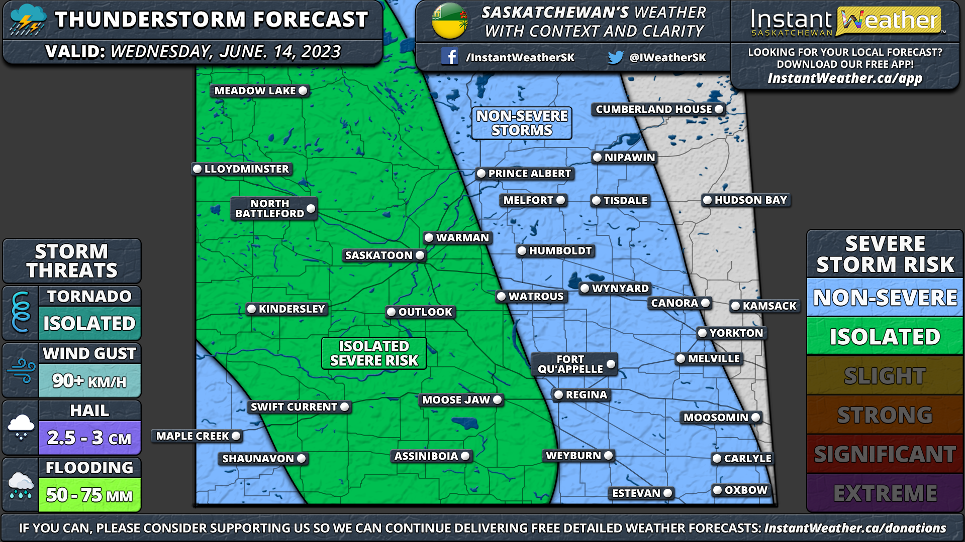
A line of strong to severe thunderstorms is expected to develop in Southwestern Saskatchewan during the early afternoon hours on Sunday. This line will slowly track to the northeast throughout the day and could being damaging wind gusts to much of Central Saskatchewan including Moose Jaw, Regina and Saskatoon. The main risk associated with these storms will be wind gusts up to 100 km/h and quarter-sized hail.

The overall tornado threat is low, however, there are some indications that the environment will be favourable for the development of funnel clouds. These funnel clouds typically don’t pose a threat to those on the ground, but they can touch down and become a landspout tornado in rare cases.

Landspout: A landspout is a type of tornado that forms under a weak thunderstorm. Unlike traditional tornadoes, which develop from supercell thunderstorms and are associated with a rotating updraft called a mesocyclone, landspouts form from non-supercell storms and do not have a mesocyclone. These tornadoes are generally weaker and shorter-lived than their supercell counterparts but can still pose a threat to property and life, with wind speeds occasionally reaching up to 160 km/h.

Saskatchewan: Thunderstorm Forecast for Saturday, June 17, 2023

NOTE: YOU CAN CLICK ON THE MAP TO OPEN A ZOOMABLE IMAGE WHICH WILL BE EASIER TO READ.


Thunderstorm activity is expected to be widespread across much of Saskatchewan during the afternoon and evening on Saturday. At the moment it appears that the storms should remain non-severe. Although the environment is favourable in the more southern part of the province including Swift Current, Moose Jaw and Region for potential funnel clouds. These funnel clouds don’t typically pose a threat to those on the ground, but in rare cases, they can touch the ground and become a landspout tornado.

Landspout: A landspout is a type of tornado that forms under a weak thunderstorm. Unlike traditional tornadoes, which develop from supercell thunderstorms and are associated with a rotating updraft called a mesocyclone, landspouts form from non-supercell storms and do not have a mesocyclone. These tornadoes are generally weaker and shorter-lived than their supercell counterparts but can still pose a threat to property and life, with wind speeds occasionally reaching up to 160 km/h.

Saskatchewan: Thunderstorm Forecast for Thursday, June 15, 2023

NOTE: YOU CAN CLICK ON THE MAP TO OPEN A ZOOMABLE IMAGE WHICH WILL BE EASIER TO READ.


Thunderstorms are currently not expected across Saskatchewan on Thursday.

Saskatchewan: Thunderstorm Forecast for Wednesday, June 14, 2023

NOTE: YOU CAN CLICK ON THE MAP TO OPEN A ZOOMABLE IMAGE WHICH WILL BE EASIER TO READ.


Widespread thunderstorm activity is expected primarily across Western and Central Saskatchewan on Wednesday. Some of these storms may reach severe levels with 90 km/h wind gusts, toonie-sized hail and an isolated tornado can’t be ruled out. The strongest risk will be during the afternoon and early evening hours as the storms track eastward after developing near the Alberta border.

Saskatchewan: Thunderstorm Forecast for Tuesday, June 13, 2023

NOTE: YOU CAN CLICK ON THE MAP TO OPEN A ZOOMABLE IMAGE WHICH WILL BE EASIER TO READ.


A few isolated pop-up storms may develop in much of Eastern, Central and Western Saskatchewan during the afternoon and evening on Tuesday. There is an isolated chance that one to two of these storms reach severe levels with quarter-sized hail and damaging wind gusts in Southeastern Saskatchewan along the Manitoba border.

Saskatchewan: Thunderstorm Forecast for Monday, June 12, 2023

NOTE: YOU CAN CLICK ON THE MAP TO OPEN A ZOOMABLE IMAGE WHICH WILL BE EASIER TO READ.


FORECAST DISCUSSION

Isolated non-severe thunderstorms are possible in parts of Western and Central Saskatchewan on Monday. The potential for storms includes Kindersley, North Battleford, Saskatoon, Outlook, Warman, Watrous, Melfort and Prince Albert.

Saskatchewan: Thunderstorm Forecast for Wednesday, June 7, 2023

NOTE: YOU CAN CLICK ON THE MAP TO OPEN A ZOOMABLE IMAGE WHICH WILL BE EASIER TO READ.

Isolated thunderstorm activity is expected across much of South-central and Eastern Saskatchewan on Wednesday. It will be more concentrated in Southeastern Saskatchewan where some of these storms could reach severe levels with 90+ km/h wind gusts and up to quarter-sized hail. The environment is also favourable for the development of funnel clouds and maybe even a landspout.

Landspout: A landspout is a type of tornado that forms under a weak thunderstorm. Unlike traditional tornadoes, which develop from supercell thunderstorms and are associated with a rotating updraft called a mesocyclone, landspouts form from non-supercell storms and do not have a mesocyclone. These tornadoes are generally weaker and shorter-lived than their supercell counterparts but can still pose a threat to property and life, with wind speeds occasionally reaching up to 160 km/h.

Saskatchewan: Thunderstorm Forecast for Tuesday, June 6, 2023

NOTE: YOU CAN CLICK ON THE MAP TO OPEN A ZOOMABLE IMAGE WHICH WILL BE EASIER TO READ.

Thunderstorms are possible across much of Southern Saskatchewan on Tuesday. Some of these storms could reach severe levels with large hail, damaging wind gusts and heavy rainfall. The strongest risk stretches from Shaunavon through Moose Jaw, Saskatoon and into Melfort. An isolated tornado can’t be ruled out.

We have added a more focused ‘slight’ risk zone within this larger isolated severe risk zone. This is because the latest data indicate a fairly strong wind and hail potential which merits an upgrade to slight risk.

Saskatchewan: Thunderstorm Forecast for Monday, June 5, 2023

NOTE: YOU CAN CLICK ON THE MAP TO OPEN A ZOOMABLE IMAGE WHICH WILL BE EASIER TO READ.

Widespread storm activity is expected across Western Saskatchewan on Monday. Some of these storms have the potential to reach severe levels with large hail, damaging wind gusts and heavy rainfall. The best chance for storms is right along the Alberta border as we see storms crossing into the province from Alberta by the late afternoon and evening. An isolated tornado can’t be ruled out, but the environment isn't too favourable for tornadoes so we’ll keep it an isolated risk for now.

Non-severe storms are also possible in the Eastern section along the Manitoba border where a landspout tornado risk also exists.

Saskatchewan: Thunderstorm Forecast for Saturday, June 3, 2023

NOTE: YOU CAN CLICK ON THE MAP TO OPEN A ZOOMABLE IMAGE WHICH WILL BE EASIER TO READ.

The busy weather week continues across Saskatchewan with yet another expansive severe weather risk on Saturday. Our focus for this round of storms will shift more to the northwest around the Kindersley, Saskatoon and Prince Albert regions.

Beginning with isolated cells including the potential for supercells during the late afternoon and early evening. These storms will primarily present a large hail (up to toonie to even golf ball size) and damaging wind gust threat. As we head later into the evening, the threat will shift more to the strong wind gusts as the storms merge into a line and begin to ‘bow’ out.

TORNADO RISK

With the risk of supercells, also comes the potential for tornadoes. Based on the environment, we believe that one or two tornadoes are possible in a zone including Kindersley, Outlook, Saskatoon, Warman, Watrous, Humboldt and Melfort.

Much of Central Saskatchewan has an isolated risk of a tornado, but it’s questionable. The tornado threat will be highest around the dinner hour with it diminishing later in the evening.

Saskatchewan: Thunderstorm Forecast for Saturday, June 3, 2023

NOTE: YOU CAN CLICK ON THE MAP TO OPEN A ZOOMABLE IMAGE WHICH WILL BE EASIER TO READ.

Widespread thunderstorm activity is expected during the day on Saturday across Saskatchewan. A few of these storms may reach severe levels with 90 km/h wind gusts and quarter-sized hail. An isolated tornado can’t be ruled out either, particularly further to the north around Melfort and Prince Albert where the environment is the strongest.

Saskatchewan: Thunderstorm Forecast for Friday, June 2, 2023

NOTE: YOU CAN CLICK ON THE MAP TO OPEN A ZOOMABLE IMAGE WHICH WILL BE EASIER TO READ.

Widespread severe thunderstorms are expected across much of Southern Saskatchewan during the afternoon and evening on Friday. Current data suggest that isolated cells will pop up during the mid to late afternoon hours somewhere around Estevan and Weyburn. Based on the environment, we believe these storms have the potential to quickly reach severe levels with damaging wind gusts and large hail.

In addition to this, the storms will also be moving quite slowly so flooding could be an issue, especially in more urban areas such as Regina. We may need to introduce a ‘strong’ severe risk zone due to the hail and wind risk, however, confidence isn’t high enough at this time. We will re-evaluate that in the morning and will update our forecast if we feel it’s warranted

TORNADO RISK

The environment is also favourable for a few brief spin-ups especially in the Weyburn and Regina region when the storms are early in their lifespan. As such, we think there is a good chance that we see at least one tornado associated with these storms on Friday, but of course it isn’t guaranteed. The tornado threat will weaken later in the day as the storm mode become more linear and transitions over a strong wind gust threat.

Saskatchewan: Thunderstorm Forecast for Friday, June 2, 2023

NOTE: YOU CAN CLICK ON THE MAP TO OPEN A ZOOMABLE IMAGE WHICH WILL BE EASIER TO READ.

Widespread severe thunderstorms are expected across much of Southern Saskatchewan during the afternoon and evening on Friday. These storms have the potential to produce large hail and damaging wind gusts. We believe there is a good chance for one or two tornadoes somewhere in South-central Saskatchewan based on the environment.

We may need to introduce a ‘strong’ severe risk zone due to the hail and wind risk, however, confidence isn’t high enough at this time. We will re-evaluate that during our Thursday evening update.