37 YEARS AGO, TODAY: 14 Tornadoes Touched Down, Including Two F4's & The Longest Track Tornado in Canadian History (Fri, May 31, 1985)
/On Friday, May 31st, 1985, 14 tornadoes touched down across southern Ontario, killing 12 and injuring hundreds. Our thoughts and deepest condolences are with the families and friends of those who were lost, injured, and forever affected that day.
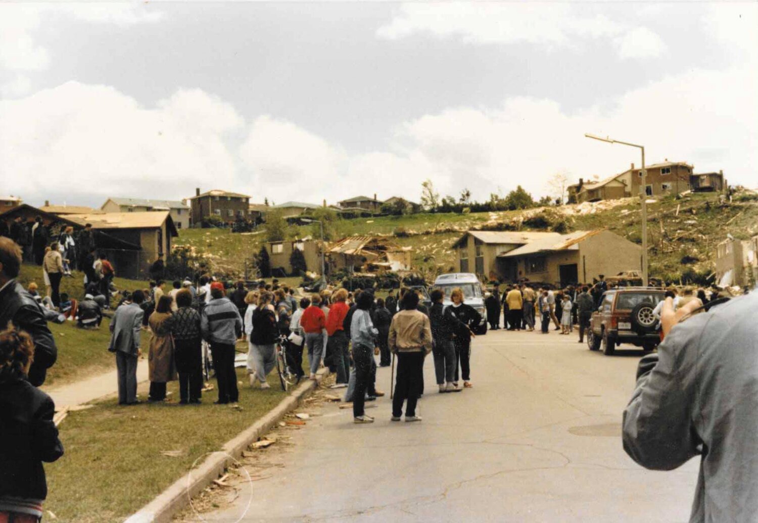
Our long time community member Jennifer D. came across 18 previously unseen photos from Barrie and shared her story online about what she experienced:
”May 31, 1985. We lived at the corner of Ardagh and Essa (currently where Big B Comics is). My mom and my aunt had my sister and I out doing groceries at the IGA at Essa and Tiffin. A two minute drive home, we pulled in the driveway and the sky went black. I was two and a half and I ran into the house to wake up my Dad who worked midnights and was sound asleep. My Mom grabbed Katie from the car who was only three months old and ran into the house. We went to the basement while the tornado roared over top of us-all of us except Dad. He slept through the whole thing!!! He could prob still sleep though one.
These are some pictures Mom and Dad took of the aftermath from the area. You can see Ardagh, Essa, Fairview and Innisfil as well as the racetrack. So crazy! I still have nightmares of tornadoes”
Thank you so much for sharing your experience and photos with us Jennifer and we’re so glad that you and your family stayed safe! Here are Jennifer’s photos below:


Below is an image where we combined the 14 official tornado tracks created by Dr. David Sills (Northern Tornadoes Project) with major city and town names for comparison:

Below is the actual radar image from 4:20 PM on May 31st, 1985. In this image, we compared the radar data to the official damage paths from Environment Canada. This wasn't a squall line folks, this was a 'multi-cell supercell' that ended up becoming the most prolific tornado producing storm in our province's history:

The image below is looking east in 3D at all 3 major tornado tracks at once with radar underneath. Three violent Tornadoes, two F4's and one F3 on the ground all at the same time, tracking east through our region at 105 km/h:

Here is several zoomed images of all 14 confirmed tornadoes with some major city names for comparison. Below is the Hopeness F2 Tornado, northwest of Owen Sound (3pm):

The birth of the storm that would eventually produce the Barrie F4 tornado after lifting and changing strength several times. This image includes the tracks of the F2 in Hopeville at 4:10pm, F3 in Corbetton at 4:17pm and F2 in Lisle at 4:50pm:

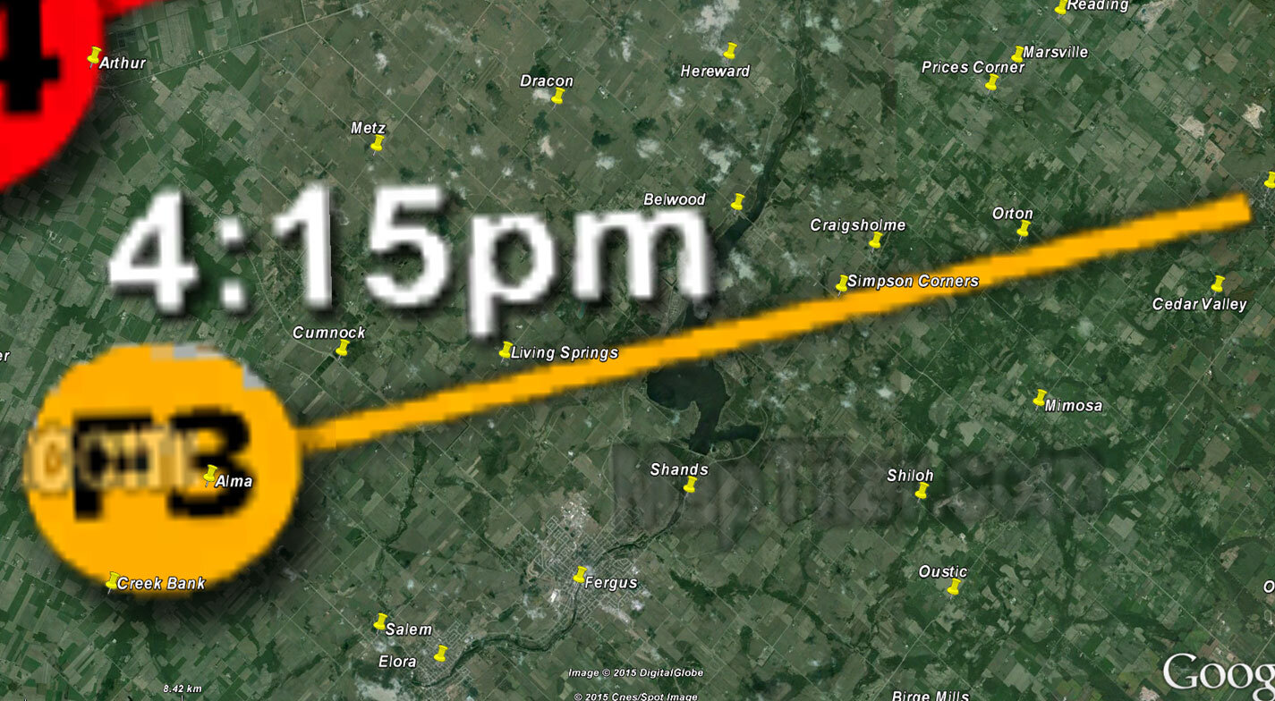
Below is the Grand Valley F4 (4:15pm) tornado track in red. Everyone talks about the Barrie tornado when referring to 1985 and for good reason; 8 people lost their lives and more than 100 were injured. But lets not forget the record-setting, long-track violent tornado that was the 'Grand Valley' F4 Tornado. It holds the record for the longest track tornado in Canadian history at 115km. And remember, these Tornadoes were racing forward at 105km/h so it was on the ground for more than an hour. It also tragically took the lives of 4 and injured 300.

While we’re on the topic of the Grand Valley F4, have you ever heard the tale about a house being carried by a tornado with someone inside?
Turns out, it wasn't a tale. As we learned in 2016 at the Show & Tell Simcoe County's "The Barrie Tornado Remembered" memorial, there was a family from Tottenham that told the most incredible story. Their mother, who has since passed on (may she rest in peace), was at home when the tornado hit. She remembered being carried inside of her home by the Grand Valley F4 tornado and she was eventually dropped in a field.
She remembers hitting the ground but ended being up in a coma for a month. Remarkably, when she came to, she remembered everything including being carried for quite a distance with the home intact.
We are so thankful she survived and thank you so much to the wonderful family who shared their mother's astonishing story with everyone.
For more of the story in her own words, here’s the video from the memorial: https://www.facebook.com/ShowandTellSimcoeCounty/videos/1334813139867683/
Below is the Alma F3 tornado track (4:15pm):
Below is the Wagner Lake F2 track (5:40pm):

Below is the tracks of the Reaboro F2 tornado (6:05pm) and the Lifford F2 tornado (6:20pm):

Below is the Rice Lake F2 tornado track (6:25pm):

Below is the Minto F2 tornado location (6:35pm):

And last but not least, below is the Grippen Lake F1 tornado location (8:10pm):

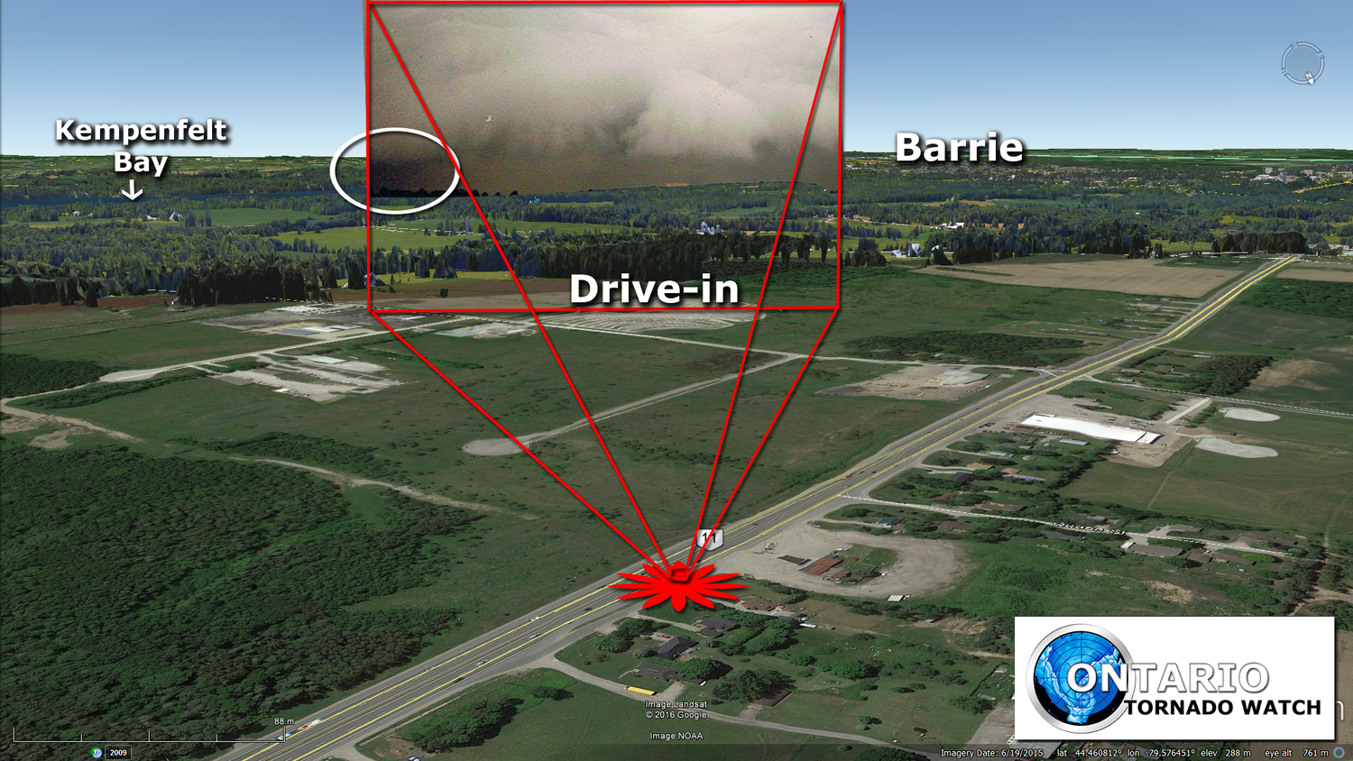
In 2016, Gary Crawford was kind enough to donate the original and only known photo of the Barrie F4 tornado to us for further investigation. Thank you, Gary!

Below is Gary’s photo. He took this photo on Hwy 11, right beside the Drive In Theatre in Guthrie (on the edge of Oro Station). We scanned it at the highest possible resolution and this is originally a 65mb image but compressed to be displayed on our website:

Below is a bit of photo editing we did to simulate what Gary Crawford would have experienced when taking the only known photo of the Barrie F4 tornado producing storm. Comparing the photo and damage path, it seems possible that the dark feature on the bottom left would have been the rain-wrapped F4 tornado. Thankfully, the three Drive-in Movie Theatre screens + the tree line provided the perfect reference points to line up the photo to Google Earth street view. Great job on the incredible photo, Gary!

Below, we compared the photo even further to Google Earth to determine exactly where the photo was taken and which way it was facing. Gary confirmed our estimation of where he was located when taking the photo:
Below, the birds eye view comparison actually reveals a direct correlation between our estimated track (based on multiple, detailed reports) and the camera angle. This helps demonstrate the possibility that the left edge of Gary's photo is actually the rain-wrapped tornado:

Below is an incredible image shared to us by Shirley C. from Hwy 400 in Barrie:

Below is the official Barrie Tornado Track overview that we added to Google Earth, looking east towards Barrie’s Kempenfelt Bay:

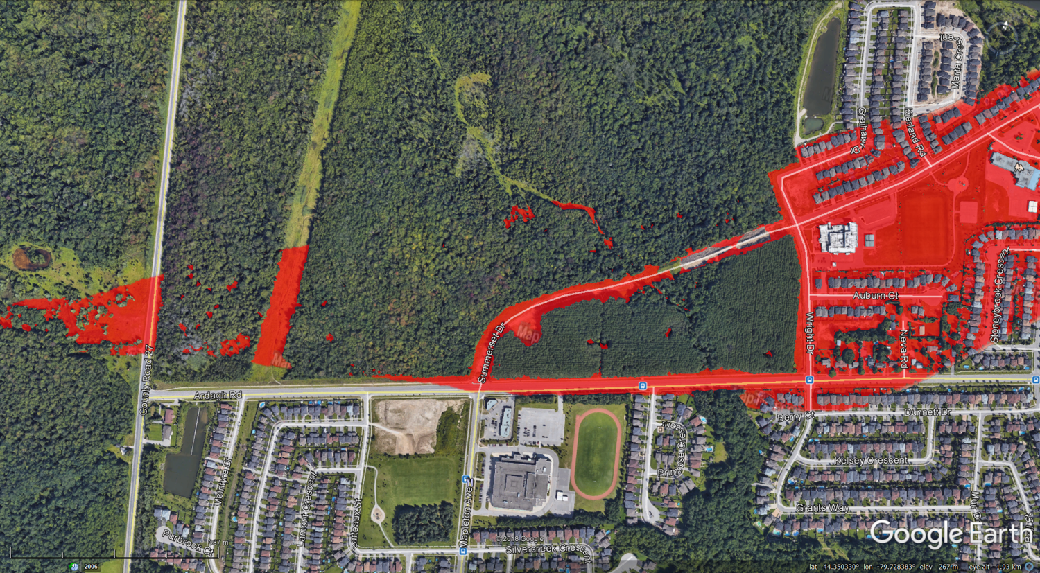
Below are the revised (and as accurate as possible) images showing the official tornado track. We spent a lot of time making sure this was bang on as our older images were a bit too far south on review.
As the tornado first enters Barrie in the Ardagh area, it grew to its peak width of 500m wide:

As the tornado moves past Ferndale drive, the path narrows to 300m wide:


As the tornado crosses Hwy 400 and hits the racetrack, it narrows again to 290m wide:


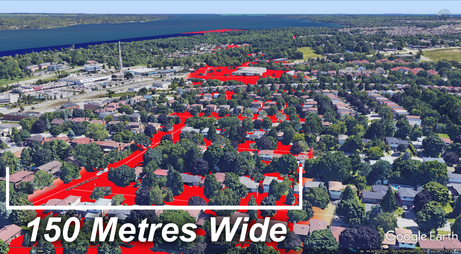
Moving towards Minet's Point, the tornado narrows one last time to 150m wide:

Finally, the tornado grows almost to its original maximum width of 480m as it demolishes the Marina and eventually moves out over Lake Simcoe. It was reported that 30 boats were ripped from their concrete moorings and thrown into Lake Simcoe, never to be recovered:


Our most heartfelt condolences go out to the families and friends of those who were tragically killed. And our thoughts remain with all those who were affected by the violent tornadoes and significant storms on that fateful day.
- Adam & the OTW / IWO team
P.S. The link below is a photo album we've put together of damage photos from May 31st, 1985. Please let us know if we've overlooked anything. Thank you:
https://www.facebook.com/media/set/?set=a.449268851830951.1073741829.444593798965123&type=3
