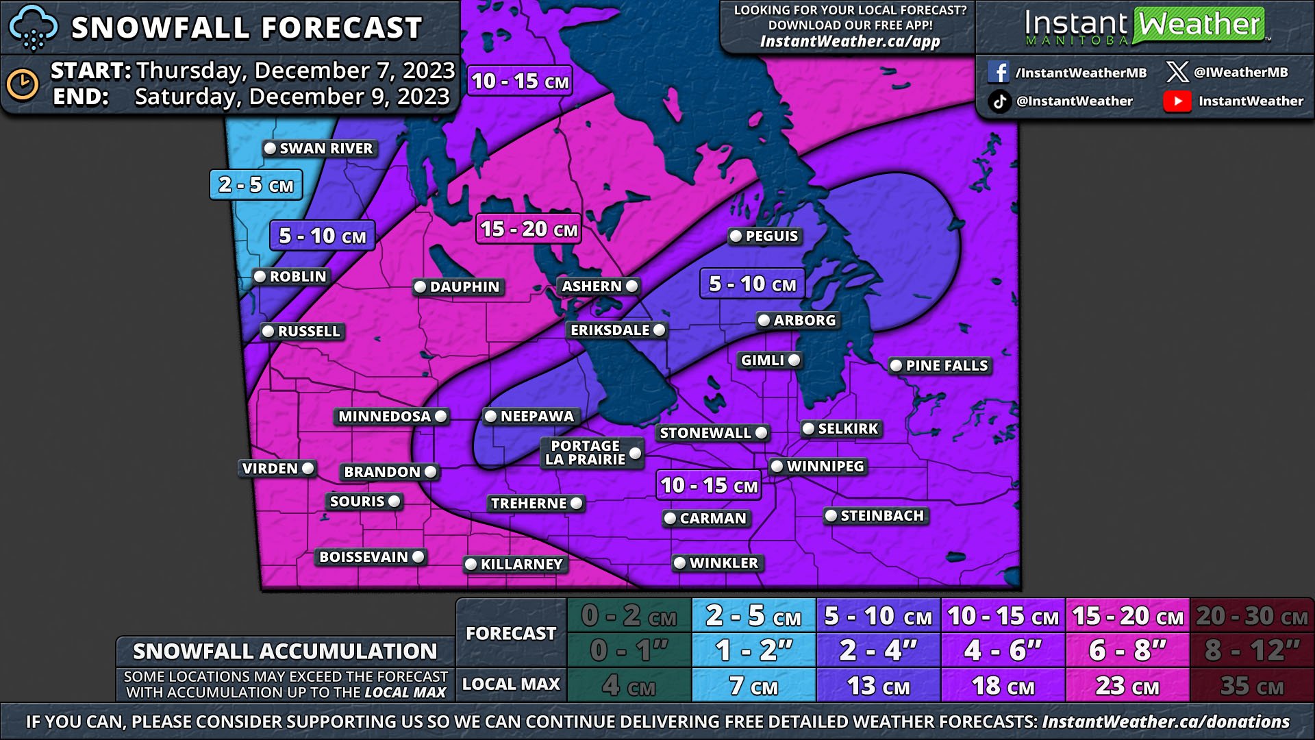
Clouds Could Spoil the Eclipse on Monday for Many in Southern Manitoba, but Clearer to the North

NOTE: YOU CAN CLICK ON THE MAP TO OPEN A ZOOMABLE IMAGE


We’re now in the last few days before the partial solar eclipse that will cross the skies above Manitoba on Monday and we’re now getting a clearer idea of the weather conditions that we can expect for that time period.


GOOGLE AD (NOT ENDORSED BY INSTANT WEATHER)

Safety Measures

In order to safely enjoy the eclipse, it's crucial to use ISO 12312-2 certified solar glasses. Directly looking the sun, even during an eclipse, can cause serious, and possibly permanent, damage to your eyes. You can only view the eclipse without the glasses during the few minutes of totality. Solar glasses are designed to block harmful solar radiation and protect your eyes while allowing you to safely witness the event.

Never use makeshift viewing solutions like sunglasses or homemade filters, as they do not offer adequate protection against the sun's rays. Also, remember that the same rules apply to taking pictures with your phone. The sun can damage your camera’s sensors if you don’t have the proper solar filter (such as the same solar glasses for your eyes).


Your Guide to the Eclipse:


The forecast for Monday looks less than ideal for those who might want to catch a glimpse of the eclipse, with cloud cover expected across a large area of Southern Manitoba in the afternoon. Following a clear, sunny day on Saturday, clouds start to build in from the south early Sunday afternoon. These clouds will spread northward overnight and through Monday morning, leading to a significant area under overcast or partly overcast skies by the time the eclipse begins.

Conditions in Central and Northern Manitoba are looking much more promising at this point, with clear or mostly clear skies expected to persist through Monday afternoon and the duration of the eclipse.

Parts of Saskatchewan and Manitoba to Receive 10–20cm of Snow as Colorado Low Moves In on Wednesday

NOTE: YOU CAN CLICK ON THE MAP TO OPEN A ZOOMABLE IMAGE


A Colorado Low is on course to impact Southern Saskatchewan and Manitoba as the week draws to a close, promising significant snowfall and challenging weather conditions across the regions.

The journey of the Colorado Low northwards brings the first round of snow to Saskatchewan from the south, beginning overnight Tuesday and carrying on into Wednesday morning. The main band of snow is expected to catch up by late Wednesday morning. Along the American border in the southeast of the province, there may be a bit of mixing due to slightly warmer temperatures. 


GOOGLE AD (NOT ENDORSED BY INSTANT WEATHER)

The snow is set to continue unabated through Thursday, beginning to dissipate from west to east Thursday afternoon and concluding entirely by the end of the day. The heaviest snowfall is anticipated in the Southwest and West Central regions, where a broad swath could see accumulations of 10-20cm. This 10-20cm zone also extends into Southeast Saskatchewan, covering a significant portion of the province with a hefty blanket of snow.

The influence of the Colorado Low extends into Manitoba by Wednesday evening, with snow initiating in the southwest and gradually expanding northward throughout the night. By Thursday morning, the snow could intensify, particularly in the Parkland and Westman Regions, where it may fall heavily at times. The storm is expected to exit the region late Friday evening. 


GOOGLE AD (NOT ENDORSED BY INSTANT WEATHER)

A widespread accumulation of 10-20cm is forecasted across Southern Manitoba. However, in the Red River Valley and the Eastman Region, snowfall totals are predicted to be less than 10cm. This is due to mixing with rain as temperatures hover just above the freezing mark, limiting the accumulation of snow in these areas.

Alberta Clipper Could Dump Up to 20cm of Snow on Parts of Southern Manitoba Over Next Few Days

NOTE: YOU CAN CLICK ON THE MAP TO OPEN A ZOOMABLE IMAGE


The Alberta Clipper that has taken a single day to make its way across Alberta and Saskatchewan Tuesday will cross into Manitoba overnight. It’s expected to slowly pass through Southern Manitoba, and it will bring snow to the region until Thursday morning.  


GOOGLE AD (NOT ENDORSED BY INSTANT WEATHER)

The snow will be heavy at times and a large swath of Southern Manitoba, stretching from the Saskatchewan border and southeast into Winnipeg can expect 10-15cm of snow.

The City of Winnipeg and surrounding area will be on the lower end of that range and residents here can expect closer to 10cm of snow. Meanwhile, to the west and northwest, especially in the higher elevations of the Escarpment, snowfall totals will approach 15cm.

An area that includes Swan River and Dauphin can anticipate even more snow as the Clipper will stall over this region for several hours and eventually leading to upwards of 20cm of accumulation.

Most of the rest of Southern Manitoba can expect 5-10cm before the snow dissipates early Thursday.


GOOGLE AD (NOT ENDORSED BY INSTANT WEATHER)

Alberta Clipper Bringing Up to 20cm of Snow to Southern Manitoba Starting Late Thursday

NOTE: YOU CAN CLICK ON THE MAP TO OPEN A ZOOMABLE IMAGE


An Alberta Clipper has already begun to move into the region, bringing rain and some mixed precipitation along the leading edge. The rain will transition over the snow this evening and overnight as it moves southeastward.

The snow will continue to be steady throughout the day Friday, with the heaviest snow falling over a swath from Virden, through Dauphin and Beren’s River, to the Ontario border during the morning.


GOOGLE AD (NOT ENDORSED BY INSTANT WEATHER)

The area can expect snowfall totals exceeding 15cm and approaching 20cm with the possibility of locally higher amounts.

By the late afternoon and into the evening, the heaviest band of snow will move into the Winnipeg area and Southeast Manitoba where closer to 10cm of snow is expected.

The snow will continue to move southeast overnight and into Saturday and will completely leave the region by early to mid-morning Saturday. Strong wind gusts of up to 70km/h are also expected which will greatly reduce visibility with blowing snow.


GOOGLE AD (NOT ENDORSED BY INSTANT WEATHER)

Alberta Clipper to Bring Heavy Snow and Freezing Rain Risk Across Saskatchewan and Manitoba on Sunday

NOTE: YOU CAN CLICK ON THE MAP TO OPEN A ZOOMABLE IMAGE


A low-pressure system from Alberta has already begun making its way into Saskatchewan and towards Manitoba. Overnight tonight, snow and freezing rain will develop in Eastern Saskatchewan, and it will continue until late Sunday morning as the system continues to push eastwards.

In Manitoba, the precipitation will begin later, starting in the morning on Sunday and it is expected to continue throughout most of the day. Less than 5mm of ice accretion is expected, but a large part of Western Manitoba will be affected.


NOTE: YOU CAN CLICK ON THE MAP TO OPEN A ZOOMABLE IMAGE

Snowfall amounts will be more widespread in Manitoba than in Saskatchewan with considerably higher totals. In particular, the Interlake Region and east of Lake Winnipeg could see over 10cm of snow by the end of the day Sunday.


GOOGLE AD (NOT ENDORSED BY INSTANT WEATHER)

NOTE: YOU CAN CLICK ON THE MAP TO OPEN A ZOOMABLE IMAGE


Similar to Manitoba, total ice accretion in Saskatchewan will be less than 5mm, however, this will be enough to make surfaces slippery if left untreated and there is the potential for broken tree branches.


NOTE: YOU CAN CLICK ON THE MAP TO OPEN A ZOOMABLE IMAGE

Snowfall amounts in Saskatchewan will mostly remain less than 5cm except for an area around Hudson Bay, where up to 10cm could fall. The freezing rain will fall further south of the snow and some areas may see a mix of both snow and freezing rain.


GOOGLE AD (NOT ENDORSED BY INSTANT WEATHER)

More Snow Expected for Southern Manitoba on Thursday and Friday

NOTE: YOU CAN CLICK ON THE MAP TO OPEN A ZOOMABLE IMAGE


As the snow continues in Southern Manitoba, we’re looking ahead to tomorrow afternoon when a second round moves into the region.

The light snow will persist through the overnight hours, bringing a few more centimetres, before ending in the mid-morning. After a few hours, the snow will begin again, moving in from the south in the evening and continuing through to Friday afternoon.


GOOGLE AD (NOT ENDORSED BY INSTANT WEATHER)

The greatest snowfall will be in the Southeast and with snowfall rates unlikely to exceed 2cm/hr, a maximum of 10cm can be expected, however local amounts could approach 15cm.

Temperatures will be hovering around the freezing mark so it is likely that there will be some rain mixed in with the snow, which could limit overall accumulation.


GOOGLE AD (NOT ENDORSED BY INSTANT WEATHER)

Say It Ain’t Snow! First Major Snowfall of the Season Takes Aim at the Prairies

NOTE: YOU CAN CLICK ON THE MAP TO OPEN A ZOOMABLE IMAGE


After a warm start to fall across much of the Prairies, conditions have begun to turn, with dropping temperatures dropping heralding the first significant snowfall of the season. 

The snow has already begun for Southern Alberta and into Southern Saskatchewan where it will continue overnight and throughout the day Tuesday. The heaviest snow, with totals of 10-20cm, is expected in the Rockies and eastward through Calgary and Lloydminster.


GOOGLE AD (NOT ENDORSED BY INSTANT WEATHER)

A secondary pocket of heavy snowfall is also possible in Southwestern Saskatchewan. Surrounding areas and Southern Manitoba can expect 5-10cm of snow by the end of the day Wednesday.

Following the snow, Arctic air will begin to settle into the region with overnight low temperatures in the negative double digits across much of Southern Alberta and Saskatchewan Tuesday into Wednesday and again the following night.


GOOGLE AD (NOT ENDORSED BY INSTANT WEATHER)