Massive Upgrade to Environment Canada's Warning System Coming as Early as Tuesday
/
For as long as Canadians have received Tornado Warnings on their phones, those warnings have been shaped by lines that have nothing to do with weather.
Municipal boundaries. County lines. Forecast regions drawn decades ago for the convenience of the people issuing the alert, not the people receiving it. When a supercell crossed into one of those zones, everyone inside got the same alert: the family directly under the storm and the family 60 kilometres away on the other side of the region, watching a sunset.
That is about to end.
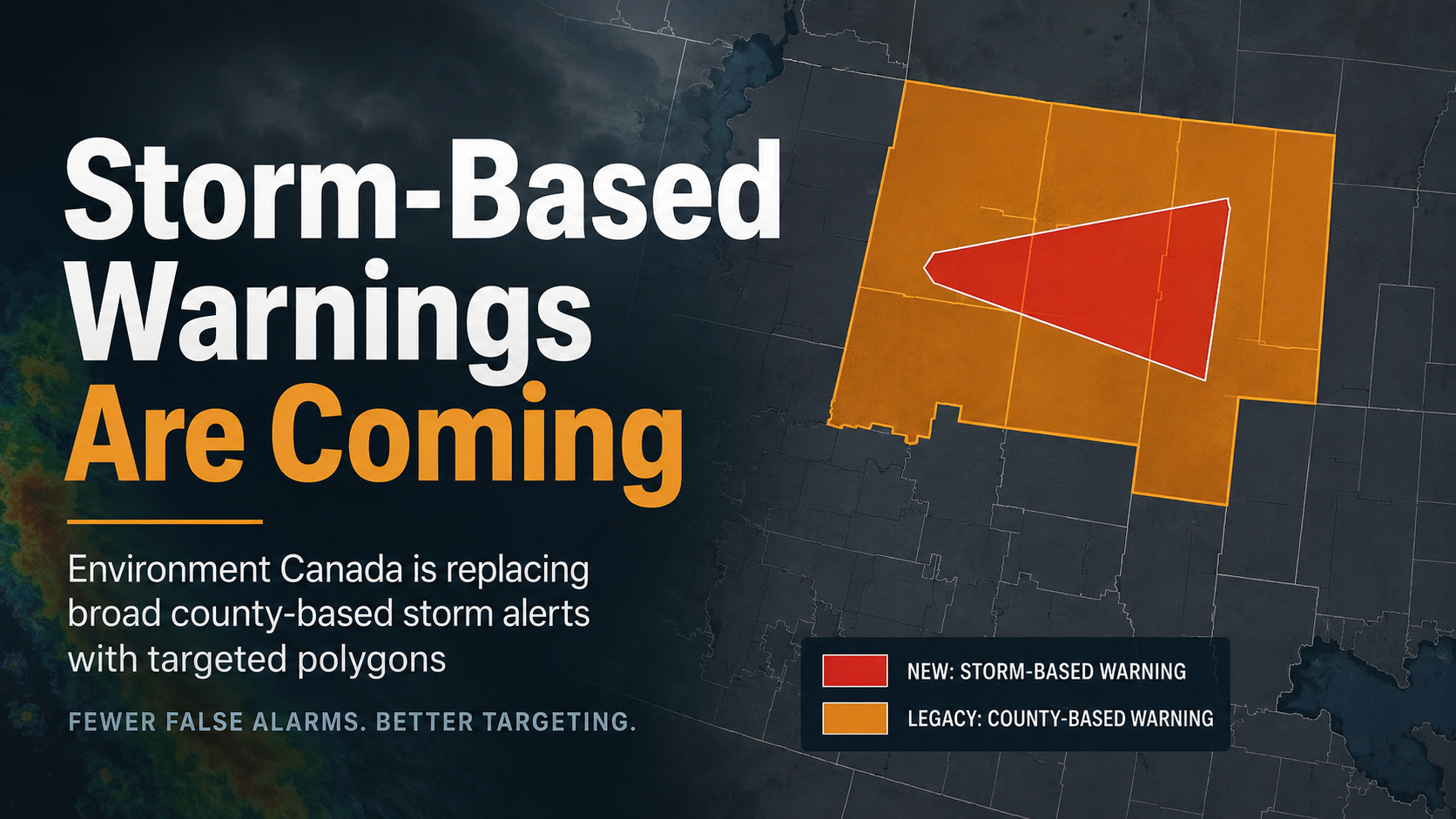
Environment Canada is finally replacing the giant zone-based Tornado Warnings and Severe Thunderstorm Warnings with much more focused storm-based warnings, which forecasters will hand-draw based on the storm's location and direction. We say 'finally' because the US implemented storm-based warnings 19 years ago on October 1st, 2007. Here at Instant Weather, we've sent custom notifications for dangerous storms using hand-drawn polygons for the past 10 years. Additionally, Environment Canada has been attempting to launch the new system for two years but downstream setbacks have forced several delays. Nonetheless, it’s better late than never and we certainly appreciate how important it is to get a change like this right when lives depend on it.
The new system, called CAM or Convective Alert Modernization is planned to launch on Tuesday, August 11th, 2026. However, the Environment Canada team responsible for launching it told Instant Weather in an email that the launch is largely weather dependent and the 12th and 13th are backup dates. Additionally, there's a small chance unforeseen technical setbacks could delay it even further but from what we're hearing, it's looking very promising that the new system will launch sometime between Tuesday and Thursday.
HOW ABOUT TV AND RADIO ALERTS?
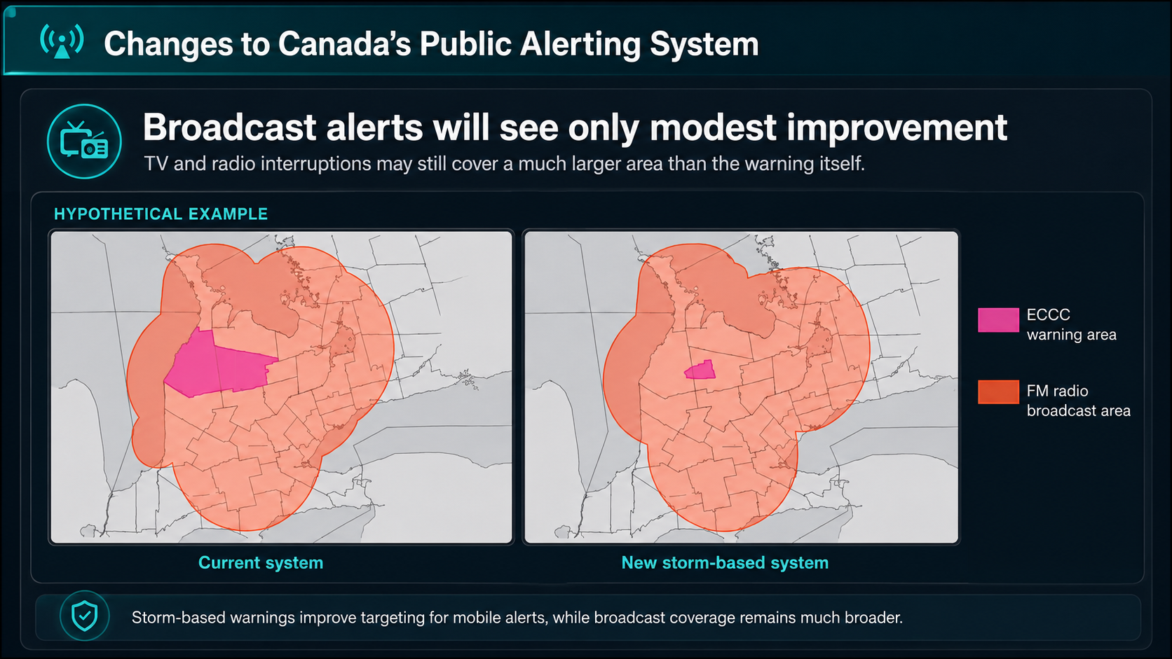
HYPOTHETICAL EXAMPLE OF HOW STORM BASED ALERTS WILL ONLY SHOW MARGINAL IMPROVEMENTS FOR TV AND RADIO ALERTING
The amazing news: this change is expected to reduce the number of cell phones automatically receiving Tornado Warnings and red-level Severe Thunderstorm Warnings by roughly 70%, with the greatest improvements seen by those in rural communities where legacy alert zones are massive.
The not-so-good news: Radio and T.V. alerts will only see very marginal improvements. This is still a major issue as broadcast alerts can notify people more than 100 km away from the path of the storm in some circumstances.
Long story short, if you do receive a Tornado Warning or red-level Severe Thunderstorm Warning on your T.V. or Radio but not on your phone, take the warning seriously and make sure to check the storm-based polygon to determine whether your location is in the storm’s warned path. You can check using our free app Instant Weather or Environment Canada's website, for example to quickly determine this.
This is the most consequential change to Canadian storm alerts in a generation, and it did not arrive a moment too soon.
THE TIME FOR CHANGE IS NOW
The case for storm-based warnings has been building for decades and this above-average tornado season made it hard to ignore.
Canada is on pace for an above-average tornado year. By August 7th, 87 tornadoes had been confirmed nationally, more than 70 of them across Alberta, Saskatchewan and Manitoba. Manitoba alone had logged 10 by mid-July, against a 30-year average of 8.5 for an entire season, according to the Northern Tornadoes Project.
But warnings have been outpacing the tornadoes, and this mismatch has been frustrating some Canadians.
In June, phones across southern Manitoba lit up repeatedly during a single evening of storms. Some Winnipeg residents reported receiving upwards of 20 alerts. Two tornadoes did touch down that night, 30 to 50 kilometres south of the city. For people in Winnipeg, the threat was never close. Environment Canada later confirmed it was investigating why some recipients received the same alert multiple times.
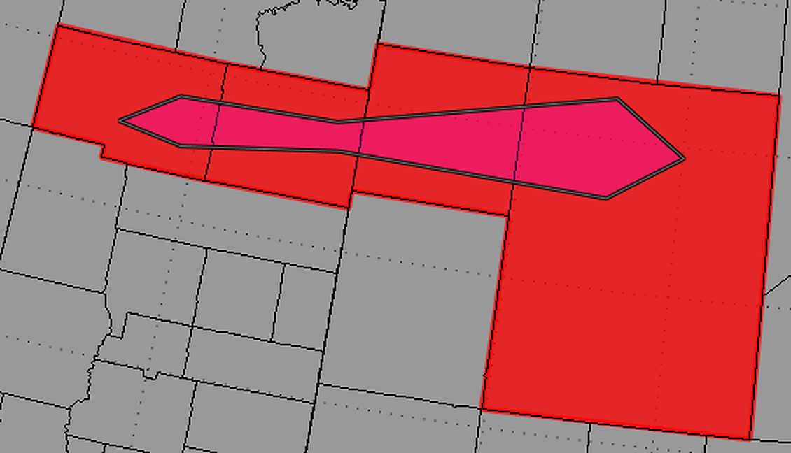
WHAT ACTUALLY IS A POLYGON?
It's actually simpler than the name suggests.
Instead of selecting large zone-based regions when issuing a warning, an Environment Canada forecaster will now draw a small shape directly on a map: a box enclosing where the storm is now and where it is going. Forecasters then use that shape to target the alert, which is pushed to cell towers.
Something important to consider: these new hand-drawn warnings will continue to notify phones outside the actual alert region if their phone is reachable by the cell phone towers inside the alert. However, since alert regions will be 75% smaller, the number of people alerted inside and outside of the alert will decrease significantly. There can also be a benefit to some people just outside the polygon being notified, particularly if they are travelling toward the warned area.
Importantly, Environment Canada is applying this only to Severe Thunderstorm Warnings and Tornado Warnings. Every other alert type, including winter storm warnings, rainfall warnings, heat warnings, snow squall warnings, air quality statements, etc., continues to be issued using the legacy, zone-based areas. This is a surgical change to the two alert types where minutes and kilometres matter most.
ARE LEGACY ALERT ZONES STILL ACTIVE?
For broadcasters, app developers, emergency managers and anyone else consuming Environment Canada's alert feed, this is the section that matters. The technical documentation Environment Canada has released is unusually specific, and its design decisions are worth understanding.
The zone blocks are not going away. This is the single most important compatibility fact. The new free-form polygon arrives as an additional product within the alert message. The existing, large county-based and municipality-based zone alerts continue to exist exactly as they do today, so systems not ready for storm-based warnings will keep working. It is an addition, not a replacement.
Based on Environment Canada’s documentation, two versions of the same Tornado Warnings and Severe Thunderstorm Warnings will be issued simultaneously. One will be issued for the legacy zone-based regions to support those slow to adopt to the new system and as a fallback, and an additional, more accurate storm-based warning will also be issued.
Thankfully, and this part is huge: AlertReady, the system that pushes Amber Alerts, Tornado Warnings, etc., directly to your cell phone will use the drastically smaller storm-based warning, not the legacy zone-based warnings. Only in the case of a storm-based warning failure will the legacy system be used.
WHAT POLYGONS WILL NOT FIX
Precision within a Tornado Warning region is not the same as precision in tornado detection, and it is worth clarifying that gap.
Environment Canada's upgraded S-Band radars are a significant improvement over the replaced C-Band radars. However, due to technical choices made by Environment Canada, detecting small areas of rotation in high-shear environments is a huge problem because of noisy velocity (wind) data.
The math behind false alarms is also unforgiving. According to historical data, like that produced by the Northern Tornadoes Project, less than 10% of severe thunderstorms produce a tornado. Forecasters will continue to warn on storms that never produce, because the alternative, waiting for confirmation, costs lives. What polygons change is who receives those false alarms. Under the old system, an entire region dealt with every false alarm. Under the new one, only the people genuinely downstream do. That is how a warning system rebuilds credibility: not necessarily by eliminating false alarms, but by exposing far fewer unaffected people to them.
And a smaller warning area carries its own risk. A tighter polygon means more people just outside the line, people who, under the old system, would have been warned. Storms deviate. Tornadoes form on the flank. No alert on your phone is not the same as no threat near you, and it never has been.
WHAT TO DO ABOUT IT
Keep watching the sky and the radar, not just your notifications. Targeted alerting works when it is paired with situational awareness, not when it replaces it.
Get alerts from at least two trusted sources, as no system is perfect.
And when your phone does go off, take it seriously. Starting next week, the Tornado Warning or red-level Severe Thunderstorm Warning that reaches you via AlertReady is far more likely to affect your community than in previous years.
Welcome to the future of severe weather alerting, Canada.