Rapid Intensification of Helene to a Major Hurricane Expected in the Gulf as it Approaches Florida
/
Satellite Image of Hurricane Helene from September 25th at 11:26Am EDT, Courtesy of Colorado State University.
Tropical Storm Helene became a Category 1 Hurricane this morning as it continues to track offshore of the Yucatan Peninsula with maximum flight-level wind gusts measured at 81 knots (93mph or 150km/h) by recon flights. Based on this data, it is estimated that the maximum surface winds are 70 knots (81mph or 130 km/h). This is only the beginning of the strengthening of this storm as it is expected to rapidly intensify over the next 24 hours into a major Category 3 Hurricane as it bears down on the Florida Panhandle and Big Bend Coast.
The latest forecast track from the National Hurricane Center (NHC) shows that Helene is expected to turn northward and then north-northeastward later today and it will maintain that track as it makes landfall in Florida as a Major Hurricane.
At this point, it is still a bit too early to predict the exact location that Helene will make landfall along the Florida coast, but given the sheer size of the storm, the impacts will be widespread across the state. The storm has a massive wind field and tropical storm-force winds are already pushing their way into the Keys. These strong winds will gradually make their presence known further northward throughout the evening and overnight tonight, reaching the Panhandle tomorrow morning. Winds will increase in strength as the storm makes its final approach, with devastating hurricane-force wind gusts up to 125mph (200 km/h) projected for areas closest to where the storm will make landfall.
Inundating rainfall causing widespread flooding is also a major concern with Hurricane Helene across Florida with over 5 inches (127mm) of rain expected along the coast and lesser amounts of under 2 inches (51mm) further inland. Rainfall totals could easily exceed 10 inches (254mm) throughout the Panhandle.
Along with intense winds and flooding rainfall, life-threatening storm surge is expected along the entire Gulf Coast of Florida and the Big Bend Coast could see water levels exceeding 10ft. These factors all combined have prompted widespread Hurricane and Tropical Storm Warnings, evacuations, and States of Emergencies in almost every county in the state.
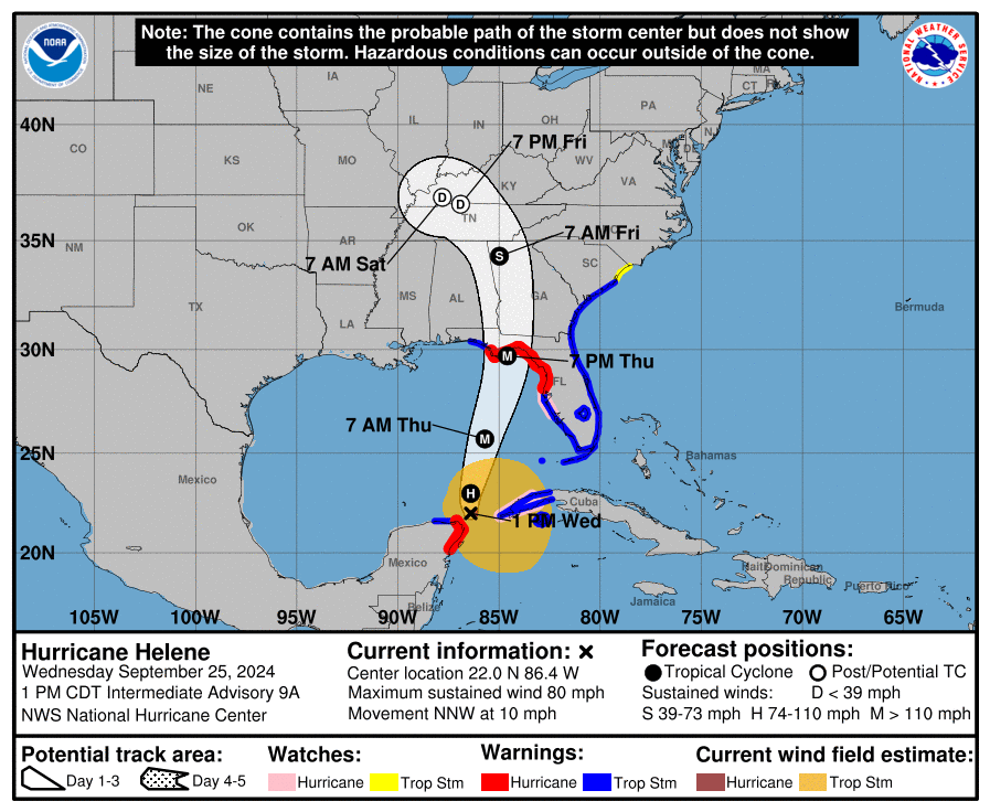
Forecast Track for Hurricane Helene, Courtesy of The National Hurricane Center.
Beyond landfall, the storm is expected to pack quite a punch through the rest of the Southeast and into the Ohio Valley with intense winds and heavy rainfall.
The destructive wind gusts will push their way well inland into Southern Georgia and even as far north as the Southern Appalachians. These strong winds will easily bring down trees and power lines, resulting in widespread power outages, as well as damage to property.
The Blue Ridge Mountain and Piedmont Regions of Northern Georgia and the Western Carolinas are also possibly looking at receiving up 12 inches (305mm) of rain by the end of the weekend as the storm is expected to stall beginning late Friday. This much rain will bring the risk of flooding and landslides across the region.
Helene will remain in an ideal environment over the next 24 hours with sea surface temperatures above 30°C, relatively low shear, and strong upper-level divergence, all key for rapid intensification of a tropical storm/hurricane. There is a bit of uncertainty of exactly how strong Hurricane Helene will become, with some weather models suggesting it could reach Category 4 strength, however, it is increasingly likely that it will make landfall as a Category 3 Hurricane.
It is not too late to take necessary precautions to protect life and property ahead of this storm. If you or your loved ones are in the path of the storm, please heed all directives from emergency personnel and stay safe!
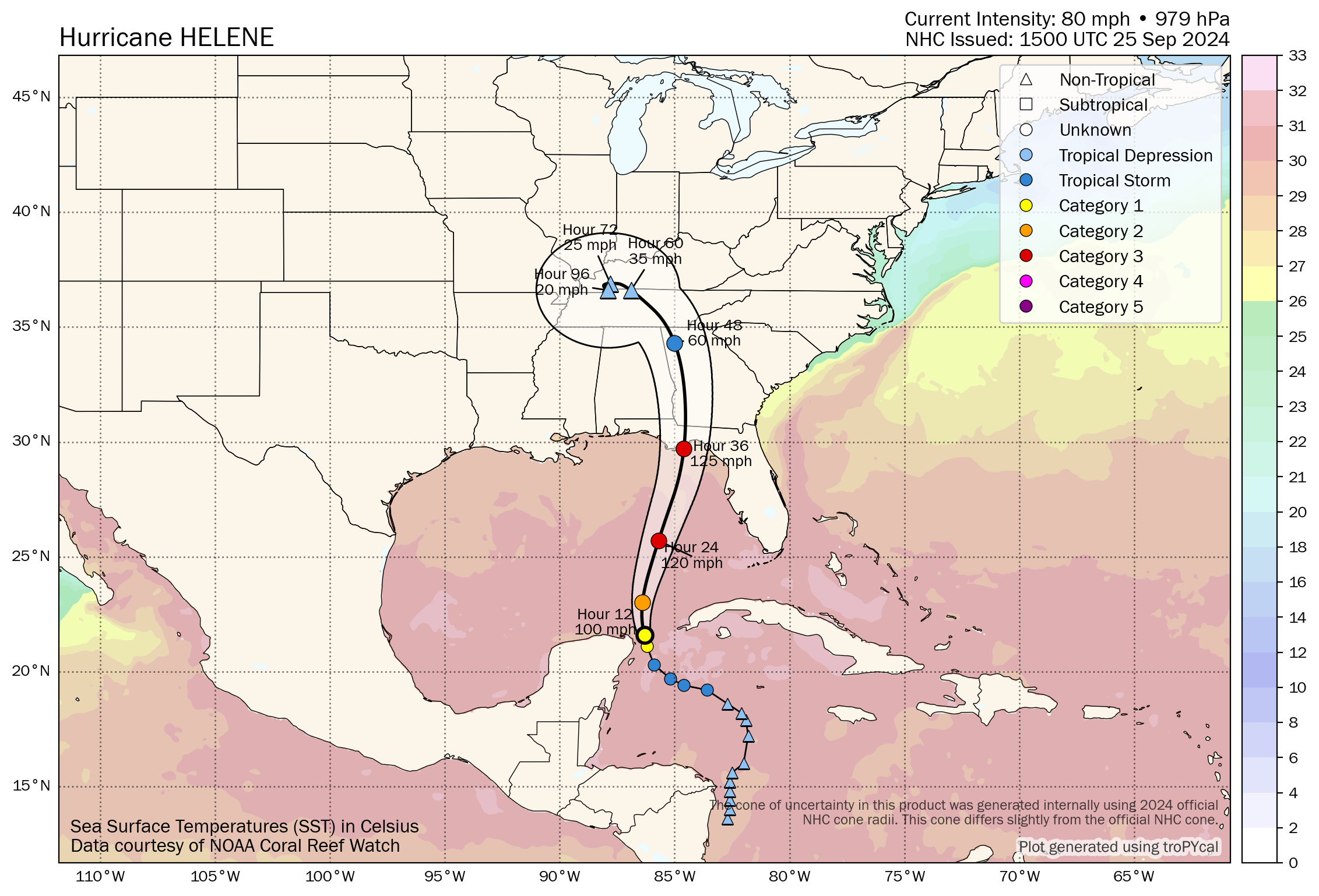
Forecast Track and Intensity of Hurricane helene with Sea Surface Temperatures, courtesy of Tomer Burg.