Storm of the Century for Tampa and Central Florida; Catastrophic Hurricane Milton Will Make Landfall Tonight

Satellite Image of Hurricane Milton from October 8th at 10:30PM EDT, Courtesy of Colorado State University.

Hurricane Milton managed to maintain its status as a Category 5 hurricane overnight and has since been downgraded to a still catastrophic Category 4. Milton has finally started to encounter some shear that began to change its structure and will cause the storm to weaken. The shear is expected to increase throughout the day, weakening the storm further, but it is still expected to be a powerful Category 3 hurricane upon landfall later tonight. Current projections have landfall occurring at around 1am with maximum sustained winds of 125 mph (201 km/h).

There have also been continued southward wobbles in Milton's track and this has pushed the potential landfall location further south. The margin of error is approximately 20 miles at this point, so the exact location of landfall is starting to become a bit clearer. Regardless of where the storm eventually makes landfall, the shear will cause the storm to grow and the devastating impacts will be widespread. This is the first hurricane to directly impact the Tampa area since 1921, making Hurricane Milton the storm of the century for the region.


GOOGLE AD (NOT ENDORSED BY INSTANT WEATHER)

Reflectivity from the Tampa Bay Radar Station on October 9th at 11:40AM EDT.

The eye of the hurricane is now visible on both Key West and Tampa Bay radars and we've already begun to see significant rainfall moving inland in Central Florida. Current rainfall totals for the Tampa area are in the 1-2 inch (25-50mm) range, but with the heaviest bands of rain just starting to come ashore, these numbers will jump.

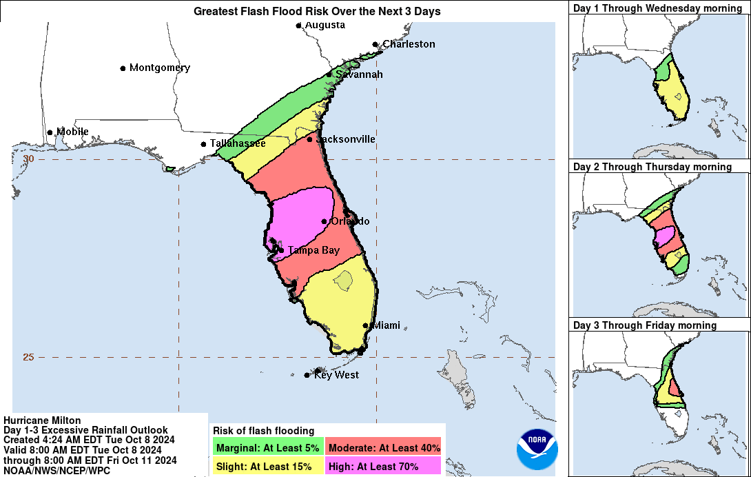
Widespread flooding remains a major concern across central and northern portions of the Florida Peninsula, with localized rainfall totals potentially reaching 18 inches (457 mm). These heavy rains will push far inland and elevate the risk of flash flooding over a large part of the state, especially in low-lying areas and along rivers. The Weather Prediction Center (WPC) continues to forecast a High Risk (their highest level) for flash flooding across a large swath of Central Florida that includes Tampa and Orlando.

We've also seen several tornado warnings and confirmed tornadoes south of Lake Okeechobee. Tornadoes are a major threat when hurricanes approach shore from the many imbedded thunderstorms and the potential for more tornadoes will continue into the afternoon and expanding northward with the overall motion of the hurricane.


GOOGLE AD (NOT ENDORSED BY INSTANT WEATHER)

Tropical storm-force winds are started to make their way over land with the rain this morning and they will gradually spread further inland throughout the day as the storm makes its final approach and the increased shear causes the wind field to grow. The area of hurricane-force winds will also become larger, but since they are found closer to the eye, they won’t be felt inland until closer to landfall.

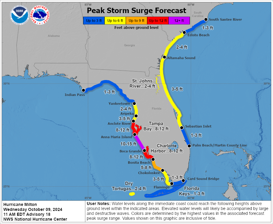
The continued southern shift that's been seen in Hurricane Milton's track has also shifted where the greatest storm surge is expected. The greatest peak storm surge of 10-15ft is now forecasted along the coast from Anna Maria Island to Boca Grande. The forecast for Tampa Bay has been downgraded to 8-12ft, but this is still a life-threatening amount of water.

With a little over 12 hours until landfall, there is very little time left for those in the path to make their final preparations. If you or your loved ones are in the storm’s potential path, it’s crucial to stay informed, heed evacuation orders if they are issued, and follow any directives from local emergency personnel. We will continue to provide updates throughout the day as Milton makes its final approach.


Peak Storm Surge Forecast in FLorida for Hurricane Milton, Courtesy of The National Hurricane Center.

Florida Braces for Catastrophic Landfall of Hurricane Milton; Potential to be the Most Destructive Hurricane on Record for the State

Satellite Image of Hurricane Milton from October 8th at 2:21PM EDT, Courtesy of National Hurricane Center.

Following its almost unprecedented intensification from a Tropical Storm to a Category 5 hurricane and becoming the 5th most intense Atlantic hurricane on record, Milton’s development was stunted overnight while undergoing an eyewall replacement cycle. During this, the inner structure of the storm changed significant, with the eye filling in and the wind field expanding. The peak winds fluctuated and Milton was downgraded to a Category 4 hurricane this morning.

With the eyewall replacement complete, the eye cleared and shrunk in size, marking the possibility it might regain some of its slight loss in strength and achieve Category 5 status once again. The latest Hurricane Hunter recon mission estimates that Milton is just shy of the threshold of becoming a Category 5 hurricane with maximum sustained winds of 155 mph (250 km/h). However, continued structural changes over the next 24 hours will result in further fluctuations in strength.


GOOGLE AD (NOT ENDORSED BY INSTANT WEATHER)

Forecast Track for Hurricane Milton, Courtesy of The National Hurricane Center.

Hurricane Milton continues its offshore passage of the Yucatan Peninsula, where it has brought significant damage to coastal areas. The storm has already made its predicted turn and begun moving northeastward into the heart of the Gulf, where it will increase its forward speed bringing it into Central Florida.

There has been very little change in the official forecast track from the National Hurricane Center (NHC), aside from the possibility that landfall might occur just south of Tampa Bay. This slight change is of little consequence because even at 24-36 hours out, the NHC forecasts have of a margin of error 60-70 miles so it is still difficult to pinpoint exactly where landfall will occur. Furthermore, Milton and its wind field are still projected to grow in size as the storm encounters vertical wind shear ahead of landfall. The area of hurricane and tropical storm-force winds is expected to double in size, spreading the threats of life-threatening surge, heavy rains, and destructive winds far beyond the forecast cone.

The NHC’s storm surge forecast for the Anclote River to Englewood, including Tampa Bay, has been increased to 10-15ft and could be double that from Hurricane Helene two weeks ago. With the area still recovering from storm surge damage that resulted from Helene, large piles of debris can be found all along the coast, posing a very unique threat. Not only will some of the debris get washed back inland with the storm surge, the hurricane-force winds could easily turn these remnants into dangerous projectiles when the storm hits.


GOOGLE AD (NOT ENDORSED BY INSTANT WEATHER)

In addition to the threat of storm surge and intense winds, central and northern portions of Florida Peninsula could see 5-12 inches (127-305 mm) of rainfall, with localized totals potentially reaching 18 inches (457 mm). These heavy rains will push far inland and elevate the risk of flash flooding over a large part of the state, especially in low-lying areas and along rivers. The Weather Prediction Center (WPC) has issued a High Risk (their highest level) for flash flooding across a large swath of Central Florida that includes Tampa and Orlando.

After landfall, Milton is expected to track across the Florida Peninsula and emerge into the Atlantic, where it will briefly remain a hurricane before transitioning into a post-tropical storm. However, the impacts to Florida and surrounding areas will be significant long before the storm weakens.


Flash Flood Forecast in Florida from Hurricane Milton, Courtesy of The National Hurricane Center.

Milton’s rapid intensification has been fuelled by its movement through an area of deep, warm waters, with sea surface temperatures exceeding 28°C, providing ample energy for the storm. Additionally, low wind shear in the region has allowed the hurricane to strengthen unhindered. Thankfully, we began to see that development stall overnight with the eyewall replacement cycle. As it continues to approach Florida, Milton is still expected to encounter an area of shear that will weaken it further, but it will still be a powerful hurricane at landfall. The NHC forecast maintains that it could make landfall as a Category 3 hurricane, with maximum sustained winds of 125 mph (201 km/h). However, they have stated that this projection is on the high end of model guidances so there is the possibility of an adjustment to this forecast in the next 24 hours.


GOOGLE AD (NOT ENDORSED BY INSTANT WEATHER)

The entire Florida Peninsula is now under a Tropical Storm or Hurricane Warning. Residents in the projected path are being urged to finalize their preparations while there is still time. Tropical storm-force winds are expected to arrive as early as tomorrow morning, with landfall projected overnight Wednesday. While uncertainty remains regarding Milton’s exact landfall location and strength, the potential for widespread heavy rainfall, destructive winds, and life-threatening storm surges is significant.

If you or your loved ones are in the storm’s potential path, it’s crucial to stay informed, heed evacuation orders if they are issued, and follow any directives from local emergency personnel. We will continue to provide updates as more information becomes available, so stay tuned. Your safety is the priority as Hurricane Milton approaches.


Forecast Track and Intensity of Hurricane Milton with Sea Surface Temperatures, courtesy of Tomer Burg.

Milton Rapidly Intensifies into Dangerous Category 5 Hurricane; Threatens to Slam into Tampa Bay, Florida on Wednesday

Satellite Image of Hurricane Milton from October 7th at 11:59am EDT, Courtesy of Colorado state university.

In a remarkable and alarming turn of events, Hurricane Milton has rapidly intensified from a Category 1 to a Category 5 hurricane within just 18 hours, marking one of the most rapid intensifications on record in the Atlantic. Only Hurricane Wilma intensified faster, strengthening in just 12 hours back in 2005. Such an extreme escalation underscores the potential danger of this storm as it continues to grow in strength.

Data gathered by Hurricane Hunter aircraft earlier this morning estimated that Milton’s maximum sustained winds were around 160 mph (257 km/h), making it the second hurricane this season to reach Category 5 intensity, following Hurricane Beryl in July. However, more recent data now indicates that Milton’s winds have increased even further to 175 mph (282 km/h), with a minimum central pressure of 911mb, making it the strongest Atlantic hurricane since Dorian in 2019. These numbers highlight just how powerful Milton has become in such a short span of time.


GOOGLE AD (NOT ENDORSED BY INSTANT WEATHER)

Forecast Track for Hurricane Milton, Courtesy of The National Hurricane Center.

Interestingly, Hurricane Milton did not follow its projected almost directly eastward path overnight. Instead, the storm has wobbled southeastward, bringing it much closer to the Northern Yucatan Peninsula than initially forecasted. As a result, Mexican authorities have issued Hurricane Warnings, anticipating hurricane-force winds to impact the region today. The shift in track has led to a stronger storm approaching the Yucatan, further complicating forecasts and increasing the potential for damage along the coast.

This unexpected change in Milton’s path has also influenced weather models and the official forecast track from the National Hurricane Center (NHC). Despite continued uncertainty regarding Milton’s precise path, the storm is now forecasted to make landfall further south than originally thought, with the Tampa Bay area now directly in its sights. The NHC predicts that Milton will curve northeastward later this afternoon, with an increase in forward speed, leading to a likely landfall on Wednesday evening.

Unfortunately, this is a worst-case scenario for Tampa Bay, as the region is still recovering from storm surge damage caused by Hurricane Helene less than two weeks ago. Now, with Milton’s stronger winds and greater storm surge, the area faces an even more dangerous situation. With plenty of loose debris still scattered along the coast, the hurricane-force winds could easily turn these remnants into dangerous projectiles when the storm hits. The NHC is currently forecasting storm surges of 8-12 feet from the Anclote River to Englewood, including Tampa Bay itself. Due to Milton’s angle of approach, the surge could be more severe than what was seen with Helene, posing an even greater threat to life and property.

In addition to storm surge concerns, much of the Florida Peninsula and the Florida Keys could see 5-10 inches (127-254 mm) of rainfall, with localized totals potentially reaching 15 inches (381 mm). These heavy rains elevate the risk of flash flooding, especially in low-lying areas and along rivers.

After landfall, Milton is expected to track across the Florida Peninsula and emerge into the Atlantic, where it will briefly remain a hurricane before transitioning into a post-tropical storm. However, the impacts to Florida and surrounding areas will be significant long before the storm weakens.


GOOGLE AD (NOT ENDORSED BY INSTANT WEATHER)

Peak Storm Surge Forecast in FLorida for Hurricane Milton, Courtesy of The National Hurricane Center.

Milton’s rapid intensification has been fuelled by its movement through an area of deep, warm waters, with sea surface temperatures exceeding 28°C, providing ample energy for the storm. Additionally, low wind shear in the region has allowed the hurricane to strengthen unhindered. However, as Milton moves further north, it is expected to encounter stronger wind shear, which should start to weaken the storm after about 24 hours as a Category 5 hurricane. Though this shear may reduce Milton’s intensity, it could also cause the storm to expand, spreading its damaging winds and heavy rains over a much larger area. The current NHC forecast suggests that Milton could make landfall as a Category 3 hurricane, with maximum sustained winds of 125 mph (201 km/h).


GOOGLE AD (NOT ENDORSED BY INSTANT WEATHER)

States of Emergency remain in place for much of Florida, with the exception of the Panhandle. Residents in the projected path are being urged to finalize their preparations while there is still time. Tropical storm-force winds are expected to arrive as early as overnight Tuesday and Wednesday morning, with landfall projected for Wednesday evening. While uncertainty remains regarding Milton’s exact landfall location and strength, the potential for widespread heavy rainfall, destructive winds, and life-threatening storm surges is significant.

If you or your loved ones are in the storm’s potential path, it’s crucial to stay informed, heed evacuation orders if they are issued, and follow any directives from local emergency personnel. We will continue to provide updates as more information becomes available, so stay tuned. Your safety is the priority as Hurricane Milton approaches.


Forecast Track and Intensity of Hurricane Milton with Sea Surface Temperatures, courtesy of Tomer Burg.

Florida Braces for Second Major Hurricane Hit in Less Than Two Weeks With Milton; Tampa Area Could See Life-Threatening Storm Surge

Forecast Track for Hurricane Milton, Courtesy of The National Hurricane Center.

After monitoring a disturbance in the Western Caribbean and Gulf of Mexico for over a week, the National Hurricane Center (NHC) confirmed the formation of Tropical Depression 14 in the Western Gulf, which quickly strengthened into Tropical Storm Milton by yesterday afternoon. Since then, Milton has continued to strengthen, with both satellite and aircraft reconnaissance data indicating a sharp increase in intensity. As of the latest update, Milton has been upgraded to a Category 1 hurricane, with maximum sustained winds of 80 mph (129 km/h).

What makes this storm particularly concerning is its projected path, which takes it directly toward the Tampa Bay area. If this forecast holds, Milton will be the first hurricane to make landfall in Tampa since 1996. However, what’s raising even more alarm is the potential for a greater storm surge in the Tampa area than what was seen with Hurricane Helene less than two weeks ago. Milton’s angle of approach is expected to produce a more severe storm surge in the region, which could compound the impact.

While the formation of hurricanes in the Western Gulf of Mexico isn’t particularly common, it’s certainly not unprecedented, especially given the exceptionally warm water temperatures the basin is currently experiencing. These conditions are ripe for storms like Milton to intensify quickly.


GOOGLE AD (NOT ENDORSED BY INSTANT WEATHER)

As of now, Hurricane Milton is forecasted to track almost due east today and tomorrow before turning northeast late on Monday. It will remain offshore of the Yucatan Peninsula, but close enough to prompt Tropical Storm Watches and Warnings in the region. The storm is expected to pick up speed on Tuesday and Wednesday, continuing along its northeastward track, as it heads toward Florida, with landfall anticipated late Wednesday morning or early afternoon.

There’s still significant uncertainty about the storm’s exact path, especially where it will ultimately make landfall in Florida. Current model forecasts, along with the official NHC projection, suggest that Milton will make landfall north of Tampa, near the Crystal River area. If this track holds, it may spare Tampa from the worst of Milton’s winds, but the region will still face heavy rainfall and significant storm surge. Early estimates suggest up to 6 inches (152 mm) of rain and a storm surge that could reach as high as 10 feet in Tampa Bay.

It’s important to note that track forecasts this far out still have a margin of error of around 100 miles, so these projections could change over the coming days. As more data comes in, the forecast will likely be refined.

Following making landfall, Milton is expect to cross the Florida Peninsula and into the Atlantic Ocean, where it will continue briefly as a hurricane before transitioning into a post-tropical storm.


Model Forecast Tracks for hurricane Milton, Courtesy of Tomer Burg.

Milton is currently moving through an area of warm, deep waters, with sea surface temperatures above 28°C, which are providing ample fuel for the storm’s rapid intensification. Additionally, there is very little wind shear in the area, allowing Milton to strengthen even faster. Meteorologists are drawing comparisons to the rapid intensification recently seen with Hurricane Helene.

By late Monday, Hurricane Milton is expected to become a Major Hurricane, reaching at least Category 3 status. There’s still some disagreement among weather models about how strong Milton will ultimately become. Regional hurricane models are predicting a more intense storm than global models, with some even forecasting Milton to briefly reach Category 5 strength. However, these models also show that the storm may weaken slightly before making landfall, thanks to increasing shear near the Florida coastline. This shear, while helping to weaken Milton, could also cause the storm to grow in size, spreading its impacts over a much larger area.

The current NHC forecast estimates Milton will make landfall as a Category 3 hurricane, with maximum sustained winds in excess of 111 mph (178 km/h). However, the NHC has acknowledged that their forecast may be conservative, given the model predictions.


GOOGLE AD (NOT ENDORSED BY INSTANT WEATHER)

In anticipation of Milton’s arrival, States of Emergency have already been declared across most of Florida, with the exception of the Panhandle. Residents in the projected path are being urged to begin making preparations, as storm surge and hurricane watches are expected to be issued later today and overnight. Emergency officials are warning that this could be Florida’s largest evacuation effort since 2017, with millions potentially in the storm’s path.

Hurricane Milton’s landfall is still a few days away, providing enough time for residents in the affected areas to make necessary preparations. While Milton’s exact track and strength at landfall remain uncertain, the threat of heavy rainfall, damaging winds, and life-threatening storm surges is significant.

If you or your loved ones are in the storm’s potential path, it’s crucial to stay informed, heed evacuation orders if they are issued, and follow any directives from local emergency personnel. We will continue to provide updates as more information becomes available, so stay tuned. Your safety is the priority as Hurricane Milton approaches.


Forecast Intensity from different models for hurricane Milton, courtesy of Tomer Burg.

"Catastrophic and Potentially Unsurvivable" Major Hurricane Helene Set to Make Landfall in Florida Late Thursday

Satellite Image of Hurricane Helene from September 26th at 2:02Pm EDT, Courtesy of Tropical Tidbits.

Hurricane Helene continued its intensification overnight, strengthening to a Category 2 Hurricane this morning and then to a Category 3 Hurricane this afternoon, with a clearly formed eye and estimated sustained wind speeds of 120mph (195km/h). Tropical storm-force winds are already being felt across Southwest Florida along with storm surge causing inland flooding in coastal communities. The storm will continue to strengthen throughout the day and pick up speed as it makes its final approach for landfall along the Big Bend Coast as a Major Hurricane.


GOOGLE AD (NOT ENDORSED BY INSTANT WEATHER)

There has been little change to the forecast track from the National Hurricane Center (NHC) over the last 24 hours. Hurricane Helene made its projected north-northeastward turn and it will continue along that track before making a final turn northward this afternoon before landfall later this evening.

While the exact location of landfall remains unclear, it appears that will occur in Apalachee Bay. The NHC has stated that in comparison to previous hurricanes in the Gulf of Mexico in the past decades, Helene is on the larger size and as such, its impacts will be very widespread, especially on the east side of the eye. While the massive wind field will bring tropical storm-force winds across the entire state of Florida, hurricane-force winds will be within the eyewall, along the Big Bend Coast, arriving slightly ahead of landfall this evening. These devastating hurricane-force winds are expected to be at least 120mph (195km/h) sustained with even stronger gusts expected.

Inundating rainfall causing widespread flooding is also a major concern with Hurricane Helene across Florida with over 5 inches (127mm) of rain expected along the Big Bend Coast and 2 inches (51mm) along the rest of the Gulf Coast of Florida, with lesser amounts further inland. Rainfall totals in the Apalachicola region could easily exceed 8 inches (203mm).

Along with intense winds and flooding rainfall, the biggest threat will be, to quote the NHC “catastophic and potentially unsurvivable storm surge”, particularly for the Apalachee Bay. The storm surge has already started to appear throughout the entire Florida Gulf Coast and the water levels will continue to increase as Hurricane Helene makes its final approach. Peak storm surge levels exceeding 10ft are expected from Apalachicola to Chassahowitzka and up to 20ft is possible from Carrabelle to Suwannee River.

These factors all combined have prompted widespread Hurricane and Tropical Storm Warnings, evacuations, and States of Emergencies throughout the entire state of Florida and beyond.


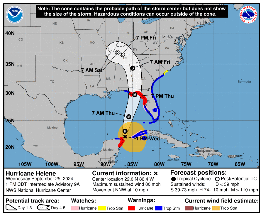
Forecast Track for Hurricane Helene, Courtesy of The National Hurricane Center.

With the speed and strength that Hurricane Helene will continue to gain, its impacts will be felt deep inland into the Southern Appalachians with damaging winds and intense rainfall.

Tropical storm-force winds are expected throughout Georgia and into the higher terrains of the mountains which will easily bring down trees and power lines, resulting in widespread power outages, as well as damage to property.

The Blue Ridge Mountains and Piedmont Region of Northern Georgia, Eastern Tennessee, and the Western Carolinas are also possibly looking at receiving up to 15 inches (381mm) of rain by the end of the weekend as the storm is expected to stall beginning late Friday over the Tennessee Valley. This much rain will bring a high risk of urban and flash flooding and landslides across the region. Meteorologists have already started to compare this to the 1916 flooding event in the Asheville, South Carolina area and impacts are expected to be greater than those from Tropical Storm Fred in 2021 and Hurricanes Frances and Ivan in 2004.


GOOGLE AD (NOT ENDORSED BY INSTANT WEATHER)

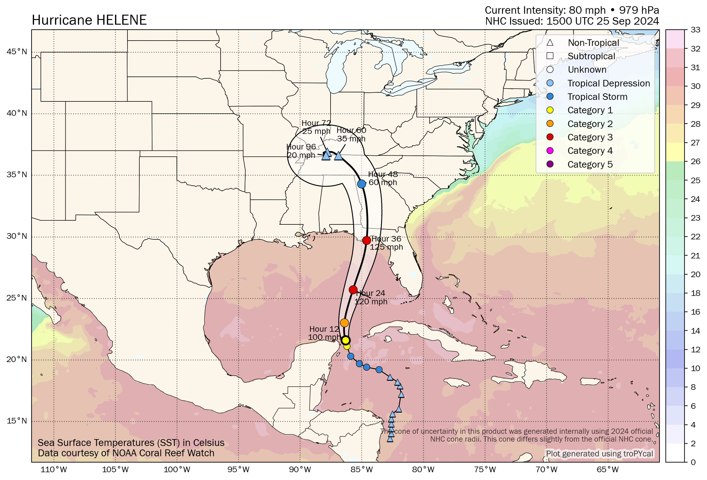
Helene will remain in an ideal environment for continued strengthening as it makes its final approach before landfall. It’s still located in an area with relatively low shear, strong upper-level divergence, as well as 30°C sea surface temperatures and warmth that extends deep below the surface. These conditions will allow the storm to further intensify from its current strength to a like high-end Category 3 Hurricane with isolated Category 4 level wind gusts.

There is still a bit of time before the storm hits to take necessary precautions to protect life and property. If you or your loved ones are in the path of the storm, please heed all directives from emergency personnel and stay safe!


Forecast Track and Intensity of Hurricane helene with Sea Surface Temperatures, courtesy of Tomer Burg.

Rapid Intensification of Helene to a Major Hurricane Expected in the Gulf as it Approaches Florida

Satellite Image of Hurricane Helene from September 25th at 11:26Am EDT, Courtesy of Colorado State University.

Tropical Storm Helene became a Category 1 Hurricane this morning as it continues to track offshore of the Yucatan Peninsula with maximum flight-level wind gusts measured at 81 knots (93mph or 150km/h) by recon flights. Based on this data, it is estimated that the maximum surface winds are 70 knots (81mph or 130 km/h). This is only the beginning of the strengthening of this storm as it is expected to rapidly intensify over the next 24 hours into a major Category 3 Hurricane as it bears down on the Florida Panhandle and Big Bend Coast.


GOOGLE AD (NOT ENDORSED BY INSTANT WEATHER)

The latest forecast track from the National Hurricane Center (NHC) shows that Helene is expected to turn northward and then north-northeastward later today and it will maintain that track as it makes landfall in Florida as a Major Hurricane.

At this point, it is still a bit too early to predict the exact location that Helene will make landfall along the Florida coast, but given the sheer size of the storm, the impacts will be widespread across the state. The storm has a massive wind field and tropical storm-force winds are already pushing their way into the Keys. These strong winds will gradually make their presence known further northward throughout the evening and overnight tonight, reaching the Panhandle tomorrow morning. Winds will increase in strength as the storm makes its final approach, with devastating hurricane-force wind gusts up to 125mph (200 km/h) projected for areas closest to where the storm will make landfall.

Inundating rainfall causing widespread flooding is also a major concern with Hurricane Helene across Florida with over 5 inches (127mm) of rain expected along the coast and lesser amounts of under 2 inches (51mm) further inland. Rainfall totals could easily exceed 10 inches (254mm) throughout the Panhandle.

Along with intense winds and flooding rainfall, life-threatening storm surge is expected along the entire Gulf Coast of Florida and the Big Bend Coast could see water levels exceeding 10ft. These factors all combined have prompted widespread Hurricane and Tropical Storm Warnings, evacuations, and States of Emergencies in almost every county in the state.


Forecast Track for Hurricane Helene, Courtesy of The National Hurricane Center.
Beyond landfall, the storm is expected to pack quite a punch through the rest of the Southeast and into the Ohio Valley with intense winds and heavy rainfall.

The destructive wind gusts will push their way well inland into Southern Georgia and even as far north as the Southern Appalachians. These strong winds will easily bring down trees and power lines, resulting in widespread power outages, as well as damage to property.

The Blue Ridge Mountain and Piedmont Regions of Northern Georgia and the Western Carolinas are also possibly looking at receiving up 12 inches (305mm) of rain by the end of the weekend as the storm is expected to stall beginning late Friday. This much rain will bring the risk of flooding and landslides across the region.


GOOGLE AD (NOT ENDORSED BY INSTANT WEATHER)

Helene will remain in an ideal environment over the next 24 hours with sea surface temperatures above 30°C, relatively low shear, and strong upper-level divergence, all key for rapid intensification of a tropical storm/hurricane. There is a bit of uncertainty of exactly how strong Hurricane Helene will become, with some weather models suggesting it could reach Category 4 strength, however, it is increasingly likely that it will make landfall as a Category 3 Hurricane.

It is not too late to take necessary precautions to protect life and property ahead of this storm. If you or your loved ones are in the path of the storm, please heed all directives from emergency personnel and stay safe!


Forecast Track and Intensity of Hurricane helene with Sea Surface Temperatures, courtesy of Tomer Burg.