Hurricane Ernesto's Track Through Atlantic Canada Becoming Clearer; Could Maintain Category 1 Strength Deep into Canadian Waters
/
Forecast track for hurricane Ernesto from the Canadian Hurricane Centre - August 17th at 9Am
Hurricane Ernesto made landfall on Bermuda early this morning as a Category 1 Hurricane. The storm luckily weakened from a Category 2 in the few hours before landfall, but it still packed a punch with 135km/h winds. Now the storm will continue to churn northeastward into Atlantic Canada for the beginning of next week.
The Canadian Hurricane Centre is now issuing their own forecast track and there has been very little change in their prediction with their 9am update compared to the maps from the past two days. They maintain that the centre of Ernesto will stay well offshore of Nova Scotia and pass south of the Avalon Peninsula. Major weather models have made a shift since yesterday morning and now there is agreement that the centre of the storm will stay off the coast of Newfoundland. This is certainly good news because this will keep the strongest winds from hitting land, but it will still be an impactful storm.
Now that we’re starting to see a clearer picture of Hurricane Ernesto’s path through Atlantic Canada, we can more accurately forecast the impacts of the storm, especially for the Maritimes. Pounding surf will hit the Atlantic Coast of Nova Scotia beginning late Sunday and continuing through Monday. Rip currents will also be a concern in these coastal areas. Light rain from the storm will spread across Nova Scotia and even into PEI and Southern New Brunswick, with rainfall totals at this point expected to be in the 5-30mm range across the region for Monday. Exact amounts and locations will become clearer by this time tomorrow. Since the storm will be passing so far offshore, winds will not be a concern in the Maritimes.
Newfoundland, particularly the Burin and Avalon Peninsulas, will get hit harder than the Maritimes since Ernesto will be passing much closer. Southwest-facing coastlines can expect to begin seeing the ocean swell from the storm beginning late Sunday with large waves and hazardous surf starting late Monday and continuing into Tuesday. These waves and the storm surge will likely result in coastal flooding along these southwest-facing shores. Since Ernesto is expected to pass close to the Avalon late Monday, the winds won’t be as strong on land as they will be closer to the centre of the storm. Nonetheless, wind gusts of up to 100km/h can be expected along the southern shores of the Avalon, especially from Saint Vincent’s to Cape Race, and weakening further inland. Rainfall will be heavy for a brief period of time late in the day Monday for Eastern Newfoundland, including into Bonavista. Light rain will spread across the rest of the Island ahead of the storm Monday afternoon. It is still a bit too early to predict exact totals, but at this point the Avalon could see 30-50mm of rain in a 6 hour period.

Model Forecast Tracks for Hurricane Ernesto, Courtesy of Tomer Burg.
While the track of Ernesto through Atlantic Canada has become clearer, the intensity at which it will travel through the region appears to have also become clearer. The Canadian Hurricane Centre predicts that Ernesto will maintain hurricane strength up to its final approach of Newfoundland, with winds of 120km/h, which is just above the threshold for a storm to be considered a hurricane. Then, just as it passes south of the Avalon, it will transition to a post-tropical storm.
Previous forecasts from the CHC/NHC showed that Ernesto would weaken somewhere between being offshore of Nova Scotia and around the Avalon, with no indication of where this transition may take place. This has now become clearer now that the storm has passed over Bermuda. Ernesto will experience a decrease in shear, giving the storm a chance to recover from ingesting so much dry air and it will undergo a short period of restrengthening tomorrow before hitting the point in which sea surface temperatures drop below 26°C and it begins to lose fuel. The image below shows that wind speeds at the storm’s centre will increase between Hour 24 and Hour 48, indicating this window of restrengthening. As a result of this strengthening in the storm, it will then take a bit longer to weaken to a post-tropical storm and it will maintain its status as Category 1 Hurricane deeper into Canadian waters. We will continue to monitor the storm and we will have our own rain and wind forecasts coming later tomorrow.
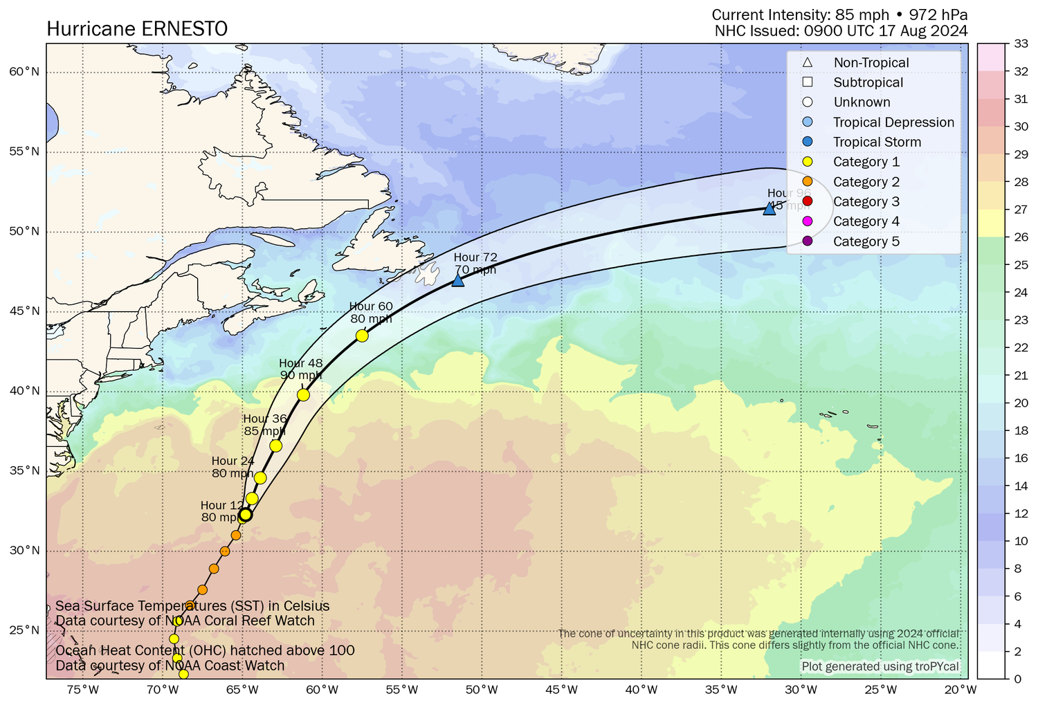
Forecast Track and Intensity of Hurricane Ernesto with Sea Surface Temperatures, courtesy of Tomer Burg.


