Looking Back on Canada's Costliest Winter Disaster: The Ice Storm of January 1998

A downed hydro pylon in Quebec following the ice storm in January 1998, courtesy of CBC News.

As Canadians rang in the New Year in January 1998, millions were unaware that in only a few days, they’d be caught in the middle of the costliest natural disaster in Canadian history. This is a record that stood for over 18 years, until the Fort McMurray fire of 2016. Nevertheless, it remains the most expensive winter disaster Canada has ever seen.

A 40,000km² area that covered Eastern Ontario and Upstate New York, up the St Lawrence Valley through Montreal, into the Eastern Townships of Quebec and across Maine into New Brunswick was coated in up to 100mm of ice that fell as freezing rain from the 5th until the 10th of January 1998. Light freezing rain was even experienced in Waterloo Region, to the west of Toronto and extended as far east as Western Nova Scotia. It’s important to note that this wasn’t a single storm, but rather a series of three smaller storms that produced freezing rain and ice pellets over an almost week-long period.

The Christmas Break in December 1997 was cold and snowy across much of Southern Ontario and Quebec so it was refreshing when New Year’s Day brought mild temperatures and sunshine to the region. However, a concerning weather pattern was shaping up.

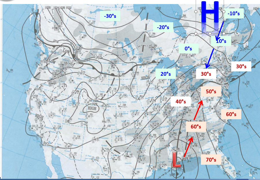
The surface chart from January 7th, 1998 showing the positions of the high and low pressure, areas of precipitations (shaded in darker grey) and the temperatures in degrees Fahrenheit, courtesy of the National Weather Service.

In the coming days, a strong high pressure area settled over Northern Quebec, which forced cold Arctic air southwards, while multiple low pressure systems from the south funnelled warm, moist air northwards. When the two air masses collided, the warm air rose above the cold air and then when the rain fell from the warm air mass, it froze on contact with surfaces at ground-level where the air was much colder.

This is what typically occurs in freezing rain events, but what made this different was the persistent flow of warm, moist air straight from the Gulf of Mexico continuing over several days, turning this into a prolonged event.

Temperature Profiles and the formation of different precipitation types.

The moist Gulf air arrived first, on January 4th, and brought mild temperatures and light rain to most of the impacted region. The next day, the Arctic air moved in and settled below the warmer air mass, bringing surface temperatures back below freezing and resulting in the transition from rain to freezing rain.

The high pressure continued to build over Northern Quebec throughout the following days, which maintained the flow of Arctic air, while the moist Gulf air surged northward in three distinct rounds of precipitation. According to Environment Canada, these three waves were: from 6:00pm on January 5th to 8:00am on January 6th, from 6:00pm on January 7th to 8:00am on January 8th, and from the morning of January 8th until the morning of January 9th.

Overall, an average of 50-70mm of freezing rain fell across the entire region. However, an area later called the “Triangle of Darkness”, between the towns of Saint-Hyacinthe, Granby, and Saint-Jean-sur-Richelieu, was hit the hardest, with more than 100mm of ice accretion.

Total Ice Accretion amounts from the January 1998 Ice Storm, courtesy of the National Weather Service.

Map of the total Ice Accretion from the January 1998 Ice Storm, with a Focus on Eastern Ontario and Southern Quebec, Courtesy of Hydro Quebec.

It didn’t take long for the effects of the ice buildup to be felt. Transportation quickly came to a halt as roads and sidewalks became skating rinks and vehicles were completely encased in ice.

After 10-20mm of freezing rain from the first round of precipitation, tree branches were already bending under the weight of the ice and as more freezing rain fell, the branches broke and entire trees toppled. Residents reported that the continuous sounds of ice-covered trees and branches breaking and falling was akin to gunshots. No definitive number was ever established, but it is estimated that millions of trees fell as a result of this storm.

It was also early on in the event that the strain on the power grid was felt and it only got worse as the freezing rain continued. Transmission lines sagged with the extra weight and short circuits caused by ground wires sagging and touching live wires tripped switches. Fasteners responsible for holding these lines were unable to handle the extra weight from all of the ice and snapped, while entire hydro poles and large towers eventually collapsed.

On top of all of this, transformers were damaged and caught fire, leading to further destruction of the hydro distribution system. Overall, 1,000 hydro pylons crumpled and at least 30,000 hydro poles were destroyed, plunging over 4 million people in Ontario, Quebec, and New Brunswick into darkness.

A montreal street covered in ice from the January 1998 ice storm, courtesy of Hydro Quebec.

While most people who were impacted by the ice storm were in urban areas, two groups in particular were significantly impacted in rural regions.

The stretch of the country hit by the ice storm was home to roughly 25% of all dairy cows in Canada and farmers encountered considerable challenges with the loss of power. Many cows got sick when it became difficult to feed them, milk them, and keep them warm.

With the lack of power at processing plants, over 10 million litres of milk, worth roughly $5 million, had to be dumped. Hydro Quebec reports that it was able to provide generators to many cattle farmers in the province, but unfortunately an estimated 300,000 farm animals across the entire region died in the cold.

Quebec’s maple syrup industry also took a massive hit with the ice storm. More than 20% of syrup-producing trees were damaged or destroyed as branches fell or large pieces of the trees splintered off, and equipment collapsed under the weight of the ice. Some syrup producers had their entire sugar bushes destroyed and while trees and the industry have mostly recovered, some scars still remain.

A convoy of troops deployed from Petawawa en Route to aid victims of the ice storm, taken January 9th, 1998, Courtesy of Veterans Affairs Canada.

On January 7th, at the peak of the ice storm, the Provincial Governments of Ontario, Quebec, and New Brunswick appealed to the Federal Government for assistance. The next day, 15,000 members of the Canadian Armed Forces were deployed from 200 different units from across the country as part of Operation Recuperation, making this this largest peacetime deployment of troops in Canadian history.

Troops worked with hydro companies to help restore power, cleared tree limbs and other debris, evacuated residents, and provided shelter, food and medical care to victims. The Operation eventually concluded on February 28th, 1998.

Due to the sheer level of damage across such a large area, the cleanup of debris and restoration of power was not something that was going to occur overnight. Temperatures plummeted following the ice storm to -20°C, so staying warm was the number one concern in the aftermath.

Many people were able to stay with family and friends who still had power, but emergency shelters were set up and available for those with nowhere else to go. Approximately 600,000 people were temporarily displaced from their homes while crews worked to restore power.

Thankfully, hydro crews from across the country and the United States came to the aid of those in the disaster area. The power was restored to many people in urban areas after a few days, but efforts took longer in rural communities, with roughly 700,000 people still without power three weeks after the storm.

The ice storm was a real testament to the sense of community as well as the welcoming and giving nature of Canadians. Many people came together to help clean up and provide food and shelter to those in need. Despite all this, the storm resulted in 945 injuries and 35 people sadly lost their lives.

On top of the human cost, the storm had a very large financial cost. The incredible amount of damage caused by this storm was estimated to have cost insurers $1.38 billion. Furthermore, entire cities were shut down and 2.6 million people in Ontario and Quebec, consisting of close to a fifth of the Canadian workforce, unable to get to work. The loss of productivity was over $1 billion and when added to insured damages and the over $2 billion it cost to repair utilities, the overall financial cost of the storm is estimated at $5.4 billion.


Further Reading:

https://canadiangeographic.ca/articles/lessons-learned-from-the-ice-storm-of-1998/

https://www.cbc.ca/news/canada/montreal/ice-storm-1998-1.4469977

https://www.hydroquebec.com/ice-storm-1998/

https://www.thecanadianencyclopedia.ca/en/article/ice-storm-1998

https://www.veterans.gc.ca/en/remembrance/wars-and-conflicts/caf-operations/service-in-canada/ice-storm

https://www.weather.gov/btv/25th-Anniversary-of-the-Devastating-1998-Ice-Storm-in-the-Northeast

Retrograding Storm Returns to the Maritimes, Bringing Up to an Additional 30cm of Snow

NOTE: YOU CAN CLICK ON THE MAP TO OPEN A ZOOMABLE IMAGE

It seems as though the storm from the weekend isn’t quite finished with the Maritimes. There have been scattered flurries across the region throughout the day Tuesday, but more organized bands of snow are on their way.


The snow will move into Northern New Brunswick from the north early Wednesday morning and spread southward into the region. By sunrise, the snow will reach Prince County, PEI and then Northern Nova Scotia by the early afternoon. This band of snow will last for up to 12 hours, but the snow will be light and come in bursts, resulting in up to 5cm of accumulation.


In the late afternoon and early evening, a second band of snow will push southward into Northern New Brunswick and following the same path as the first. This round will bring another 12 hours of steady snow across the region before starting to dissipate early Thursday morning. There will be pockets of heavier snow in this second wave, which will drive snowfall totals above 10cm in some parts of the Maritimes.


The snow will taper off throughout Thursday morning, but in the late morning to early afternoon, one final round of precipitation will move in. This third and final round will arrive after temperatures climb above freezing, resulting in mostly rain falling, but a bit of snow mixed in, across the Maritimes Thursday afternoon and into early Friday morning.


From these three rounds of precipitation, we’re looking at widespread snowfall totals of 5-20cm across the Maritimes. There will be areas where the snow will persist into late Thursday morning from the second round of snow, particularly the Annapolis Valley and at higher elevations in Northern New Brunswick. There will also be areas where more snow than rain will fall in the third round, namely the Northumerland Shore and the Cape Breton Highlands. The Highlands will see the most snow, up to 30cm, due to steady and often heavy snowfall over the duration of this event.

First Major Winter Storm of the Year is Taking Aim at Cape Breton Island With Over 50cm of Snow Possible

NOTE: YOU CAN CLICK ON THE MAP TO OPEN A ZOOMABLE IMAGE

The new year is starting off with a bang in parts of the Maritimes with the arrival of a major winter storm. While Newfoundland will feel the brunt of the storm, Eastern Nova Scotia and Prince Edward Island can expect a significant amount of snow and strong winds throughout the day Sunday and into Monday. The rest of the Maritimes, meanwhile, will experience little to no impacts from the storm.


The storm has been rapidly intensifying during its approach towards Atlantic Canada throughout the day Saturday, meeting the criteria of a bomb cyclone (a drop in internal pressure of at least 24mb in 24 hours).

The western edge of the storm will briefly skim along the far eastern coast of Cape Breton Island early Sunday morning as the storm surges north towards Newfoundland, bringing snow and wind gusts of 70-90km/h. The storm will continue to grow in size as it gains latitude, which will push the snowfall and intense winds deeper into Cape Breton as the morning progresses.


By the mid-morning, the storm is expected to shift and start moving along a more northwesterly track, which will bring the snow and strong winds into Eastern Mainland Nova Scotia, across Prince Edward Island, and briefly to the eastern tip of the Acadian Peninsula. Blowing snow will greatly reduce visibility across the area throughout the day and could even lead to blizzard conditions.

The storm will gradually lose momentum later in the afternoon before completely stalling for several hours in the late evening and overnight. This will result in the impacted areas of PEI and Nova Scotia seeing snow quickly accumulate and the strong winds continuing while also limiting how far westward into the rest of the Maritimes that the snow spreads.

Model run showing Snow (Blue) and Rain (green) at 11pM on Sunday, January 5th


At around sunrise on Monday morning, the storm will start to fall apart, with the snow tapering off and the winds dying down across PEI and Mainland Nova Scotia throughout the morning. By the early afternoon, the only snow falling will be in the Cape Breton Highlands, where it will continue until the late evening.

The Cape Breton Highlands will be the hardest hit area and heavy snow is expected to fall for 24 hours at up to 5cm/hr, leading to over 50cm of accumulation here. This area will also see the strongest wind gusts from the storm, up to 100km/h, making travel very treacherous and possibly resulting in power outages.

One Last Pre-Holiday Blast of Winter Could Make Travel Difficult in the Maritimes with up to 30cm of Snow

NOTE: YOU CAN CLICK ON THE MAP TO OPEN A ZOOMABLE IMAGE

There’s more snow on the way for the Maritimes following the storm over the weekend. The next system that will hit tomorrow, Christmas Eve, and continue into Christmas morning, will once again negatively impact the holiday travel plans for many across the region.


New Brunswick

The snow will start to push into Western New Brunswick around midnight tonight and spread eastward across the province before sunrise tomorrow. By that point, the snow will already have tapered of in the Northwest, leading to less than 5cm of accumulation in this area. As we progress through the morning, the snow will start to gradually diminish across western parts of Northern and Central New Brunswick as the system tracks southeastward.

Meanwhile, a bit of intensification is expected, leading to much of the province receiving over 10cm of snow by the end of the day. Pockets of particularly heavy snow are likely through the afternoon along the Fundy Coast, with the snow falling at up to 5cm/hr. This is expected to bring snowfall totals to over 20cm for this area, including Saint John, and over 30cm locally in areas of higher elevation.


The system will continue tracking southeastward across the province throughout the afternoon and early evening, at which time the entire system starts to fall apart. This will lead to scattered flurries lingering overnight and the early morning in Southeast New Brunswick.

Prince Edward Island

The snow will start in PEI a couple of hours before sunrise in Prince County, spreading across the rest of the Island throughout the morning and into the early afternoon. By the time the snow reaches the eastern edge of Kings County in the mid to late afternoon, this area will see snowfall for only a few hours before the system starts to break down. As a result, this area can expect less than 5cm of snow while the rest of the Island will receive upwards of 10cm.

There could be some lingering flurries for PEI overnight and into Christmas morning, but these will only add on another centimetre or two to the final snowfall totals.


Model run showing Snow (Blue) and Rain (green) at 4pM on Tuesday December 24th


Nova Scotia

The snow will make its way into both Northern and Western Nova Scotia from the northwest starting in the early morning before sunrise. It will push deeper across the province through the morning and early afternoon, but it is not expected to cross very far into Cape Breton, if at all. Isolated flurries can’t be completely ruled out here so our forecast is for up to 2cm of snow for this area.

The temperatures will rise throughout the day with the arrival of the storm and will climb above freezing in parts of Western Nova Scotia. Those living inland will see temperatures of 1°C, resulting in the buildup of heavier, wet snow. On the other hand, coastal communities in Yarmouth, Shelburne, and Queens Counties are expected to get up to 3°C and the snow will transition to rain, limiting overall snowfall totals to 5-10cm.

In the evening, the system will fall apart, leading to pockets of precipitation occurring across the Mainland for a few hours. Later into the evening and overnight, the snow is expected to persist over Western Nova Scotia and with temperatures remaining a degree or two above freezing, the snow that falls will be very wet and mixed with some rain. This will bring snowfall totals closer to 20cm and locally higher for parts of the Annapolis Valley.


This system is unfortunately very ill-timed and will really impact the plans that many people have to travel and visit family over the next couple of days. Thankfully, most of the snow will be finished by Christmas morning so day-of holiday travel shouldn’t be too tough.

Wind gusts should top out at about 50km/h on Tuesday, with the strongest gusts expected in Southern New Brunswick and Western Nova Scotia so visibility could be limited at times with brief whiteouts, but we won’t be at risk for full blizzard-like conditions.

Since the chances for a White Christmas across the Maritimes seem fairly obvious at this point, with Guysborough County and Southern Cape Breton just hitting the 2cm threshold along with the arrival of even more snow on Christmas Eve, we will not be updating our preliminary White Christmas Forecast. Enjoy your White Christmas everyone!

A Rare Region-Wide White Christmas Appears to be in Store for the Entire Maritimes This Year

NOTE: YOU CAN CLICK ON THE MAP TO OPEN A ZOOMABLE IMAGE

White Christmases are not a common occurrence for the Maritimes, especially for the entire region, since the late fall is typically mild and rainy. They are so rare in some parts of the region that it has been over a decade since one was last experienced. This year has been fairly average up until very recently and with Christmas now only 3 days away, the odds of a White Christmas across the Maritimes is becoming quite clear.


According to Environment Canada, in order for an area to have a White Christmas, there needs to be at least 2cm of snow on the ground as of 7am on Christmas Day. After Saturdays’s Nor’easter, the snowpack across most of the region is at least 5cm deep. The exception to this is in Guysborough County and into Southern Cape Breton Island, where rain and positive temperatures ended up melting some of the snow that had already fallen from the storm. At this point, it looks like this area just barely reaches the 2cm threshold for a White Christmas.

Looking ahead to the next few days, temperatures reaching only a degree or two above freezing in some areas and the arrival of more snow on Christmas Eve will help solidify the chances for a White Christmas across the Maritimes.

Modelled Snow depths, in centimetres, as of Sunday, December 22nd at 8am aT.


New Brunswick

Temperatures across most of the province are expected to remain below freezing between now and Christmas morning so the snow that is already on the ground is here to stay. A system moving in early Tuesday morning will bring snow to the entire province throughout the day. The heaviest snow is expected to fall in Southern New Brunswick and up to 20cm may accumulate. Although temperatures along the Fundy Coast may creep into the single digits on Tuesday with the arrival of this system, it won’t be enough to melt all of the existing and incoming snow. As a result, all of New Brunswick can expect a White Christmas.

Prince Edward Island

Similar to New Brunswick, temperatures across PEI are expected to remain below 0°C until after Christmas morning. Snow will reach the province before sunrise on Christmas Eve and continue into the evening, adding to the existing snowpack and guaranteeing a White Christmas for the entire Island.

NOTE: YOU CAN CLICK ON THE MAP TO OPEN A ZOOMABLE IMAGE


Nova Scotia

The chances for a White Christmas vary slightly across Nova Scotia. Given the shallow depth of the snowpack in parts of Eastern Nova Scotia, chances are high, but not a guarantee and just a little bit of melting could spoil things. Luckily as of now, it appears that any melting might not happen in this area until the afternoon on Christmas Day when temperature rise above the freezing mark.

Snow is expected to move into Western Nova Scotia early Tuesday morning and will cross the province through the remainder of them morning. Although it is expected to be light and fairly brief, the additional snow will be welcome news for those in Eastern Nova Scotia who are hoping for that traditional White Christmas. This extra snowfall keeps the odds of a White Christmas high in the areas of shallow snowpack, barring any major melting that might occur a little ahead of schedule.

The snow will be heavy at times across parts of Western Nova Scotia, leading to over 10cm of accumulation. Temperatures in this area are anticipated to climb into the single digits, particularly along the shorelines, so it’s possible that there will be a transition over to rain, but this isn’t expected to be enough to ruin the chances of a White Christmas. Some weather models are even suggesting that the snow could continue to fall in Western Nova Scotia into Christmas morning, leading to what some consider to be a “true” White Christmas!


Please keep in mind that this is just a preliminary forecast, along with the first look at the incoming snowfall, and this is based on current data. The full forecast for the incoming snow will be posted Monday afternoon/evening and the final White Christmas forecast is coming Christmas Eve morning. Make sure to stay tuned!

Nor'easter With Intense Snow Will Hinder Pre-Holiday Travel and Almost Promise a White Christmas in the Maritimes

NOTE: YOU CAN CLICK ON THE MAP TO OPEN A ZOOMABLE IMAGE

It is going to start to look like Christmas across the Maritimes this weekend. The Nor’easter mentioned in yesterday’s preliminary forecast is making its way towards the Maritimes and will reach our shores this evening. While the low pressure center will pass south of Nova Scotia, the storm will bring 20-30cm of snow across some or all of the three Maritimes provinces.


Nova Scotia

Light snow will begin in Western Nova Scotia this evening, around 7-9pm, and spread eastward across the province throughout the remainder of the evening and overnight. The snowfall will quickly intensify, falling at close to 5cm/hr in some areas and continuing for several hours. This period of intense snow will result in widespread snowfall accumulations 20-30cm and possibly even higher locally before sunrise for most of mainland Nova Scotia.

In Guysborough County and into southern parts of Cape Breton Island, the snow will transition to ice pellets for a couple of hours, starting at around 3am as some of the warmer air from the storm pushes northward. This will limit snowfall totals in the area to 10-20cm.


Model run showing Snow (Blue), Rain (green), and Ice Pellets (Orange) at 4AM

The eastern half of the province will see a break in the precipitation before dawn, but the heavy snow will taper to light snow in the west which will continue through the morning. By noon, that snow will start to push eastward, possibly with a bit of light rain preceding it. The snow will start to taper off in Western Nova Scotia in the mid-afternoon and should end for most of the province by the evening. Some stray flurries will linger overnight and into Sunday morning, by they will provide very little additional accumulation.


New Brunswick

The entirety of New Brunswick can expect snow from this Nor’easter, but given its offshore track, the heaviest snow will be in the southeast and totals will decrease going northwest.

The snow will reach the Fundy Coast around midnight tonight and spread northward during the early morning hours. Southeastern New Brunswick can expect some heavy snow for a couple of hours that will quickly drive up accumulations. The snow will begin to taper off after sunrise, starting in the northwest and gradually through to the southeast by Saturday evening. This will bring snowfall totals in the southeast corner of the province above 20cm by the end of the day.

Prince Edward Island

The leading edge of the Nor’easter will cross into PEI shortly after midnight tonight. The snow will be continuous and last straight through to late Saturday evening. The snow will be heavy at times across the Island, falling at up to 2cm/hr and while not as heavy as expected in Nova Scotia, this will be enough to result in over 20cm of snow for the entire province.


Given that this is one of the busiest weekends of the year for travel, this storm will likely result in many headaches across the Maritimes. Heavy snow is already a pain to drive in, but widespread wind gusts up to 60km/h, and locally as high as 80km/h, will lead to blowing snow throughout the day Saturday. Not only will the roads be treacherous, but airports will likely have a handful of delays and cancellations due to the storm. Please give yourselves plenty of extra time if going out on Saturday and if possible, consider postponing any travel until Sunday.

For those who look at this storm as the chance for a White Christmas in over a decade in some places, there’s good news! Temperatures are not expected to climb above freezing until later next week so the snow will stick around.

Dreaming of a White Christmas? Incoming Storm Will Almost Guarantee One for the Maritimes!

NOTE: YOU CAN CLICK ON THE MAP TO OPEN A ZOOMABLE IMAGE

It hasn’t really looked like the holiday season across the Maritimes lately, with grass still visible throughout the region. There’s been very little snowfall in Nova Scotia and PEI and the existing snowpack in New Brunswick melted just last week. A skiff of snow fell across New Brunswick overnight and this morning, but that’s the extent of the snow on the ground for pretty much the entire region. For those in the Christmas spirit though, that’s all about to change.


Starting Friday evening, a Nor’easter will move into the region that is expected to bring considerable heavy snow across most of Nova Scotia and into PEI and Southeastern New Brunswick. Weather models are currently projecting widespread snowfall accumulations of 20-30cm for that particular area and lower totals for the remainder of New Brunswick by Saturday evening.

The amount of snow expected in Guysborough County and much of Cape Breton Island is lower because some mixed precipitation is expected. Where, and how much of, this mixed precipitation falls will be entirely dependent on the track of the storm and there is still a bit of remaining uncertainty in that regard.


While some may be celebrating the likelihood of a White Christmas, the snow will certainly have negative impacts on early holiday travel this weekend. Not only will the heavy snow be a chore to drive in, widespread wind gusts up to 60km/h, and locally as high as 80km/h, will create even more hazardous conditions due to blowing snow. On top of that, there is the possibility of some isolated power outages with the strong winds.

This is only our preliminary look at the storm so check back tomorrow for a more in-depth forecast once the track of the storm becomes a bit clearer.

Rapidly Strengthening Bomb Cyclone Expected to Bring Heavy Rain and Wicked Winds to the Maritimes

NOTE: YOU CAN CLICK ON THE MAP TO OPEN A ZOOMABLE IMAGE

Hang on to your umbrellas! We have an incoming bomb cyclone that is set to not only drench the Maritimes, but bring some intense winds to the region as well. A bomb cyclone is a storm that undergoes rapid intensification, called bombogenesis, that results in a drop in central pressure of at least 24mb over a 24 hour period. A system has begun travelling northward along the American Atlantic Coast and the further north it travels, the stronger it is expected to become under this rapid intensification.

The storm will bring precipitation to the Maritimes in two rounds. It will start off with warm, moisture-laden air being funnelled up from the Gulf along the warm front, leading to temperatures climbing into the double digits. Following a break in the precipitation from the first round, the length of which will be dependent on the distance from the centre of the storm, a second round of rain will move in along the cold front. Behind this cold front, temperatures are expected plummet and will fall below 0°C across New Brunswick, leading to the risk of a flash freeze. Combined, these two rounds of rain will bring a widespread 10-50mm of rain across most of the Maritimes.


New Brunswick

Things in New Brunswick will certainly get messy over the coming days due to this incoming storm. The first wave of precipitation will move into Western New Brunswick around sunrise Wednesday morning. The temperatures will rise with the arrival of the warm front and rain, but there will still be some isolated pockets of cold air near the surface that could persist for several hours, leading to freezing rain. Luckily any ice accretion will quickly melt as temperatures rise.

The rain will continue throughout most of the day and it will start to taper off, from south to north beginning in the evening. Due to its proximity to the centre of the storm, there won’t be a break between to the rounds of precipitation in Northwest New Brunswick. As a result, this is where the highest rainfall amounts of close to 50mm are expected. The rest of the province will start to see this second wave move in from the west overnight. It will lose intensity as it pushes eastward and the heaviest rain will fall over the western half of the province, where 25-50mm of rain is expected overall with the storm and only 10-25mm to the east. This second round won’t last long and will exit the province by the late morning.

There will be a unique problem in New Brunswick that the rest of the Maritimes won’t have to worry about. Some parts of the province have a considerable snowpack over 30cm which will end up melting with temperatures rising into the double digits through the day Wednesday. However, when combined with the amount of incoming precipitation and the ground likely remaining at least partially frozen, standing water and flooding becomes a concern. To make matters worse, the temperatures will drop drastically across most of the province overnight Thursday, to well below the freezing mark, which could lead to a widespread flash freeze.

NOTE: YOU CAN CLICK ON THE MAP TO OPEN A ZOOMABLE IMAGE


Nova Scotia

The scenario across Nova Scotia with this storm will be a little less complicated, in regards to precipitation. The first wave of rain will make its way into Western Nova Scotia in the mid to late morning Wednesday. The rain will be heavy at times across the western half of the Mainland and it will then dissipate across the province through the evening. The second round of rain will then arrive early Thursday morning and is only expected to last 4 hours or so as it crosses the province, before the storm finally makes its way out of the region in the evening. Most of Mainland Nova Scotia and along the South Coast of Cape Breton Island can expect 10-25mm of rain while the rest of the province will see 5-10mm

Prince Edward Island

Prince Edward Island, much like Nova Scotia, has a fairly straightforward forecast with this storm. The first wave of rain will impact the Island starting early Wednesday afternoon and continuing into the evening. Then, the second wave will move in after sunrise on Thursday and cross the Island in the span of 3-4 hours. Rainfall amounts of 10-25mm are likely in Prince and the western half of Queens County and 5-10mm in Kings County and the eastern half of Queens County.

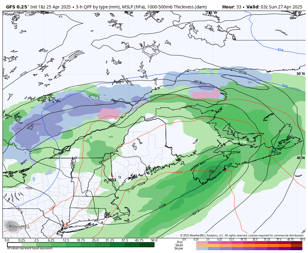
Strong winds will also be a factor with the incoming bomb cyclone. In this model image showing 1:00 AM Thursday, we can get a good look at both the size and structure of the storm, along with the precipitation types and their intensities. What we also see is the projected internal pressure of the storm, in millibars, as well as the lines of equal pressure, in black, known as isobars. Winds are driven by air moving from areas of high pressure to those of low pressure and when isobars are really close in strong storms, as seen in this case, we know that the winds will be quite strong.

The strong winds will start making their way into the Maritimes Wednesday evening and they will peak overnight. The entire region will get hit by sustained winds above 40km/h and gusts over 70km/h, but Western Nova Scotia and Southwest New Brunswick in particular will be hammered by gusts in excess of 100km/h. These will be onshore winds so pounding surf and some coastal flooding are very likely along the Atlantic Coast of Nova Scotia and along the Fundy Coast to the west of St. John starting late Wednesday and continuing through Thursday morning.

The Second Storm of the Week Should Finally Bring Nova Scotia's First Decent Snowfall of the Season

NOTE: YOU CAN CLICK ON THE MAP TO OPEN A ZOOMABLE IMAGE

For the second time in a week, more snow is on the way for the Maritimes, with another short-lived Alberta Clipper moving in to finish the weekend. Nova Scotians can once again expect rain with this system, but that won’t happen until after some snow accumulates, making this the first decent amount of snow across most of the province this season.


New Brunswick

The snow from the Clipper will arrive along the International border before sunrise Sunday morning and cross the province throughout the morning hours. The snow will be light to moderate, leading to a widespread 5-10cm across New Brunswick. Some light rain may mix with the snow along the Fundy Coast so snowfall totals could be limited here. Heavier snow is likely around Miramichi and into the Acadian Peninsula in the early afternoon, with snowfall rates reaching 2cm/hr and resulting in accumulations above 10cm in this area. By the early afternoon, the snow will start to taper off from west to east and ending in the evening.

Nova Scotia

The leading edge of the Clipper will push into Western Nova Scotia at around sunrise on Sunday. The western portions of the Annapolis Valley and South Shore will see this snow switch over to rain after only an hour or two, but as the system pushes further into the province through the morning, the snow will persist longer.

As we progress into the afternoon, the temperatures will rise to above freezing in mainland Nova Scotia, starting along the coasts and moving inland, causing the snow to transition to rain after only a few hours. As a result, snowfall totals will be higher, just above 5cm, in inland portions of the mainland and lesser along coastal areas. This snowfall won’t last and will quickly start to melt with the warmer temperatures and rain following it. The transition from rain to snow won’t occur until the evening in Cape Breton and the impacts of this will be limited overall. As usual, the higher elevations of the Highlands will remain cool, preventing a switch over to rain and resulting in snowfall accumulations above 10cm.

The system will start to make its way out of Nova Scotia starting in the late afternoon, with precipitation ending from west to east until finally exiting the province after midnight early Monday morning.

Prince Edward Island

The snow will reach Prince Edward Island around the lunch hour on Sunday and is expected to last throughout the afternoon before tapering off in the early evening. The snow is expected to be light, resulting in an almost province-wide 5-10cm of fresh accumulation with the exception of eastern King’s County, where temperatures will climb above 0° briefly in the evening and there will be a switch over to rain as the system finishes crossing the Island.

Mix of Wet and Wintry Weather on the Way for the Maritimes, Bringing More than 20cm of Snow to Parts of New Brunswick

NOTE: YOU CAN CLICK ON THE MAP TO OPEN A ZOOMABLE IMAGE

More snow is on its way for New Brunswick and in a similar fashion to last week’s storm, Nova Scotia can once again expect mostly rain with the possibility of a bit of snow mixed in. The incoming system will be a mix of an Alberta clipper coming through Ontario and a secondary low from New England, and it will be another short blast of winter for the region, with the entire event spanning 24 hours.


Things will start off around midnight tonight as snow from the Clipper pushes its way into New Brunswick. As the snow spreads eastward across the province through the early morning hours, the low from the States will merge with the Clipper, which will funnel even more moisture northward from the Gulf. This secondary source of precipitation will reach Western Nova Scotia in the pre-dawn hours. The merging of these two systems will result in some intensification starting later in the morning, leading to heavier snow and rain across the region.

Nova Scotia

Nova Scotia will once again find itself in the warm sector of this storm, leading to precipitation falling mostly as rain for the duration of this event. However, there is a chance for some snow showers since temperatures will be hovering just above the freezing mark in some areas along the leading edge of the storm. Unfortunately for snow lovers, no real snow accumulation is expected from this storm, with temperatures climbing throughout the day and resulting in any snow transitioning to rain. The exception to this is, once again, in the higher elevations of Cape Breton where temperatures will remain below 0°C until Thursday evening, leading to 5-10cm of snow. Widespread rainfall totals across the rest of the province are expected to be in the 20-40mm range.

New Brunswick

On the other hand, New Brunswick can expect to need the shovels at some point on Thursday. The snow from the Clipper will push its way across the province throughout the early morning, but as the rain reaches Nova Scotia, it will also push into the Fundy Coast area, limiting snowfall accumulation along this stretch. Once the two systems merge and the storm intensifies, snowfall rates could approach 3cm per hour in the afternoon across Central and Northern New Brunswick, leading to widespread snow accumulations above 10cm. In the early and mid-afternoon, warm air will wrap around the backside of the storm, resulting in a transition from snow to rain that will push northeastward into the evening. Temperatures will fall overnight, but the warm air, along with the rain, will result in the melting of some of the fresh snow across most of the province.

Prince Edward Island

The leading edge of the precipitation will reach Prince Edward Island around noon on Thursday, with some light snow that will last for several hours. This will bring up to 5cm of snow across the Island before the warm air moves in and the snow switches over to rain. Similar to New Brunswick, the warm air and rain will melt most, if not all, of the freshly fallen snow across the province throughout the evening.

The storm will start to dissipate in the early afternoon, with the arrival of the warm air in New Brunswick and it will fully exit the region shortly midnight and into Friday morning. There could still be some lingering flurries or pockets of light rain throughout early Friday morning.

First Taste of Winter With Up to 30cm of Snow for Parts of the Maritimes, More Rain in Nova Scotia

NOTE: YOU CAN CLICK ON THE MAP TO OPEN A ZOOMABLE IMAGE

As November comes to an end, the first winter storm of the season is headed for the Maritimes. Over the past few days, we’ve been monitoring the development of a potent winter storm in the U.S. that’s expected to track into the region through New England on Thursday.

Until Wednesday morning, there had been considerable disagreement between weather models regarding the exact track of the storm through the Maritimes and where the heaviest snow would fall. As the event has gotten closer, these models have started to come into agreement and now we have a clearer picture of what is on its way.


Precipitation will push into Southern New Brunswick starting Thursday afternoon. As the storm makes its way into the region, the precipitation will start off as rain in both New Brunswick and Nova Scotia before the snow starts to make its way into New Brunswick and eventually crosses into Cumberland County, Nova Scotia and Prince Edward Island. This means that most of the Maritimes can expect to receive a few hours of rain before the arrival of any snow. This storm will have a warm sector along its southern side, with temperatures remaining in the single digits, resulting in precipitation falling as rain across most of Nova Scotia for the duration of the event.

Both the rain and snow will start to intensify later in the evening, at which time the edge of the storm will reach PEI. Snowfall rates of up to 5cm/hr are likely at times in Central and Northeast New Brunswick overnight and into Friday morning, leading over 20cm of snow accumulation in a span of 12 hours.

In Nova Scotia, on the other hand, widespread rainfall amounts of 10-30mm are expected, adding to what has already been a very wet month for parts of the province. The Annapolis Valley and the Northhumberland Shore could see a brief transition from rain to light snow overnight with temperatures approaching the freezing mark, but little to no accumulation is expected. Meanwhile, the air in the higher elevations of the Cape Breton Highlands will be cool enough for snow to fall for the duration of the storm and the area can expect 5-10cm.

In Prince Edward Island, the heavy snowfall will cross into Prince County shortly after midnight, which will lead to higher snowfall totals in that part of the Island. We’re expecting to see some warmer air getting wrapped into the backside of the storm in the early morning hours of Friday, leading to a transition from rain to snow across Southern New Brunswick and into Cumberland County and PEI and limiting the snowfall totals in these areas as the storm continues to track through the Maritimes.

The rain is expected to start to taper off in Western Nova Scotia in these early morning hours, gradually ending across the province through the morning. The rest of the storm will then begin to exit the region just before sunrise with the precipitation eventually ending by mid-afternoon in Northeast New Brunswick.

Retrograding Storm Will Bring a Freezing Rain Threat To New Brunswick Friday

NOTE: YOU CAN CLICK ON THE MAP TO OPEN A ZOOMABLE IMAGE

It’s been an extended wet stretch through the Maritimes lately and that pattern is set to continue over the next couple of days. A low pressure system that has been bringing heavy rain and strong winds to Newfoundland has begun to retrograde and travel westward towards the Maritimes, where it is expected to bring even more rain to the already soggy region starting later tonight.


Most of the Maritimes can expect steady rain, that could be heavy at times, throughout the day Friday and into Saturday, with a widespread 5-30mm falling across the region and up to 50mm possible in the Cape Breton Highlands.

The leading edge of this storm, however, will encounter cool air over land in New Brunswick, with temperatures hovering around 0°C or just below, resulting in freezing rain falling for up to several hours. The freezing rain will begin in the early morning hours and gradually spread westward throughout the morning. As temperatures climb throughout the day, the freezing rain will transition to rain, but surfaces will still be quite slick with a thin layer of ice.

Up to 2mm of ice accretion can be expected across most of the province and closer to 4mm could be seen in the northwest where the cooler air will persist, leading to 4-6 hours of freezing rain. Areas along the eastern coast look like they will be spared from the freezing rain since temperatures are expected to stay a few degrees above freezing overnight. Make sure to take extra caution when travelling along icy roads and sidewalks tomorrow morning.

What's in a Name? Choosing the Right Tires to Drive you Through Canadian Winters

Tread patterns of summer, all season and winter tires. Image courtesy of discount tire.

Now that it’s the first week of November, many Canadians are starting to think about putting winter tires on their vehicles. There have been pockets of unseasonable warmth across the country in October and the start of November, the inevitable chill of winter is in the air, and many have already seen snow fall.

While winter tires are recommended throughout the country, they are mandatory in Quebec from December 1st to March 15th, and from October 1st to April 30th on certain British Columbia highways. Additionally, studded tires are allowed almost nationwide, with the exception of residents of Southern Ontario.

Insurance companies across the country offer discounts for installing winter tires as an incentive to encourage drivers to reduce the risk of accidents. So what makes winter tires that much better in the cold and snow than summer tires and where do all season and all weather tires fit into the mix?


With the right tools, it can be pretty easy to change your own tires!

Summer Tires

Summer tires are designed to handle both wet and dry road conditions with their wide tread and soft rubber. These tires also usually have deeper grooves that improve traction on wet roads and reduce hydroplaning, making them ideal for the wet spring and summer months.

Winter Tires

Like their name suggests, winter tires have been designed for winter roads. They are made with rubber that stays flexible at temperatures below 7°C (45°F), the magic number at which other tires become stiff and lose traction, greatly reducing their performance. Furthermore, winter tires have different tread patterns that are meant to divert water and slush to the sides, as well as little slits called sipes that increase the overall grip of the tires and helping them maintain contact with icy road surfaces. Over the past several years, tire manufacturers have started to include additional small particles, like crushed glass or walnut shells, that act as little studs on the surface of the tire for extra grip.


Performance of All Season Tires vs Winter Tires with decreasing temperatures. Image courtesy of Discount Tire.

All Season & All Weather Tires

Some people argue that winter tires aren’t necessary if they have all season tires on their vehicle. Unfortunately, this is a slight misnomer because while these tires can handle a bit of cold and snow, they fail to handle heavier snowfalls that are common in Canadian winters. All season tires, unfortunately, sacrifice traction in wet conditions that would be found in summer tires and some of the flexibility and grip seen with winter tires in order for the tread to last longer. Realistically, these should be called 3 season tires as opposed to all season. So while they’re not the best option for winter driving in Canada, all season tires are definitely a better choice than regular summer tires.

All weather tires, not to be confused with all season tires, are a true year-round tire designed to handle Canadian winters. Unlike all season tires, these tires remain soft and flexible well below 7°C. The tread pattern on all weather tires is a combination of all season and winter tires, making them better suited for driving through heavier snow than all season tires. While they still don’t match the performance of a true winter tire, all weather tires are the best option for those who don’t want the hassle of swapping out their tires twice per year or simply do not have the space to store an extra set. Their versatility truly makes all weather tires a middle of the road tire (pun intended) for Canadian drivers.


The three-peak mountain snowflake symbol found on winter and all weather tires. Image courtesy of Canadian tire.

When looking for tires to get you through the winter, it is recommended to chose either a proper winter tire or an all weather tire, so long as it has the three-peak mountain and snowflake symbol on the sidewall. This is an industry standard symbol which indicates that the tire meets strict regulations for winter performance; becoming mandatory on all winter tires beginning in 2018, transitioning away from just using the M+S (Mud and Snow) designation.


Further Reading

https://www.canadiantire.ca/en/how-to/automotive/how-to-choose-winter-tires.html

https://www.continental-tires.com/ca/en/tire-knowledge/winter-tire-laws-in-canada/

https://www.continental-tires.com/ca/en/tire-knowledge/winter-tire-markings/

https://www.discounttire.com/learn/tires-below-45

https://www.discounttire.com/learn/winter-summer-allseason

Note: The author formerly received payments from “Big Tire” however, this article was not funded.

Trick-or-Treat: A Potential Spooky ‘Headless’ Comet Could Be Visible Across Canada Around Halloween

It's been a spectacular year for skywatchers across Canada, with events like solar eclipses, supermoons, and vibrant northern lights lighting up the night. Now, it looks like we might be in for another treat—a "headless" comet could make an appearance just in time for Halloween.


October seems to be the month of comets, with Comet Tsuchinshan-ATLAS gracing the early evening skies recently. Many stargazers caught glimpses of the comet, which was visible in the western sky just after sunset. Although it has since faded from naked-eye visibility, you can still catch it with a telescope, and it will remain somewhat visible into early November.

But the cosmic show isn’t over yet. A second comet, called Comet ATLAS (C/2024 S1), may arrive just in time for Halloween, and it comes with a spooky twist—it could appear "headless." The comet’s name might sound familiar because it was discovered by the same ATLAS asteroid tracking system, known for spotting objects that could potentially impact Earth.


The main difference between this upcoming comet and the earlier one lies in its path. While the first comet passed safely between Earth and the Sun, around 40 million miles from the Sun, this new comet will come much closer, potentially within 700,000 miles of the Sun's surface. Because of this close approach, scientists predict that the comet’s head—its bright core—might disintegrate due to the Sun's intense heat, leaving just a faint, trailing tail visible from Earth.
To understand what makes a comet appear "headless," it's important to know a bit about its structure. Comets are made up of a nucleus, or core, composed of rock, dust, and frozen gases. When they approach the Sun, the heat causes the frozen gases to vaporize, forming a glowing coma around the nucleus and a tail that extends away from the Sun. If the nucleus disintegrates, the glowing head might vanish, leaving behind only a ghostly tail, hence the term "headless comet."


ESTIMATED BRIGHTNESS OF COMET - SOURCE: sKYWALK.SPACE

The exact visibility of this comet remains uncertain. It will come closest to Earth on October 24th as it travels toward the Sun, reaching its closest point to the Sun, known as perihelion, on October 28th. There’s even a chance it could be bright enough to see during the day, potentially appearing as bright as Venus from 7:12 AM to 8:06 AM (ET) in the east-southeastern sky.

However, those in the Northern Hemisphere may struggle to spot it due to its position low in the sky near the Sun, making it difficult to see without obstruction from sunlight or clouds.


NASA offers some tips for spotting the comet during this close approach. To view it safely, you should block the Sun with an object such as a building or tree, then scan the lower left of the Sun's position in the sky. Be cautious and never use binoculars or telescopes, as accidentally focusing on the Sun can cause serious eye damage.

If the comet survives its close encounter with the Sun, it could become visible in the night sky around Halloween. This would provide skywatchers with a unique opportunity to see a potentially "headless" comet, with a long, wispy tail but no visible nucleus. The darkness of the moonless night sky could offer ideal conditions for observing this unusual celestial visitor, making it a fitting cosmic event for the spooky season.


There is always the possibility that the comet disintegrates completely, leaving nothing visible to the naked eye. But if it endures, it will gradually fade after November 1st, requiring binoculars or a telescope for further observation. Unlike earlier this month, when a supermoon washed out the sky, the absence of a full moon could make for an even more impressive show, assuming the comet survives.

Stay tuned for updates as we keep an eye on this intriguing comet.

Why the Northern Lights Are Appearing More Frequently: NASA and NOAA Confirm Solar Maximum

Visible light images from NASA’s Solar Dynamics Observatory highlight the appearance of the Sun at solar minimum (left, Dec. 2019) versus solar maximum (right, August 2024). During solar minimum, the Sun is often spotless. Sunspots are associated with solar activity, and are used to track solar cycle progress. Credit: NASA/SDO

During a recent teleconference, experts from NASA, NOAA, and the International Solar Cycle Prediction Panel confirmed that the Sun has entered its solar maximum, a period of heightened solar activity expected to last through the next year.

The solar cycle reaches this peak roughly every 11 years, during which the Sun shifts from a relatively calm state to a much more active phase characterized by increased magnetic activity and a higher number of sunspots. These sunspots, which are cooler areas on the Sun’s surface caused by intense magnetic fields, can trigger powerful solar eruptions that significantly impact space weather.

This surge in solar activity doesn’t just make for an interesting spectacle; it can also have practical consequences on Earth. Solar flares and eruptions during this time can interfere with communications, disrupt GPS signals, and even affect power grids. They can also pose potential hazards to satellites and astronauts in orbit.

But for skywatchers, there is an upside: the solar maximum period also brings more frequent and spectacular aurora displays. The increased solar storms energize the Earth’s magnetosphere, producing stunning Northern Lights that light up the night sky.


The Solar Cycle 25 forecast, produced by the Solar Cycle 25 Prediction Panel, which is co-chaired by NASA and NOAA. Sunspot number is an indicator of solar cycle strength - the higher the sunspot number, the stronger the cycle. Credit: NOAA’s Space Weather Prediction Center

This past May, a powerful series of solar flares and coronal mass ejections (CMEs) resulted in one of the most intense geomagnetic storms seen in decades, setting the stage for breathtaking aurora displays visible across Canada. For many, it was a rare opportunity to experience the vivid greens, reds, and purples dancing across the sky.

If you didn’t catch those May displays or other recent aurora events, there’s no need to worry. With the Sun currently in its solar maximum, NASA and NOAA anticipate ongoing solar and geomagnetic storms in the coming months, which means there will be many more chances to witness the auroras.

Although the Sun is already in an active phase, pinpointing the exact peak of this cycle will take time as scientists closely monitor the number and intensity of sunspots and solar eruptions.


Exciting research efforts are also underway to better understand the Sun's behavior during this dynamic period. NASA is preparing for a major milestone in solar exploration, with the Parker Solar Probe set to make its closest approach to the Sun in December 2024. This mission, along with other initiatives, aims to deepen our knowledge of space weather and its effects on our planet.

Here at Instant Weather, we’re committed to keeping you informed about significant solar activity and providing timely alerts for aurora viewing opportunities across Canada. As the Sun continues to show off during this solar maximum, be sure to stay tuned for updates and get ready for more spectacular light shows in the sky.


‘Strong’ Geomagnetic Storm Takes Aim at Earth; Northern Lights May Dazzle the Skies Across Canada on Thursday & Friday

NOTE: YOU CAN CLICK ON THE MAP TO OPEN A ZOOMABLE IMAGE

One of the most powerful solar flares in recent years erupted from the sun on Tuesday evening, classified as an X7.1 flare. Initially, it was unclear whether this flare had produced a coronal mass ejection (CME), which is a large expulsion of plasma and magnetic field from the sun’s corona.


However, data that came in later confirmed that a CME was indeed produced and, more importantly, appears to be Earth-directed. This means that the CME is expected to impact our planet, setting off the possibility of a ‘strong’ geomagnetic storm and potentially bringing the northern lights much farther south than usual across Canada to close out the week.

The exact timing of the CME's arrival, however, remains somewhat uncertain. Forecast models suggest it could arrive anywhere between late Thursday and early Saturday. The CME might even come in multiple waves, according to the latest data.

If this happens, we could be in for two consecutive nights of auroras lighting up the skies—if the conditions align perfectly! While the Northern Lights are never guaranteed, the next couple of nights offer a decent chance to catch a breathtaking display, depending on where you are located.


The Space Weather Prediction Center (SWPC) has issued a Geomagnetic Storm Watch, with the CME expected to reach Earth between Thursday and Saturday. Based on the latest observations, this CME could trigger G1 (minor) to G3 (strong) geomagnetic storm conditions.

The SWPC’s latest forecast predicts that a 'strong' (G3) geomagnetic storm may unfold late Thursday evening into the early overnight hours, followed by a potentially more prolonged geomagnetic storm ranging from ‘moderate’ (G2) to ‘strong’ (G3) on Friday night into Saturday morning.


A G2 to G3 storm is strong enough to make the northern lights visible across much of Canada, especially if conditions are just right. In the past, storms of this magnitude have allowed the auroras to be seen as far south as Southern Ontario, and in some cases, even into the northern United States. In fact, the SWPC notes the possibility of the auroras being visible as far south as parts of the lower Midwest and Oregon in the U.S.

That said, space weather forecasting comes with some inherent uncertainty. The exact timing of a CME’s arrival can vary, and its intensity is often unknown until a few hours before it strikes Earth. There is usually a 12- to 24-hour window for the CME’s arrival, which means that although the current forecast favours North American viewing on Thursday and Friday nights, the event could just as easily occur during daylight hours, rendering it invisible to viewers in North America and giving those in Europe a better chance at catching the show instead.


NOTE: YOU CAN CLICK ON THE MAP TO OPEN A ZOOMABLE IMAGE

Aside from timing, cloud cover will also be a crucial factor in determining whether you'll have a good view of the northern lights. As of now, fairly clear skies are expected across much of southern Canada on Thursday night. Specifically, areas of Atlantic Canada, Southern Quebec, and Southern Ontario are forecasted to have little to no cloud cover during the overnight hours, which is ideal for aurora viewing.

NOTE: YOU CAN CLICK ON THE MAP TO OPEN A ZOOMABLE IMAGE

Further north, however, there could be widespread cloud cover that might obstruct the view around James Bay in Northern Ontario and Quebec. Similarly, Northwestern Ontario could see some cloudiness, with the exception of a pocket near the International border around Thunder Bay.

In Southern Manitoba, skies look clear south of the Interlake region, though clouds will likely impact Northern Manitoba and Saskatchewan.


NOTE: YOU CAN CLICK ON THE MAP TO OPEN A ZOOMABLE IMAGE

For Western Canada, Southern Saskatchewan and Southeastern Alberta are expected to have the clearest conditions. Meanwhile, much of British Columbia, along with central and northern Alberta, could see cloud cover that may limit visibility.

Check out our free app, Instant Weather for a more in-depth cloud coverage forecast specific to your exact location.

If you’re planning to watch for the auroras, another factor working in your favour this time around is the moon phase. Unlike last month’s aurora event, the moon is currently near 0% full, as we’ve just had a new moon on Tuesday night. This means that there won’t be any moonlight competing with the northern lights, making it easier to spot even faint auroras.


NOTE: YOU CAN CLICK ON THE MAP TO OPEN A ZOOMABLE IMAGE

When it comes to where the northern lights might be visible, it all depends on the strength of the geomagnetic storm and how it interacts with Earth’s magnetic field. Historically, during a 'strong' (G3) storm, auroras are most visible across northern Canada, including Northern Quebec, Far Northern Ontario, the Prairies, and parts of British Columbia. In these regions, the northern lights could be visible overhead and bright enough to see with the naked eye.

In southern regions, including Northeastern Ontario (Sault Ste. Marie, Sudbury, and North Bay), as well as parts of Quebec, there’s a chance of seeing the auroras overhead or just above the horizon.

This could extend into northern parts of Southern Ontario, including Muskoka, Algonquin Park, and the Ottawa Valley. However, depending on the storm's strength, auroras may only be visible along the northern horizon, and you might need a camera to capture them, as they may not be strong enough for the naked eye.


For the rest of Southern Ontario and into Atlantic Canada, if the auroras appear, they will likely be on the northern horizon. Here, too, you may need a camera or smartphone to capture the lights, as they may be too faint to see without assistance.

Remember, light pollution can greatly impact your ability to see the northern lights, especially in urban areas. For the best viewing experience, it’s essential to get away from city lights. A resource like DarkSiteFinder can help you locate areas with low light pollution for optimal aurora viewing.


Northern Lights Timing

Many are accustomed to the precise scheduling of weather events, from thunderstorms and winter weather to solar eclipses, where timing is crucial. It’s understandable, then, that there’s a desire for a similar pinpoint timing for the best viewing of the aurora. However, the reality of predicting the best time to view the northern lights is not so straightforward.

Here’s the deal: Unlike weather events driven by terrestrial conditions, the aurora is influenced by solar activity, which is far less predictable. We can estimate that the northern lights are best viewed from just after sunset to just before sunrise, provided the skies are dark and clear. Beyond that, precise timing for peak aurora activity is challenging to forecast with current technology.


Space weather forecasting doesn't yet allow us to predict exactly when solar energy will impact Earth. We know it's coming, but how and when it interacts with our planet's magnetic field can vary. Often, we only have a few hours' notice before the solar energy is detected by satellites.

Furthermore, the intensity of the northern lights can fluctuate significantly over short periods. You might have noticed this variance if you've observed the lights before—periods of dim activity suddenly bursting into vibrant colors. This is due to the variable concentration of solar particles interacting with our atmosphere.

While we can inform you a few hours ahead when conditions are likely to be good, predicting the exact peak of aurora activity is akin to forecasting the peak of a meteor shower; we know the best night but not the best hour.


Eyes to the Sky! Northern Lights Could Make an Appearance Across Canada on Monday

NOTE: YOU CAN CLICK ON THE MAP TO OPEN A ZOOMABLE IMAGE

A powerful solar flare, reaching an impressive X4.5 rating, erupted on Saturday, sending an Earth-directed coronal mass ejection (CME) into space. This CME is expected to impact our planet, sparking geomagnetic storm conditions that could bring the northern lights much farther south than usual across Canada on Monday.

As with most space weather events, there is some uncertainty regarding the exact timing of the CME's arrival. According to the latest data, the strongest storm conditions are anticipated during the mid to late morning hours on Monday, gradually weakening throughout the day. This suggests the best viewing opportunity for the auroras may occur in the pre-dawn hours, particularly in Western Canada.


However, this isn’t set in stone. Space weather forecasting can be tricky, and the CME might arrive later than expected, which would actually be the ideal outcome for North American skywatchers. A delayed arrival could mean a spectacular display of the northern lights over large portions of the country on Monday night.

The Space Weather Prediction Center (SWPC) is forecasting a "strong" geomagnetic storm (G3 on a scale of 5) to develop sometime on Monday. A G3 storm is potent enough to make the northern lights visible across much of Canada, provided the conditions align just right.

Historically, storms of this strength have allowed auroras to be seen as far south as Southern Ontario, and sometimes even into northern parts of the United States. In fact, the SWPC mentions the possibility of auroras being visible as far south as Pennsylvania and Iowa.


Based on the SWPC’s latest forecast, the geomagnetic storm is expected to peak between 5 AM and 11 AM EDT (2 AM to 8 AM PDT). A moderate (G2) storm is projected to continue through the day, potentially lasting until 11 PM EDT (8 PM PDT).

If this timing holds, the best chances to witness the northern lights would be in Western Canada during the early morning hours on Monday, when the storm is at its peak. Unfortunately, for those in Ontario and Quebec, the storm may hit after sunrise, reducing the likelihood of a good aurora display.

That said, if the CME arrives later in the day, it could extend the storm into Monday night, offering a better chance for Eastern Canada to catch the auroras, assuming clear skies.


IMAGE FROM WeatherBell

Speaking of skies, Monday night’s cloud forecast looks promising for much of Canada. The latest model shows most areas should have a good view, with only Southeastern Manitoba, Northwestern Ontario, and Northern Quebec facing potential cloud cover that might obscure the show.

Southern Saskatchewan and Northern Alberta may see patchy clouds but could have breaks offering decent aurora visibility. For Southern Ontario, Quebec, and most of Western Canada, skies are expected to remain clear.

Check out our free app, Instant Weather for a more in-depth cloud coverage forecast specific to your exact location.

Another potential issue will be the full moon leading to the possibility of the northern lights appearing more dim and harder to spot. However, if the storm is as strong as forecasted, there still should be some chance to capture the show despite the bright moon.


NOTE: YOU CAN CLICK ON THE MAP TO OPEN A ZOOMABLE IMAGE

Northern regions of Canada, especially Northern Quebec, the Prairies and British Columbia, are almost guaranteed to see the northern lights, except for areas in Southwestern BC near Vancouver where visibility is less certain.

Zooming into more southern regions, the likelihood of seeing auroras becomes more variable. Northeastern Ontario, including Sault Ste. Marie, Sudbury, and North Bay, along with Western and Northern Quebec, have a strong chance of aurora sightings.

In Central Ontario, places like Muskoka, Algonquin Park, Bancroft, and the Ottawa Valley also have a moderate chance, as do areas around Montreal. However, the timing of the storm’s arrival remains a key factor—if it’s delayed and peaks closer to sunset, a G3 storm would likely provide an opportunity for these regions to witness the lights.

In Southwestern Ontario, the Golden Horseshoe, and southern Quebec near the American border, the probability becomes more uncertain. There’s a low to slight chance of auroras being visible here, depending on whether the storm overperforms or peaks later in the night.


It’s important to keep in mind that light pollution can drastically affect your ability to see the northern lights. Urban areas, in particular, can drown out the skies, so you’ll need to find a dark spot away from city lights for the best chance to see the show. A resource like DarkSiteFinder can help you locate areas with low light pollution for optimal aurora viewing.


Northern Lights Timing

Many are accustomed to the precise scheduling of weather events, from thunderstorms and winter weather to solar eclipses, where timing is crucial. It’s understandable, then, that there’s a desire for a similar pinpoint timing for the best viewing of the aurora. However, the reality of predicting the best time to view the northern lights is not so straightforward.

Here’s the deal: Unlike weather events driven by terrestrial conditions, the aurora is influenced by solar activity, which is far less predictable. We can estimate that the northern lights are best viewed from just after sunset to just before sunrise, provided the skies are dark and clear. Beyond that, precise timing for peak aurora activity is challenging to forecast with current technology.


Space weather forecasting doesn't yet allow us to predict exactly when solar energy will impact Earth. We know it's coming, but how and when it interacts with our planet's magnetic field can vary. Often, we only have a few hours' notice before the solar energy is detected by satellites.

Furthermore, the intensity of the northern lights can fluctuate significantly over short periods. You might have noticed this variance if you've observed the lights before—periods of dim activity suddenly bursting into vibrant colors. This is due to the variable concentration of solar particles interacting with our atmosphere.

While we can inform you a few hours ahead when conditions are likely to be good, predicting the exact peak of aurora activity is akin to forecasting the peak of a meteor shower; we know the best night but not the best hour.


Rainy Start to the Week Across the Maritimes as Hurricane Ernesto Passes Offshore

NOTE: YOU CAN CLICK ON THE MAP TO OPEN A ZOOMABLE IMAGE

While tracking Hurricane Ernesto for the past few days, it was been clear that the storm would stay well offshore of Nova Scotia. This has been good news because it means that there would be very little impact from the storm across the Maritimes. The greatest threat will be moderate to heavy surf, along with riptides, that have already begun to arrive along the Atlantic Coast of Nova Scotia this evening which will continue through the day Monday and into early Tuesday. Despite the storm staying over open water, the Maritimes can expect a wet start to the week.


A band of thunderstorms will make its way northward from Ernesto and cross in Nova Scotia shortly after midnight tonight along the length of the province, but more concentrated to the eastern mainland and Cape Breton. This will be followed by a secondary band in the mid-morning, once again focused more along the eastern half of the province. These storms will bring localized downpours and could bring up to 30mm by the lunch hour. The threat of isolated onshore storms will continue throughout the afternoon and into overnight which could push into Southern New Brunswick and across PEI with some light rain.

Meanwhile, a secondary tropical air mass will bring rain to Northern New Brunswick beginning Monday afternoon, lasting until late in the day Tuesday. This rain will be quite heavy at times, especially in the Edmundston area, and could lead to up to 50mm falling. These two rounds of precipitation make for a very interesting looking rainfall map!


Forecast track for hurricane Ernesto from the Canadian Hurricane Centre - August 18th at 9Pm


Hurricane Ernesto's Track Through Atlantic Canada Becoming Clearer; Could Maintain Category 1 Strength Deep into Canadian Waters

Forecast track for hurricane Ernesto from the Canadian Hurricane Centre - August 17th at 9Am

Hurricane Ernesto made landfall on Bermuda early this morning as a Category 1 Hurricane. The storm luckily weakened from a Category 2 in the few hours before landfall, but it still packed a punch with 135km/h winds. Now the storm will continue to churn northeastward into Atlantic Canada for the beginning of next week.


The Canadian Hurricane Centre is now issuing their own forecast track and there has been very little change in their prediction with their 9am update compared to the maps from the past two days. They maintain that the centre of Ernesto will stay well offshore of Nova Scotia and pass south of the Avalon Peninsula. Major weather models have made a shift since yesterday morning and now there is agreement that the centre of the storm will stay off the coast of Newfoundland. This is certainly good news because this will keep the strongest winds from hitting land, but it will still be an impactful storm.

Now that we’re starting to see a clearer picture of Hurricane Ernesto’s path through Atlantic Canada, we can more accurately forecast the impacts of the storm, especially for the Maritimes. Pounding surf will hit the Atlantic Coast of Nova Scotia beginning late Sunday and continuing through Monday. Rip currents will also be a concern in these coastal areas. Light rain from the storm will spread across Nova Scotia and even into PEI and Southern New Brunswick, with rainfall totals at this point expected to be in the 5-30mm range across the region for Monday. Exact amounts and locations will become clearer by this time tomorrow. Since the storm will be passing so far offshore, winds will not be a concern in the Maritimes.

Newfoundland, particularly the Burin and Avalon Peninsulas, will get hit harder than the Maritimes since Ernesto will be passing much closer. Southwest-facing coastlines can expect to begin seeing the ocean swell from the storm beginning late Sunday with large waves and hazardous surf starting late Monday and continuing into Tuesday. These waves and the storm surge will likely result in coastal flooding along these southwest-facing shores. Since Ernesto is expected to pass close to the Avalon late Monday, the winds won’t be as strong on land as they will be closer to the centre of the storm. Nonetheless, wind gusts of up to 100km/h can be expected along the southern shores of the Avalon, especially from Saint Vincent’s to Cape Race, and weakening further inland. Rainfall will be heavy for a brief period of time late in the day Monday for Eastern Newfoundland, including into Bonavista. Light rain will spread across the rest of the Island ahead of the storm Monday afternoon. It is still a bit too early to predict exact totals, but at this point the Avalon could see 30-50mm of rain in a 6 hour period.


Model Forecast Tracks for Hurricane Ernesto, Courtesy of Tomer Burg.

While the track of Ernesto through Atlantic Canada has become clearer, the intensity at which it will travel through the region appears to have also become clearer. The Canadian Hurricane Centre predicts that Ernesto will maintain hurricane strength up to its final approach of Newfoundland, with winds of 120km/h, which is just above the threshold for a storm to be considered a hurricane. Then, just as it passes south of the Avalon, it will transition to a post-tropical storm.


Previous forecasts from the CHC/NHC showed that Ernesto would weaken somewhere between being offshore of Nova Scotia and around the Avalon, with no indication of where this transition may take place. This has now become clearer now that the storm has passed over Bermuda. Ernesto will experience a decrease in shear, giving the storm a chance to recover from ingesting so much dry air and it will undergo a short period of restrengthening tomorrow before hitting the point in which sea surface temperatures drop below 26°C and it begins to lose fuel. The image below shows that wind speeds at the storm’s centre will increase between Hour 24 and Hour 48, indicating this window of restrengthening. As a result of this strengthening in the storm, it will then take a bit longer to weaken to a post-tropical storm and it will maintain its status as Category 1 Hurricane deeper into Canadian waters. We will continue to monitor the storm and we will have our own rain and wind forecasts coming later tomorrow.


Forecast Track and Intensity of Hurricane Ernesto with Sea Surface Temperatures, courtesy of Tomer Burg.

Hurricane Ernesto Still on Track to Impact Atlantic Canada; Could Pass Through Newfoundland

Forecast track for hurricane Ernesto from the Canadian Hurricane Centre - August 16th at 6Am

Ernesto is continuing to barrel towards Bermuda, now as a Category 2 Hurricane, with wind speeds up to 160km/h. The centre of the storm is expected to pass near or over the island on Saturday while maintaining its strength at a Category 2.


The Canadian Hurricane Centre and the National Hurricane Center have made very little change to their track forecast for Ernesto in the 6am update as it travels northeastward towards Atlantic Canada beyond Bermuda. There is still a large degree of uncertainty since we are still a few days out and this is reflected in the size of the cone on the forecast map.

Individual weather models, on the other hand, have begun to show a western shift. There still are a few models that are more in line with the NHC forecast that keeps Ernesto passing offshore of the Avalon. However, just as many are now suggesting that the storm could pass over the Peninsula instead and one outlier still has it tracking through Central Newfoundland. We may see a change in the official forecasts from the CHC and NHC that reflects this western shift in the models.

There is definitely more agreement in the path of Ernesto as it passes offshore of Nova Scotia on Monday. The amount of rain it brings to the Maritimes will be entirely dependent on just how far offshore it stays. Nova Scotia will most likely see rain, but if the storm passes closer to the province, we could see rain move into New Brunswick and PEI as well. Given its offshore track, strong winds likely won’t be much of an issue, but pounding surf is expected to begin for the Atlantic Coast of Nova Scotia ahead of the storm on Sunday and continuing until after its passing on Tuesday.

The exact impacts to Eastern Newfoundland will be entirely dependent on the path that Ernesto takes either around or through the province. The strongest winds will be found around the centre of the storm and at that point in the storm’s life, gusts are projected to be around 110km/h so hopefully it will stay offshore. Rainfall across the province will also vary, with higher amounts expected closer to the middle of the storm. These impacts will become clearer once there is more consensus in the track. The hazardous surf will hit south-facing shores of Newfoundland beginning late Sunday and large waves should impact the Avalon and Burin Peninsulas throughout the day Monday. The large waves, combined with storm surge. could result in coastal flooding so be sure to exercise caution in these areas.


Model Forecast Tracks for Hurricane Ernesto, Courtesy of Tomer Burg.

Ernesto strengthened into a Category 2 late yesterday and further strengthening stalled overnight, despite being in warm water, likely due to continued ingestion of dry air. It is expected to continue to strength through today, but that could be limited by an increase in wind shear, which works against hurricanes. At this point, Ernesto will top out at a Category 2.


Hurricane Ernesto will begin to lose strength after it hits Bermuda and pushes northward into cooler waters and experiences increased shear. It will enter Canadian waters as a weak Category 1 Hurricane and it should rapidly weaken into a post-tropical storm as it approaches Newfoundland mostly due the much cooler sea surface temperatures, but also even more wind shear. Hurricanes need water temperatures of at least 26°C to survive and Ernesto will lose that as it tracks into Atlantic Canada. Nonetheless, winds at the centre of the storm are still expected to be in the 110-150km/h range as it moves through the region.


Forecast Track and Intensity of Hurricane Ernesto with Sea Surface Temperatures, courtesy of Tomer Burg.