
Windy & Snowy Start to November for Southern Ontario; Snow Squalls to Bring Up to 20cm of Snowfall Accumulation by Monday
/
Hold onto your masks and maybe dust off those snow brushes and shovels! A blast of winter-like weather is expected to start the first few days of November through parts of Southern Ontario. This includes the season’s first substantial lake effect snow events around Lake Huron and Georgian Bay that could bring between 10-20cm starting Sunday afternoon and lasting into Monday. This will also be accompanied by very strong wind gusts expected to develop late Sunday into Monday morning with some areas seeing damage wind gusts over 90km/h. Due to the timing of this event, it’s certainly possible that will also see the chance at the first school bus cancellations of the season for Monday for some regions impacted by the squalls.
An Alberta clipper is expected to track into our region early Sunday morning with a very brief push of mild air causing temperatures to rise into the mid to upper single digits during the morning hours. With relatively warm temperatures, the Alberta clipper will start as moderate to heavy rainfall across Southern Ontario. Rainfall totals will range from 5-15mm with the higher totals throughout the more western part of the region. As we head into Sunday afternoon and evening we’ll begin to see temperature drop as colder air flows in behind the clipper causing temperatures to plunge near the freezing mark by the dinner hour. This will cause lingering precipitation to begin to transition over the wet snow. We’ll also start to see the lake effect machine kick into gear as conditions become favourable for lake effect showers and snow to develop.

Throughout the evening hours on Sunday, we expect the lake effect snow to become more organized as the wind direction becomes more stable. As a result, several intense snow squall bands off Georgian Bay and Lake Huron will develop just before midnight initially favouring a westerly flow pushing heavy snow east of Georgian Bay and Lake Huron. After midnight, the wind direction will shift causing the bands to sink southward with one band coming inland from Georgian Bay around the Meaford and Flesherton area. The other band will be focused on areas just the west of London affecting Lambton Shore and Strathroy. This will continue for much of the overnight hours and into Monday morning when we’ll finally see the lake effect weaken and break apart as conditions become unsupportive for snow squall activity during the late morning on Monday.
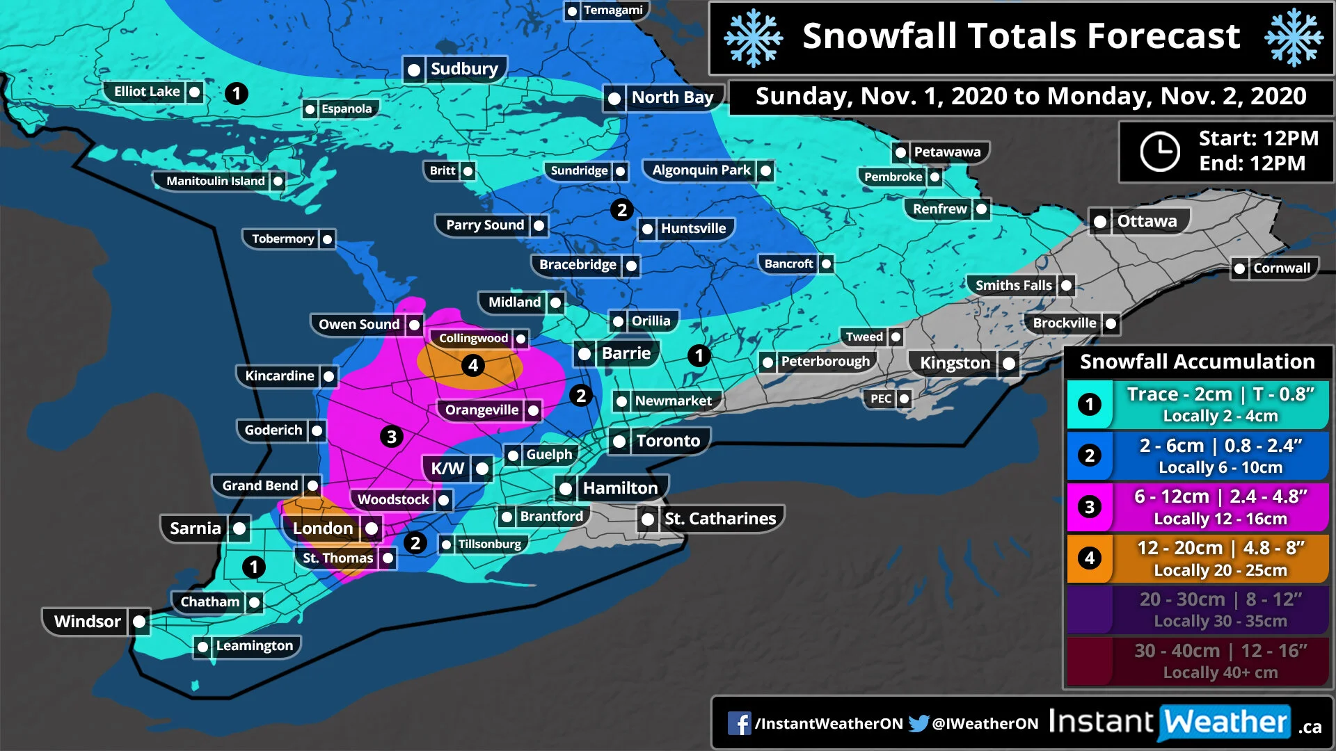
Snowfall totals will vary significantly as is typical with snow squall events with one area seeing extensive accumulation and another just a few kilometres away seeing just scattered flurries. So keep in mind that our forecast is based on the latest model data and where we believe the squalls will set up. A slight change in the wind direction could cause these zones to shift around. With that being said, the heaviest accumulation is expected south of Georgian Bay and southwest of Lake Huron including locations such as Flesherton, Lambton Shore and Strathroy where between 12-20cm of snowfall accumulation is possible. Surrounding regions including London, Hanover, Orangeville and Collingwood could see as much as 6-12cm with local totals pushing 15cm.
You might notice that we have lower totals around the Lake Huron shoreline and this is because we expect temperatures to be slightly warmer hovering near the freezing mark. This means that while they will see just as much snowfall as inland, most of it will melt on contact due to the warmer temperatures. This includes Goderich, Kincardine and Wiarton with snow totals between 2-6cm. All other areas can expect less than 5cm of total snowfall from this event.

We are also expecting a fairly strong wind storm to develop Sunday evening with wind gusts around Georgian Bay and Lake Huron exceeding 90km/h and even approaching 100km/h right along the shoreline (particularly the Grand Bend, Goderich and Kincardine area). Away from the lake, we’ll still see strong winds ranging from 70-85km/h which could bring down some small tree branches and cause localized power outages. This will last overnight into Monday morning with the wind gusts subsiding after sunrise. Now, the strong wind gusts will be occurring at the same time that we expect strong snow squalls to affect some areas through the snowbelts. As a result, blowing snow and near-zero visibility is quite likely in the affected region so be sure to drive according to the conditions especially since this is the first big snowfall of the season.
We’ll continue to monitor the latest data and issue updates as necessary!
