
Flooding rains, Tropical Storm Force Winds & Snow to Start The 1st Week of November!
/Issued on November 1st, 2020 at 8 AM
Updated at 3:30 AM, November 2nd, 2020
Forecaster: Student Meteorologist James Follett

Good Morning! It’s the first of November! only 2 full months left of this crazy terrifying year, and also 2 months until Christmas y’all! in fact, while I was buying some junk food for myself so I can binge Halloween movies much of the night haha. I ended up watching Halloweentown and Hocus Pocus! so anyway, As I was going through the isle I started to see the Christmas candy and foods out! such as candy canes, chocolate liquor & those Christmas day calendars with a piece of chocolate for each day. So it’s coming fast!
I hope you all had a fantastic Halloween and didn’t get sick from all the candy! You’re going to want to enjoy today’s weather because we have a pretty big size storm coming our way that will start off as some heavy flooding rainfall & strong Tropical-storm-force winds. Then as the system pulls away, it is going to usher in some very cold air, and that will change much of the rain to snow, and there could be some ocean effect snow squalls!
We have Flood warnings up for southern portions of Nova Scotia, and Wind warnings for Cape Breton, and I would not be surprised to see wind warnings get expanded to much of the province.

We’ll start off by looking at the FutureCAST taking us out through the next 84 hours, High pressure currently keeping us dry, but very cold inland! will begin to break down and move eastward later today, this will give us some increasing cloudiness as we go into the rest of the day. Your afternoon drive, noon hour rush hour, and as well as the evening rush hour should be dry! It looks like, as of now that the first bands of rain will arrive on the South Shores and Tri-Counties sometime near 8 or 9 O’clock tonight.
The system is a fast mover, so it will not take long for the rain to spread across the province, the heaviest rain will arrive in the Southern parts of the province sometime near midnight and continue into the early morning hours of Monday. Then as the low begins to exit, we will see the rain taper off a little to some showers and light to moderate rain at times and this will continue until noontime, then we will see that cold air mass flow in right after lunchtime. Those are the blue lines you see, which represents the 500mb level, the lower the number in the blue, the colder the airmass so for example if you see 522, that is a polar air mass and that is very cold! 534-540 is the threshold for rain/snow or as we call it the rain/snow line. it’s the dividing line between cold and warm air.
By noontime, we will be 540, which is the start of cold air, however, it will still be warm enough to produce liquid precipitation. But because the colder air is funneling down, we’ll likely see temperatures drop through the day on Monday and the thickness levels drop down to 528mb by afternoon and this is normally the level we start seeing some mixed precipitation or snow however the models want to put it at drizzle/showers and I think it’s a bit underdone on the type of precipitation because at 7 pm Monday night, the model has precipitation falling as some light showers or drizzle and perhaps some light rain in the darkest green. The low will be centered just south of Yarmouth at this timeframe. a thickness level of 528, but when looking at the 850mbT ( Temperatures at 5000ft up) temperatures are going to be around -5 degrees, well cold enough for snow to form in the upper air, and temperatures at the surface will be between 3 and 6 degrees, which is mild.. however, if the air above is cold enough then it can still snow at these mild temperatures, in fact, it can snow even at 10 degrees C at the surface if the upper air temperatures are just cold enough! but it wouldn’t stick to the surface of course, but you would see it fall :)
In this case, with cold enough upper air temperatures and temperatures at the surface just a few degrees above freezing. The above freezing temperatures at the surface are likely why models say rain but I think this would fall as some wet snow! So do not be surprised to see some wet snowflakes around supper time Tomorrow.
Now, by the time we get near midnight Monday into Tuesday morning, you notice how the greens change to blue which represents snow of course. In fact, showing some moderate snowfall over Digby county by midnight. The thickness levels remain near 528, but the surface temperatures are right around 1 degree C, still above freezing but at 850mb or (5000ft) temperatures are now down to a very cold -10 degrees C and this is why the models are showing the change to snow, and I think the models have this pretty good at showing snow near midnight starting near Digby then spreading inland to rest of the province.
Scattered flurries and potential local ocean effect snow squalls continue into Tuesday afternoon as the cold air continues to dive down. in fact, by 10 am Tuesday the thickness levels are at 522! which is a polar airmass, this is an air mass with some very cold air, and so this is why we can expect precipitation to be all snow. It’s going to be a very cold day on Tuesday, so enjoy the last of warmth while you can!
By Wednesday it is back to sunshine, however, the temperatures will remain quite chilly!

Taking a look at the latest Infrared Satellite, MSLP & Fronts. Here is our big storm located over Ontario, it’s very large! it is spreading clouds and precipitation over much of the North Eastern US, and parts of the SE states. We have this large cold front that stretches all the way down to Texas, this cold front is what will usher in cold air for Tomorrow late day and continue into Wednesday, and actually, there is another front behind that one, and that one is what will be the very cold but dry air for Wednesday.

Here are the latest current temperatures and fronts. notice the warm air ahead of the first front under a High pressure? Temperatures in the 50’s and 60’s F. Behind the first front, there is little temperature change but it’s cooler into the 40’s to near 50 F. Then behind the 2nd cold front, and the very large high-pressure zone that is where you will see the coldest air! with temperatures into the 10’s F, which is in the -10’s C. We will be getting a piece of that! coming in here for Tuesday & Wednesday! so starting the month off to a bang and celebrating it with Mr. coldmeiser.

Now, with that big low pressure, there is tightening isobars and the tighter they are the windier it is! and boy is it windy and gonna get even windier over Ontario and great lakes! We have sustained winds in those areas as high at 60 km/h with higher gusts near 100 km/h! and those winds are heading this way for later tonight into Tuesday.

We have several advisories, watches & warnings in place to our south ahead of this storm, as well as do we in terms of wind and flood warnings. There are marine advisories up and down the whole entire eastern seaboard and all of the Southern state’s coastline as far as Texas! We have several winter advisories and wind advisories over the Great lakes, Freeze warnings to the south, and parts of the Northeastern states.
Looking at the current fronts, we have High pressure dominating much of the east coast and a large low pressure over the Great lakes, a cold front that stretches down towards Texas, another cold front behind it that goes into Oklahoma.

Fast forward into 11 am Tomorrow, seeing the fronts not moving much, we have the cold fronts still over the Great Lakes, High pressure moved further away, and pressure falling.

The low deepens and cold front becomes more longer and stronger as we get into the 24 hour period at 11 am Tomorrow morning.
So How much rain are we talking here?


We have the RDPS and ECMWF models of Total Precipitation. The top one, which is the RDPS Canadian model is suggesting that the highest amounts will be on the South Shores, while the Euro model says Digby/Yarmouth area.
As of now, with the storm track and model guidance, it looks like the heaviest rain will be in the entire southern parts of the province, elsewhere there will still be some significant rainfall but not as much as the southern areas.
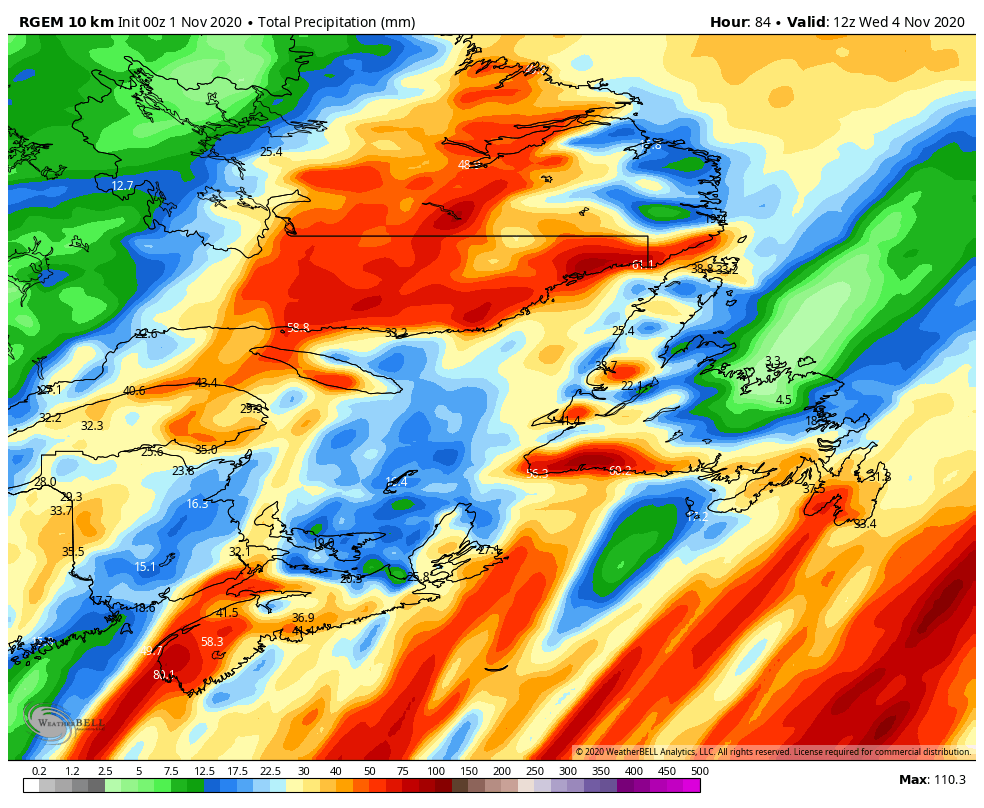

Here is a look at the amounts from the FutureCAST RDPS model, darkest reds are amounts 60-90mm+
Digby, Yarmouth, Shelburne & Queens can expect amounts of 50 to 75 mm, with higher local amounts possible. Instead, this model has 80 mm for Yarmouth through Wednesday. The rest of the province can see 30 to 50 mm, however a few spots looking to see 15 to 25 mm.

Now, the question is how much of the white stuff?? well, here is the good news! not expecting much. Much of the province will see an inch or less, there will be some spotty locations that will likely see some more. Parts of Digby county could see as much as 4” or 10 cm, and Northern & Western CB could see as much as 25 cm! Eastern CB, likely up to 2” or 5cm and much of the Eastern side of the province will see a dusting if anything!

From rain & snow to now winds, which will be the biggest story! because we are going to have many areas get Tropical-storm-force winds and these winds could be damaging. especially after just celebrating Halloween, if you have any decorations, it will be a good day to spend the day bringing them in as they could be at risk of being tossed in the wind. The wind will also cause possible damage to roofs and windows.
Winds will increase through tonight into Tomorrow, with Gusts over much of the province between 80 and 100 km/h, however, there will be some areas who may get above 110 km/h. Newfoundland is gonna get blasted Tomorrow!
Winds will be lightest in Digby & Yarmouth, where winds will likely just Gust to 70 km/h.
Check back here for a further update at 6pm for the latest on the storm and your local & regional forecast!
