
Snow Squall Outbreak to Dump Up to 75cm of Snow on Parts of Southern Ontario This Weekend
/
NOTE: You can click on the map to open a zoomable image which will be easier to read.
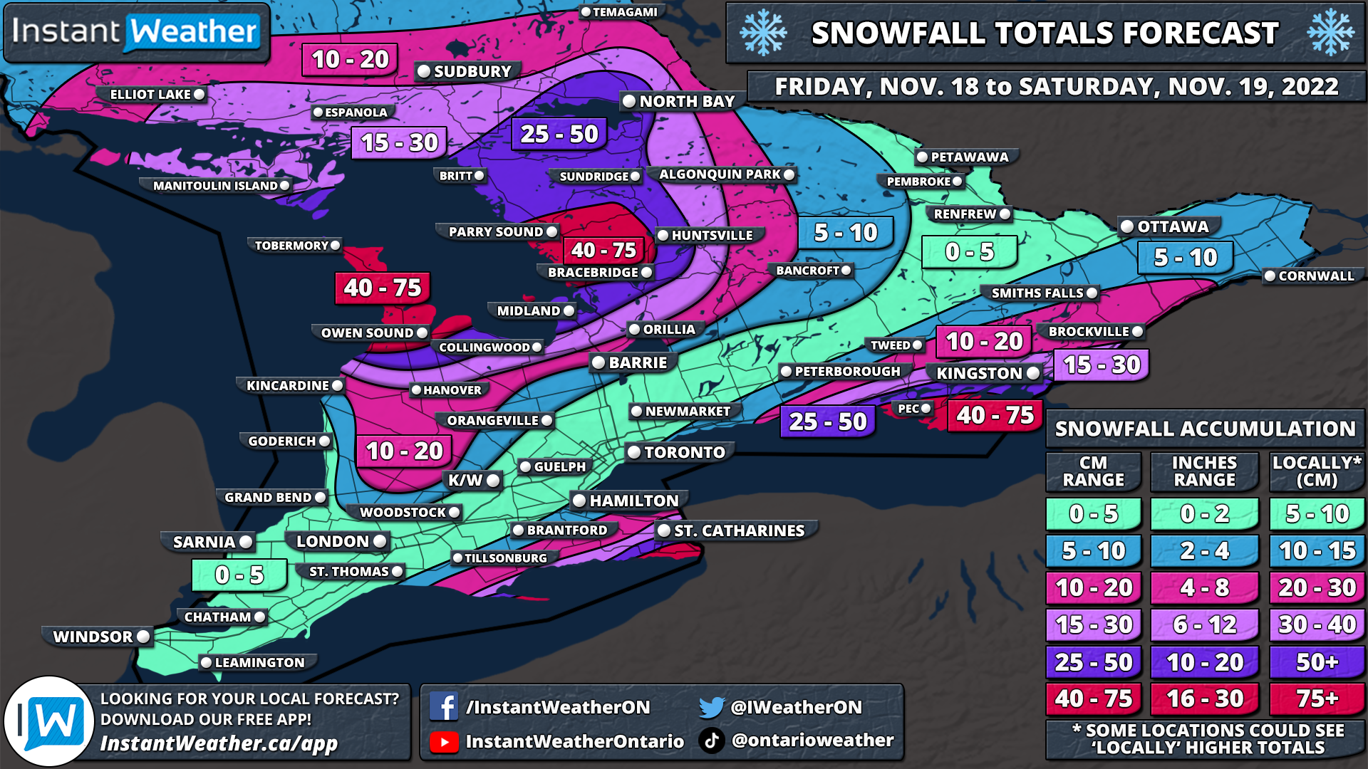
A multi-day snow squall outbreak is currently underway and is expected to linger into the weekend bringing with it very dangerous conditions through parts of the snowbelts. The focus will be on areas to the northeastern shorelines of Georgian Bay, Lake Ontario and Lake Erie where a persistent southwesterly will allow for intense snow squalls to set up over the next 48 hours. Some of the hardest hit regions including Wiarton, Owen Sound, Muskoka, Parry Sound, Fort Erie and Prince Edward County could be looking at locally up to 40-75cm between Friday and Saturday. Combined with strong wind gusts, this will present a dangerous situation out on the roads making travel nearly impossible in the affected regions. Consider postponing any non-essential travel between Friday and Saturday within the hardest-hit area. Blizzard-like conditions can’t be ruled out along with thundersnow as we saw in some areas throughout the overnight hours.
Lake effect snow will continue to linger throughout the morning and into this afternoon, however, it will be fairly disorganized and shouldn’t lead to significant accumulation. The main activity is south of the border through the Buffalo and Watertown regions which are expecting a heavy dumping of snow with up to 100-150cm by the end of the weekend! More organized snow squalls will develop off Georgian Bay late Friday as the wind direction shifts to a predominantly southwesterly flow. These squalls will stretch across the Bruce Peninsula and over Georgian Bay before coming inland somewhere around Parry Sound and Port Carling. Expect very hazardous conditions along Hwy 400 and 11 east of Georgian Bay starting early Saturday morning and continuing throughout the day.
The intense squalls affecting regions northeast of Lake Erie and Lake Ontario will slowly shift to the north overnight and into Saturday morning. As a result, we expect to see rapid snowfall accumulation through parts of the Niagara and Kingston/Prince Edward County regions along with reduced visibility making for poor driving conditions. Current indications suggest that the bands will break apart by the late afternoon or early evening hours, but this will only be temporary as the wind direction shifts around. A few more hours of heavy snow is possible overnight as a system moves through the region and is enhanced by the lakes.
Snow squalls could redevelop on Sunday, but it looks like a more southwesterly flow which would affect areas east of Lake Huron and southeast of Georgian Bay. More details on the potential Sunday squalls will be included in a separate forecast to be posted on Saturday.
Here is an advertisement so we can pay the bills:

NOTE: You can click on the map to open a zoomable image which will be easier to read.
The hardest hit regions in terms of accumulation will encompass the Bruce Peninsula including Wiarton and Owen Sound along with Parry Sound, Port Carling and Rosseau. Accumulation here is expected to top at around 40-75cm over the next two days, however, it’s important to note that the totals will be highly variant and not everyone will see extreme totals up to 75cm. It all depends on where the band sets up and if it locks into any particular region which if it does, could result in even locally more than 75cm of accumulation.
The rest of the northeasterly shoreline of Georgian Bay in addition to regions further inland including Midland, Bracebridge, Huntsville and North Bay will see around 25-50cm which again will be extremely dependent on your location. Accumulation will drop off quite fast further south and east you go with Simcoe County picking up between 10-25cm depending on the location.

NOTE: You can click on the map to open a zoomable image which will be easier to read.
For the snow squalls of Lake Erie and Lake Ontario, the biggest impact will be felt south of the border as mentioned above, but that doesn’t mean we are entirely off the hook. A very localized pocket that includes the southeastern tip of the Niagara region such as Port Colborne and Fort Erie will face the brunt of the Lake Erie snow squall on our side of the border. They could see as much as 40-75cm of snow by the end of the weekend. This is also the case for Prince Edward County which will see lake effect snow off Lake Huron.
The accumulation gradient with these bands will be quite tight so totals will quickly diminish to the northwest. We are looking at around 25-50cm for locations such as Welland, Brighton, Napanee and Kingston. Slightly lower totals are expected for St. Catharines, Niagara Falls and Belleville with accumulation ranging from 15-30cm. For the GTA, impacts will be fairly minimal, but the Hamilton region could see up to 5-10cm thanks to that Lake Erie band briefly pushing through during the afternoon on Saturday.
Here is another advertisement so we can pay other bills:
