
Significant Snow Squalls Continue Into Sunday Around Lake Huron and Georgian Bay With Up to 25-50cm of Additional Accumulation
/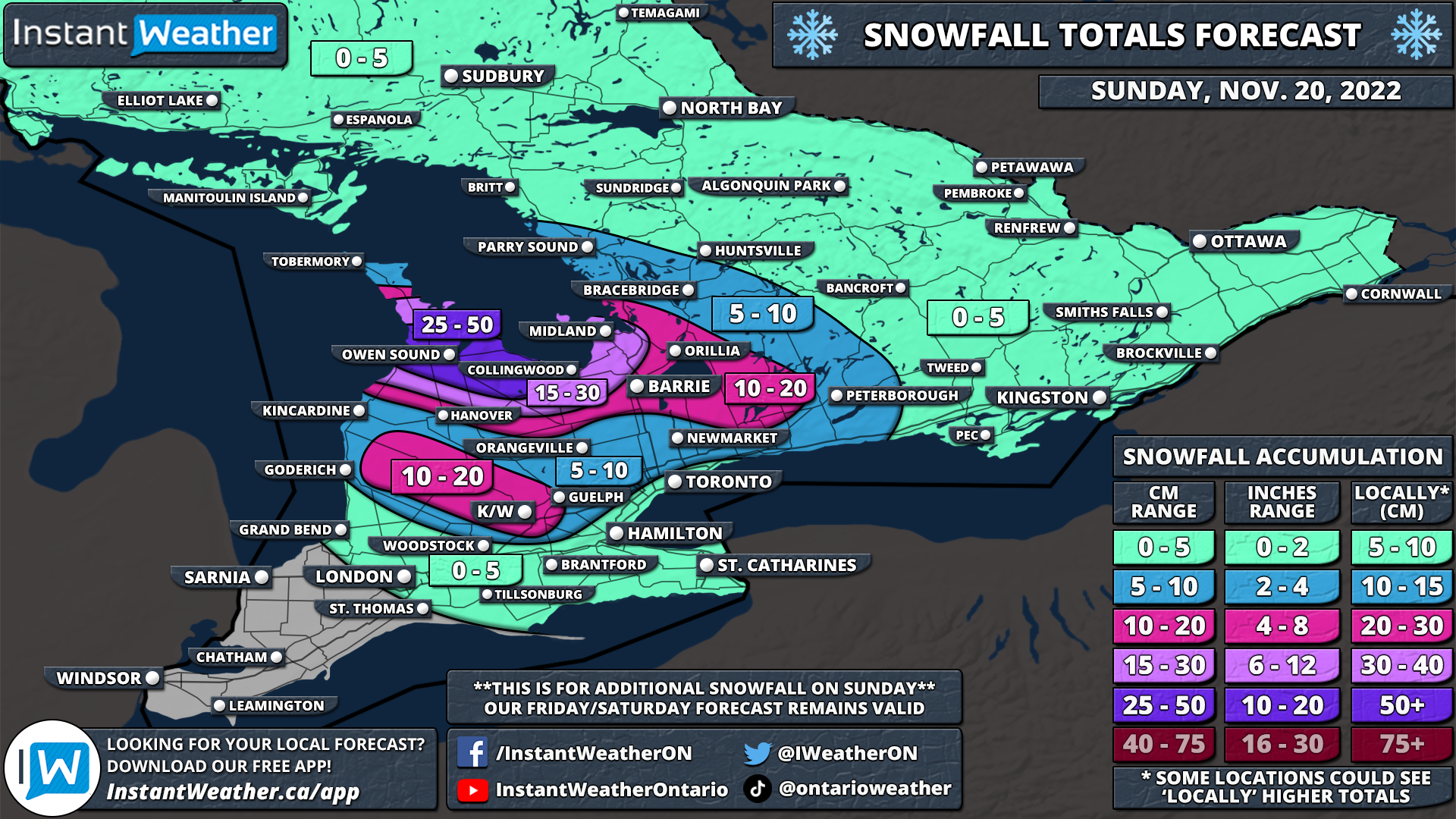
NOTE: You can click on the map to open a zoomable image which will be easier to read.
It has been quite the eventful past 48 hours across parts of Southern Ontario as we have experienced the first major lake effect snow event of the season. Strong southwesterly winds have resulted in the formation of persistent and intense squalls off Lake Huron, Georgian Bay, Lake Ontario and Lake Erie over the last few days. This has meant that some locations not traditionally used to facing the brunt of these squalls including the Niagara region and the Kingston/Brockville area have seen the worst impacts. Although we certainly have gotten off easy compared to our neighbours south of the border with some locations in upstate New York including Buffalo and Watertown being buried in up to 100-200cm since Thursday!
Snow squalls continue to affect those regions this afternoon with rapid snowfall accumulation and near-zero visibility out on the roads. The lake effect activity is expected to continue into Sunday, but the focus will turn towards the southeastern shoreline around Georgian Bay and the Grey-Bruce region. These squalls will become more disorganized throughout the evening as we see a change in the wind direction from southwesterly to more of a northwesterly flow. This will allow for the squalls to reorganize overnight and early Sunday morning with the main squalls stretching across Grey-Bruce and over Georgian Bay before coming inland again throughout the Simcoe County region. Strong wind gusts ranging from 40-70km/h on Sunday will likely cause blowing snow and reduced visibility.
The localized intense band of snow could stretch inland quite far and affect areas as east as Kawartha Lakes and Peterborough. There is even a chance that it could stretch from Georgian Bay to the Lake Ontario shoreline around the Cobourg region. We expect the worst conditions will be primarily during the morning and early afternoon on Sunday. A secondary band might develop off Lake Huron from Goderich and into the K/W region, but it won’t be as intense as the squall further to the north. Regardless, both squalls could bring very poor driving conditions throughout the affected regions so consider avoiding any non-essential travel on Sunday. Organized lake effect snow will come to an end around the dinner hour, but scattered flurries may linger throughout the evening and into the overnight.
Here is an advertisement so we can pay the bills:

NOTE: You can click on the map to open a zoomable image which will be easier to read.
Those in the Owen Sound region won’t be catching a break as they’re yet again expecting to see some of the highest snowfall totals on Sunday along with Chatsworth, Wiarton and Meaford. They can expect an additional 25-50cm on top of what they’ve already seen over the past few days. The rest of the southern shoreline of Georgian Bay including Collingwood, Midland and Wasaga Beach is looking at an additional 15-30cm of snow.
Those further inland including Barrie, Orillia, Northern York Region and the Kawartha Lakes will see around 10-20cm although that depends on the exact placement of the squalls and some may see barely anything. To the south, the secondary band affecting the Wingham, Listowel and K/W area will put down around 10-20cm of snow. Less than 10cm is expected outside of the traditional snowbelts as shown on the map.
Here is another advertisement so we can pay other bills:
