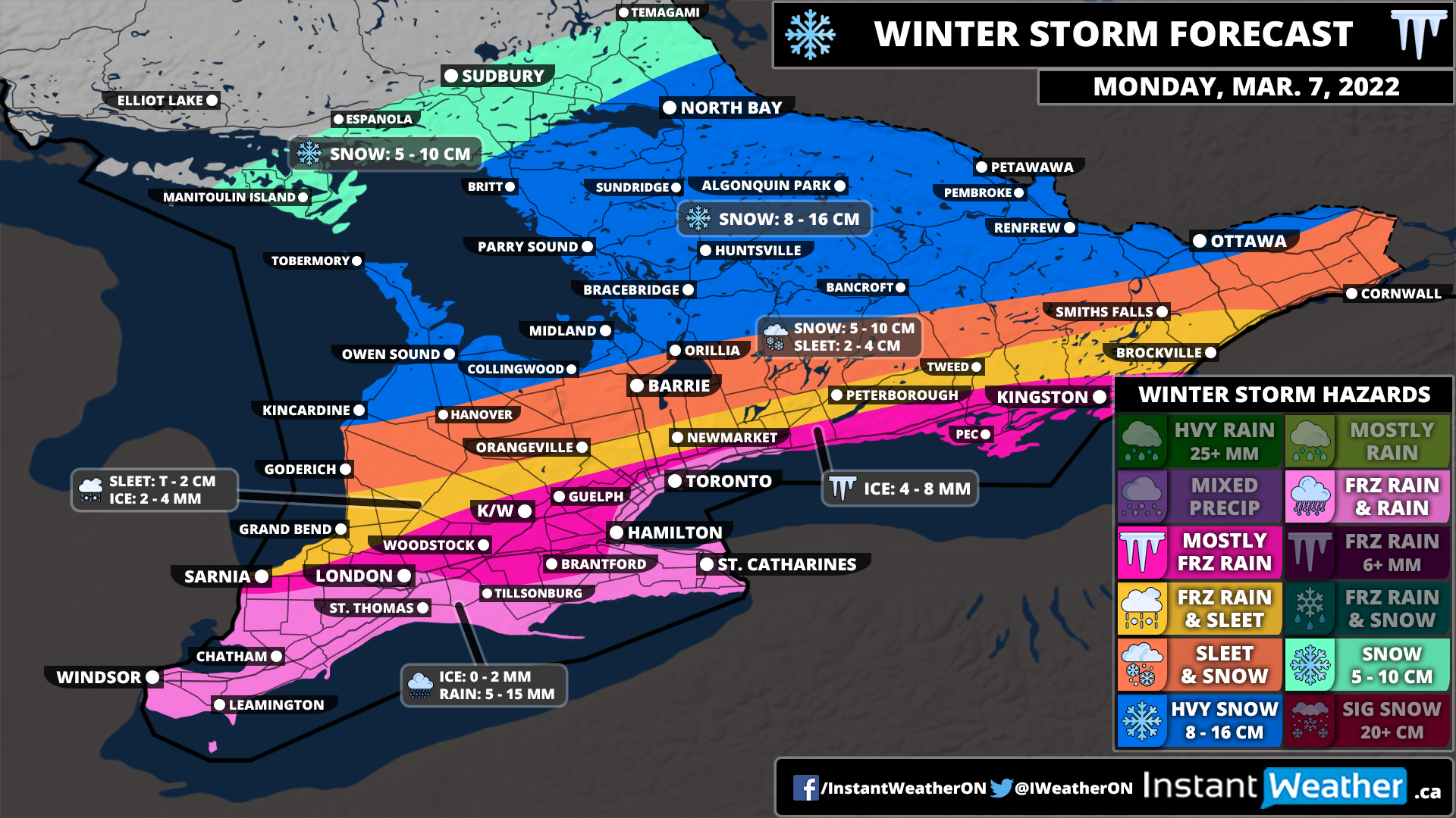
Southern Ontario: Winter Storm Outlook for Monday, March 7, 2022
/Forecast Discussion
After a quick taste of spring-like weather across Southern Ontario on Sunday, we are expecting the return of wintery weather throughout the day on Monday. This is courtesy of a messy system set to bring a wide range of precipitation with heavy snow through much of Central Ontario and into the Ottawa Valley. Further south, the concern will be a fairly prolonged period of freezing rain for London, K/W, Guelph, GTA (away from the shoreline) and into the Kingston area. Those in Deep Southwestern Ontario and the Niagara region should see minimal impact from this storm as we expect temperatures will remain just above the freezing mark throughout the event.
The precipitation associated with this system will start to move into the region from the southwest during the mid to late morning hours on Monday. This includes a band of freezing rain stretching along the Hwy 401 corridor from London to Northwestern GTA at the height of the morning commute so if you have to travel, make sure to leave plenty of time and drive according to the conditions. It appears that locations through the GTA that are right along the lakeshore should stay just warm enough to avoid the freezing rain. This includes Hamilton, Burlington, Mississauga and Downtown Toronto. However, it’s right on the line and if temperatures end up just a degree or two colder then they could also see the freezing rain. We have more confidence in the Niagara region and along the Lake Erie shoreline which should stay predominantly rain with maybe a brief round of freezing rain (less than an hour).
Precipitation will spread further to the north as it encounters colder air around Lake Simcoe and into Eastern Ontario. As a result, the main precipitation type will be ice pellets with some freezing rain in the south and snow to the north mixing in at times. This includes Goderich, Orangeville, Barrie and Cornwall. The ice pellet mix will linger into the afternoon before clearly late Monday from west to east. Total snowfall accumulation here is a little more uncertain depending on exactly how prevalent ice pellets are with this storm. Right now, we’re going with a general 5-10cm, but the potential for slightly below or above the forecasted totals can’t be ruled out. For Grand Bend, Newmarket and Peterborough they could see a few hours of freezing rain in addition to the ice pellets.
A band of moderate to heavy snowfall from this system will stretch from Grey-Bruce through Muskoka and into the Ottawa Valley starting late Monday morning and continuing into the afternoon. The colder air will hold on here so we are expecting little to no mixing except maybe some ice pellets. Total snowfall accumulation will range from 8-16cm by the end of Monday. The snow will taper off by the evening or closer to midnight for Eastern Ontario. Colder air will flow in behind the system as it moves out by Monday late afternoon so don’t be surprised to see some light snow throughout Southern Ontario outside of the snow zone on our map. But accumulation should be minor as the snow will be quite wet and surfaces will still be wet from the earlier rainfall.
We could see some icy road conditions as temperatures drop well below the freezing mark overnight Monday. This may also further enhance the impact of the earlier freezing rain accretion as it won’t have a chance to melt in some locations before the cooldown occurs. Power outages even into Tuesday aren’t out of the question as tree branches and power lines break under the stress of the ice accretion. Thankfully we only expect 8mm of ice accretion at most from this system so overall impacts shouldn’t be too significant.


