Another Stormy Day

Valid: Thurs Feb 3 - Fri Feb 4

Another Stormy Day

What is interesting about this storm is that it is not on the weekend. Other than that, PEI is in the path for a large blast of winter weather starting on Friday. We will be looking at significant snow, and some areas of the province will be looking at ice pellets. With the current path, areas around Wood Islands could see some freezing rain late Friday night.

TIMING:

Current models are indicating that on Thursday, during the day, across PEI we will see some rain. The system starts to arrive in PEI just after midnight in the early morning hours of Friday. It will snow heavy during the daylight hours and the majority of the snow will be down by Friday evening. There will continue to be lingering flurries through the day Saturday giving us an additional 2-5cm.

Throughout the storm, especially during the early morning hours of Friday, we can expect to see ice pellets in Kings and parts of Queens County. This will be mixing in with the snow.

TOTAL AMOUNTS ACROSS THE PROVINCE:

The below accumulations are what we can expect to see on Friday:

SNOWFALL

Prince County – 30-40 cm

Queens County – 30-40 cm

Kings County – 30-40 cm (areas from Stratford to Georgetown to the North Shore and East Point)

Kings County - 20-30 cm (areas from Stratford to Georgetown to Wood Islands)

WIND: Winds will not be as large of a factor with this system, however, they will still be significant enough to blow the snow around causing some white out conditions. Overall, winds should be 40-60 km/h from the north. Saturday will see the winds continue in the 40-60 km/h range.

TEMPERATURE: Thursday we will see temperatures just above the freezing mark in the 3-5 C range. They will begin to drop later in the evening on Thursday and from the early morning hours of Friday through to Saturday morning temperatures should be around the -3 to -5 C range. By noon on Saturday, temperatures will begin to drop and by evening we could see them dipping to -10 to -15 C. Sunday could see temperatures dipping even further to -15 to -20 C.

Any shift in the front could greatly vary the precipitation types and quantities. We will continue to monitor this system and keep you updated with any significant changes.

The significant snowfall, combined with the consistent winds and the already high snowbanks along the roadways will cause white out and hazardous driving conditions during Friday and into Saturday. Please stay home unless absolutely necessary. Always adhere to the recommendations of the RCMP and PEI Public Safety.

As always, be safe and let us know what you are experiencing in your areas.

Storm chip Probability: 100% (again)

IWPE Team (Mike S, Harry S)

Another Weekend, Another Winter Storm

Valid: SAT, JAN 29, 2022

What comes after 5 days of work???? A winter storm. PEI is in the bullseye for yet another large blast of winter weather and once again, it is on a Saturday. We will be looking at significant snow, and some areas of the province will be looking at ice pellets, freezing rain and rain on the tail end of the system.

TIMING:

Friday night into early Saturday morning, we will see a light dusting across the province. The ‘real’ system starts impacting the entire province shortly after daybreak on Saturday. The heaviest bands of snow will arrive during the afternoon hours and by evening, the majority of the snow from this system will be down across the Island.

We should see a brief change over from snow to sleet in the evening on Saturday and Queens county could also see a little bit of freezing rain. Kings County can expect to see the snow change over to sleet and then to rain by early evening, and the rain may push across to Queens and Prince counties briefly around midnight Saturday.

TOTAL AMOUNTS ACROSS THE PROVINCE:

The below accumulations are what we can expect to see on Saturday:

SNOWFALL

Prince County – 20-30 cm (higher accumulations closer to Queens County)

Queens County – 30-40 cm

Kings County – 20-30 cm (areas around Wood Island may only see 15-20cm)

RAINFALL

Prince County – 1-5mm

Queens County – 1-5 mm

Kings County – 5-10mm

WIND: Winds will be a factor with this system. It is a fairly fast moving system and what that means is the higher wind gusts will be over a shorter period of time. Winds will be from the North / Northeast and will gradually increase throughout Saturday morning and should start diminishing late Saturday night. The stronger winds will occur between 2pm and 8pm Saturday. Overall, wind should be 40-60 km/h with gusts of 70-90 km/h during the late afternoon hours. Prince County could see some wind gusts reaching close to 100km/h near supper time on Saturday.

TEMPERATURE: We should be starting the day on Saturday with temperatures around the -5 to -10 C range and as the day progresses we will see those temperatures rise above freezing to around 2-4 C by Saturday evening and then temperatures will again decrease to -5 to -10 C area by noon time on Sunday.

Any shift in the front could vary the precipitation types and quantities. We will continue to monitor this system and keep you updated with any significant changes.

Winds and snow will cause white out and hazardous driving conditions during Saturday. Be prepared for power outages. Please exercise caution if you are on the roads. Please stay home unless absolutely necessary. Stranded vehicles are a hazard to those in them as well as emergency and road crews. If you do not need to drive, stay home and eat chips. Always adhere to the recommendations of the RCMP and PEI Public Safety.

As always, be safe and let us know what you are experiencing in your areas.

Storm chip Probability: 100%

IWPE Team (Mike S, Harry S)

Another Winter Storm Heading for PEI

Valid 14 Jan, 2022

…and just like that, our second winter storm of 2022 is heading our way. This one has a number of the same characteristics of last week's storm - significant snow and high winds.

TIMING:

Prince County should see this as a snow event only with the snow starting late afternoon on Friday. Kings County, and possibly most of Queens County will see this system start as rain around lunch time on Friday. By early evening that rain will have a change over to snow in Queens County. We may see some ice pellets in Queens County during that changeover. In Kings County, the changeover will see ice pellets and possibly see some freezing rain. By 10pm, it should be an all snow event. Snow will continue through the overnight into Saturday and will diminish to flurries some time Saturday afternoon.

TOTAL AMOUNTS ACROSS THE PROVINCE:

The below snowfall accumulations are what we can expect to see from Friday evening to Saturday afternoon:
SNOWFALL

Prince County – 30-40 cm
Queens County – 30-40 cm
Kings County – 20-30 cm

WIND: Again, winds will be a factor with this system. Winds will be from the North / Northwest and will gradually increase through the evening hours of Friday and should start diminishing Saturday around noon. The stronger winds will occur between 2am and 10am Saturday. Overall, wind should be 50-70 km/h with gusts of 80-100 km/h n

TEMPERATURE: Friday will start with temperatures hovering around the freezing mark and by supper time Friday, temperatures will begin to go down and will reach lows near -10 by Saturday evening.

Any shift in the front could vary the precipitation types and quantities. We will continue to monitor this system and keep you updated with any significant changes.

Winds and snow will cause white out and hazardous driving conditions. Be prepared for power outages. Please exercise caution if you are on the roads. Saturday will be a day that travel is not recommended. If you do not need to drive, stay home and eat chips. Always adhere to the recommendations of the RCMP and PEI Public Safety.

As always, be safe and let us know what you are experiencing in your areas.

Storm chip Probability: 100%

IWPE Team (Mike S, Harry S)

Another Blast of Winter

Valid Feb 7, 2021

It looks like Mother Nature has something planned for the Superbowl after party.

TIMING:

Snow will begin sometime after 8pm and will quickly make its way across the entire province. It will continue to snow throughout the night with it tapering to flurries on Monday near noon.

TOTAL AMOUNTS ACROSS THE PROVINCE:

Once again, the models do not totally agree on this system and any slight shift in the low could change the predicted snowfall accumulations below.

Prince County – 5-15 cm

Queens County – 10-20 cm

Kings County – 20-30 cm

WIND: Winds will be a factor with this system. Many areas of the Province will experience blowing and drifting snow.

Wind will start increasing near midnight Sunday night and continue until late Monday. Wind will be 30-40 km/h with gusts of 50-60 km/h early Monday into mid day with higher wind gusts in Kings County possible.

TEMPERATURE: Temperatures will drop throughout the day Monday. Starting the day around -2 to -4C and ending the day around -7 to -10C.

With the increasing winds and snow, visibility will be diminished, mostly in Kings and Queens counties. Please exercise caution on the roads throughout the evening hours of Tuesday.

Snowfall or Blizzard warnings may still be issued as the storm system moves closer to the Province.

As always, be safe and let us know what you are experiencing in your areas.

Storm chip Probability: 100% (only because you should have them on hand for the Superbowl).

PEIBW Team (Mike S, Harry S)

Wintry Blast to Hit PEI

Valid: Monday Feb 1, 2021

Wintry Blast to hit PEI

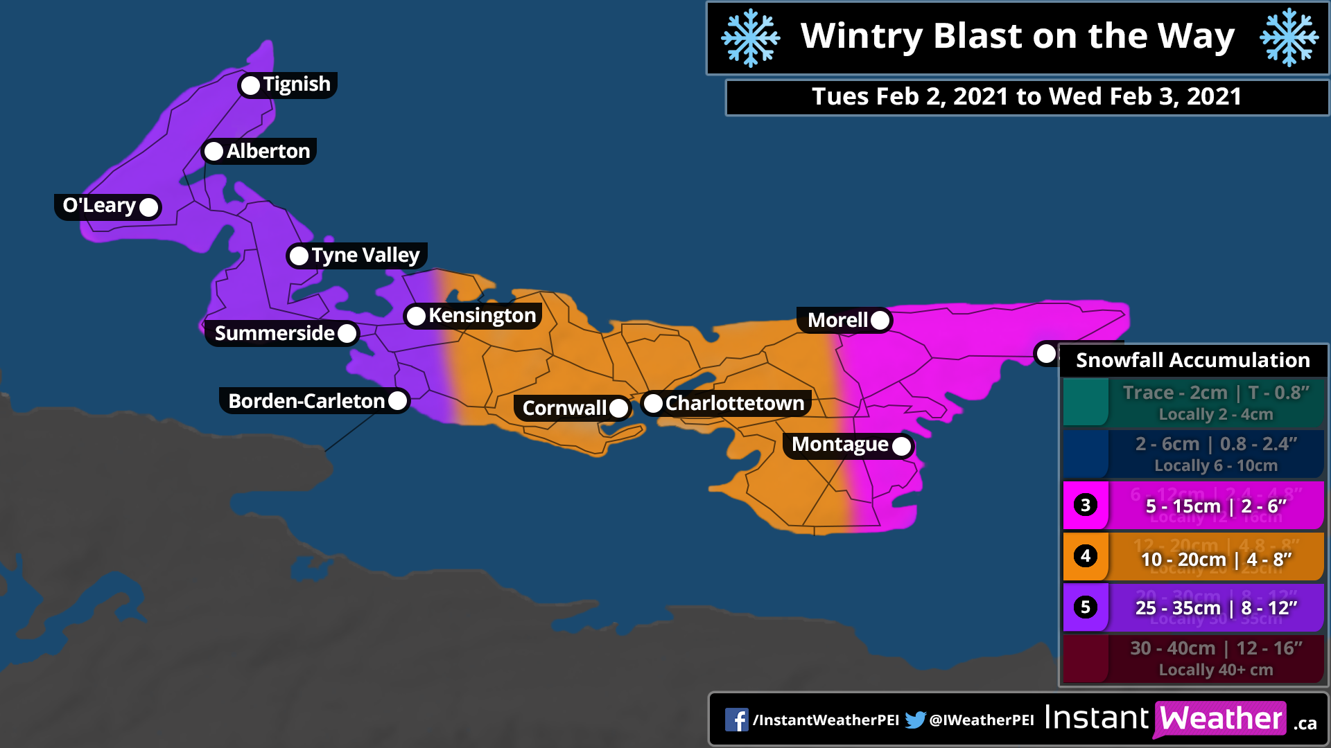
The one thing we know for sure is that the system we will see on Tuesday afternoon into Wednesday morning is going to be a messy one.

TIMING:

Snow will begin around noon on Tuesday across the Island and should be all down by early evening. This is where the mess begins. Snow will change over to ice pellets around 5-6 pm and some areas around Kensington may see some freezing rain for a brief period during the change over. Rain will quickly set in across the province in the early evening and will continue until Wednesday morning.

TOTAL AMOUNTS ACROSS THE PROVINCE:

The models are still not in total agreement, but what we can see at this time is the following accumulation amounts. Higher snow accumulation areas will be in Prince County.

Snow

Prince County – 25-35 cm

Queens County – 10-20 cm

Kings County – 5-15 cm

Ice Pellets

Prince County – 1 cm

Queens County – 1 cm

Kings County – 1-2 cm

Rain

Prince County – 15-20 mm

Queens County – 15-20 mm

Kings County – 20-25 mm

WIND: Winds will be a factor with this system. Many areas of the Province will experience blowing and drifting snow.

Wind will start increasing early afternoon on Tuesday and diminish overnight into Wednesday morning. Mid afternoon when the snow is coming down, the province should see winds of 40-50 km/h. Wind gusts of 70-90 km/h can be expected in the late evening hours of Tuesday until just after midnight.

TEMPERATURE: We will start the day across the province at around -5 to -7 C. We will see a gradual warming across the province from East to West starting mid afternoon and by early evening hours the entire province should be experiencing temperatures around +2 C. The warmup will continue overnight and by Wednesday morning we could be waking up to temperatures near +5 to +7 C.

With the increasing winds and snow, visibility will be diminished in areas during the mid afternoon to suppertime area. Please exercise caution on the roads throughout the evening hours of Tuesday.

If you want to clear your driveways and sidewalks, you are going to want to get that done before the rain starts in the early evening (around 8pm).

As always, be safe and let us know what you are experiencing in your areas.

Storm chip Probability: 40%

PEIBW Team (Mike S, Harry S)

First Snowfall of 2021 Is on the Way

Valid: Saturday Jan 2, 2021 to Sunday Jan 3, 2021

Snow is coming

There is not going to be a lot of snow coming, but there will be enough in areas of the province that you will need your shovels and possibly snow blower to clear the driveway.

TIMING:

Snow will begin around noon on Saturday and will continue just past midnight into Sunday morning.

TOTAL AMOUNTS ACROSS THE PROVINCE:

The models are still not in total agreement, but what we can see at this time is the following accumulation amounts.  Higher accumulation areas will be the south side of the Province:

Prince County – 5-10 cm 

Queens County – 10-15 cm 

Kings County – (Morell to Georgetown to East Point) 5-10cm

Kings County - (Morell to Georgetown to Wood Islands) 15-20 cm  

WIND:  Winds will not be a large factor with this system, however there may be areas of the Province that will experience blowing and drifting snow.

Wind speeds will be at their highest Saturday evening but will only be 30-40kmh with gusts reaching 40-60kmh. 

TEMPERATURE:   Temperatures will be around -7 Saturday morning and gradually warming to near the freezing mark Saturday night into Sunday morning. 

With the increasing winds and snow, visibility will be diminished in areas. Please exercise caution on the roads throughout the evening hours of Saturday.

As always, be safe and let us know what you are experiencing in your areas. 

Storm chip Probability:  10% 

PEIBW Team (Mike S, Harry S)

Teddy Paying a Visit to PEI

Valid: Tuesday September 22 to Wednesday September 23, 2020

119715892_702893467327800_7717816637776709119_n.png

Well good evening Prince Edward Island. As many of you are aware, Teddy is going to pay a visit to our Island on Tuesday and Wednesday. There has been a lot of speculation as to the impact this will have on the Island and we will do our best to let you know what we are seeing.

The track of the system a couple of days ago was trending off the east coast of Cape Breton. The latest model runs seem to have the centre of the low staying east of PEI.

This system will start on Tuesday mid day and we will see it finally move out of the region Thursday early morning. Here is what the models are currently indicating:

WINDS

The winds will start to increase after noon on Tuesday.

Across the Island we will see sustained winds of 40-60 kmh with gusts up to 70-90 kmh. The higher wind gusts will be after supper into the evening. Winds will diminish after midnight.

Wednesday:

Winds will again start to pick up mid morning and we will see sustained winds of 40-60 kmh with gusts again in the 70-90 kmh range. Winds from the system will remain high until around midnight on Wednesday night before we start seeing them diminish and move out of the region totally by noon on Thursday.

RAINFALL

Total rain accumulations with this system are approximated to be:

Tuesday:

Prince County: 15-25mm

Queens County: 25-35mm

Kings County: 35-45mm

Wednesday:

Prince County: 15-25mm

Queens County: 25-35mm

Kings County: 35-45mm

With the foliage still out, the rain and the winds may cause trees to be uprooted. Please heed the warnings of all safety personnel. Ensure you have your emergency preparedness kit ready should you experience a power outage. It is quite likely that power outages may occur across the region.

Please be safe and let us know what you are experiencing in your area.

We will update you as the system moves across the island and if anything significantly changes.

Storm Chip Probability: 95%

Thanks and stay safe.

IWPE: Harry and Mike