Wintery Blast To Bring Northern Ontario’s First Significant Snowfall Between Wednesday and Friday With Up to 50cm of Accumulation Possible

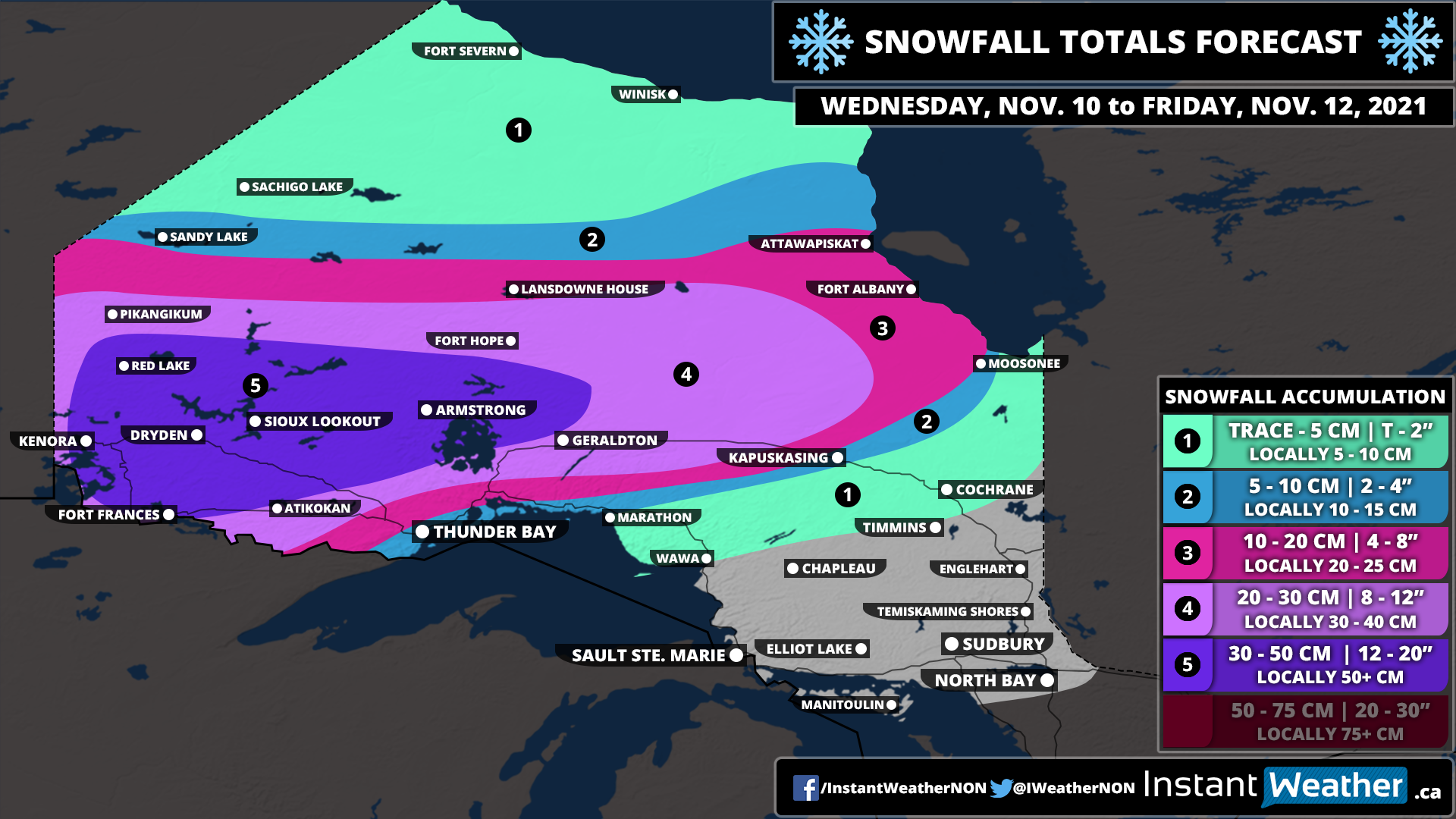
A potential major snowstorm is on the horizon for parts of Northwestern Ontario over the next day as a strengthening low-pressure system stalls out and pumps moisture from the Gulf of Mexico into the region. This combined with a push of cold Arctic air will allow from rapidly accumulating snowfall starting late Wednesday, continuing through Thursday and lingering into Friday. The heavy snow will also be accompanied by some very strong wind gusts which will result in blowing snow and near whiteout conditions out on the roads.

Conditions will begin to deteriorate starting Wednesday evening as the first bands of snowfall enter the region from Manitoba and Minnesota and slowly spread to the north and east throughout the overnight hours. The worst conditions will be found during the day on Thursday when the snow will be at its heaviest in addition to the wind starting to pick up. Travel will likely be near impossible on Thursday through the Kenora, Dryden, Sioux Lookout and Armstrong area and we may even see some highways closures. This will continue overnight and into Friday will very rapid snowfall accumulation still occurring for much of the day on Friday too. We will finally see the system move out of the region by late Friday, but some snow may still continue especially near the Quebec border and around James Bay.

For accumulation, we’re looking at a maximum of around 30-50cm with locally in excess of 50cm. This zone includes the Kenora, Dryden, Sioux Lookout, Fort Frances and Armstrong areas. Other locations such as Atikokan, Geraldton and Fort Hope will see slightly lower amounts topping out at between 20-30cm. As for Thunder Bay, they’re right on the mixing line and may see some rain mix into the wet flurries which will help stop much accumulation from occurring. Right now we’re saying 5-10cm although this may change depending on the track of the system.

First Snowstorm of the Season Takes Aim at Saskatchewan and Manitoba With Up to 30cm of Snow Between Wednesday and Friday

A slow-moving system currently developing over Alberta is expected to bring a wintery blast of heavy snow beginning early Wednesday morning through Central Saskatchewan around Meadow Lake. This band of snow will slowly spread to the southeast towards the Yorkton region by late Wednesday morning and start to affect parts of Southern Manitoba during the day on Wednesday.

There was some uncertainty regarding precipitation type particularly through Southern Manitoba although the latest data appears to point towards a colder solution which would allow for more snow instead of rain mixing in and decreasing accumulation. As such, Winnipeg and most areas except for right along the International border will see predominately snow (likely in the form of heavy wet snow) with accumulation occurring later in the day as temperatures drop further below the freezing mark. Keep in mind that this event is still heavily temperature-dependent and a few degrees can make the difference between a few slushy centimetres and 20+cm of snow.

Snow will continue overnight into Thursday as the low-pressure system responsible for this snow stalls our and bands of precipitation wraps back in through Saskatchewan and Manitoba all day on Thursday. We will start to see some clearing later on Thursday for Saskatchewan with it lingering into early Friday for Southern Manitoba. All of the snow should be finished by Friday morning across the region except for some scattered flurries across Southwestern Manitoba.

As for accumulation, this is really tricky due to the issue with temperatures which can be hard to predict with melting. Although our target zone for the heaviest snowfall includes parts of Southeastern Saskatchewan around Yorkton and extending into Southern Manitoba around the higher elevations for Dauphin and the Interlakes region. This area can expect between 20-30cm of accumulation, but some models are pointing towards as much as 40-50cm of accumulation in localized areas mainly around Dauphin. The rest of Southern Manitoba including Winnipeg and Brandon extending through Central Saskatchewan will generally see between 10-20cm of accumulation over the next three days with most of the accumulation coming on Thursday.

Southern Ontario: Fall Weather Hazards Outlook for Thursday, November 4, 2021

Forecast Discussion

Lake effect flurries are yet again expected throughout the morning and into the afternoon on Thursday around Georgian Bay and Lake Huron. Unlike Wednesday, the wind direction will be changing throughout the day and it shouldn’t be particularly focused on a location so we won’t see any significant accumulation. There will still be some minor accumulation in some areas up to 2-4cm (maybe as much as 5cm) and even parts of the GTA may see the first flakes of the season. The lake effect activity will finally come to an end late Thursday.

Southern Ontario: Fall Weather Hazards Outlook for Wednesday, November 3, 2021

Forecast Discussion

Lake effect activity will continue off Lake Huron and Georgian Bay overnight and into Wednesday. The wind direction will change to a more northwesterly direction which will bring the bands of flurries/wet snow to areas southeast of the lakes instead of the eastern regions that have been mainly affected during the day on Tuesday. Some areas that may see the first flakes of the season include Barrie, London and Brantford. Although significant accumulation isn’t expected at this time with at most 5cm of slushy accumulation. Be sure to drive according to the conditions as this is the first time many has had to drive in winter conditions since last spring.

Southern Ontario: Fall Weather Hazards Outlook for Wednesday, November 3, 2021

Forecast Discussion

Lake effect showers with wet flurries mixed in will continue to affect regions around Lake Huron and Georgian Bay into Wednesday. Although it is currently unclear how widespread the risk of flurries will be so we’ll be waiting until Tuesday evening to issue an outlook for the snow. Although any accumulation will be under 5cm.