Multi-Day Snowfall Event Across Southeastern Saskatchewan Late Tuesday Could Dump 25cm+ of Snow by the End of the Week

NOTE: You can click on the map to open a zoomable image which will be easier to read.

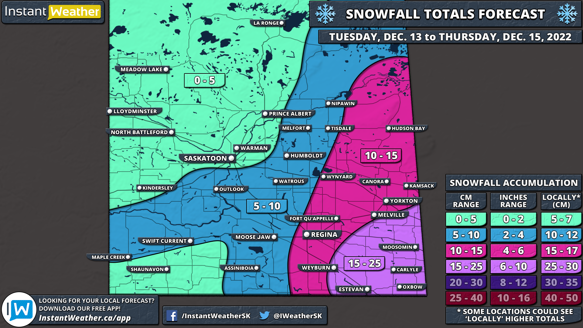
While the winter has started off on a slow note across Saskatchewan, that is about to change this week with a Colorado Low tracking through the province starting Tuesday evening. This will set the stage for a multi-day snowfall event as multiple rounds of precipitation affect mainly southeastern Saskatchewan between Wednesday and Friday. By the time the system moves out on Friday, we expect that total snowfall accumulation could range from 5 to 25cm+ in the hardest-hit locations.

The first effects of the Colorado Low are being felt Tuesday evening as the initial band of precipitation crosses across the North Dakota border and into Southwestern Manitoba. As a result, the worst conditions will be found in locations such as Oxbow, Estevan, Carlyle and Moosomin with the heaviest snowfall rates. By midnight, the moderate to heavy snowfall will have spread to much of southeastern Saskatchewan with the heaviest snow along the international border. Snow will continue overnight and into Wednesday morning although it will become more scattered later in the morning. Flurries and light snow will linger throughout the day on Wednesday and pick up in intensity towards the late afternoon and evening.


Here is an advertisement so we can pay the bills:


Overnight Wednesday, steady snow is expected to affect regions along the Manitoba border into early Thursday morning before tapering off by sunrise. Another round of snow will move in during the afternoon on Thursday, slowly tracking to the west. The overnight hours on Thursday will be dominated by steady light snowfall continuing into the early part of Friday before the system responsible for this snowy weather finally moves out by the end of Friday.

Moving to the western part of the province, it’s possible that snowfall could be quite isolated so not everyone highlight will see snowfall and areas in the 5-10cm may end up being missed, depending on where exactly the snowfall falls. For more detailed timing on when the snowfall will start and stop through these next few days, download our free app Instant Weather and tap the “Hours” button to see the estimated timing for your exact location. More details ASAP and please take care if you have to travel during these conditions.


Here is another advertisement so we can pay other bills:

Multi-Day Snowfall Event Across Manitoba Starting Late Tuesday Could Dump Up to 30cm of Snow by the End of the Week

NOTE: You can click on the map to open a zoomable image which will be easier to read.

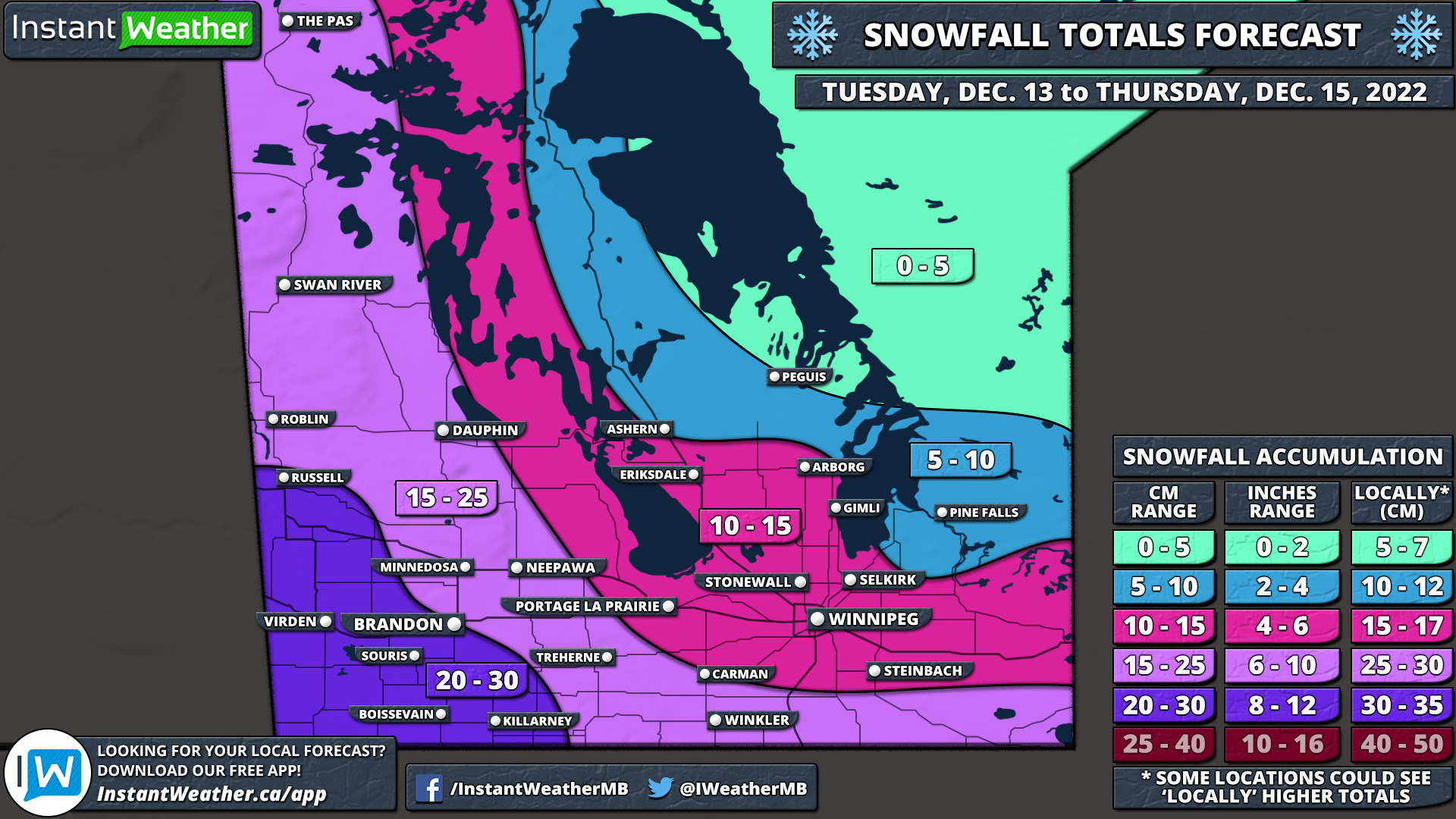
While the winter has started off on a slow note across Manitoba, that is about to change this week with a Colorado Low tracking through the province starting Tuesday evening. This will set the stage for a multi-day snowfall event as multiple rounds of precipitation affect southern parts of Manitoba between Wednesday and Friday. By the time the system moves out on Friday, we expect that total snowfall accumulation could range from 20 to 30cm in the hardest-hit locations.

The first effects of the Colorado Low will begin being felt early Tuesday evening as the initial band of precipitation crosses across the North Dakota border and into Southwestern Manitoba. As a result, the worst conditions will be found in locations such as Killarney, Boissevain, Brandon and Virden with the heaviest snowfall rates. By midnight, the moderate to heavy snowfall will have spread all across Southern Manitoba with the heaviest snow along the international border. Snow will continue overnight and into Wednesday morning although it will become more scattered later in the morning. Flurries and light snow will linger throughout the day on Wednesday and pick up in intensity towards the late afternoon and evening.

Overnight Wednesday, the focus will turn to Southwestern Manitoba with those further east getting a break from the snow. Steady snow is expected to affect regions along the Saskatchewan border into early Thursday morning before tapering off by sunrise. Another round of snow will move in during the afternoon on Thursday starting with the eastern sections of the province and slowly tracking to the west. The overnight hours on Thursday will be dominated by steady light snowfall continuing into the early part of Friday before the system responsible for this snowy weather finally moves out by the end of Friday.


Here is an advertisement so we can pay the bills:


NOTE: You can click on the map to open a zoomable image which will be easier to read.

As we will be dealing with multiple rounds of snow over the next few days, forecasting the exact accumulation is a little tricky. This isn’t a short event that lasts for 6-12 hours which is generally easier to forecast compared to a multi-day event. This also means that the impacts will be substantially less significant as the snow will fall over a long period and allow road crews to keep up with the accumulation on roads

With that being said, it appears the highest snowfall totals will be found in the southwestern corner of Manitoba with up to 20-30cm of snow expected over the next 48 hours. This includes Virden, Brandon, Milita and Killarney. 10-20cm of this snow will be on the ground by the end of Wednesday with an additional 5-10cm expected throughout the day on Thursday. The rest of Western Manitoba can expect total snowfall accumulation ranging from 10-25cm by the end of Thursday.

Moving to the eastern part of the province, the heavier snowfall totals will be contained to regions along the international border including Morden, Winkler, Emerson and Piney which could pick up around 15-25cm of snow over the next few days. South-central Manitoba including the Interlakes region along with Winnipeg and Portage La Prarie is forecasted to see 10-15cm of accumulation with the bulk of that snow coming on Wednesday.

However, there is some uncertainty on exactly how far north this system will track which would affect where the precipitation cutoff occurs. If the bands of snow make it further north than expected, these locations could certainly overachieve the forecast and approach the 15-20cm mark. Especially when it comes to elevated areas around Morden and Miami.

Current indications suggest that we could see another 5-15cm of snow on Friday in addition to what we’ve forecasted over the next two days. We have decided to leave Friday out of this forecast as it is still a few days away and it’s important to see how these first two days play out before we talk about Friday. Be sure to check for an updated forecast late Wednesday or early Thursday.


Here is another advertisement so we can pay other bills:

MANITOBA: Isolated Severe Thunderstorm Risk This Afternoon and Evening (Sunday, May 29, 2022)

NOTE: You can click on the map to open a zoomable image which will be easier to read.

We’re carefully watching for the risk of isolated severe thunderstorms this afternoon and evening across parts of southern Manitoba. There is some uncertainty as to where these storms will first develop and how late they may arrive. However, the latest model data is suggesting the strongest isolated storms will begin in the west part of the risk region this afternoon and track east throughout the evening. The main risks will be damaging wind gusts, large hail, isolated flooding and frequent lightning. There is also the potential for tornado activity, especially close to the international border. However, the tornado risk may have the potential to extend further north as highlighted by the dotted orange areas, depending on where the strongest storms develop and how earlier they arrive. The earlier they arrive, the better chance they have of being severe and potentially producing isolated tornadoes, etc.

Environment Canada has also issued a forecast map for these risks:

NOTE: You can click on the map to open a zoomable image which will be easier to read.

In their forecast, Environment Canada writes: “… potential for severe thunderstorm development. Large hail, heavy rain, and the slight chance for a tornado are all possible. However, a strong mid level capping inversion may hinder thunderstorm development until much later in the evening, once the cap erodes. As such, confidence is low for any organized storm development, but any storms that do pop up will likely be severe in nature.”


As always, if we see any rotation on radar, we will do our best to notify all those who have our free app Instant Weather and who subscribe to our premium Text Message Alerts as well as through Facebook, Twitter, etc.

If you’re on Facebook, please join our sister group Manitoba Storm Reports to share your reports with not only us but members of the community.

Long story slightly longer, thank you to all those who share our updates and support our team and community! It really makes a huge difference!

More details ASAP.

First Snowstorm of the Season Takes Aim at Saskatchewan and Manitoba With Up to 30cm of Snow Between Wednesday and Friday

A slow-moving system currently developing over Alberta is expected to bring a wintery blast of heavy snow beginning early Wednesday morning through Central Saskatchewan around Meadow Lake. This band of snow will slowly spread to the southeast towards the Yorkton region by late Wednesday morning and start to affect parts of Southern Manitoba during the day on Wednesday.

There was some uncertainty regarding precipitation type particularly through Southern Manitoba although the latest data appears to point towards a colder solution which would allow for more snow instead of rain mixing in and decreasing accumulation. As such, Winnipeg and most areas except for right along the International border will see predominately snow (likely in the form of heavy wet snow) with accumulation occurring later in the day as temperatures drop further below the freezing mark. Keep in mind that this event is still heavily temperature-dependent and a few degrees can make the difference between a few slushy centimetres and 20+cm of snow.

Snow will continue overnight into Thursday as the low-pressure system responsible for this snow stalls our and bands of precipitation wraps back in through Saskatchewan and Manitoba all day on Thursday. We will start to see some clearing later on Thursday for Saskatchewan with it lingering into early Friday for Southern Manitoba. All of the snow should be finished by Friday morning across the region except for some scattered flurries across Southwestern Manitoba.

As for accumulation, this is really tricky due to the issue with temperatures which can be hard to predict with melting. Although our target zone for the heaviest snowfall includes parts of Southeastern Saskatchewan around Yorkton and extending into Southern Manitoba around the higher elevations for Dauphin and the Interlakes region. This area can expect between 20-30cm of accumulation, but some models are pointing towards as much as 40-50cm of accumulation in localized areas mainly around Dauphin. The rest of Southern Manitoba including Winnipeg and Brandon extending through Central Saskatchewan will generally see between 10-20cm of accumulation over the next three days with most of the accumulation coming on Thursday.

Winter Returns to Manitoba With a Multi-Day Snowstorm Starting Sunday Night; Widespread Snowfall Totals Between 15-30cm Across Southern Manitoba

After a rather mild start to the weekend across Manitoba with double-digit daytime highs on Saturday, there will be a rude awakening as we head towards the end of Sunday and into the beginning of the week. Temperatures are still in the upper single-digit or low teens this afternoon for much of Southern Manitoba although that is expected to change as colder air floods into the province. During the overnight hours, we will see temperatures continue to cool down reaching near the freezing mark in many areas or the lower single digits by Monday morning. The colder air will be accompanied by a stalled out low-pressure system that will linger and merge with another system over the next few days providing ample moisture for persistent moderate to heavy snowfall beginning Monday morning (it will start Sunday night for Southwestern Manitoba along the Saskatchewan border) and continue into Tuesday. Total accumulation over the 72 hour period could exceed the 30cm mark around the Dauphin area. Please pay attention to the fact that this snowfall will be spread out over the span of 2-3 days so it won’t have as big of an impact compared to if it all came down within a 24 hour period.

Current weather radar as of Sunday afternoon indicates that an area of precipitation is currently bringing heavy wet snow to parts of Western Manitoba including the Swan River area and those along the Saskatchewan border. This will continue overnight with the snowfall mostly contained in the extreme western part of the province. Although by sunrise, we’ll see another system from Northern Ontario enter into the eastern part of the province and begin the merge with the other system that was bringing heavy snow to Western Manitoba and parts of Saskatchewan.

The precipitation with this newly merged system will wrap back around into Manitoba throughout the day on Monday and into the overnight hours. This will bring widespread heavy snowfall to much of the southern portion of the province with the heaviest accumulation expected during the afternoon. By the evening, we’ll see the bulk of the moisture focused on the Interlake region giving areas further to the south like Winnipeg and Brandon a break. Another blast of heavier snowfall is expected during the morning hours of Tuesday and into the afternoon. Snowfall will finally come to an end as we head into the later afternoon and evening hours on Tuesday with only flurries lingering around past the midnight hour.

The total accumulation from this multi-day event could reach as high as 30-50cm in a zone that includes the Dauphin area as indicated in the latest data. This could change and it’s possible that the data is overdone due to temperatures being near the freezing mark. Most of Southwestern Manitoba and the Interlake region can expect general amounts between 20-30cm except for a pocket that includes Brandon, Minnedosa and Roblin who could see less precipitation and keep totals closer to 10-15cm. The rest of Southern Manitoba including Winnipeg and Southeastern Manitoba is currently on track for totals between 10-20cm, but again this could end up being lower due to temperatures near the freezing mark and the potential for some mixing.

Significant Wind Storm and Snowfall To Start Off the Week Across Manitoba; Gusts Over 90km/h Possible

It’s almost the end of March and we’re well into spring, but the weather across Manitoba tomorrow morning and throughout the day will make it feel more like winter. A strong system developing over the Alberta Rockies is expected to move into the province Monday morning and into the afternoon bringing with it the threat of very strong wind gusts in the south and widespread snowfall to the north.

We’ll see the strongest gust in Extreme Southwestern Manitoba including Brandon, Portage La Prairie, Roblin and Virden with the maximum wind gusts ranging from 90-105km/h. The rest of Southern Manitoba will see wind gusts close to over above damaging levels around 8-95km/h including Winnipeg, Swan River and Gimli. The strong gusts will develop during the afternoon on Monday and continue into the evening before weakening overnight Monday.

For Southern Manitoba, we’re not expecting much in terms of snowfall with maybe a few flurries accumulating to up to 2cm. The heavier snowfall will be focused further north through the Interlake region with between 6 - 12cm of snowfall accumulation expected for Swan River, Dauphin, Peguis. Even higher totals are expected further north for The Pas and Norway House where snowfall and winter storm warnings are in effect from Environment Canada calling for between 15-25cm of accumulation. Conditions will improve early Tuesday as the system moves out over Northern Ontario.

Pre-Christmas Major Snowstorm to Deliver a Wintery Blast to Southern Manitoba With Up to 25-40cm Possible Between Tuesday and Wednesday

It has been a fairly quiet start to the winter season across Southern Manitoba, but that’s about to change as a significant winter storm is set to bring a heavy dumping of snow across the region. We’ve been following the developments of this system for a few days now and while the data has been fairly consistent, but there has been a trend with a more northern track in the latest data. This combined with a stronger system means we expect higher snow totals from this storm than we initially suggested. Some parts of South-central Manitoba from Roblin through the Interlake region have the potential to see final snow totals between 25-40cm with locally higher amounts around the Dauphin area.

Heavy bands of snow are expected to enter the province from Saskatchewan during the mid to late morning on Tuesday. The Roblin and Virden area will be the first to feel the effects of the storm spreading eastward throughout the rest of Tuesday. We expect the worst conditions to occur during the evening hours on Tuesday extending into Early Wednesday morning. There is still some disagreement amongst the models on how far south the bands of snow will get but at this point, we believe most of Southern Manitoba (except for Extreme Southwestern Manitoba) will see at least several hours of heavy snow. Strong wind gusts between 40-75kn/h will likely result in blowing snow out on the roads and localized blizzard conditions. Conditions will start to improve after sunrise on Wednesday with flurries lingering around into the afternoon but most of the snow on the ground by the mid to late morning.

As we mentioned above, the heaviest snowfall totals will be found from the Saskatchewan border around Roblin/Russell, eastward through the Central Interlake region and the Pine Falls area. Current indications suggest that this area has the potential to see snow totals between 25-40cm by the time the snow tapers off on Wednesday. We have also added a small zone around Dauphin where models are picking up on some localized heavier bands which may push snow totals near 50cm.

Other areas including Minnedosa, Neepawa, northern parts of Metro Winnipeg can expect final snowfall accumulation between 15-25cm with localized amounts near 30cm. The rest of Southern Manitoba including the Trans-Canada corridor from Brandon through Winnipeg is on track to see between 10-20cm. Brandon will likely be closer to the 10cm mark as per the latest data and areas south of the city will see less than 10cm due to slightly warmer temperatures.

In the wake of the storm, very cold air will flow into the province pushing temperatures to near or below -20°C across Southern Manitoba during the day on Wednesday. Even colder temperatures are expected to start the day on Christmas Eve with morning wind chills near -35°C! Temperatures will somewhat moderate as we head into Christmas morning but morning lows will still be in the mid negative teens. With these cold temperatures expected, it’s near-certain that Manitoba will see a White Christmas this year - our updated White Christmas outlook will be out on Tuesday.

.

Snowy Start to the Week Across Southern Manitoba With Up to 10-15cm of Snowfall Accumulation by Monday Afternoon

A stronger than expected system is currently affecting Southwestern Manitoba as of Sunday afternoon and will continue to sweep across Southern Manitoba through the evening and into early Monday. Snowfall will taper off sometime during the morning or afternoon on Monday as the snow moves into Minnesota and Northern Ontario.

As far as accumulation, general amounts will range from 6-12cm through the Interlakes region and into Winnipeg. Lowers totals in the southwestern corner of the province including Brandon with between 2-6cm of accumulation possible. We’re noticing a small zone just to the northwest of Winnipeg that has the potential to see over 15cm of snowfall accumulation from this system in areas such as Dauphin, Eriksdale and Selkirk.

We continue to monitor the potential for a snowstorm on Tuesday into Wednesday across Southern Manitoba. Models are quite consistent with this storm putting a swath of 15-25cm of snow extending from Brandon through to Winnipeg, but there is still some time for that to change. We’ll have a preliminary forecast out either Sunday evening or during the day on Monday once we are confident in the exact track of this system.

A Chilly and White Christmas Appears Very Likely Across Manitoba With Potential Snowstorm Tuesday Into Wednesday

This is a PRELIMINARY outlook - we will be updating it throughout the week as we get closer to Christmas.

This is a PRELIMINARY outlook - we will be updating it throughout the week as we get closer to Christmas.

It looks like a White Christmas is almost certain with snowfall already on the ground through most of Southern Manitoba. The snowpack should be safe with only a brief window of above freezing temperatures this weekend and staying below freezing from Monday through to Christmas Day. As we head into the middle of the week, even colder Arctic air will flood into the province. Overnight lows will easily drop below the -20°C mark Wednesday night and perhaps again on Christmas Eve. The current temperature forecast across Manitoba for Christmas Day has temperatures within the negative teens and maybe even colder.

We’re also closely monitoring a potential snowstorm that could affect Southern Manitoba between Tuesday and Wednesday. General snowfall totals between 10-20cm with locally as much as 25cm look possible through Brandon to Winnipeg. The track of this system is still uncertain so we’ll be waiting for a few more days until we put together a preliminary forecast. Check back later for more details!

On behalf of the entire Instant Weather team, we’d like to wish everyone a happy and joyful holiday season! We’ll continue to be here keeping you informed on any impactful weather over the holiday season and into the New Year. Here’s hoping that 2021 is much better to everyone than the dumpster fire that 2020 has been! :)

Blizzard Near Miss for Southern Manitoba; Risk of Prolonged Freezing Rain Sunday Through Monday

We’ve been closely monitoring a system that is expected to affect the Prairies this weekend over the past few days. Models have shifted around and at one point it looked like Southern Manitoba could’ve been dealing with a historic blizzard. Fortunately, that doesn’t appear possible with the latest data but what we will be dealing with instead is a risk of prolonged freezing rain starting early Sunday morning. The focus of the freezing rain threat will be on Southwestern Manitoba including Virden, Roblin, Dauphin and Swan River where up to 12-16 hours of constant freezing rain is possible. We could see fairly extensive ice accretion on untreated surfaced in these areas including rural roads, sidewalks, tree branches and power lines so expect hazardous driving conditions and power outages.

Light freezing drizzle is expected to develop sometime late Saturday into Sunday morning as the system approaches the region. There is some disagreement amongst the models on where the freezing line will be located but it should be somewhere around the Brandon and Neepawa area which means those in Western Manitoba will see some form of freezing precipitation (mainly freezing rain or ice pellets). Southcentral and Southeastern Manitoba including Winnipeg will be well above the freezing mark throughout this event and will see minimal freezing rain if any at all. In fact, during the day on Sunday, it will be quite mild for the Southeastern part of the province with the temperature reaching into the upper teens or perhaps even the low 20s! The temperature gradient throughout the province will be extremely tight so while Winnipeg basks in late summer-like temperatures, Brandon and Southwestern Manitoba will struggle to get above the freezing mark.

The precipitation will continue to become more intense during the morning hours and into Sunday afternoon. This is when we expect the worst conditions with very heavy freezing rain occurring during the afternoon and evening on Sunday. As we mentioned above, the temperature gradient will be very tight so there won’t be much distance between locations that see major impacts from the freezing rain compared to those that warm up enough to switch over to regular rain before the heavier precipitation arrives. This will be very true for locations around the Brandon area because models disagree on the exact temperature and how quickly it will warm up. The consensus is that Brandon will rise above the freezing mark just after the noon hour but if this doesn’t happen quickly enough then they could see way more ice accretion than forecasted.

It looks like the freezing line will stabilize somewhere around Virden through Peguis. Areas north of this will see mainly freezing rain while those to the south could see some freezing rain Sunday morning but will switch over to regular rain as we get into the afternoon. Further north, the storm will bring heavy snowfall to Northern Manitoba including locations such as Flin Flon, Thompson and Port Nelson could be dealing with as much as 30-50cm of snowfall by Monday. Strong winds will also be accompanied by heavy snowfall with blowing snow and blizzard-like conditions likely between Sunday evening and Monday afternoon. Precipitation will begin to taper off early afternoon on Monday although could linger around for the northern part of the province until late Monday evening.

Just a quick mention that while Southern Manitoba is missing a potential blizzard, the same can’t be said for those throughout Saskatchewan. We’re expecting widespread accumulation between 30-50cm for much of Central Saskatchewan by Monday. View our Saskatchewan forecast HERE.

Flurries and Localized Accumulating Snowfall Possible Across Southern Manitoba Between Friday and Saturday

As Alberta braces for the first winter storm of the season with more than 25cm of snow possible throughout the Rockies, Southwestern Manitoba will also be into the crosshairs of the same system on Saturday. The current model guidances suggest that the bulk of the moisture associated with this system will stay south of the border through North Dakota. As a result, the heaviest accumulation will be found in the southwestern corner of the province including locations such as Boissevain and Killarney.

The clipper will start to move into the province early Saturday morning just after midnight lasting for much of the early part of Saturday. These areas could see a few centimetres of accumulation or as much as 5cm although that’s questionable. The rest of Southern Manitoba will see little impact from the system with the higher chance of some flurries along the American border including Winkler and Steinbach. There is also the potential for lake effect flurries to develop off of Lake Winnipeg and Lake Manitoba throughout the day on Friday. It will be very scattered and not everyone will see them, but it could bring a few flakes to areas like Winnipeg, Gimli and Ashern.

Chilly Air to Invade Manitoba for the First Week of September With Temperatures Near the Freezing Mark

Valid: Tuesday, September 8, 2020

Forecast Discussion

It’s hard to believe, but we’re already heading into September and that means we have to say goodbye to the hot scorching temperatures we’ve seen this summer and hello to the colder fall nights. And Mother Nature isn’t wasting any time with temperatures near or slightly below the freezing mark to start off the first full week of September across Manitoba.

We’ll begin to see the invasion of this chilly air overnight Sunday and into Monday with overnight lows in the low to mid-single digits. The temperatures will warm up slightly during the day on Monday with daytime highs around 5-10°C. We expect the coldest temperatures will occur overnight Monday and into Tuesday morning where many areas throughout the province, especially in the Western part of Manitoba will be hovering near the freezing mark or even the low single negative digits. Central Manitoba including Winnipeg should stay above the freezing mark around 2-4°C.

When it comes to the S-word, the temperature is certainly favourable for a few flurries but there isn’t much moisture expected in the region that will be near the freezing mark Tuesday morning so most areas likely won’t see their first snow just yet. But certainly further north through the Thompson and Churchill area could see a few centimetres of snow.

This cold snap will be brief though because temperatures will warm up substantially as we head into the middle and end of the week. By next weekend, we could be talking about daytime highs in the high teens or even low 20s!

+ Attribution

Icons made by Good Ware from www.flaticon.com
Icons made by Freepik from www.flaticon.com