UPDATE: Overcast Skies Will Ruin Monday's Solar Eclipse Experience for Most Across Newfoundland

NOTE: YOU CAN CLICK ON THE MAP TO OPEN A ZOOMABLE IMAGE WHICH WILL BE EASIER TO READ.

It is now less than 24 hours until the total solar eclipse that will cross the skies over Newfoundland and being this close to the event, we’re very confident in what the conditions will be for viewing the eclipse. Newfoundland will be lucky enough to have the path of totality to cross the Island so clear skies are absolutely crucial in order to properly experience this once-in-a-lifetime event to its fullest with the drastic loss of sunlight, a drop in temperature and the visibility of the Sun’s corona.


GOOGLE AD (NOT ENDORSED BY INSTANT WEATHER)

Safety Warning

In order to safely enjoy the eclipse, it's crucial to use ISO 12312-2 certified solar glasses. Directly looking the sun, even during an eclipse, can cause serious, and possibly permanent, damage to your eyes. You can only view the eclipse without the glasses during the few minutes of totality. Solar glasses are designed to block harmful solar radiation and protect your eyes while allowing you to safely witness the event.

Never use makeshift viewing solutions like sunglasses or homemade filters, as they do not offer adequate protection against the sun's rays. Also, remember that the same rules apply to taking pictures with your phone. The sun can damage your camera’s sensors if you don’t have the proper solar filter (such as the same solar glasses for your eyes).


Your Guide to the Eclipse:


Our initial forecast showed that a majority of Newfoundland would be under clear or mostly clear skies for the eclipse on Monday afternoon, with cloud cover expected to be an issue across the Northern Peninsula, parts of Eastern Newfoundland and the Avalon. Unfortunately, the window of clear skies has shrunk considerably since we posted that initial forecast, which will make it difficult to view this special event.

Clouds will cover much of Newfoundland early Monday morning, but they will push eastward throughout the morning, leaving only Eastern Newfoundland and the Avalon with overcast skies by the lunch hour. This cloud cover will last through the afternoon, with slight breaks possible in which the eclipse may be seen. In the early afternoon, more clouds begin to move in from the west, blanketing Western Newfoundland by the beginning of the eclipse. These clouds will be denser than those in the east, making viewing the eclipse a much harder task.

It seems that the best chance to see the total eclipse will be from Gander to Grand Falls-Windsor and south to the South Shore. Beyond the path of totality, the Burin Peninsula will offer clear skies for viewing the partial eclipse.

Clouds Could Play Spoiler For Some Wishing to View the Eclipse in Newfoundland

NOTE: YOU CAN CLICK ON THE MAP TO OPEN A ZOOMABLE IMAGE WHICH WILL BE EASIER TO READ.

We’re now in the last few days before the total solar eclipse that will briefly darken the skies across Newfoundland on Monday and we’re now getting a clearer idea of the weather conditions that we can expect for that short window of totality. Clear skies are definitely a must in order to experience the full effect of the total eclipse; the drastic loss of sunlight, a drop in temperature and the visibility of the Sun’s corona.


GOOGLE AD (NOT ENDORSED BY INSTANT WEATHER)

Safety Warning

In order to safely enjoy the eclipse, it's crucial to use ISO 12312-2 certified solar glasses. Directly looking the sun, even during an eclipse, can cause serious, and possibly permanent, damage to your eyes. You can only view the eclipse without the glasses during the few minutes of totality. Solar glasses are designed to block harmful solar radiation and protect your eyes while allowing you to safely witness the event.

Never use makeshift viewing solutions like sunglasses or homemade filters, as they do not offer adequate protection against the sun's rays. Also, remember that the same rules apply to taking pictures with your phone. The sun can damage your camera’s sensors if you don’t have the proper solar filter (such as the same solar glasses for your eyes).


Your Guide to the Eclipse:

The forecast for Monday looks fairly good for eclipse watchers with most areas in the path of totality expected to be clear or mostly clear in the afternoon. The cloud cover that will blanket the island throughout the day Saturday will start to slowly diminish Sunday morning, resulting in clear skies for most of Newfoundland by Monday morning which will last through the eclipse.

However, at this point, it doesn’t appear that the clouds will fully disappear, which will greatly impact eclipse viewing in the Northern Peninsula as well as in the Baie Verte and Bonavista Peninsulas, and the Northern Avalon.


First Snowstorm of 2024 Is Taking Aim at Eastern Newfoundland With Up to 30cm of Snow on Friday

NOTE: YOU CAN CLICK ON THE MAP TO OPEN A ZOOMABLE IMAGE WHICH WILL BE EASIER TO READ.

As we embark on the new year, Eastern Newfoundland is bracing for its first significant weather challenge. Only a few days into the year, we find ourselves anticipating a major storm. This storm is expected to usher in a considerable amount of snow, starting Friday morning and persisting until Saturday morning.

This imminent snowfall is attributed to a low-pressure system set to pass east of the province. While a substantial snow accumulation of over 10cm is forecasted for most of Eastern Newfoundland, the Avalon Peninsula is anticipated to bear the brunt of this storm. Here, snow accumulations could reach up to 30cm, with the possibility of even higher local amounts.


GOOGLE AD (NOT ENDORSED BY INSTANT WEATHER)

The onset of the snow is slated for Friday morning and is likely to extend into the late hours of Friday or the early hours of Saturday. The intensity of the snowfall is expected to peak later in the afternoon and continue into the evening. Particularly on the Avalon Peninsula, snowfall rates could approach 5cm per hour over several hours.

Concurrently, wind gusts reaching speeds of up to 80km/h are predicted to commence and persist through the night. These conditions are likely to create blizzard-like scenarios, severely hampering visibility and making driving conditions very dangerous.


GOOGLE AD (NOT ENDORSED BY INSTANT WEATHER)

Residents should prepare for significant disruptions caused by this storm. The combination of heavy snow and strong winds is likely to impact roadways, potentially leading to hazardous travel conditions. It is advisable to stay updated on weather conditions and plan accordingly to ensure safety during this period of active weather.


GOOGLE AD (NOT ENDORSED BY INSTANT WEATHER)

Heavy Rains to Heavy Snow in Western Newfoundland Bringing Up to 60cm Through Friday

NOTE: YOU CAN CLICK ON THE MAP TO OPEN A ZOOMABLE IMAGE WHICH WILL BE EASIER TO READ.

Moisture continues to stream into the province from the south, and this trend is expected to persist throughout Friday and possibly into Saturday morning before a pause in the precipitation occurs. However, a surge of cold air from the west will transition the recent heavy rains into heavy snow starting overnight and into early Friday morning.


GOOGLE AD (NOT ENDORSED BY INSTANT WEATHER)

The shift will first occur over the Northern Peninsula, then gradually spread south and east into Central Newfoundland during the afternoon.

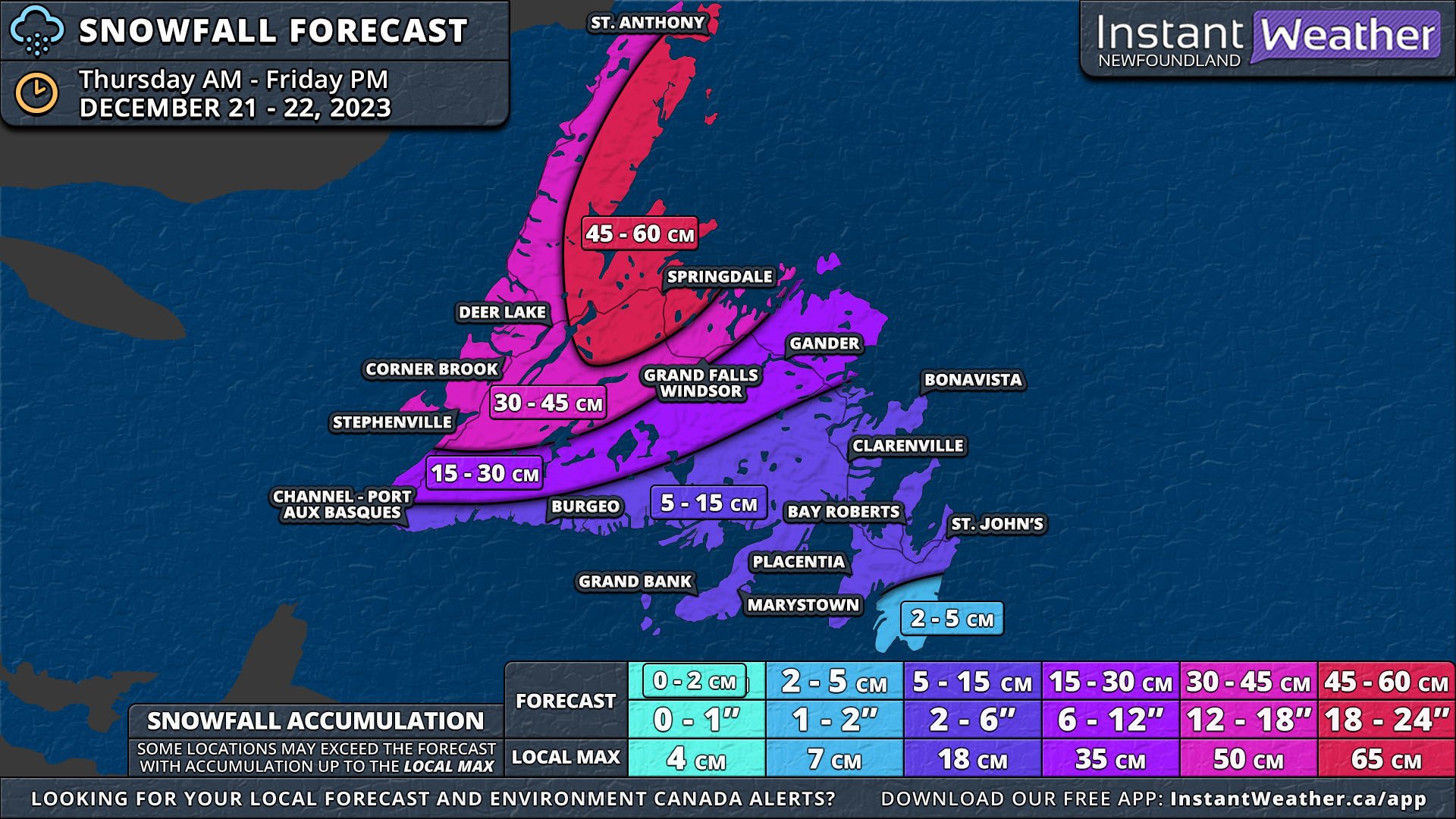
Expect the snow to be intense at times, with a broad area of Western Newfoundland—including the eastern half of the Northern Peninsula, the Connaigre Peninsula, and areas extending southward towards Deer Lake—anticipating over 60cm of snow, and potentially more in localized areas, by Friday's end.

Accompanying this significant snowfall will be wind gusts nearing 100km/h, creating occasional blizzard conditions that will make travel treacherous.


GOOGLE AD (NOT ENDORSED BY INSTANT WEATHER)

In areas of Western Newfoundland less affected, the remainder of the Island will begin to see snow by Friday afternoon as the cold air pushes eastward, gradually converting the rain to snow. This transition may include brief periods of freezing rain and/or ice pellets.

Snowfall totals in Central and Eastern Newfoundland will be considerably lower, with most of Central Newfoundland expecting under 30cm and Eastern Newfoundland, including the Avalon, less than 15cm.

The Southeast Avalon will experience the least snowfall, with no more than 5cm predicted by Friday's end. Along the South Coast, the rain will continue before it transitions to snow, placing Port-Aux-Basques and Burgeo in the 5-15cm range.


GOOGLE AD (NOT ENDORSED BY INSTANT WEATHER)

Not a Typo: An Additional 200+mm of Rain for Parts of Newfoundland & More Rain for Already Drenched Nova Scotia

NOTE: YOU CAN CLICK ON THE MAP TO OPEN A ZOOMABLE IMAGE WHICH WILL BE EASIER TO READ.

After a wet and windy Tuesday, Western Newfoundland, particularly along the South Coast, braces for continued heavy rainfall overnight and into Wednesday. The hardest-hit areas may experience rainfall rates surpassing 10mm/hr, likely leading to flooding and road washouts.


GOOGLE AD (NOT ENDORSED BY INSTANT WEATHER)

By Thursday morning, a shift to colder air will see the rain on the Northern Peninsula gradually transform into snow, extending south and east into Central Newfoundland by afternoon.

This snowfall, heavy at times, could leave Western Newfoundland under a blanket of up to 60cm by Friday's end. Accompanying wind gusts up to 100km/h are expected, potentially causing blizzard conditions and making travel treacherous.

Thursday night into Friday, the snow will extend to Eastern Newfoundland and the Avalon, with accumulations ranging between 5-15cm for most areas. A detailed snowfall forecast map will be available Wednesday evening.


GOOGLE AD (NOT ENDORSED BY INSTANT WEATHER)

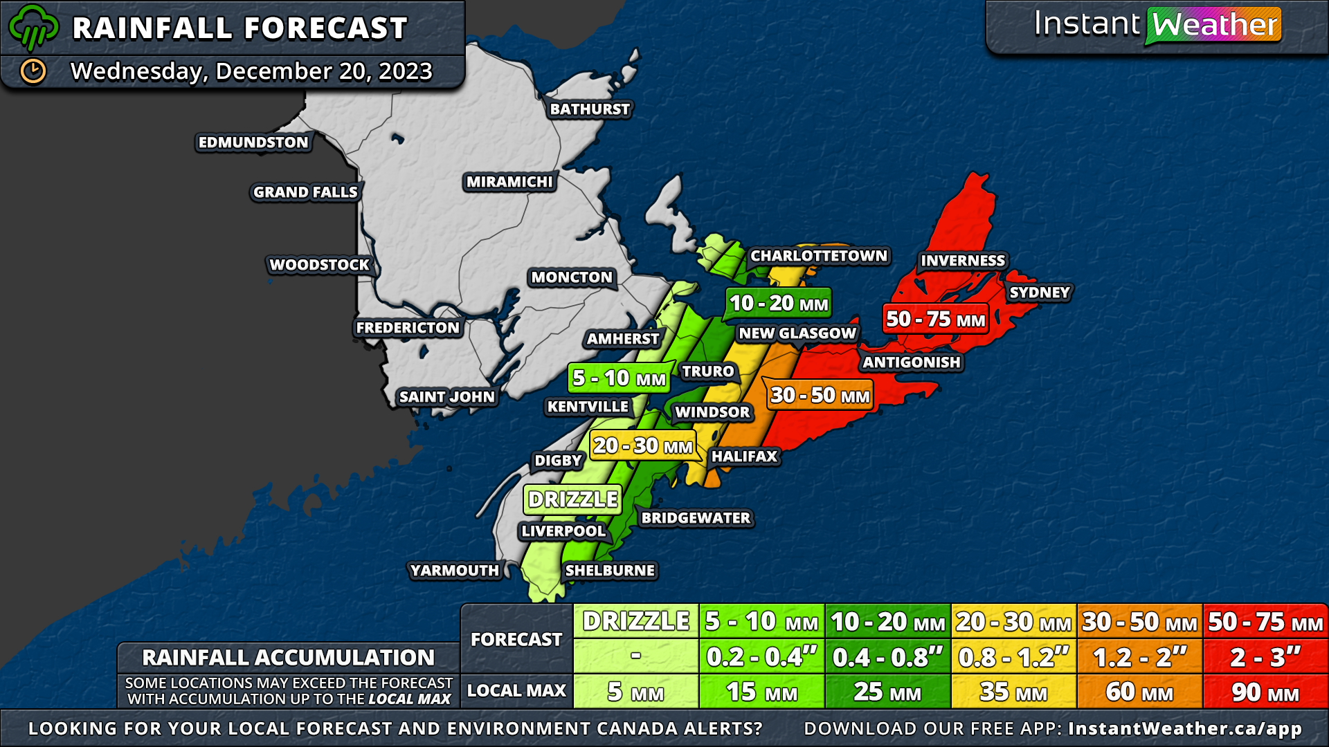
In the meantime, across the Cabot Strait, a rainy start to the week that saw Halifax and east of the city getting hit with 50-100+mm of rain will continue Wednesday when an additional 20-75mm will fall, with the higher amounts further eastward.

Meanwhile, across the Cabot Strait, Halifax and its eastern areas, already drenched with 50-100+mm of rain, anticipate an additional 20-75mm on Wednesday, with the heftier totals expected further east. This mirrors the flood and washout concerns seen in Southern Newfoundland, with up to 75mm of rain forecasted for the Eastern mainland and Cape Breton Island, where rainfall rates could reach 15mm/hr.

New Brunswick is set for a respite from the rain, unlike most of Prince Edward Island. While Prince County might experience minimal rain or drizzle, a stark contrast in Queens and Kings Counties will see drizzle in the west and over 30mm of rain along the eastern coast of Kings County. The rain in PEI, however, will be shorter-lived than in Nova Scotia, concluding Wednesday evening.


GOOGLE AD (NOT ENDORSED BY INSTANT WEATHER)

Nova Scotia on Thursday will see light rain persist overnight. Early Thursday might bring a brief period of freezing rain before it clears from the eastern mainland. Cape Breton Island may also undergo this freezing rain phase, transitioning to light snow that could last throughout the day and into early Friday. A snowfall forecast for this region will be posted on Wednesday evening as well.