Not a Typo: An Additional 200+mm of Rain for Parts of Newfoundland & More Rain for Already Drenched Nova Scotia

NOTE: YOU CAN CLICK ON THE MAP TO OPEN A ZOOMABLE IMAGE WHICH WILL BE EASIER TO READ.

After a wet and windy Tuesday, Western Newfoundland, particularly along the South Coast, braces for continued heavy rainfall overnight and into Wednesday. The hardest-hit areas may experience rainfall rates surpassing 10mm/hr, likely leading to flooding and road washouts.


GOOGLE AD (NOT ENDORSED BY INSTANT WEATHER)

By Thursday morning, a shift to colder air will see the rain on the Northern Peninsula gradually transform into snow, extending south and east into Central Newfoundland by afternoon.

This snowfall, heavy at times, could leave Western Newfoundland under a blanket of up to 60cm by Friday's end. Accompanying wind gusts up to 100km/h are expected, potentially causing blizzard conditions and making travel treacherous.

Thursday night into Friday, the snow will extend to Eastern Newfoundland and the Avalon, with accumulations ranging between 5-15cm for most areas. A detailed snowfall forecast map will be available Wednesday evening.


GOOGLE AD (NOT ENDORSED BY INSTANT WEATHER)

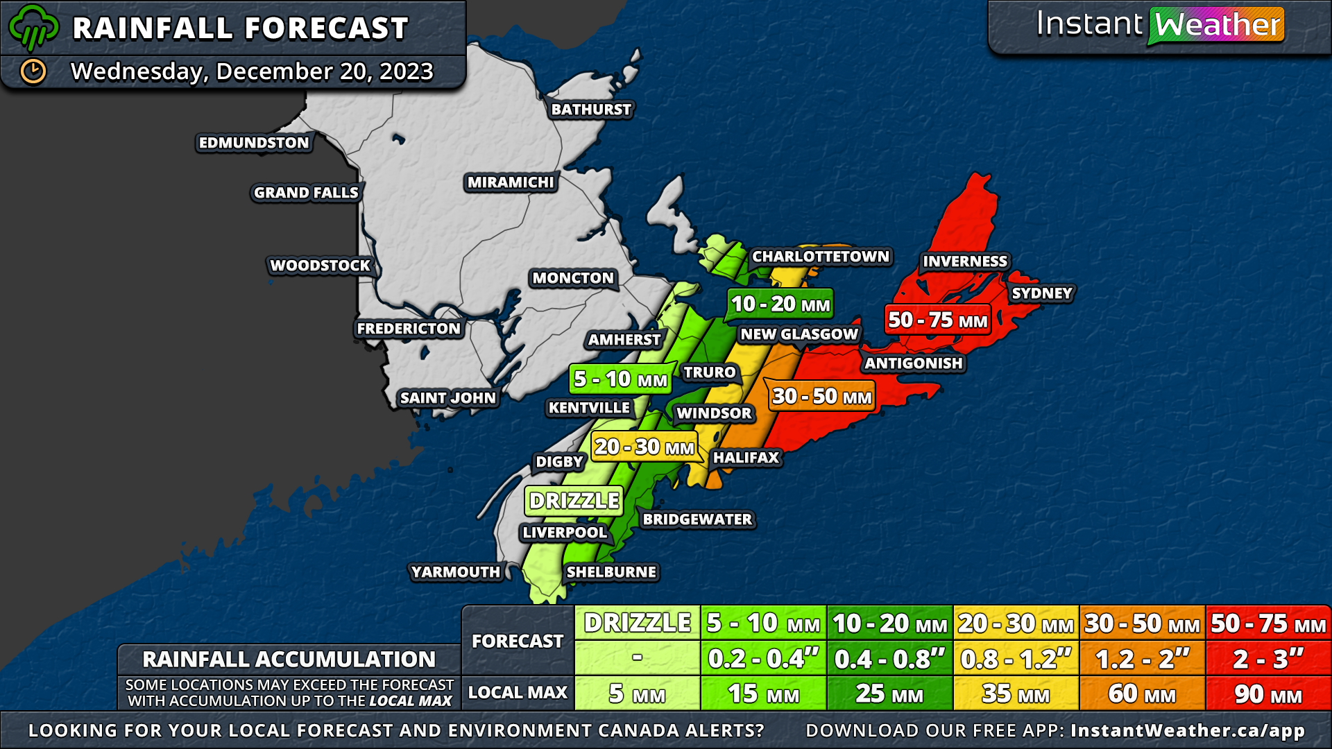
In the meantime, across the Cabot Strait, a rainy start to the week that saw Halifax and east of the city getting hit with 50-100+mm of rain will continue Wednesday when an additional 20-75mm will fall, with the higher amounts further eastward.

Meanwhile, across the Cabot Strait, Halifax and its eastern areas, already drenched with 50-100+mm of rain, anticipate an additional 20-75mm on Wednesday, with the heftier totals expected further east. This mirrors the flood and washout concerns seen in Southern Newfoundland, with up to 75mm of rain forecasted for the Eastern mainland and Cape Breton Island, where rainfall rates could reach 15mm/hr.

New Brunswick is set for a respite from the rain, unlike most of Prince Edward Island. While Prince County might experience minimal rain or drizzle, a stark contrast in Queens and Kings Counties will see drizzle in the west and over 30mm of rain along the eastern coast of Kings County. The rain in PEI, however, will be shorter-lived than in Nova Scotia, concluding Wednesday evening.


GOOGLE AD (NOT ENDORSED BY INSTANT WEATHER)

Nova Scotia on Thursday will see light rain persist overnight. Early Thursday might bring a brief period of freezing rain before it clears from the eastern mainland. Cape Breton Island may also undergo this freezing rain phase, transitioning to light snow that could last throughout the day and into early Friday. A snowfall forecast for this region will be posted on Wednesday evening as well.

Yet Another Strong Rain & Wind Storm Takes Aim at the Maritimes to Start the Week

NOTE: YOU CAN CLICK ON THE MAP TO OPEN A ZOOMABLE IMAGE WHICH WILL BE EASIER TO READ.

This week opens with a familiar scenario: wet and windy conditions as another storm lashes the Maritimes. A low-pressure system travelling up the American coast is set to affect the region from late Sunday through Tuesday.

The storm is expected to deliver rainfall ranging from 10mm to over 100mm, accompanied by wind gusts surpassing 100km/h.


GOOGLE AD (NOT ENDORSED BY INSTANT WEATHER)

The onset of rain in Western New Brunswick late Sunday will mark the storm's arrival, spreading eastward into Nova Scotia and PEI overnight and continuing into Monday morning.

Intensifying by Monday afternoon, rainfall rates are expected to exceed 5mm/hr, reaching up to 10mm/hr in the hardest hit areas. The downpour will gradually diminish overnight, with lingering rain in Eastern Nova Scotia into Tuesday.

Unlike last week's storm, Nova Scotia is on tap for the heaviest rainfall from this system, anticipating over 100mm east of Halifax and isolated areas possibly receiving upwards of 125mm. The Halifax Region is likely to see 75-100mm, while a broad section of the province faces 50-75mm.

Areas like Cumberland County, the Annapolis Valley, Yarmouth and Shelburne Counties, and most of Cape Breton will see around 25-50mm. However, the tip of Inverness and Victoria Counties will see the least, with less than 25mm forecasted. Given the rapid accumulation, localized flooding is a significant concern, particularly in and around Halifax.


GOOGLE AD (NOT ENDORSED BY INSTANT WEATHER)

New Brunswick's rainfall totals will be more modest, with a general expectation of 25-50mm province-wide, including Woodstock, Fredericton, Moncton, and Saint John. Northern and Eastern parts of the province anticipate 10-25mm, spanning from Edmundston to Bathurst and nearly reaching the Chignecto Isthmus.

The highest rainfall totals in the province, between 50-75mm, is predicted for Southwest New Brunswick. PEI's rainfall totals will differ from last week, with lesser amounts in the west and more in the east.

Prince County and western Queens County can expect 10-25mm, while the bulk of Queens County and Kings County are likely to receive 25-50mm.


GOOGLE AD (NOT ENDORSED BY INSTANT WEATHER)

As with last week’s storm, strong wind gusts are anticipated with this storm. New Brunswick can expect gusts up to 95km/h, intensifying to over 100km/h in the south along the Fundy Region.

Prince Edward Island may experience slightly stronger winds than last week, with gusts potentially exceeding 100km/h.

Nova Scotia will encounter similar windy conditions to the previous storm, with widespread gusts of 85-95km/h and up to 110km/h along coastal areas.

The potential for power outages remains high, especially as some trees and branches were weakened by last week's storm.

Currently, models indicate a second system could bring more rain to the region, but are divided on its trajectory. One model suggests additional rainfall over Eastern Nova Scotia, while another predicts the storm will remain well offshore.

Any extra rainfall could exacerbate the already heightened flood risks in the area.

Batten Down the Hatches Maritimes! Very Windy and Wet Day in Store for Monday

NOTE: YOU CAN CLICK ON THE MAP TO OPEN A ZOOMABLE IMAGE WHICH WILL BE EASIER TO READ.

A powerful storm is pushing its way northward along the American East Coast and the leading edge has already started to push into the Maritimes with rain beginning to fall in New Brunswick.

While rain is expected to some degree across the entire region, New Brunswick will see the bulk of it, with some areas looking at up to 75mm by the end of the day tomorrow.


GOOGLE AD (NOT ENDORSED BY INSTANT WEATHER)

The rain will be light to start, before increasing in intensity overnight and remaining steady throughout the day and rainfall rates may exceed 5mm/hr at times during the morning.

In the Northwest Region, cooler temperatures will result in most of the precipitation to fall as snow, meaning that instead of 50-75mm of rain, this area is looking at upwards of 30cm of snow.

Beyond New Brunswick, precipitation becomes less of an issue for most of the rest of the Maritimes. Nova Scotia and PEI can expect 5-20mm of rain, with the exception of Prince County where 20-50mm of rain is possible.


GOOGLE AD (NOT ENDORSED BY INSTANT WEATHER)

As the centre of the storm approaches and crosses through the Maritimes on Monday, the winds will begin to ramp up, peaking in the early afternoon. The strongest wind gusts will be over 100km/h for coastal areas in Southern New Brunswick and across Western and Central Nova Scotia.

These strong gusts will penetrate quite far inland meaning the rest of Nova Scotia, most of Central and Southern New Brunswick and the entirety of PEI can expect wind gusts over 80km/h. These strong winds will very likely result in widespread power outages across the entire region.