Winter Returns to Southern Ontario This Week With Heavy Rainfall Followed by Up to 15-20cm of Lake-Effect Snow by Tuesday
/
NOTE: YOU CAN CLICK ON THE MAP TO OPEN A ZOOMABLE IMAGE
It's hard to believe, but we're nearly a week away from Christmas Day, and most of Southern Ontario, except the snowbelt region, has yet to witness a significant snowfall this season. The little snow we've had quickly vanished, courtesy of the unusually mild start to December, with temperatures reminiscent of late fall or early spring.
However, a shift in the weather pattern is on the horizon as we approach the final week before Christmas, bringing the return of more conventional winter conditions. This change includes widespread snowfall expected between Monday and Tuesday, intensified by heavier lake effect snow bands around Lake Huron, Georgian Bay, and even Lake Ontario.
Temperatures are also poised to plummet, with much colder air sweeping across the province. We anticipate a brisk Tuesday morning, where, factoring in wind chill, it could feel like the negative teens or even lower, a stark contrast to the double-digit temperatures we've enjoyed on several days in recent weeks.
NOTE: YOU CAN CLICK ON THE MAP TO OPEN A ZOOMABLE IMAGE
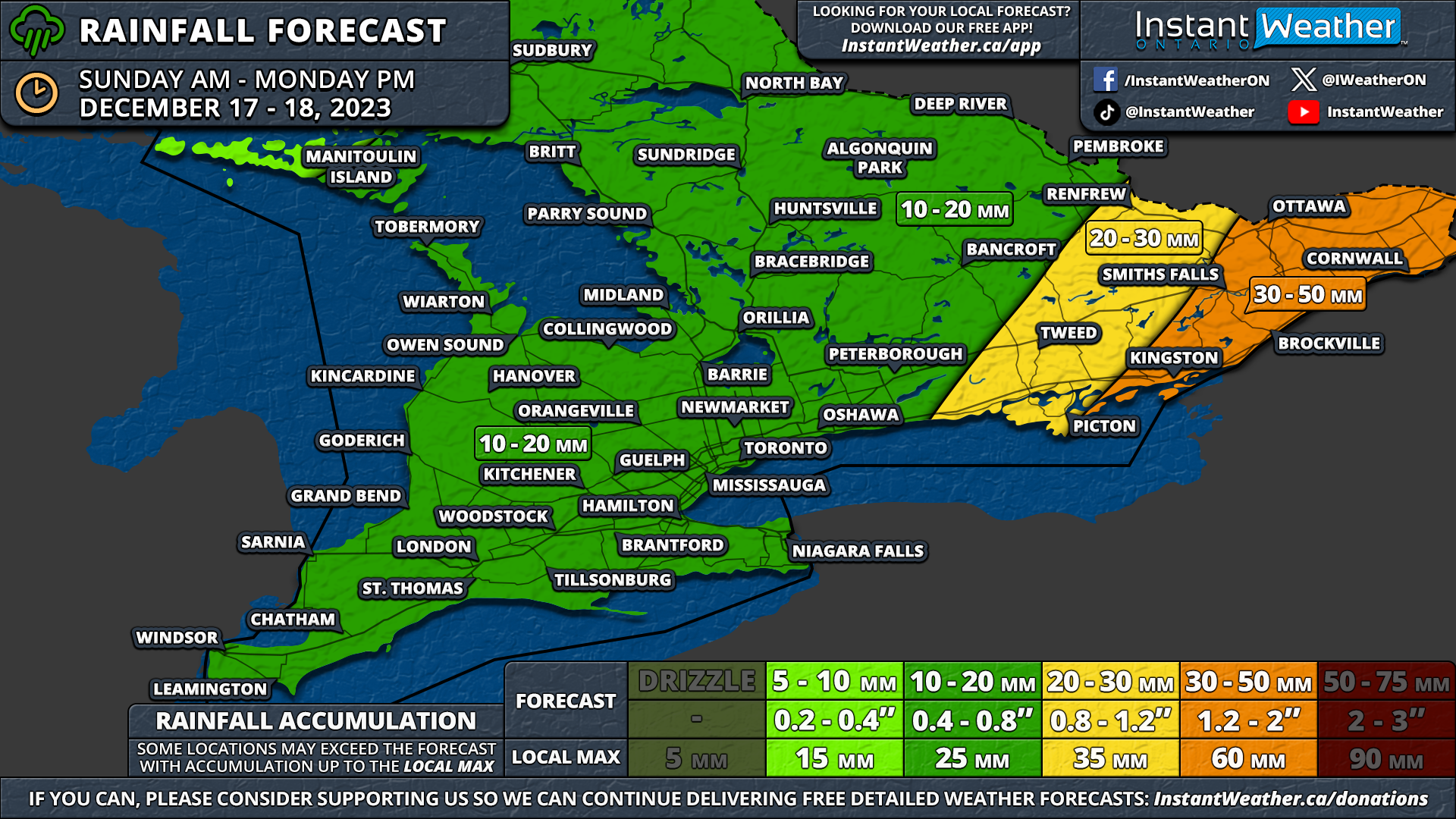
Before Southern Ontario resumes its typical winter programming, a spell of milder weather is still holding on this weekend. As of Sunday afternoon, widespread rainfall is sweeping across the region.
Another bout of intense precipitation is set to hit Eastern Ontario overnight into Monday morning, courtesy of the outer precipitation bands of a potent system moving up the US East Coast. While the brunt of this storm will stay to our east, the trajectory does bring substantial rain to Extreme Eastern Ontario along the international border.
Rainfall totals across Southern Ontario for Sunday are projected to be between 10 to 15mm, with some areas receiving up to 20 to 25mm. Eastern Ontario is expected to experience heavier rainfall, with accumulations of 30 to 50mm around Kingston, Ottawa, Brockville, and Cornwall. Locally, totals exceeding 50mm can’t be ruled out, particularly east of Ottawa.
The rain should recede across Southern Ontario by late Sunday evening, although Eastern Ontario may continue to experience heavy rain into Monday morning.

NOTE: YOU CAN CLICK ON THE MAP TO OPEN A ZOOMABLE IMAGE
Following the system to our east, a gradual cooling will ensue on Monday, with temperatures nearing the freezing mark later in the day, starting in Southwestern and Central Ontario.
Late Monday, a wave of weak precipitation is expected to track across Southern Ontario, beginning with light drizzle and transitioning to flurries as temperatures fall. There's some uncertainty regarding the intensity of this snowfall, as lake enhancement off the Great Lakes will primarily drive it.
Additionally, localized snow squalls are anticipated to develop off Lake Huron, Georgian Bay, and Lake Ontario, starting Monday evening and persisting into early Tuesday.
Steady snowfall is forecasted across Southern Ontario during the overnight hours and early Tuesday morning. While the heaviest snow will be concentrated near the lakes, it seems that even inland areas in Eastern and Central Ontario will see a light dusting.
Our focus is on areas south of Georgian Bay, Lake Huron, and parts of the Niagara region, where heavier snow bands are expected off the lakes.
The snow should taper off by Tuesday morning's end, though some lake-effect flurries might linger in the snowbelt regions.

NOTE: YOU CAN CLICK ON THE MAP TO OPEN A ZOOMABLE IMAGE
Current projections indicate the potential for 10 to 20cm of snow in two specific areas: south of Collingwood over the Blue Mountains off Georgian Bay and east of Sarnia around Petrolia and Lambton Shores, due to expected heavier lake effect snow overnight into Tuesday morning. Not everyone will experience such significant snowfall, as the bands will be narrow and unpredictable.
Heavier snow is also forecasted along the southern shoreline of Lake Ontario in the Niagara region, with 10 to 15cm possible between Grimsby and Niagara-on-the-Lake, while the rest of the Niagara region might see around 5cm.
Away from the lakes, the models are divided, with some higher-resolution models predicting less snow for Central and Eastern Ontario, while others suggest much more. We're currently estimating a general 5 to 10cm of snow, though actual totals will likely vary across the region.
Hence, some areas might exceed these predictions, especially in Eastern Ontario, while others may not reach the 5cm mark. The rest of Southern Ontario, including the GTA and Deep Southwestern Ontario, should expect a few centimetres of snow over the coming days.
