UPDATE: Now Three EF1 Tornadoes Confirmed From June 20th, Including a 1.2 KM Wide Tornado
/UPDATE: The Northern Tornadoes Project has now confirmed three EF1 tornadoes in Southern Manitoba that occurred on Tuesday, June 20th, 2023. Our thoughts remain with those affected.

The NTP initially wrote:
”Two NTP ground/drone survey teams have been busy in SW Manitoba after the intense evening storms of June 20th there. Initial results are that two tornadoes occurred, each rated EF1.”
And have since followed that up with:
”An NTP survey has turned up a third EF1 tornado from the June 20th storms in southwest Manitoba…”


Below are some highlights from the NTP’s summary:
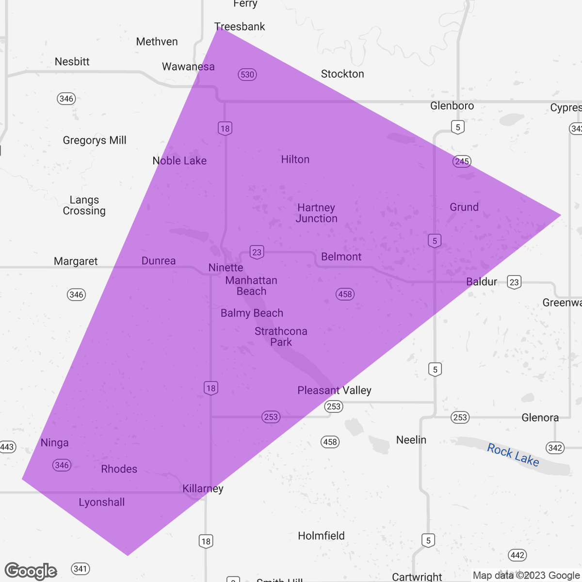
”Structural and tree damage reported in (Sidney/MacGregor) area. No injuries were reported. An NTP ground and drone survey was completed in the area… …documenting the structural damage along with grain bin damage and tree damage along a track appox. 7 km long and 800 m wide at maximum. Damage assessed as EF1 tornado (over land), with an estimated max. wind speed of 135 km/h.”
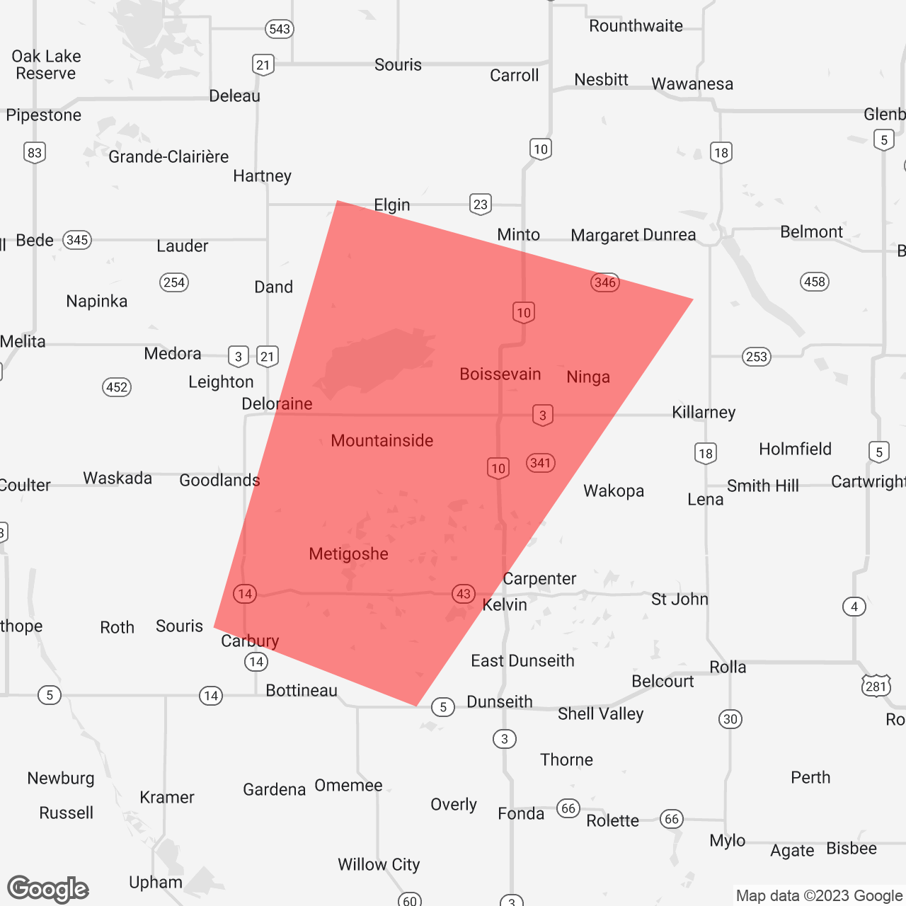
”Satellite imagery review revealed a tornado damage path in a forested area that likely started approximately 100 m south of the Canadian border near Carpenter, ND, with most of the damage (including the worst) occurring in Canada. An NTP drone survey of the Canadian portion of the tornado track was completed on June 23, 2023. A preliminary analysis of the Canadian portion of the track was completed by NTP. Event was assessed as EF1 tornado, with an estimated max. wind speed of 145 km/h, track length of 6.50 km and max. path width of 210m.”
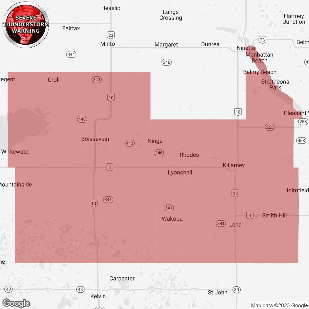
“Structural and tree damage was reported in the Killarney - Ninette area following a storm passing though. An NTP ground and drone survey was completed on June 21 and 22, 2023…” “…Event was assessed as EF1 tornado, with an estimated max. wind speed of 155 km/h, track length of 17.5 km and max. path width of 1.2 km.” “…Further investigation is pending, including satellite imagery review and additional drone imagery review.”
Below is a timeline of the event regarding forecasts, alerts and custom notifications:

On Monday, June 19th at 2:04 PM, Environment Canada issued a timely “Moderate” forecast that mentioned the risk for a tornado in Southern Manitoba. They mentioned; “Severe thunderstorms tomorrow in the yellow area. Very large hail, very strong wind gusts, and very heavy rain are the main threats with risk of tornado. Stay up to date with watches and warnings.”
On Tuesday, June 20th at 12:18 AM during our livestream of the severe weather event the night before, we debuted our custom forecast and initially went with a “Significant” forecast for “Several Tornadoes”.


Environment Canada updated their forecast to a “High” risk on Tuesday, June 20th at 11:44 AM, which still included a tornado risk on the map. ”An update for the orange area. Winnipeg and Brandon are in a new yellow area. Very large hail, strong wind gusts, and very heavy rain are possible in this new yellow region.”
Later that afternoon at 12:55 PM, we updated our forecast to a “Strong” forecast but added a Significant Hail Risk region to the map and shared it with the headline; ”Potential Significant Severe Threat in Southern Manitoba for Tuesday Evening With the Risk of Tornadoes”.
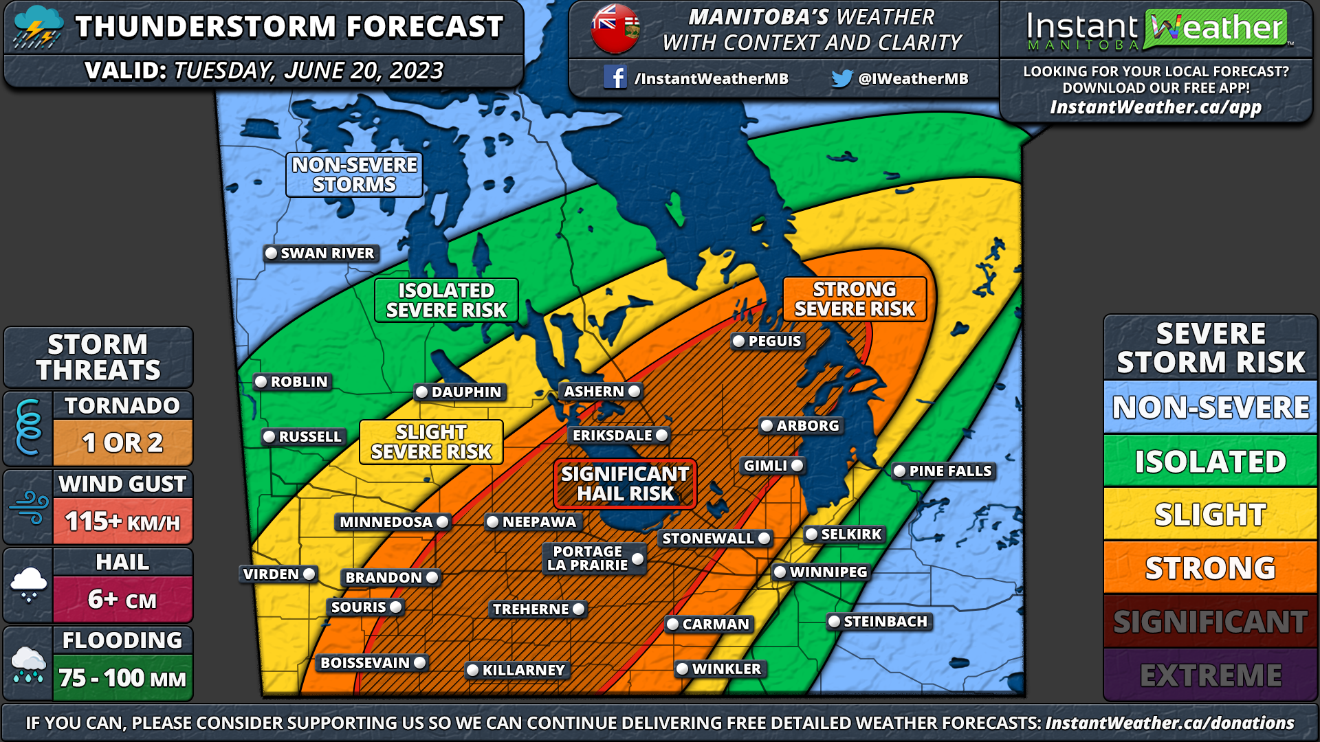

At 3:27 PM, Environment Canada issued a Severe Thunderstorm Watch for parts of Southwestern Manitoba and wrote: "Conditions are favourable for the development of severe thunderstorms this afternoon and this evening in parts of Southern and Eastern Manitoba. The main threats from these thunderstorms will be: - hail to the size of baseballs - wind gusts in excess of 100 km/h - rainfall in excess of 50 mm. Thunderstorms will continue well into the evening hours.”
At 4:27 PM, we at Instant Weather launched what would end up being an eight hour livestream (one of our longest) with the title “MANITOBA LIVESTREAM: Tornado Risk” to cover these storms in real-time and we linked this video to roughly when these storms coming across the international border began to strengthen on radar before ultimately producing two EF1 tornadoes with one area of damage still under investigation.
At 8:52 PM, 43 minutes in advance of the first touchdown, Environment Canada issued a Severe Thunderstorm Warning for the affected areas that mentioned “Environment Canada meteorologists are tracking a severe thunderstorm capable of producing loonie-sized hail and wind gusts in excess of 90 km/h.”
At 8:53 PM (42 minutes before touchdown), we sent out a custom notification regarding the storms that were tracking across the border which said; “Minor Rotation Detected: We've detected minor rotation on this storm just crossing the international border, heading northeast towards #Boissevain, #Ninga, etc." Upper level rotation is much stronger than surface based rotation but strong damaging winds are also possible. In rare cases, minor rotation can produce a tornado in its lifespan.”

At 8:55 PM (40 minutes before touchdown), we sent out another custom notification to the same region that said “TORNADO POTENTIAL: We've detected tornado potential with this storm just crossing the international border, heading northeast towards #Boissevain, #Ninga, etc. Significant hook-echo and strong rotation now evident on US radar. Tornado potential means this storm is likely to produce an isolated tornado. Damaging wind gusts, hail, isolated flooding, and frequent lightning are also likely. Please be safe in the path of this storm!”
At 9:01 PM (34 minutes before touchdown), we shared a radar image of the storms tracking to the northeast towards the affected regions and wrote “Shelter NOW on this storm about to cross into Manitoba south of Boissevain. Very strong signs of rotation.”


At 9:11 PM, Environment Canada continued the Severe Thunderstorm Warning which mentioned “Environment Canada meteorologists are tracking a severe thunderstorm capable of producing loonie-sized hail and wind gusts in excess of 90 km/h. At 9:10 P.M. CDT doppler radar indicated that this severe thunderstorm was located South of Deloraine and Turtle Mountain Provincial Park and was moving toward the Northeast at 40 km/h.”
At 9:44 PM, we noticed a very small rotation couplet on radar during our livestream which ended up being the signature for the first EF1 tornado as it crossed into Canada.


At 9:57 PM, we sent out a custom notification that said; “DEBRIS SIGNATURE: There is a debris signature on US radar near #Wakopa, tracking northeast into #Killary area. Take shelter in the path of this storm. Tornado potential means this storm is likely to produce an isolated tornado. Damaging wind gusts, hail, isolated flooding, and frequent lightning are also likely. Please be safe in the path of this storm!”
At 10:00 PM, we sent out a custom notification on a new area of rotation as the second tornado was beginning its 17.5km journey and wrote: “TORNADO RISK: A tornado is possible with this storm west of #Killarney, tracking to the northeast. If you are in the path, get to the lowest level (preferably a basement) of a sturdy structure and get to the most interior room that has as many walls between you and the outside as possible. Damaging wind gusts, hail, isolated flooding, and frequent lightning are also possible with severe thunderstorms. Please be safe in the path of this storm!”
In summary, we’re so thankful that there were no reported injuries from these two dangerous tornadoes and super grateful that we were able to help those in the path get to safety by send out custom notifications via our free app Instant Weather. Our thoughts remain with those who were affected and a huge thank you to the NTP for their timely and detailed survey.
