Fireball Lights Up the Sky (October 20 2021)

Credit ChRIS Johnson (Screen capture of video)

Did you see a fireball on October 20 2021 at approximately 12:43am? Perhaps you unknowingly captured it on a security camera.

It was seen by community members and Bonnie W. L. reported in our Ontario Storm Reports group. Kirk P. also was lucky enough to capture it on video and shared it in the group as well.

About 81 reports (to date) of this bright fireball have been submitted to American Meteor Society from observers mostly in US and Ontario. Below is the current map of the observers from the American Meteor Society event page. The path of the fireball is indicated by the blue arrow.

Map from AMS of observer locations

This video was taken by Chris Johnson in Fort Gratiot Township, US close to Sarnia, Ontario.

Here is another video from MK on YouTube.

In this case this was not a fireball of natural origins but rather a failed Russian Spy satellite. It was impressive sight nonetheless. It was very bright and fragmented upon entry.

This event was predicted and no debris was expected to reach the ground.

NASA Meteor Watch also posted about the event. See space.com’s article for more information as well.

You can report fireball observations (and also send in videos if you have them) to the American Meteor Society (AMS) or it’s partner the International Meteor Organization (IMO). The reports not only alert them to potentially scientifically significant events, they also add to the database of knowledge about meteors. In this case the observations were able to determine that the fireball was not of natural origins.

Fireball Lights Up the Sky near Ottawa (August 20 2021)

Did you see a fireball on Friday August 20 2021 at approximately 10:37pm? Perhaps you unknowingly captured it on a security camera.

Thank you to everyone that posted about it in the Ontario Storm Watch group and Anna B. who sent us her door cam video from Nepean.

About 43 reports (to date) of this bright fireball have been submitted to American Meteor Society from observers mostly in Ontario and Quebec. This video was taken by Sam Berrada.

Here is another video from wacb on YouTube.

You can report fireball observations (and also send in videos if you have them) to the American Meteor Society (AMS) or it’s partner the International Meteor Organization (IMO). The reports not only alert them to potentially scientifically significant events, they also add to the database of knowledge about meteors.

We are keeping an eye on the NASA Meteor Watch page as well as they will often provide information on significant fireballs and will update this page with more information if/when it becomes available.

Perseid Meteor Shower 2021

Photo Credit: NASA/Bill Ingalls - In this 30 second exposure, a meteor streaks across the sky during the annual Perseid meteor shower Friday, Aug. 12, 2016 in Spruce Knob, West Virginia.

Photo Credit: NASA/Bill Ingalls - In this 30 second exposure, a meteor streaks across the sky during the annual Perseid meteor shower Friday, Aug. 12, 2016 in Spruce Knob, West Virginia.

The best meteor shower of the year is upon us - the Perseids. This year we are expecting as many as 100 Perseids an hour on August 11-12. The best time to observe the shower is during the hours before sunrise on Thursday morning. Since this shower lasts from July 17 to August 24 you can see Perseid meteors before and after the peak. The Perseids are the debris from the comet Swift-Tuttle which has a 133 year orbit around our Sun.

One good way to view meteors is to just lie down and watch the sky in a dark place. August nights can sometimes be cool depending on your location so as well as a blanket or lounge chair to lie on you might want to bring a jacket, your favourite hot drink and bug spray. This year though some places are seeing unseasonable warm nights so best to check your local forecast. If you can let your eyes get adjusted to the dark before you go out to look for meteors. You can do this by avoiding bright lights including looking at your phone for 30 minutes. Even if the weather doesn’t cooperate on the night of your first choice there will be other chances to watch the Perseids.

Photo credit: NASA/JPL - An outburst of Perseid meteors lights up the sky in August 2009 in this time-lapse image.

Photo credit: NASA/JPL - An outburst of Perseid meteors lights up the sky in August 2009 in this time-lapse image.

The radiant (where the meteors appear to originate) is in the constellation called Perseus, hence the name Perseids. The constellation Perseus rises higher in the sky as the night progresses so observing later, after 2am, means you will see more meteors. This year the phase of the moon is in our favour so we should be able to see fainter meteors than in previous years.

As well as the Perseids there are also sporadic meteors at the rate of a few per hour. You may also catch a meteor from a weaker shower that is active right now as well (Alpha Capricornids, Southern Delta Aquariids, and Kappa Cygnids). If you can note which constellation the meteor appears to originate from you can distinguish between the different showers and sporadic meteors.

The Perseids are also known for producing the most fireballs of any meteor shower. A fireball is defined as a bright meteor that has survived its entry through the earth’s atmosphere and scientists are very interested in locating meteorites from it (https://www.imo.net/observations/fireballs/fireballs/). As well as human observations many fireballs have been caught on dash cams and security cameras. Some fireballs also produce a sonic boom a second or two after they pass overhead. The colour of a fireball is an important observation as it is dependent on the chemical composition of the meteor.

If you spot a fireball you can report it to the American Meteor Society https://www.amsmeteors.org/fireballs/ or the International Meteor Organization https://www.imo.net/observations/fireballs/fireball-report-program/. NASA also has a database of fireballs here https://fireballs.ndc.nasa.gov/skyfalls/.

References and further reading.

https://www.asc-csa.gc.ca/eng/astronomy/tips-tricks/perseids.asp

https://blogs.nasa.gov/Watch_the_Skies/2021/08/09/how-many-perseids-will-i-see-in-2021/

https://blogs.nasa.gov/Watch_the_Skies/2020/08/06/perseids-peak-watch-best-meteor-shower-of-the-year/
https://earthsky.org/astronomy-essentials/everything-you-need-to-know-perseid-meteor-shower

https://www.amsmeteors.org/

https://www.imo.net/

https://fireballs.ndc.nasa.gov/

https://spaceplace.nasa.gov/meteor-shower/en/ (NASA’s Space Place is a great place to explore science with your kids)

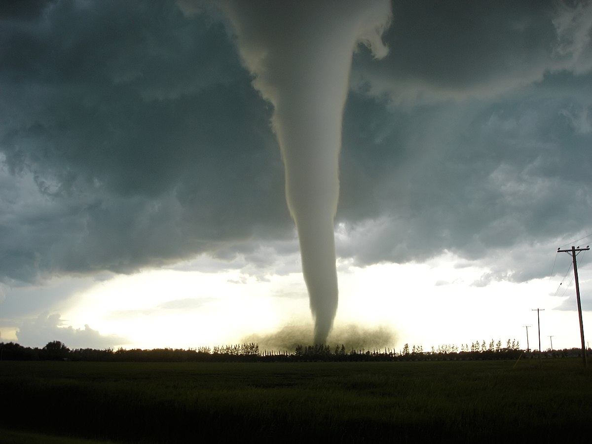
ON THIS DAY: Canada's Only Confirmed F5 Tornado - Elie, Manitoba - June 22, 2007

On June 22, 2007, Canada’s only F5 rated tornado destroyed parts of Elie, Manitoba. Canada adopted the Enhanced Fujita scale in 2013 so this will be the only F5 rated tornado in our history. With wind speeds in excess of 420 km/h, it caused $39 million dollars ($48 million in 2020 dollars) of damage destroying several houses, vehicles, and the town’s flour mill.

The tornado was narrow, given its strength, reaching a width of only 300 metres. It was on the ground for roughly 40 min and travelled about 6 km. The tornado winded its way through part of the town as can be seen in the figure below from Mccarthy, Patrick & Carlsen, Dave & Slipec, Jim. (2008). Elie, Manitoba, Canada, June 22, 2007: Canada's first F5 tornado. Houses were torn completely off of their foundations and a Chrysler Fifth Avenue was reportedly tossed onto a neighbour’s roof.

elietrack.png

Fortunately, no was killed and there were no seriously injuries. According to ECCC “Many residents were out of town attending a high school graduation ceremony, and those who were home knew what to do, seeking shelter in basements and placing mattresses over their head.”

Below are two videos from Justin Hobson’s channel who witnessed this historic event. The first one was taken by Justin and the second by the residents of Elie:

Events like this remind us that we must stay alert when there is severe weather in our region and, of course, have a plan! Also, we love your reports but please only take videos or photos if it safe to do so!

References and more information:

Canada’s First F5 Tornado, ECCC

2007 Elie, Manitoba tornado, Wikipedia

10 years later, Canada’s only F5 tornado remains in a class of its own, Washington Post

BREAKING: At Least One Death Reported After Tornado Causes Significant Damage in Montréal Suburb

Je vien de voir une tornade à mascouche souffler une maison....j'espère que les gens sont ok!

Posted by Nicolas Dubreuil on Monday, June 21, 2021

Video of tornado in Mascouche, Québec (EXPLICIT LANGUAGE WARNING)

A devastating story is unfolding just outside Montréal, Québec as what appears to be a very strong tornado has torn through the community of Mascouche (around 40km north of Montréal) during the afternoon hours on Monday. Based on radar data and local reports, it appears the tornado touched down around 3:30 PM ET and stayed on the ground for several minutes as it tracked through residential areas and resulted in severe structural damage to several houses.

No severe thunderstorm or tornado warning was issued by Environment Canada before the tornado touched down in Mascouche. Only a severe thunderstorm watch was in effect at the time. A tornado warning was only issued at 4:50 PM ET for the cluster of storms outside Québec City over an hour after the initial touchdown. All tornado warnings have since ended as of 7:00 PM ET.

According to CBC News, at least one person from Mascouche has died as a result of the tornado. There are currently no other reports of fatalities or injuries related to this event although it’s still very preliminary.

Shortly after the event, reports of damage flooded social media showing debris spread throughout a neighbourhood and some structural damage including what appears to be a house under construction that was torn apart.

Posted by Marco Paquette on Monday, June 21, 2021

We’ll be updating the article with more details as we receive any further information and our thoughts and condolences are with those who were affected by today’s storms.

"Ring of Fire" Annular Solar Eclipse (June 10 2021)

An annular solar eclipse on May 20, 2012.Credits: Dale Cruikshank

An annular solar eclipse on May 20, 2012.

Credits: Dale Cruikshank

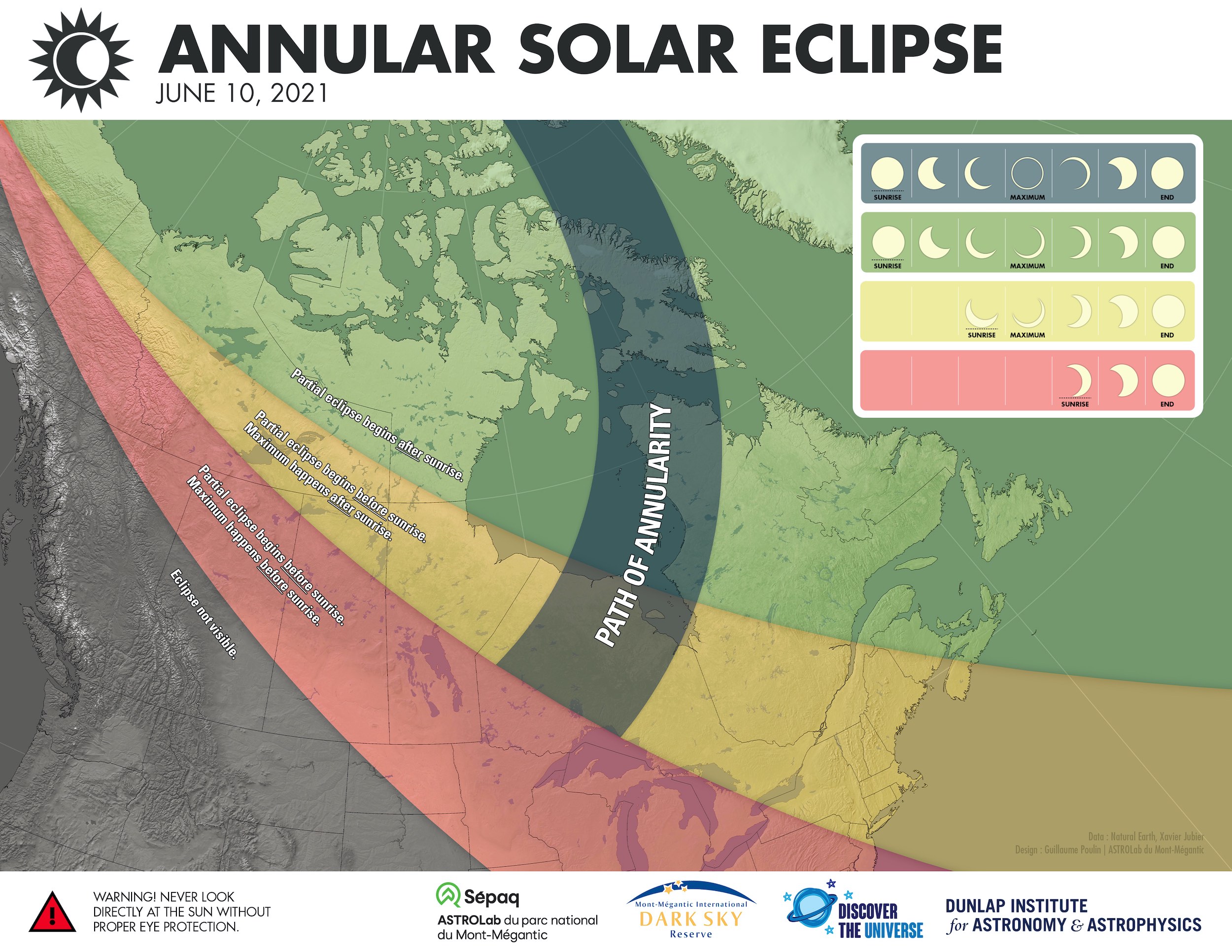
In the early morning hours on Thursday, June 10, 2021 observers in Northern Ontario, Northern Quebec, and Nunavut will have the rare chance of seeing a “Ring of Fire” or Annular Solar Eclipse, weather permitting of course.

An annular solar eclipse happens when the Moon passes in front of the Sun but is far enough away from the Earth that it does not completely cover the Sun as it would during a total eclipse.

Even if you are outside the “path of annularity” (grey in the figure below from the University of Toronto’s page on the eclipse) you may be able to see the moon partially obscuring the Sun or a partial eclipse. You will have to get up early to see it as the eclipse will have started before the Sun rises except for regions in the far north (green). The areas that are yellow on the map will see the maximum after sunrise. If you are in a location where the area is red you will only see a partial eclipse, the Moon will gradually uncover more and more of the Sun as the maximum will have occurred before sunrise.

Check out this page from timeanddate.com for more maps and information. You can also search for a specific location to see when and what you will see from timeandate.com as well. See the example below for Ottawa:

It is very important not to look directly at the Sun especially during an eclipse as you can damage your eyes. “When watching a partial solar eclipse or annular solar eclipse, you must wear solar viewing or eclipse glasses throughout the entire eclipse if you want to face the Sun. Solar viewing or eclipses glasses are NOT regular sunglasses; regular sunglasses are not safe for viewing the Sun.” from NASA's page on the eclipse.

Here are instructions on how to make a pinhole camera that you can use to safely view the eclipse in an indirect manner.

See also space.com for more information about the eclipse.

Hopefully the skies will be clear so that you can enjoy eclipse.

Damage Reports Near Wainwright Area From Tuesday, May 18, 2021

Here are some of the report and photos of the storm damage that occurred during the afternoon of Tuesday May 18 2021 near Wainwright. Thank you to everyone who shared their experience and reports with us and our thoughts are with those who were affected.

Paul L. writes: “Poles and trees down just west of Wainwright”

Carson R. “10 or so power poles snapped off 4 feet from the ground west of Wainwright”

Charleen T. “Had our 150 foot cattle shed torn in half. Poles pulled 4 feet out of the ground, wooden debris in the trees and the metal roof picked up and taken over the trees to land on the ditch on the other side. Trampoline tossed into the trees but the sandbox toys right beside we’re not disturbed…..” West of Paradise Valley


Glenda P shared these photos of downed poles 2km west of Wainright.


Charlene T. had three big evergreen trees uprooted in Wainwright. One is pictured below:

Charlene T - Wainright

Charlene T - Wainright


Lisa C. sent us these photos of her place in Wainwright.

Lisa C - Wainwright

Lisa C - Wainwright

Lisa C - Wainwright

Lisa C - Wainwright


Dominique R. sent us this picture of a horse shelter that was destroyed. They also had soffit that flew away and a shed that collapsed.

Dominique R - Wainwright

Dominique R - Wainwright


A well know business (Webb’s Machinery ) experienced substantial damage in the storm:

Edward C. - Webb’s

Edward C. - Webb’s


Bonnie WS shared these photos:


Debbie FR. reported “Hello, yes we had broken power poles , lost shingles and trees, hail . Our pool is in the trees and fence! Lots of flying trampolines and buildings. … We were out watching the storm roll in! Lots of loud rolling thunder! Wind picked up out of nowhere and blew furniture everywhere! Started raining big fat raindrops then turned to dime size hail for about 20 minutes! The wind and hail
Blew all the fresh green leaves off ! Looked like it had rained lettuce! Blue skies after about 20 minutes! Winds were very loud and clouds twirling”

Debbie F.R. Wainwright

Debbie F.R. Wainwright

Debbie F. R. - Wainwright

Debbie F. R. - Wainwright


Melaine P. reported “It just came up quickly! There was a lot of force with it. The light posts in our parking lot were wavering pretty good. Didn’t really see any damage, just small branches broken. The dirt that it was blowing made visibility not that great at times. We witnessed it from the second floor of our building, facing south. It lasted for probably 45 min to an hour, when the wind came down”


Julie D-C writes “My barn had a lot of damages: the front collapsed, a few panels flew away with shingles. We live North East of Wainwright, by Gilt Edge Hall.”

Julie D-C - Wainwright

Julie D-C - Wainwright


Darlene G - North of Wainwright

Darlene G - North of Wainwright


Chance F writes “Ripped the roof off a building right in front of us … But we were right in the middle of it and it was crazy. Truck was shaking and things were blowing everywhere. 8 power poles snapped in half about 200 yards from me”


Sandra C

Sandra C


Dian D. “Part of our roof was ripped off and what I witnessed prior to this was formation of what I thought dust devil or something to that effect in the fields neighbouring us to the south west”. Dian also share what the sky looked like just before.


Darren Jury “We lost a large tree inour driveway. Snapped off at 9’”

Darren J

Darren J


Chelsea L. sent us this video and wrote "This was south of Sedgewick around 245..."

Thank you for your help and we have submitted all of your reports to the NTP for further investigation.

Supermoon Eclipse (May 26 2021)

A telescopic visualization of the 2021 total lunar eclipse. Credits: NASA’s Scientifc Visualization Studio

A telescopic visualization of the 2021 total lunar eclipse.
Credits: NASA’s Scientifc Visualization Studio

This month’s full moon is not only a supermoon but there will also be a total lunar eclipse visible to much of North America (weather permitting) on the morning of May 26 2021 as well as other parts of the world.

A total lunar eclipse happens when the moon fully enters the earth’s shadow or umbra. The total eclipse phase will be visible near moonset in Western Canada and the United States. Observers in Eastern Canada will be able to see the start of the eclipse or penumbral phase before the moon sets. Unfortunately the martimes will not be able to see any part of the eclipse but can still enjoy the supermoon.

Below is NASA’s sheet on the lunar Eclipse. The times are in UT and you can convert UTC to your time using one of the many converters on the web. They note the times when the moon first touches the different parts of the earth’s shadow. The umbra is the darkest part of the shadow (red in the diagram below) and penumbra (grey) is when only part of sun’s light is being obscurred by the earth.

Check out this interactive map from timeanddate.com to see when and what part of the eclipse will be visible in a location near you and other locations. Some examples:

Space.com’s page also has great information about the eclipse.

The last supermoon total eclipse was nearly 6 years ago, and the next total lunar eclipse that will be visible over North America is next May. For more information about lunar eclipses in the coming decade see NASA’s page.

The full moon in May is called Flower Moon and also goes by the names of Corn Planting Moon, the Milk Moon, and the Hare Moon.

Supermoons occur when the moon is at its closest approach to the earth during the new or full phase. The orbit of the moon is elliptical and the distance from the earth to the moon varies quite a bit. It can be as close as 356,500 km at perigee (average is 363,300 km) or as far as 406,700 km at apogee (average is 405,500 km). There is a significant difference in the size and brightness of a supermoon and micromoon. A supermoon is 14% bigger and 30% brighter than a micromoon.

CREDIT: NASAJPL Edu

Educators and astronomy enthusiasts: JPL has an activity on how you could measure this difference over many months.

Strong Winds are Causing Power Outages and Damage Across the Province Today (April 30 2021)

The strong winds today are causing tree branches and trees to fall on power lines and buildings. This is making it a very busy day for fire departments, hydro companies and arborists across the province as they deal with the safety concerns, outages and needed cleanup that these damaging winds are causing. Downed power lines can also cause arcing and result in fires. There are also reports of transforms fires as well. It should also be noted that higher than normal number of elevator rescues in Toronto today are likely due to power outages.

The map below is from https://live.sinirji911.com/

From: live.sinirji911.com

From: live.sinirji911.com

https://www.torontohydro.com/outage-map

https://www.torontohydro.com/outage-map

The most up to date Toronto Hydro outage map can be found here. The following information is from Toronto Fire Active Incidents.

From toronto.ca

From toronto.ca

Hydro One is reporting 211 outages with 17,424 customers affected and those numbers are constantly changing.

Message on Hydro One website

Message on Hydro One website

Please stay safe and exercise caution especially if you come across downed power lines as they could still be live.

Tonight's Pink Supermoon (April 26 2021)

Credit: Photo of 2016 Supermoon Lauren D.

Credit: Photo of 2016 Supermoon Lauren D.

Tonight's full moon or Pink Moon is also a supermoon. The full moon in April is called Pink Moon not because it will appear pink but because of pink wildflowers (phlox) that bloom in the spring. Other names of the full moon in April are Sprouting Grass Moon, Fish Moon, Hare Moon, Egg Moon, and Paschal Moon.

Supermoons occur when the moon is at its closest approach to the earth during the new or full phase. The orbit of the moon is elliptical and the distance from the earth to the moon varies quite a bit. It can be as close as 356,500 km at perigee (average is 363,300 km) or as far as 406,700 km at apogee (average is 405,500 km). There is a significant difference in the size and brightness of a supermoon and micromoon. A supermoon is 14% bigger and 30% brighter than a micromoon.

If you miss tonight's supermoon you will get another chance next month with May's Flower Moon , which is also a supermoon and the moon will be slightly closer to earth (157km).

CREDIT: NASAJPL Edu

Educators and astronomy enthusiasts: JPL has an activity on how you could measure this difference over many months.

Fireball Lights Up the Sky in Southern Ontario (February 26 2021)

Did you see the fireball on Friday February 26 2021 at approximately 10:07pm? Perhaps you unknownly captured it on a security camera.

Thank you to Keely K and Jamie H who alerted us to the fireball and everyone who responded to our initial post and sent us videos.

Below is a compilation of some of the videos that our community members sent in to us:

This is a compilation of videos sent in by community members of the fireball that was observed in Southern Ontario on Friday February 26 2021 at around 10:07pm.

You can report fireball observations (and also send in videos if you have them) to the American Meteor Society (AMS) or it’s partner the International Meteor Organization (IMO). The reports not only alert them to potentially scientifically significant events, they also add to the database of knowledge about meteors.

Almost 300 reports (to date) of this bright fireball have been submitted from observers in Ontario, Michigan, New York, Ohio and Pennsylvania. It was also captured on cameras from the NASA Fireball Network and the Southern Ontario Meteor Network (Western). NASA Meteor Watch says that the first analysis indicates that the meteor appeared 90 km above Erieau on the northern shore of Lake Erie and then moved northwest at a speed of 105,800 kilometers per hour, crossing the U.S./Canada border before ablating 32 kilometers above Fair Haven, Michigan.

Bright fireball over southern Ontario around 10 PM local time Observers in Ontario, Michigan, New York, Ohio and...

Posted by NASA Meteor Watch on Friday, February 26, 2021

NASA Meteor Watch also says that the orbit suggests that the meteor is from a fragment of a Jupiter family comet, though it is possible that it is also asteroidal in origin.

There are many reports that the fireball appeared green from our community members and you can see that does look green in this screenshot from Mike L‘s video.

Screen capture from video from Mike L

Screen capture from video from Mike L

The fireball was as bright as the quarter Moon and with the estimated speed NASA Meteor Watch says that the fragment had a mass of at least 2 kilograms and a diameter of approximately 12 centimeters.

Thank you to Larry M from WIndsor for sending us this unique video showing the fireball’s reflection on this vehicle. Even if your security cameras don’t point up towards the sky you may still have captured this special event.

Alberta, Saskatchewan and British Columbia were also treated to a fireball earlier this week.

Fireball Lights Up the Early Morning Sky in Alberta, Saskatchewan and British Columbia

This article was last updated on February 25.

Did you see the fireball this morning? Capture it on video? If you did you can send in a report to the International Meteor Organization (IMO) or American Meteor Society (AMS). Below is a video that was submitted to the AMS by Marie.

This video has been uploaded on the American Meteor Society Website. AMS Event: 978-2021, Report 222919 (978ag-2021) - Edmonton CA\nMore info here: AMS Event...

From the following NASA Meteor Watch’s post, the meteor occurred at 6:23 AM (2021 February 22) and was first visible above Skeleton Lake and moved south of west before ablating above Perryvale:

Bright fireball seen over Alberta early this morning (2021 February 22 @ 6:23 AM) There have been over 150 reports of...

Posted by NASA Meteor Watch on Monday, February 22, 2021

Weather satellites that monitor lightning also imaged this meteor because it was so bright:

The Alberta fireball was also imaged from space... It was bright enough to be detected by the Geostationary Lightning Mappers onboard the GOES 16 and 17 weather satellites.

Posted by NASA Meteor Watch on Monday, February 22, 2021

Here is the current map showing the locations of the observers from the event page on the International Meteor Organization website.

AlbertaMeteor.png

There has been enough data to estimate the size, mass and orbit of some recent bright meteors. We will update this article if more information about the meteor becomes available.

Update February 23: There are now 7 videos of the meteor can be found at the IMO event page. Including this one from Mieszko in Edmonton.

Bright streak (maybe a comet or a meteor) over Edmonton, Alberta on February 22, 2021

Update February 24: AMS has received over 100 videos and 400 reports for this meteor. They produced this fantastic video with music (hint turn on the sound) featuring some of the videos that they received.

More info here: http://www.amsmeteors.org/2021/02/bright-fireball-over-alberta-canada-on-february-22-2021/

Update February 25: University of Alberta researchers were able to calculate the orbit of the meteor. Due to the speed and the orbit they have concluded that the meteor was a fragment of a comet about the size of a grapefruit up to basketball. More details can be found here.

Southern Ontario - Snowfall Reports for February 15-16, 2021

An impactful snowstorm that caused destruction across Texas up through the Ohio Valley also brought heavy snowfall accumulation to Southern Ontario between Monday and Tuesday. Many areas saw accumulation between 15-30cm with localized reports up to 50cm.

Below is a map of over 50 snowfall accumulation reports submitted by the Instant Weather community. We have overlaid it onto our final forecast for the event so you can see how each area performed compared to our forecast. Overall, 74.51% of all reports fell within our normal or localized forecast ranges. A few notable areas underperformed the forecast throughout the GTA and into Eastern Ontario around the Kingston region.

Thanks to everyone who submitted their reports to us!

Snowfall Report Legend

Blue: 5 - 10cm

Purple: 10 - 20cm

Red: 20 - 30cm

Dark Red: 30+cm

Southern Ontario Snowfall Reports - Feb. 15-16, 2021

Preparing for an Ice Storm: What You Need to Know

At Instant Weather, we have been closely monitoring a system that is expected to bring significant freezing rain to a large portion of Southern Ontario Christmas Eve. At this point in time, a large swath of the province is expected to receive a few hours of freezing rain, resulting in up to 15 mm of ice. Our latest forecast can be found here which outlines the risk of an ice storm. Ice storms, similar to hurricanes, are rated using a scale system called the Sperry-Piltz Ice Accumulation (SPIA) Index. This Index considers the amount of ice accretion and the strength of the winds when categorizing these storms. Based on the possible amounts of ice accretion and forecasted winds, it appears that we are looking at a Level 1 ice storm. This level of storm can result in some local power outages. The main concern is an increase in wind speed and heavy snow that is expected to follow the period of freezing rain which may result in an increase in power outages as branches and power lines receive additional weight.

SPIA Index, Copyright Author: Sidney K. Sperry

It is important to be prepared for these situations so we have put together a list of items you should have on hand in case of an emergency:

  • Flashlight (windup or battery operated)

  • Radio (windup or battery operated)

  • Extra batteries

  • Portable cell phone charger

  • Water (2 litres per person per day)

  • Non-perishable canned or dried food

  • Manual can opener

  • Blankets

  • Candles and matches or lighters

  • First aid kit and any prescriptions/medical items

  • List of emergency numbers

  • Cash

  • Gasoline

Not sure what kind of food to have ready? Dried food like rice and pasta along with canned tuna can go a long way. Other items such as bread and granola bars are good for fibre and non-refrigerated fruits like bananas, oranges and apples help break up the high-sodium content found in dried foods. For water, an easy way to store a large amount is to fill a bathtub and use the water for drinking, cooking, and flushing toilets.

Since ice storms occur during the winter and early spring months, keeping warm is a major concern during extended power outages from ice storms. Electric baseboard heaters and space heaters will not work. However, natural gas furnaces will still work, but electrical components such as the blower, which forces the warm air through the vents, will not. There are some propane heaters that can be used indoors, but be careful because outdoor propane heaters produce carbon monoxide, making them very dangerous to use inside a home.

Another item worth adding to your emergency kit arsenal is a generator. Generators are available in a variety of sizes and capacities based on individual needs. There are a few things to consider when picking a generator: type, power and additional features.

There are home standby generators that are permanently in place and start up automatically when the power goes out. These units are large and can be quite expensive. There are also smaller, portable generators that either run strictly on gas or on either gas or propane (dual fuel). There is an added benefit of running your generator on propane as it less expensive to run.

Every generator has two power ratings: starting watts and running watts. In order to determine the power of generator you need, you first need to determine what appliances will be running. In the event of an emergency, you may find that the only necessities are the fridge and furnace fan.

Source: Canadian Tire - Running and starting wattages of common appliances

It is EXTREMELY important to not run a generator in your house due to the risk of carbon monoxide poisoning.

With proper planning and preparation, everyone should be able to get through the stress that comes with extended periods without power. In the case of an ice storm, it’s important to stay indoors and reduce unnecessary travel. Also, we recommend not clogging up emergency lines with non-emergencies. Your power will be back before you know it!

References

www.campsafe.org/2014/02/07/hello-world-2/

www.canadiantire.ca/en/howto/project.html/project/outdoor/how-to-choose-a-generator.html

www.houstonpress.com/restaurants/10-tasty-foods-for-riding-out-a-hurricane-7688913

www.hydroone.com/power-outages-and-safety/emergency-preparedness

www.spia-index.com/index.php

Fireballs light up Ontario Skies in early December 2020

Three fireballs have been reported by Ontario residents during the past week including two last evening (Monday, December 7) and one during the day on Wednesday, December 2.

Conor M. shared this spectacular dash cam video of the 7:30pm fireball from last night.

The NASA Meteor Watch update of this fireball states that it occurred at 7:31 PM Eastern Standard Time. Over 150 reports were submitted from Ontario, Quebec and 12 states. Analysis of the video data from Western’s Southern Ontario Meteor Network showed the meteor was first visible above the town of Rossie, New York and disintegrated above Lyn, Ontario near Brockville. The estimated mass of the meteor was 3 kg and it had a diameter of 13 cm. The orbit that they calculated for this object suggests that it is from the Asteroid Belt between Mars and Jupiter and is not from the currently active Geminid meteor shower. The Geminid meteor shower, which peaks on December 13, is known to produce fireballs.

The “heat map” below is from the American Meteor Society event page and shows where people were located when they saw the meteor and its path (blue arrow) based on the observations.

Credit: American Meteor Society

Credit: American Meteor Society

For more information and videos of this fireball check out NASA’s fireball event page.

The second fireball occurred an hour later at about 8:30pm. This was not as widely reported and we do not have as much information about it. There are currently 28 reports from CT, DE, MD, NJ, NY, Ontario and PA. Here is the heat map from this event.

Credit: American Meteor Society

Credit: American Meteor Society

The fireball last week (December 2, 2020) was a rare daylight fireball that was not only spotted in Ontario and New York but also in 5 other states. The object was much larger than the ones from last night and is estimated to have had a mass of approximately 850-900 kg and had a diameter of 80-90 cm. This makes it close to being classified as an asteroid versus a meteoroid. When it broke apart the energy released was the equivalent of 66 tons of TNT.

Credit: American Meteor Society

Credit: American Meteor Society

A loud boom was reported as well around the time of this meteor. Sonic booms are associated with very bright meteors when they explode. The explosion that was produced by this bolide was also measured by seismic instruments in the area including one in Oshawa.

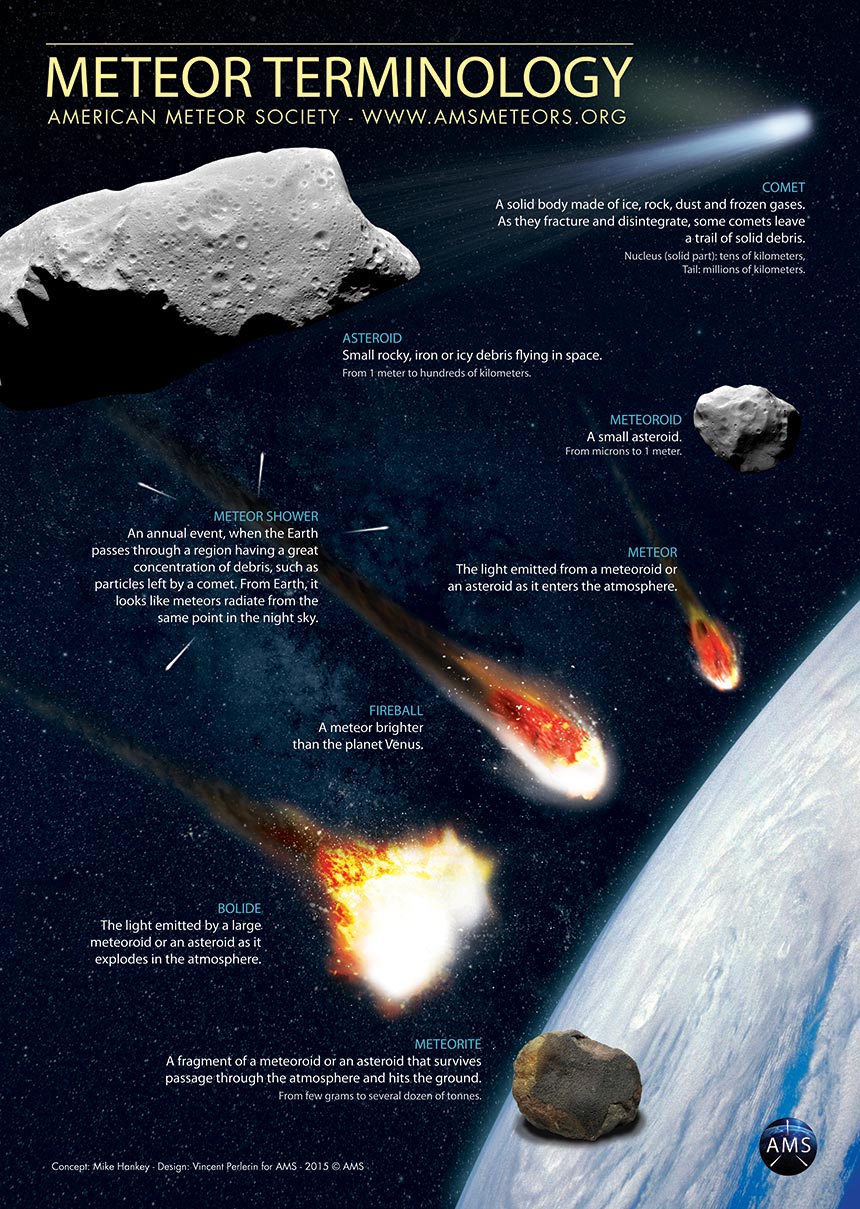
This poster from AMS explains the terminology of meteors.

If you see a fireball we encourage to you to report it to the either the American Meteor Society or the International Meteor Organization as your observations can help researchers.

The Full Moon on Halloween is a Special One

Credit: NASA/JPL-Caltech

Credit: NASA/JPL-Caltech

This year's full moon on Halloween has many names - blue moon, micromoon, Hunter's Moon, and the Beaver Moon are just a few. See this article from NASA for a discussion of the many names of Saturday's full moon.

Is this Halloween’s full moon a blue moon?

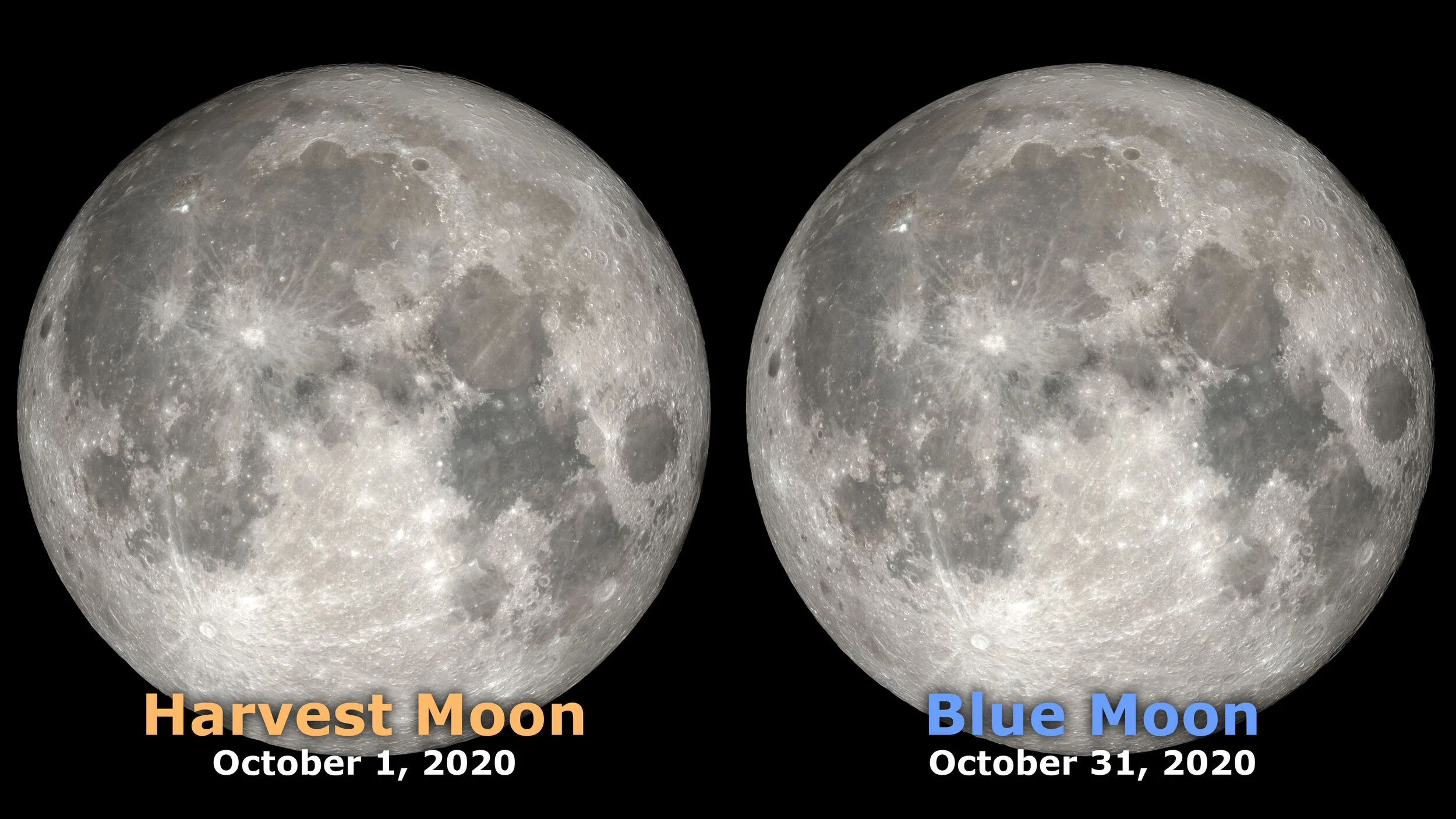
A common definition of a blue moon is the second full moon during the same calendar month. This means that all full moons on Halloween will also be a blue moon. Full moons occur every 29.5 days which is less than the number of day in October. So the answer is yes by this definition. NASA’s Scientific Visualization Studio created the image below.

CREDIT NASA's Scientific Visualization Studio

CREDIT NASA's Scientific Visualization Studio

Another traditional definition of a blue moon is that it is the third full moon in a season where there are 4 full moons. Normally a season has 3 full moons since it is 3 months long. The seasonal or traditional definition of a blue moon is independent of where you live and what time zone you are unlike the calendar definition. See https://en.wikipedia.org/wiki/Blue_moon#Blue_moons_between_2009_and_2037 for a list of seasonal and calendar blue moons between 2009 and 2037. The full moon on Saturday is not a seasonal blue moon.

What is a micromoon?

Saturday's full moon is also a micromoon. A micromoon is when the moon is at its furthest point in its orbit from the earth during its full or new phase. The orbit of the moon is elliptical and the distance from the earth to the moon varies quite a bit. It can be as close as 356,500 km at perigee (average is 363,300 km) or as far as 406,700 km at apogee (average is 405,500 km). On Oct 30 the moon is 406,394 km away. There is a significant difference in the size and brightness of a supermoon and micromoon. A supermoon is 14% bigger and 30% brighter than a micromoon.

Ever wondered why the Moon looks bigger and brighter during a supermoon? Watch this short animation to find out. Learn more about supermoons, here: www.jpl.n...

CREDIT: NASAJPL Edu

Educators and astronomy enthusiasts: JPL has an activity on how you could measure this difference over many months.


On average we will see a full moon on Halloween every 19 years. The next one will occur in 2039. If the sky is clear be sure to check out the full moon on Halloween as it is a special event that won’t happen again for quite a while.

Ontario’s Tornado Count Is Now Up to 32 for the Year; 2 Tornadoes on September 3 2020 Confirmed

Confirmed-tornadoes.jpg

The Northern Tornado Project (NTP) team investigated storm damage that occurred on the evening of September 3, 2020 at both Port Colborne and Washago. The preliminary results of their investigation is that there was a high end EF0 tornado in Port Colborne and a EF1 tornado in Washago. There have been five tornadoes that have been recenlty confirmed.

This brings the total number to 32 and we could potentially see more tornadoes in Ontario this year. NTP has only recently started investigating and confirming tornadoes in Ontario (see here for more information about the project, which was founded in 2017). NTP confirmed 23 tornadoes in 2018 and 13 tornadoes in 2019 in Ontario. Compare these numbers with the Ontario government’s average of 12. The average is expected to increase as tornado detection improves and we get a more complete picture of how often tornadoes occur.

This article focuses on the two tornadoes that occured on September 3. For information about the other recently confirmed tornadoes please see:

August 27, 2020 - EF1 at Mount Carmel and EF1 at Union

August 28, 2020 - EF0 at Point Clark

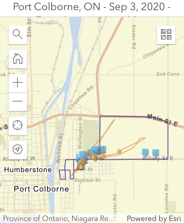
Port Colborne’s EF0 tornado (late evening) had a maximum wind speed 125 km/h, a path length of 1.1 km, and a maximum width of only 50 m. The tornado produced damage to some trees and houses.

The investigation map from NTP below shows the drone (orange) and the land (blue) survey paths. Click on the map to go to their site and view the photos.

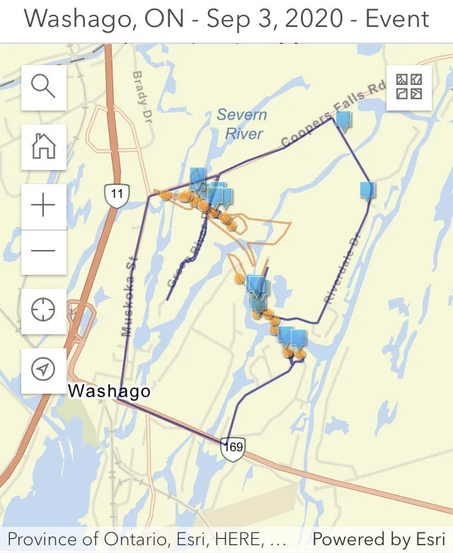
Washago’s EF1 tornado (evening) had maximum wind speed of 145 km/h, a path length of 1.85 km and a maximum width of 90 m. The tornado produced damage mainly to mature trees along a narrow path.

You can see the narrow path of the tornado in this video:

The investigation map from NTP below shows the drone (orange) and the land (blue) survey paths. Click on the map to go to their site and view the photos.


We sincerely hope everyone stayed safe in the path of these tornadoes and thank you so much to all of those who sent in reports! Your reports are critical in confirming tornadoes and continuing our goal to raise awareness about them and severe weather. Thank you!

Two More Tornadoes in Ontario; 2 EF1 Tornadoes on August 27 2020 Confirmed

The Northern Tornado Project team confirmed that two EF1 tornadoes occurred during the afternoon of August 27, 2020 in Southern Ontario.

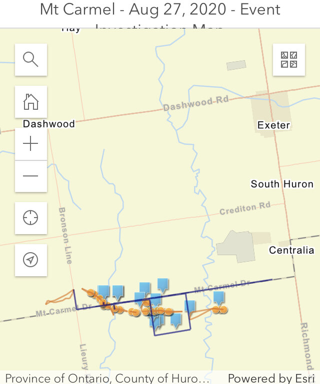
Their investigation of the tornado at Mount Carmel (2:30 PM) found that this tornado had a maximum wind speed of 155 km/h, 7.1 km long path with a width of 100m. The damage to the century barn can be seen in this tweet by Connell Miller from NTP:

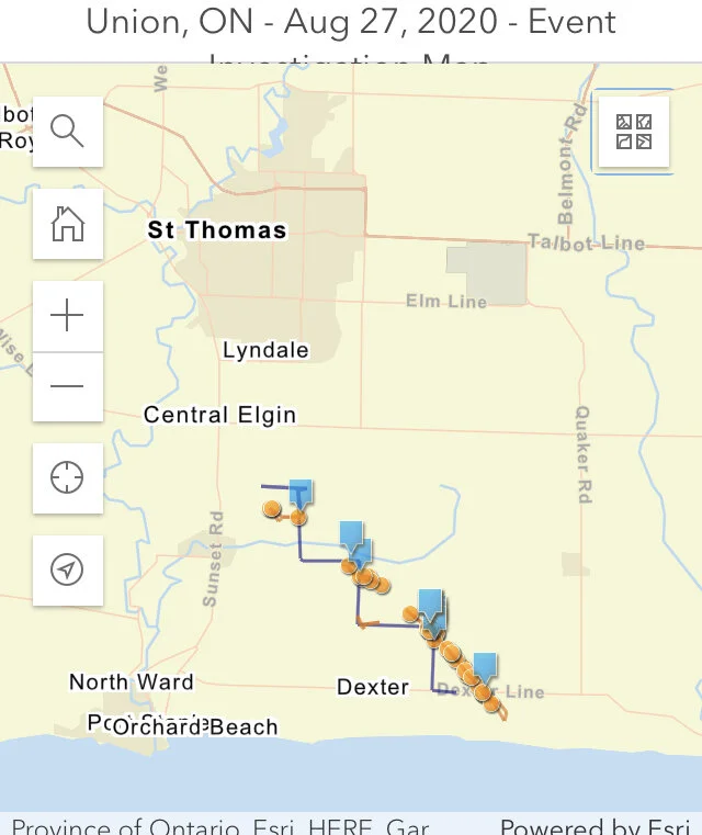
A second tornado at Union (St. Thomas area) which occurred at 3:15 PM had a maximum wind speed of 150 km/h, 5.2 km long path with a width of 150m. They found that a small century barn was shifted on its foundation as well as damage to trees and crops. If you look closely you can also see crop damage in second photo in the tweet below:

NTP has information about their investigations including photos and maps showing the land (blue) and drone (orange) survey paths and where the photos were taken. Click on the maps below to go to their site and view the details.


Timeline

11:30 AM: Environment Canada issued a Severe Thunderstorm Watch that included both areas affected by the tornadoes:


1:29 PM: Environment Canada issued a Severe Thunderstorm Warning that includes Southern Huron County (Mount Carmel):


2:06 PM: Environment Canada issued a Severe Thunderstorm Warning for an area that included Eastern Lambton County (just south of Mount Carmel)


2:39 PM: Environment Canada issued a Severe Thunderstorm warning for the area that included St. Thomas (Union):


2:45 PM: Adam went live.


3:12 PM: We notified all those in the path who use our app, text service, and social media pages “Tornado Reported” for the area near St. Thomas (Union).


3:12 PM: At the same time Environment Canada also issued a Tornado Warning for the St Thomas (Union) area:


Keep alert and trust your intuition if you think that the weather may be severe. The Mount Carmel tornado did not have a tornado warning. There can be many reasons why some tornadoes are not warned. Different areas have different radar coverage and some tornadoes do not have a strong radar signature. Some tornadoes may also form quickly and the associated radar signature is brief. Observations by reliable spotters play a role in tornado warnings as well.

We sincerely hope everyone stayed safe in the path of these tornadoes and thank you so much to all of those who sent in reports! Your reports are critical in confirming tornadoes and continuing our goal to raise awareness about them and severe weather. Thank you!

Embed Block
Add an embed URL or code. Learn more

Ontario's 29th Tornado Of The Year; EF0 Tornado Confirmed From Friday At Point Clark, ON With 130km/h Maximum Estimated Winds

(Radar Image courtesy of enVironment canada)

(Radar Image courtesy of enVironment canada)

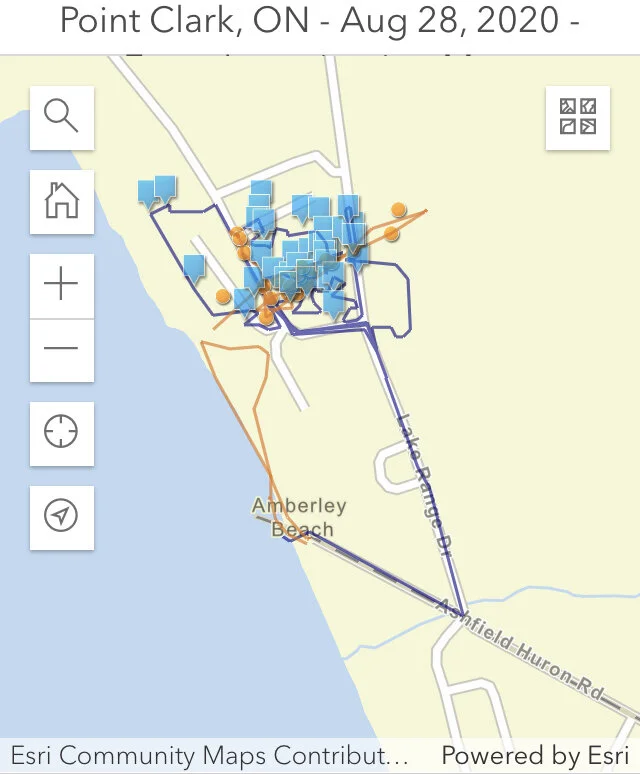
The Northern Tornado Project team has found damage consistent with a high-end EF0 tornado in Point Clark, Ontario. This tornado occurred at approximately 10:15 PM on Friday, August 28, 2020.  It adds to Ontario’s already very active tornado season being the 28th tornado in 2020 - more than double the average of 13! The estimated maximum wind speed was 130 km/h. They also found the path of the tornado to be 300 metres long with a maximum width of 80 metres. Note, the multiple directions that the trees fell which is a good indicator of a tornado:

You can also see the tree damage with the drone footage by Connell Miller:

Environment Canada also tweeted out this image showing radar images of the storm:

Mike Nailor shared some close up photos of the tree damage in the area:

The township sent out this news release the next day stating that significant damage had occurred:

The investigation map from NTP below shows the drone (orange) and the land (blue) survey paths. Click on the map to go to their site and view the photos.


Timeline

3:30 PM: We posted a heads up forecast that an isolated tornado was possible in the evening:

3:30 PM - Fri, Aug 28, 2020: Good afternoon! Keeping an eye on the potential for more strong thunderstorms later this...

Posted by Ontario Tornado Watch / Ontario Blizzard Watch on Friday, August 28, 2020

9:28 PM: Environment Canada issued a Severe Thunderstorm Watch:


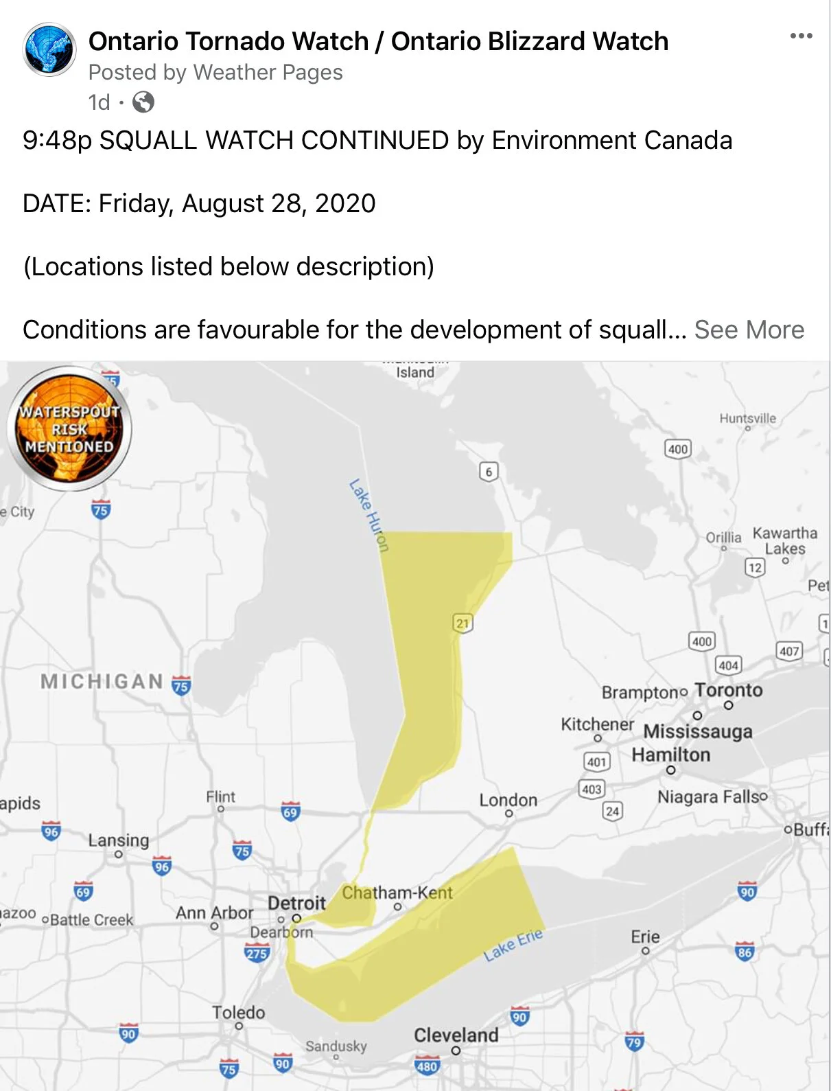
9:48 PM: Environment Canada issued a Squall Watch for Lake Huron mentioning waterspout potential.


9:51 PM: Environment Canada issued a Severe Thunderstorm Warning:


9:58 PM: With the help of Kevin Ramage, we notified all those in the path who use our app, text service, and social media pages “Minor Rotation Detected” and the potential of an isolated tornado:


10:05 PM: Environment Canada issued a Squall Warning for Lake Huron mentioning waterspout potential:


10:12 PM: Environment Canada upgraded the Severe Thunderstorm Warning to mention the potential of a tornado.


We sincerely hope everyone stayed safe in the path of this tornado and thank you so much to all of those who sent in reports! Your reports are critical in confirming tornadoes and continuing our goal to raise awareness about them and severe weather. Thank you!