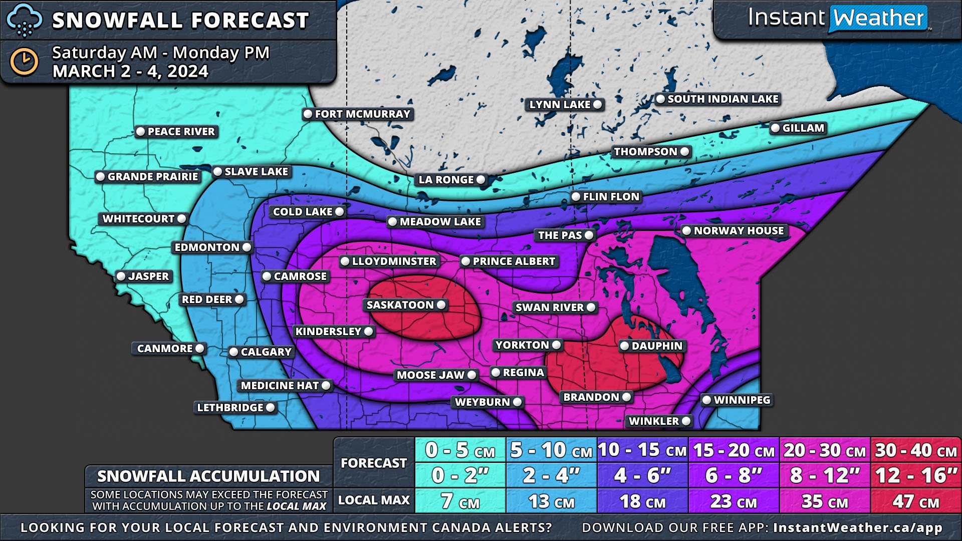
Major Winter Storm to Dump Up to 40cm of Snow on the Prairies for the First Weekend of March
/Just as we welcome the start of Meteorological Spring, the Prairies are bracing for a significant winter storm. The storm is set to begin on Saturday morning in Southern Alberta and Saskatchewan, spreading to Southern Manitoba by the afternoon. It will intensify overnight, extending northward and eastward.
By Monday night, Southern Saskatchewan and Manitoba will have received a widespread 20-30cm of snow, with isolated areas seeing 30-40cm. Southeast Manitoba will experience mixed precipitation and rain due to a warm front associated with the storm, which will limit snowfall totals there.
Alberta
In Alberta, light snow will start moving through Southern Alberta on Saturday morning, reaching the Edmonton area by early afternoon. The afternoon will bring moderate to heavy snow east of a line from Camrose through Drumheller to Medicine Hat, extending to the Saskatchewan border. This area is expected to receive 15-25cm of snow, primarily on Saturday afternoon and evening.
The snow will taper off from west to east by Sunday afternoon, though light flurries could persist for the next 24 hours. Wind gusts up to 50km/h on Saturday may cause blowing snow and reduced visibility.
Saskatchewan
Saskatchewan will experience a similar situation, with snow arriving from the south in the afternoon. However, the intensification and heavier snowfall will affect a larger portion of the province, resulting in 20-30cm of snow across its entire width. Two significant areas are expected to receive over 30cm of snow: one centred around Saskatoon, extending to North Battleford and Watrous, and another along the Manitoba border in the southwest, including Yorkton and Moosomin. Heavy snowfall, lasting 6-12 hours and accompanied by wind gusts up to 60km/h, could lead to blizzard conditions from Saturday afternoon until late Sunday.
manitoba
In Manitoba, the forecast is more complex. Light snow will start from the south on Saturday afternoon, continuing until early Sunday morning. Then, heavier, wet snow from the storm's center will cross the Saskatchewan border. Like in Saskatchewan, extensive areas of Manitoba will see 20-30cm of snow.
The secondary pocket of over 30cm of snow from Saskatchewan will extend into Manitoba, affecting places like Russel, Dauphin, Neepawa, Virden, and the West Interlake Region. Blizzard conditions, with wind gusts up to 70km/h, are a concern across Manitoba on Sunday. Heavy snow will persist until Monday morning and dissipate by Monday evening.
Southeast Manitoba, particularly the Eastman Region, the Red River Valley, and Winnipeg will face different conditions due to the storm's warm front, bringing in warmer air and a mix of ice pellets, freezing rain, and rain on Sunday afternoon. While overall snow accumulations will be lower here, conditions will remain messy. As the storm moves northeastward, snow will briefly return late Sunday into overnight.
The storm's track as it approaches Manitoba could still shift, potentially altering the forecast, especially for Southeastern Manitoba. An updated map may be issued to reflect any changes. A major shift in the storm's path could affect where the warm air intrusion occurs, significantly impacting the type of precipitation experienced in Southeastern Manitoba.


