Significant Blizzard Takes Aim at Manitoba Starting Saturday Night With Up 40cm of Snow Possible

NOTE: YOU CAN CLICK ON THE MAP TO OPEN A ZOOMABLE IMAGE


As we step into March, Manitoba prepares for a significant winter storm, marking a dramatic start to Meteorological Spring. This weekend, a powerful system will sweep across the Prairies, reaching Southern Manitoba by Saturday afternoon and intensifying through the night into Sunday.

This storm is set to blanket Southern Manitoba with 20-30cm of snow, with some regions bracing for as much as 30-40cm by Monday evening. However, Southeast Manitoba will face a unique challenge as mixed precipitation and rain, driven by a warm front, are anticipated to reduce overall snowfall totals in this area.


GOOGLE AD (NOT ENDORSED BY INSTANT WEATHER)

The storm's onset in Manitoba will be characterized by light snow beginning Saturday afternoon, and intensifying into early Sunday morning. As the storm's core advances across the Saskatchewan border, Southern Manitoba will be enveloped by heavy, wet snow. This will result in widespread snowfall accumulations of 20-30cm across a broad expanse of the province. Locations such as Russell, Dauphin, Neepawa, and Virden, extending across Lake Manitoba into the West Interlake Region could see up to 40cm of snow.

With wind gusts nearing 80 km/h, blizzard conditions are a significant concern throughout Sunday, making travel perilous and visibility severely reduced. Environment Canada has issued a blizzard warning for much of Western Manitoba. The relentless snowfall is expected to persist into Monday morning before gradually tapering off by the evening.


GOOGLE AD (NOT ENDORSED BY INSTANT WEATHER)

In contrast, Southeast Manitoba, including the Eastman Region, the Red River Valley, and Winnipeg, will experience a mix of precipitation types due to the storm's warm front. This warmer air from the south will initially bring light snow, followed by a combination of ice pellets, freezing rain, and rain by Sunday afternoon, complicating conditions further.

Although snowfall accumulations will be modest here, the mix of precipitation types will nonetheless create challenging and messy conditions. As the storm progresses northeastward, a brief return to snow is forecasted for late Sunday into the overnight hours.

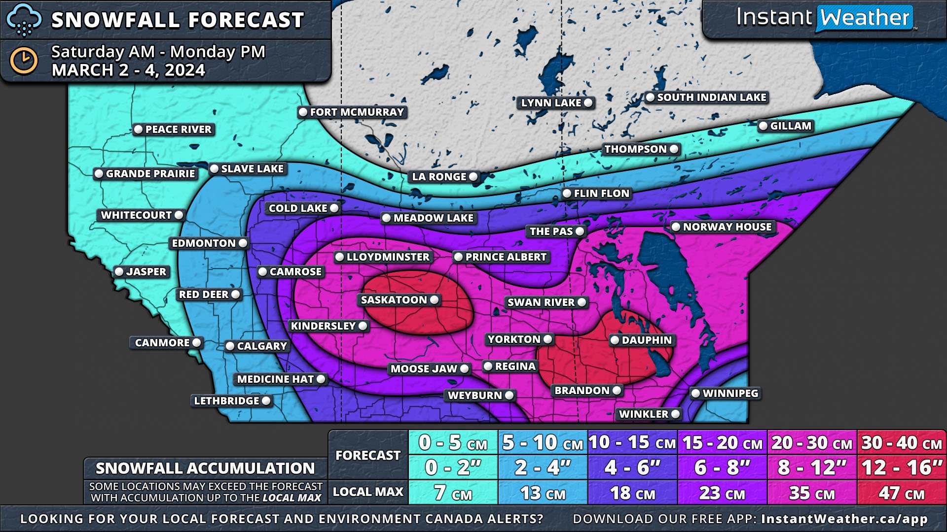
Major Winter Storm to Dump Up to 40cm of Snow on the Prairies for the First Weekend of March

NOTE: YOU CAN CLICK ON THE MAP TO OPEN A ZOOMABLE IMAGE


Just as we welcome the start of Meteorological Spring, the Prairies are bracing for a significant winter storm. The storm is set to begin on Saturday morning in Southern Alberta and Saskatchewan, spreading to Southern Manitoba by the afternoon. It will intensify overnight, extending northward and eastward.

By Monday night, Southern Saskatchewan and Manitoba will have received a widespread 20-30cm of snow, with isolated areas seeing 30-40cm. Southeast Manitoba will experience mixed precipitation and rain due to a warm front associated with the storm, which will limit snowfall totals there.


GOOGLE AD (NOT ENDORSED BY INSTANT WEATHER)

Alberta

In Alberta, light snow will start moving through Southern Alberta on Saturday morning, reaching the Edmonton area by early afternoon. The afternoon will bring moderate to heavy snow east of a line from Camrose through Drumheller to Medicine Hat, extending to the Saskatchewan border. This area is expected to receive 15-25cm of snow, primarily on Saturday afternoon and evening.

The snow will taper off from west to east by Sunday afternoon, though light flurries could persist for the next 24 hours. Wind gusts up to 50km/h on Saturday may cause blowing snow and reduced visibility.

Saskatchewan

Saskatchewan will experience a similar situation, with snow arriving from the south in the afternoon. However, the intensification and heavier snowfall will affect a larger portion of the province, resulting in 20-30cm of snow across its entire width. Two significant areas are expected to receive over 30cm of snow: one centred around Saskatoon, extending to North Battleford and Watrous, and another along the Manitoba border in the southwest, including Yorkton and Moosomin. Heavy snowfall, lasting 6-12 hours and accompanied by wind gusts up to 60km/h, could lead to blizzard conditions from Saturday afternoon until late Sunday.


GOOGLE AD (NOT ENDORSED BY INSTANT WEATHER)

manitoba

In Manitoba, the forecast is more complex. Light snow will start from the south on Saturday afternoon, continuing until early Sunday morning. Then, heavier, wet snow from the storm's center will cross the Saskatchewan border. Like in Saskatchewan, extensive areas of Manitoba will see 20-30cm of snow.

The secondary pocket of over 30cm of snow from Saskatchewan will extend into Manitoba, affecting places like Russel, Dauphin, Neepawa, Virden, and the West Interlake Region. Blizzard conditions, with wind gusts up to 70km/h, are a concern across Manitoba on Sunday. Heavy snow will persist until Monday morning and dissipate by Monday evening.

Southeast Manitoba, particularly the Eastman Region, the Red River Valley, and Winnipeg will face different conditions due to the storm's warm front, bringing in warmer air and a mix of ice pellets, freezing rain, and rain on Sunday afternoon. While overall snow accumulations will be lower here, conditions will remain messy. As the storm moves northeastward, snow will briefly return late Sunday into overnight.

The storm's track as it approaches Manitoba could still shift, potentially altering the forecast, especially for Southeastern Manitoba. An updated map may be issued to reflect any changes. A major shift in the storm's path could affect where the warm air intrusion occurs, significantly impacting the type of precipitation experienced in Southeastern Manitoba.

Fast-Moving Alberta Clipper Bringing a Widespread 10-20cm of Snow Across the Prairies Sunday and Monday

NOTE: YOU CAN CLICK ON THE MAP TO OPEN A ZOOMABLE IMAGE


FORECAST UPDATE - FEB. 25 @ 9:30 AM

The Prairies will finish the weekend with some fresh snow, courtesy of a fast-moving Clipper that will begin to move into Alberta overnight tonight. The snow will spread eastward throughout Sunday and most of Monday before making its way into Northern Ontario.

A large swath of Alberta can expect 10-20cm of snow by Monday afternoon with Edmonton and areas to the west being hit the hardest. This region will see snowfall totals approaching 20cm and possibly exceeding that amount locally. Most of this accumulation will occur in the late evening and overnight Sunday before starting to taper off Monday morning. Around Edmonton, the snow is expected to begin in the mid-afternoon and continue until mid- to late-morning on Monday.


GOOGLE AD (NOT ENDORSED BY INSTANT WEATHER)

The snow will cross into Saskatchewan Sunday evening and will spread across Central and Southern portions of the province through the overnight and early morning hours Monday. The heaviest snow will be concentrated to a line across Central Saskatchewan with a drop in snowfall accumulations moving northward and southward. Locations from Lloydminster, though Saskatoon to the Manitoba border can expect 10-15cm of snow throughout the day on Monday.

Things don’t start in Manitoba until early Monday and with the heaviest snow expected for Southern Manitoba as the Clipper continues its east-southeastward trajectory. The swath of 10-15cm will continue into the province from Saskatchewan but will only reach as far as across the Interlake Region because the back half of the storm starts to fall apart, and the snow begins to dissipate through Monday afternoon. Winnipeg, in particular, can expect the snow to be fairly short-lived and last less than 12 hours beginning after midnight Monday and continuing until mid-morning, resulting in less than 10cm of snow.


GOOGLE AD (NOT ENDORSED BY INSTANT WEATHER)

Temperatures ahead of the snowfall will be quite mild, with most of the Prairies reaching highs approaching or surpassing 0°, but they will rapidly plummet down to the negative double digits with the passage of the Clipper. Some areas could even see temperatures as low as -30° Tuesday night. This short blast of cold is expected to last for a couple of days before we return to more seasonal temperatures mid-week.